

November 3, 2014: This forecast update covers far southern Illinois, far southeast Missouri, and far western Kentucky. See the coverage map on the right side of the blog.
Monday – Partly sunny. Milder than recent days. High temperatures will be around 62-65 degrees. South/southwest winds at 5-15 mph.
Morning School Bus Stop Weather – Mostly sunny and cool. Morning temperatures around 40 degrees.
Afternoon School Bus Stop Weather – Partly sunny with temperatures around 64 degrees.
Monday night – Increasing clouds through the night. Low temperatures will be in the 40’s. South winds at 5-10 mph.
Tuesday – Mostly cloudy sky conditions. A chance for showers – especially over the western half of the region. Precipitation will slowly move east through the day. Much of Tuesday morning and early afternoon may remain dry for far southern Illinois and western Kentucky. High temperatures will be in the lower 60’s. South/southwest winds at 5-10 mph. Chance of rain 40%-60% by early afternoon increasing to 60%+ by late afternoon and evening.
Morning School Bus Stop Weather – Mostly cloudy. A small chance for a shower. Temperatures will be in the 46-52 degree range. South winds at 5 mph.
Afternoon School Bus Stop Weather – Mostly cloudy with a shower possible. Temperatures will be in the upper 50’s and lower 60’s. South winds at 5-10 mph.
Tuesday Night – Mostly cloudy with showers increasingly likely. Low temperatures will be in the upper 40’s. Winds will be from the north at 5-10 mph. Winds will turn out of the northwest after midnight. Chance of rain 80%.
Wednesday – Mostly cloudy with a chance for showers – a heavy downpour possible. High temperatures will be in the 55-60 degree range. Winds will be from the north at 5-10 mph. Chance of rain 80%.

An explanation of what is happening in the atmosphere over the coming days.
A storm system is approaching our region from the west. This system will spread clouds into the region today and into tonight. Temperatures will be warmer today ahead of the the system approaching from the west.
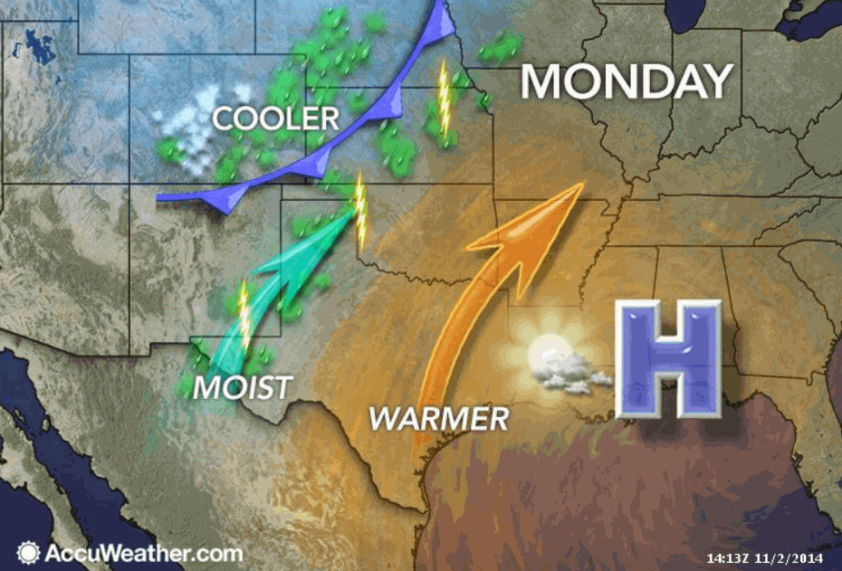
Clouds will thicken and lower late tonight into Tuesday morning. By the early morning hours of Tuesday, we should start to see rain on radar over portions of eastern Missouri into southwest Illinois. The rain will slowly progress east into southern Illinois, far southeast Missouri, and western Kentucky into Tuesday afternoon and Tuesday night.
A cold front will approach the region on Tuesday night. This front will slowly push eastward through Wednesday morning. The front is expected to slow a bit on Wednesday. That means that showers may linger into Wednesday afternoon over parts of western Kentucky.
The bulk of the precipitation is forecast to fall on Tuesday afternoon into early Wednesday morning. Rainfall totals should be in the 0.40″-0.80″ range. Totals exceeding 1″ appear possible. There is some question about the placement of a ribbon of heavier amounts (1″ or greater) that might extend into parts of far southern Illinois and western Kentucky. Rain will linger longer over the Missouri Bootheel into western Kentucky. We may still have rain on radar on Wednesday afternoon.
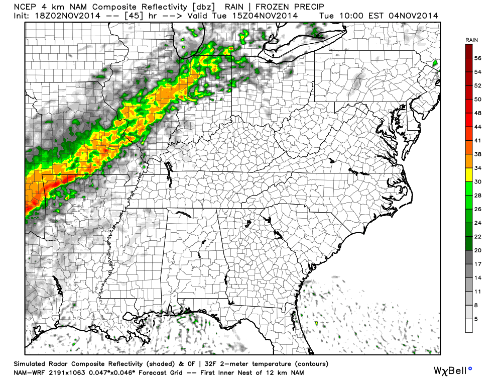
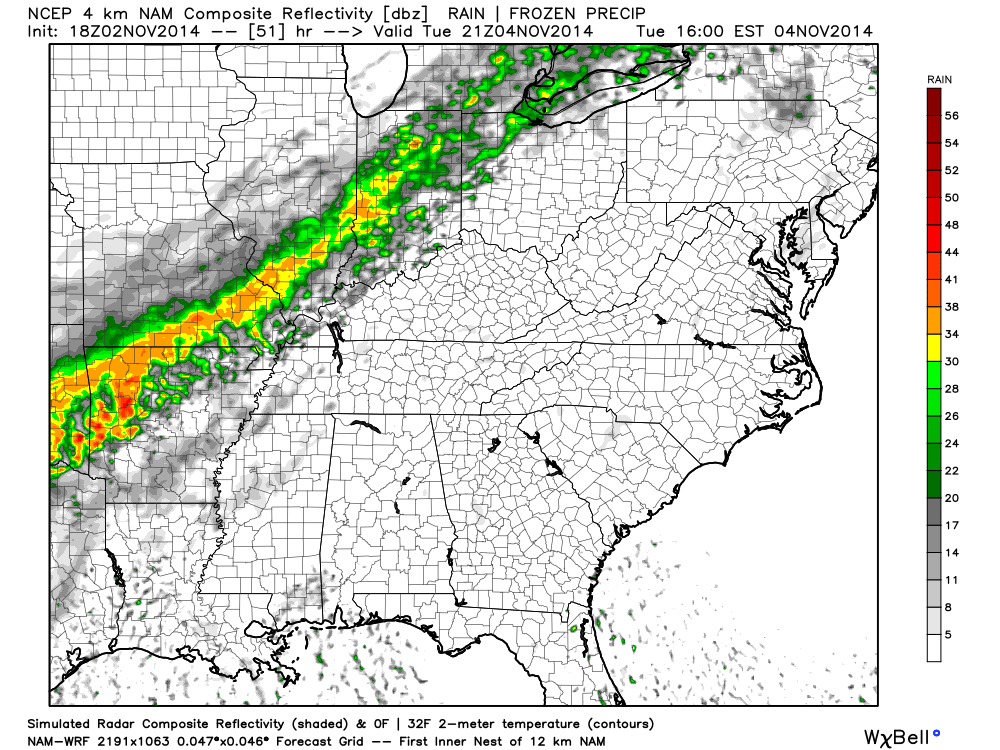
Here is the future-cast radar from the NAM model. These maps show you what radar is FORECAST to look like at a certain time frame.
Future-cast Radar Tuesday 9 AM – you can see rain approaching from the west.
Future-cast Radar Tuesday 3 PM
Future-cast Radar Tuesday 11 PM to 1 AM Wednesday morning – below
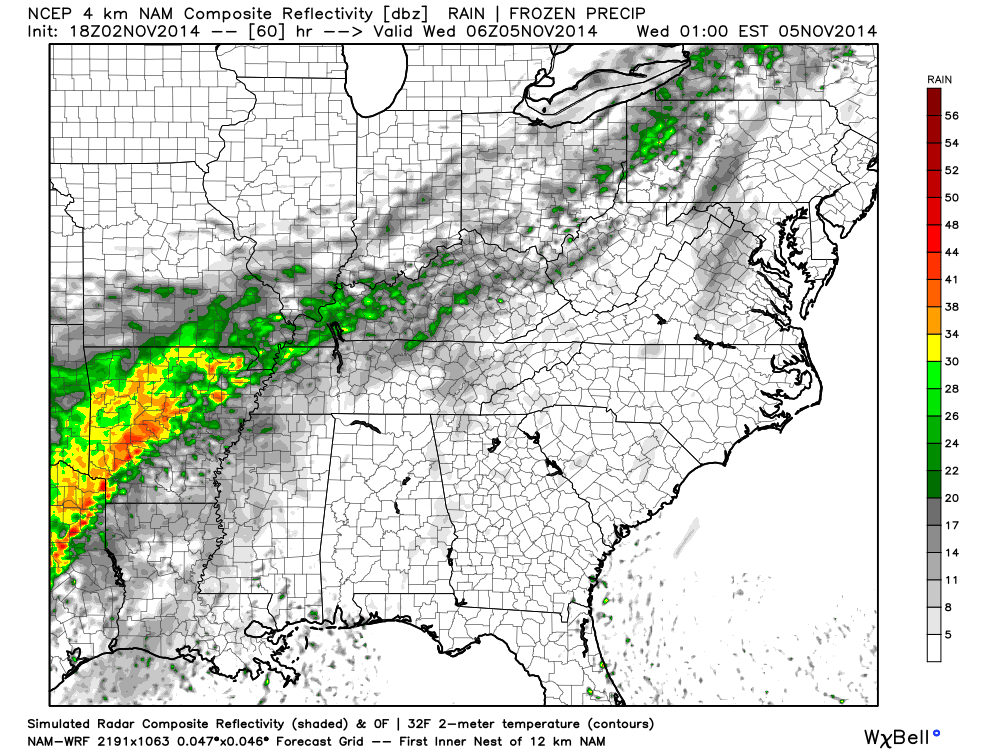
This final image is for the 9 am to 10 am time frame (below). Notice another chunk of moisture spreading northeast into the region. Some locally heavy downpours perhaps with that slug.
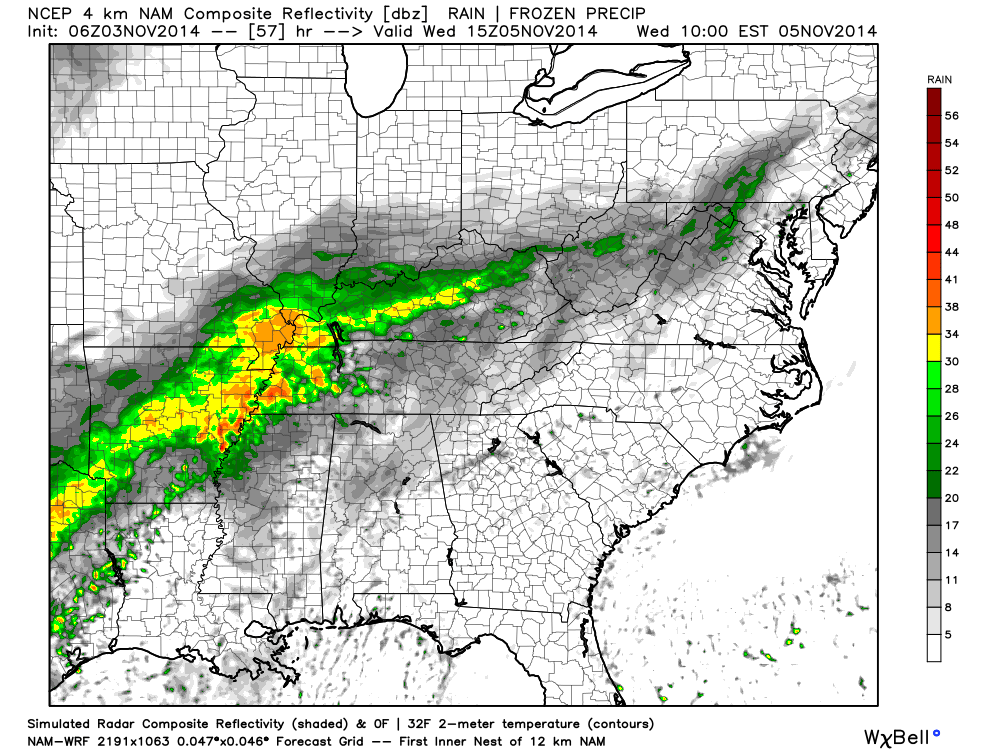
You can see the rain is slow to move.
Current Temperatures

Morning water vapor satellite imagery shows you the increasing moisture from the southwest. The white and blue colors indicate moisture. This is ahead of our next storm system.

Current dew points (an indication of how much moisture is in the air). The higher the dew point temperature the more moisture the cold front will have to work with. You can see that our dew points are quite low over the region. Look out to the west/southwest – the numbers are increasing. This is ahead of the cold front.


No major concerns with the ongoing forecast. I did change the wording a little bit on the timing of precipitation for Tuesday. The front is a slow mover. Rain showers should spread into the region on Tuesday into Tuesday night. Parameters for thunderstorms appear very low. This appears to mainly be a shower/rain event. Very small chance of a rumble of thunder.

The Wild Card gives you an idea of what might change that would cause the forecast to bust. A busted forecast means a forecast that does not verify. For example, if a winter storm (the area of low pressure) shifts its track 50 miles further south than expected, then that could cause a dramatic change in how much snow might or might not accumulate.
Wild card in this forecast continues to be rainfall totals on Tuesday into Wednesday morning. Some of the latest data has increased totals a bit over western Kentucky. I am thinking that most areas should pick up 0.40″-0.80″ of rain. The latest data does indicate that totals greater than 1″ will be possible, as well. A bit more iffy on the exact counties that would occur in. New data points towards portions of the Missouri Bootheel into western Kentucky and perhaps the southern tip of Illinois. If you are a raindrop counter then keep that in mind!
Also the exact timing that precipitation will move into the Cape Giardeau to Carbondale to Evansville area and eastward remains a bit of a question mark. Certainly the best chances will be Tuesday night into Wednesday. Whether rain moves into these areas before 3 pm on Tuesday is questionable.

Can we expect severe thunderstorms over the next 24 to 48 hours? Remember that a severe thunderstorm is defined as a thunderstorm that produces 58 mph winds or higher, quarter size hail or larger, and/or a tornado.
Severe weather is not going to be a concern through Tuesday.
Thunderstorm threat level is zero.


Umbrellas will likely be needed on Tuesday into Wednesday morning. This is especially true the later we move into the day on Tuesday and Tuesday night. Again, western areas of southeast Missouri and southwest Illinois will experience the rain first.

Please visit your local National Weather Service Office by clicking here. The National Weather Service Office, for our region, is located in Paducah, Kentucky.
![]()
We have regional radars and local city radars – if a radar does not seem to be updating then try another one. Occasional browsers need their cache cleared. You may also try restarting your browser. That usually fixes the problem. Occasionally we do have a radar go down. That is why I have duplicates. Thus, if one fails then try another one.
If you have any problems then please send me an email beaudodson@usawx.com
WEATHER RADAR PAGE – Click here —
We also have a new national interactive radar – you can view that radar by clicking here.
Local interactive city radars include St Louis, Mt Vernon, Evansville, Poplar Bluff, Cape Girardeau, Marion, Paducah, Hopkinsville, Memphis, Nashville, Dyersburg, and all of eastern Kentucky – these are interactive radars. Local city radars – click here

Regional Radar – Click on radar to take you our full radar page.


Regional Radar

Current WARNINGS (a warning means take action now). Click on your county to drill down to the latest warning information. Keep in mind that there can be a 2-3 minute delay in the updated warning information.
I strongly encourage you to use a NOAA Weather Radio or warning cell phone app for the most up to date warning information. Nothing is faster than a NOAA weather radio.

Missouri Warnings

Illinois Warnings

Kentucky Warnings
I have added a lot of new maps to the Southern Illinois Weather Observatory web-site. Check them out by clicking here.

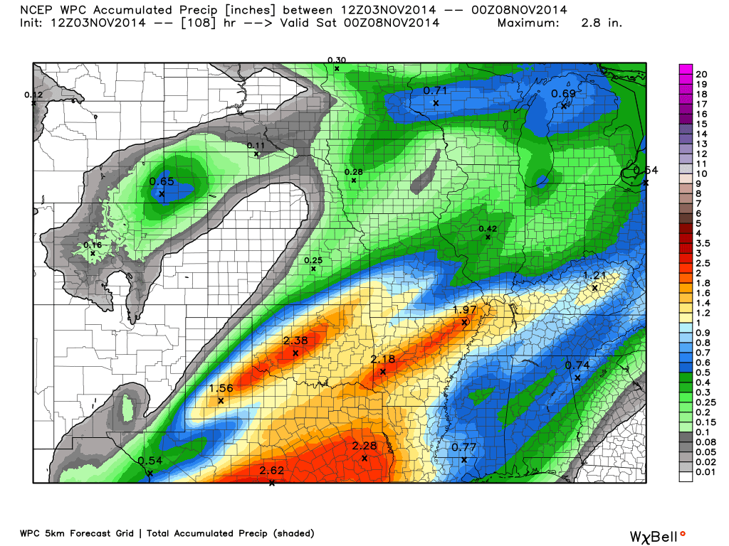
The latest rainfall forecast indicates that our region should pick up 0.40″-0.80″. Most of this should fall on Tuesday into Wednesday morning. The front may stall out over parts of western Kentucky. This may keep rain in the forecast past Wednesday morning.
Here is a broad-brushed graphic showing you what to expect as far as rainfall totals through Wednesday morning. Again, this is a “general” idea.
There has been an overall shift in moving the heavier rainfall totals a bit further east into parts of western Kentucky. A few days ago it appeared that the bigger totals would be west of far southern Illinois and western Kentucky. So, perhaps parts of the above mentioned areas will pick up an inch or more of rain. I feel good about saying 0.40″-0.80″. We will see if totals go above that. Certainly a possibility.
Scale is on the right side of the image.

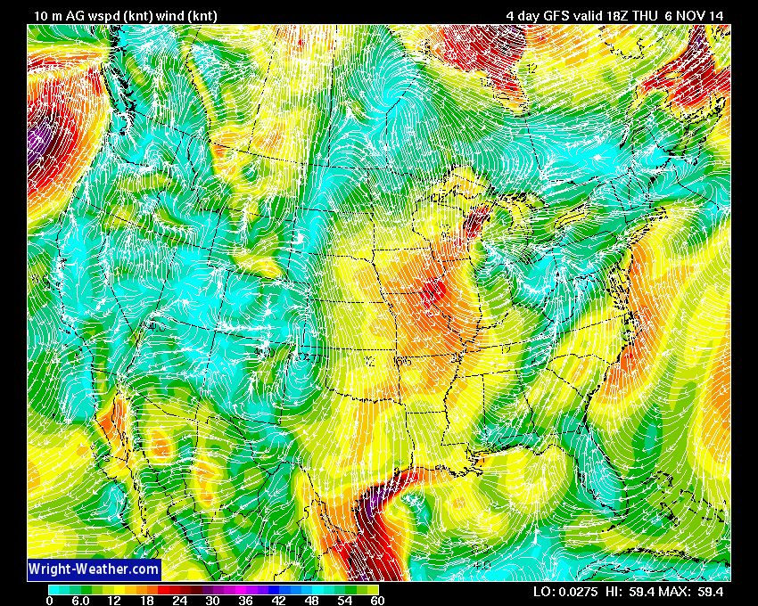
Another clipper system will move out of Canada by the end of the week. This will once again spread rain into parts of the Ohio Valley. The system should be far enough northeast of our local area to prevent widespread precipitation. It will, however, cause a bit of a squeeze play between the area of low pressure (over Michigan) and high pressure (over the Midwest). The tight isobars (see those light blue lines that are closely packed together over Illinois/Missouri) on this map indicate windy conditions.
Expect windy and cooler temperatures as this system moves southeast through Illinois and Indiana on Thursday and Friday.
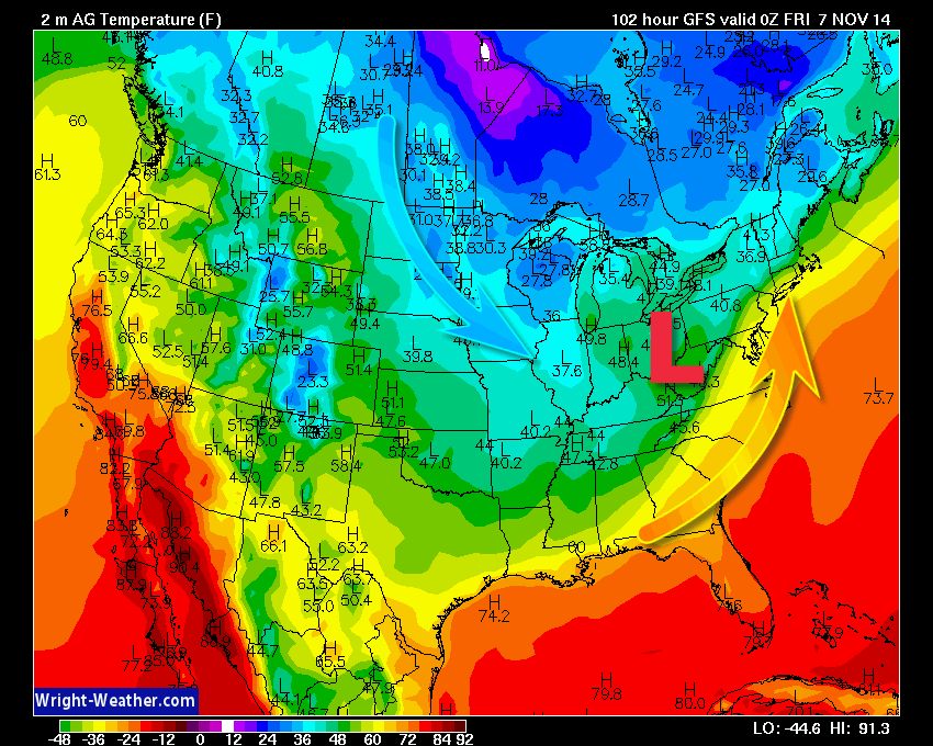
The purple and pink colors on this map indicate rainfall (or snowfall if you go far enough north into Wisconsin)
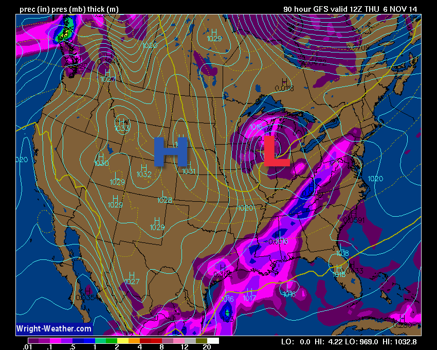
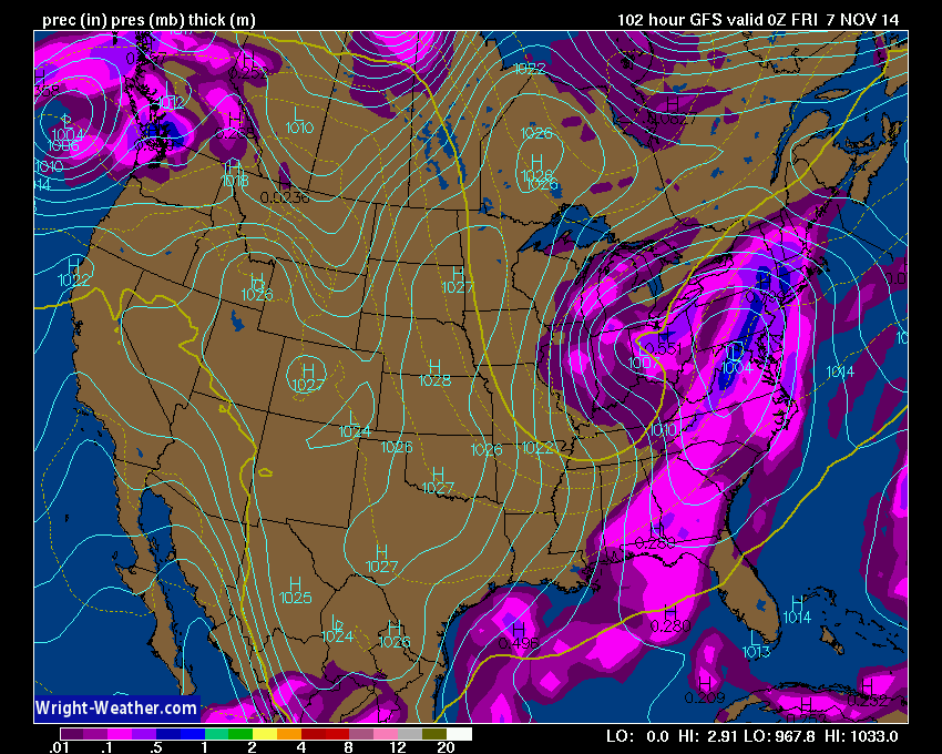
The above map is what the weather map should look like on Thursday evening. You can see precipitation trying to approach our region from the north (the pink and purple area). It does appear the bulk of the rain will stay to our east/northeast. If the system were to shift further southwest then the forecast would change. For now, it appears the low will pass well to our northeast.
Here is the wind map for Thursday afternoon. Those tight isobars (I mentioned above) match up with where the strongest winds should be. The bright yellow and orange colors indicate winds of 15-25 mph. Nothing severe, but enough to blow the leaves around a bit.
You can see how that next system pulls in cool air behind it. Remember that the area of low pressure rotates counter-clockwise. Warm air spreads northward ahead of the low and cool/cold air sweeps in behind the low. Makes sense…right? The counter-clockwise movement.
Below is the temperature forecast map for Thursday evening. This will be dependent on the strength of the low and the placement of the low.
As we look out over the next few weeks there are a few items that grab my interest. The long range models are indicating an active weather pattern with several east coast storms. With each one of these storm systems we will see the jet stream buckle. That means cooler weather will be associated with each passing storm.
The models are also indicating that one or more storm systems may approach our region from the southwest. If this occurs then we could see several rounds of rain.
Currently I don’t see a strong signal for a severe weather event or wintry precipitation, but I will continue to monitor. We are entering the time of year where the weather can rapidly change from one day to the next. It is not uncommon to have severe weather during the Month of November. Keep that in mind as the holiday shopping season begins. I know our lives start to become a bit busier this time of the year.

What causes a ring around the moon or sun?
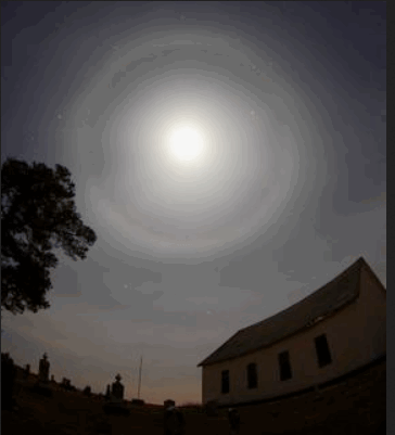
ANALYSIS AND INTERPRETATION: As an upper level disturbance approaches or warm front approaches the clouds tend to start off as high clouds. Over time the clouds gradually lower and thicken. Near the source of the greatest synoptic lifting is where precipitation and thick clouds are most likely. The sun or moon will no longer be visible once the clouds thicken too much.
The ring around the sun or moon is caused by ice crystals within thin cirrus clouds. The refraction causes light to shine into a ring. Cirrus clouds are generally the first layer of clouds that are seen as a storm system approaches.
PITFALLS: a. Cirrus clouds not associated with a storm system will produce the ring also. In these cases precipitation may not occur.
Thanks to Jeff Haby for the explanation of this phenomenon.
If you are interested in Storm Spotter classes then check out the link below.
STORM SPOTTER CLASS SCHEDULES
Current tower cam view from the Weather Observatory- Click here for all cameras.

Southern Illinois Weather Observatory
WPSD TV 6 has a number of tower cameras. Click here for their tower camera page
& Kentucky Road Conditions & Kentucky Highway and Interstate Cameras

Downtown Paducah, Kentucky
Benton, Kentucky Tower Camera – Click here for full view

Benton, Kentucky
WSIL TV 3 has a number of tower cameras. Click here for their tower camera page
& Illinois Road Conditions

Marion, Illinois

You can sign up for my AWARE email by clicking here I typically send out AWARE emails before severe weather, winter storms, or other active weather situations. I do not email watches or warnings. The emails are a basic “heads up” concerning incoming weather conditions.