

November 2, 2014: This forecast update covers far southern Illinois, far southeast Missouri, and far western Kentucky. See the coverage map on the right side of the blog.
Sunday – Mostly sunny during the morning hours. An increase in clouds during the afternoon. A few sprinkles or showers around after 2 pm. Below normal temperatures. Highs will be in the 50-55 degree range. Winds becoming southerly at 5-10 mph.
Morning Church Service Weather – 9 am temperatures will be in the 32-36 degree range. Mostly sunny sky conditions.
Sunday night – A few clouds, otherwise clear sky conditions. Cool with below normal temperatures. Low temperatures will be in the 34-38 degree range. Southerly winds at 5-10 mph.
Sunday Evening Church Service Weather – A few clouds and light sprinkles/showers. Temperatures will be around 50 degrees.
Monday – Mostly sunny. Milder than recent days. High temperatures will be around 60-64 degrees. South/southwest winds at 5-15 mph.
Morning School Bus Stop Weather – Mostly sunny and cool. Morning temperatures around 35-38 degrees.
Afternoon School Bus Stop Weather – Mostly sunny with temperatures around 62 degrees.
Monday night – Increasing clouds through the night. Low temperatures will be in the 40’s. South winds at 5-10 mph.
Tuesday – Mostly cloudy sky conditions. A chance for showers. High temperatures will be in the lower 60’s. South winds at 5-10 mph. Chance of rain 60%-80%.
Morning School Bus Stop Weather – Mostly cloudy. A chance for a shower. Temperatures will be in the 46-52 degree range. South winds at 5 mph.
Afternoon School Bus Stop Weather – Mostly cloudy with some showers likely. Temperatures will be in the upper 50’s and lower 60’s. South winds at 5-10 mph.

An explanation of what is happening in the atmosphere over the coming days.
Chilly high pressure has settled over our region. This has brought some of the coolest air of the season to our local counties. Temperatures this morning are mostly in the 20’s. We will warm into the lower 50’s this afternoon. Normal highs for this time of the year are around 65 degrees. A couple of sprinkles or showers will be possible later today. These showers won’t amount to much.
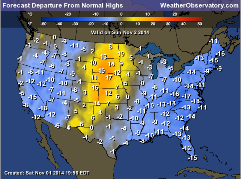
How many degrees below normal will we be today? Well, check out this map! Most of the eastern United States will be below normal in the temperature department. Our region will be between 8 and 14 degrees below normal. Note that temperatures will be above normal across portions of the Midwest (ahead of our next storm system).
Current temperatures

Temperatures won’t be quite as cool tonight. Expect lows on Monday morning to be in the 30’s. Still jacket/coat weather for the kids as they march off to school.
Temperatures will start to moderate a bit by Tuesday. This is because a new storm system will approach our region from the west. As the storm system approaches it will pull warm/moist air into the region. Remember that these systems spin counter-clockwise. Thus, warm air is pulled northward ahead of the system. Once the low moves off to our east/northeast then colder air pulls in behind the system.
A cold front will move through the region on Tuesday. A band of showers will accompany the front. Not expecting any severe thunderstorms with this particular system. Mainly just rain showers. Rainfall totals should range from 0.40″-0.80″. Perhaps a few locations will receive a bit more than that – mostly over parts of southeast Missouri and perhaps southwest Illinois (see the map posted below).
You can already see that next storm system on the water vapor satellite map. This satellite view shows you where moisture is located (the blue and white colors). You can see moisture being pulled northward across portions of the Rocky Mountains. You can almost see the counter-clockwise circulation around Idaho and Montana. Notice the fetch of moisture over portions of the Pacific Ocean into Mexico.

Another front will approach the region later in the work week. This will help keep temperatures below normal.
Here are some model charts
Sunday morning temperatures will start out chilly! Note the widespread 20’s over our region.
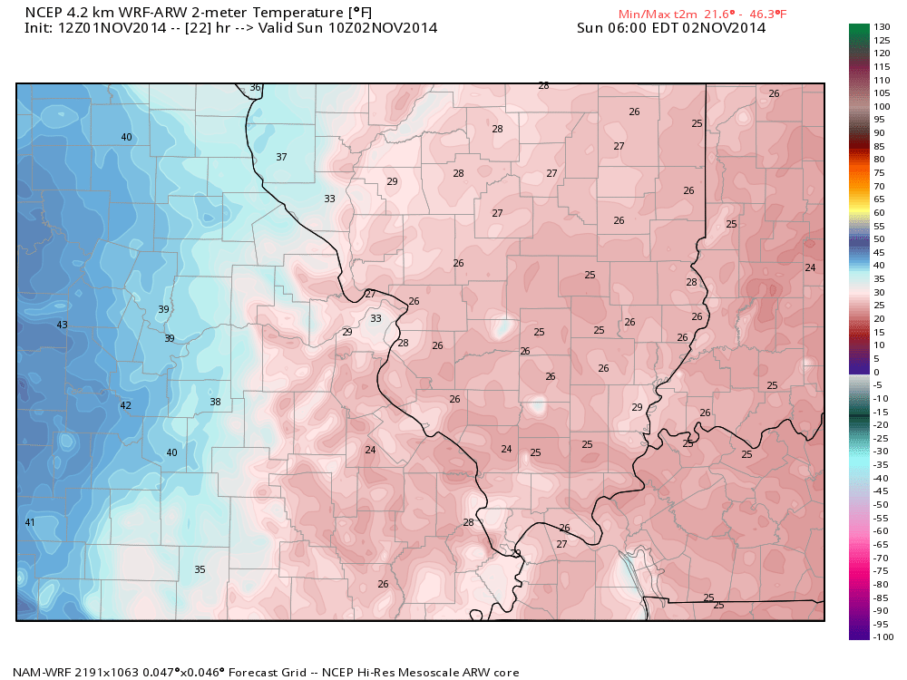
SUNDAY MORNING TEMPERATURES
Temperatures by Sunday afternoon will warm up just a little bit. Well below normal for this time of the year.
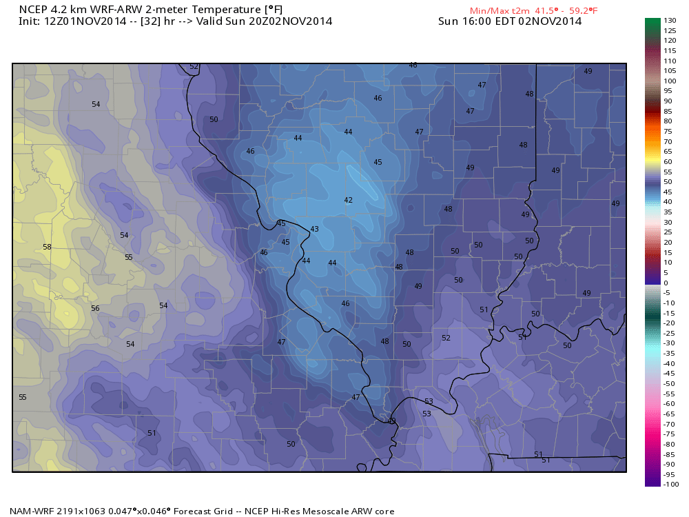
SUNDAY AFTERNOON TEMPERATURES
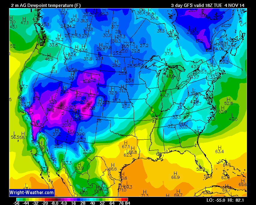
Dew point map for Sunday. Note the very low dew point readings across the Ohio Valley. This indicates dry air. These low dew points are an indicator of the cold air mass situated over much of the eastern United States. Notice the bump in dew points over portions of western Nebraska and Kansas? This is an indicator of our next storm system. Dew points typically RISE ahead of cold fronts. When dew points rise it means that the atmosphere is starting to moisten up. Warm and moist air is pulled northward from the Gulf of Mexico.
But, for today dew points will be very low. Dry air covers the region. Now watch what happens as we move into Monday and Tuesday. Dew points will rise. Moisture will move back into our region (second image below).
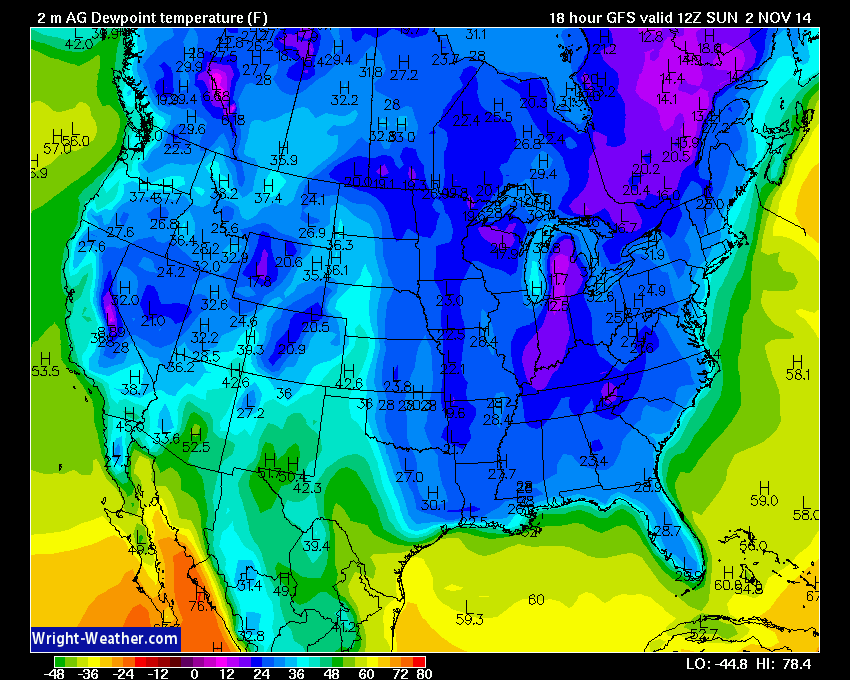
SUNDAY DEW POINTS
The dew point map for Tuesday. Not the tongue of higher dew point readings (the green and yellow colors)? Moisture streaming northward from the Gulf of Mexico and from Texas. This is ahead of the cold front. Note how dew points are lower behind the cold front across portions of Iowa, Kansas, and Missouri. Again, moisture is pulled northward ahead of storm systems and then moisture levels falls behind the system.
TUESDAY DEW POINT TEMPERATURES
Future-cast radar for late Monday night and the wee early morning hours of Tuesday. You can see the storm system moving eastward into our region. The green and yellow colors indicate rain showers. Again, this is a future-cast radar. This image indicates what the NAM model believes radar will look like around 1 am-3 am Tuesday morning. The precipitation will push eastward through Tuesday morning. That means we will have showers in the forecast throughout the day on Tuesday.
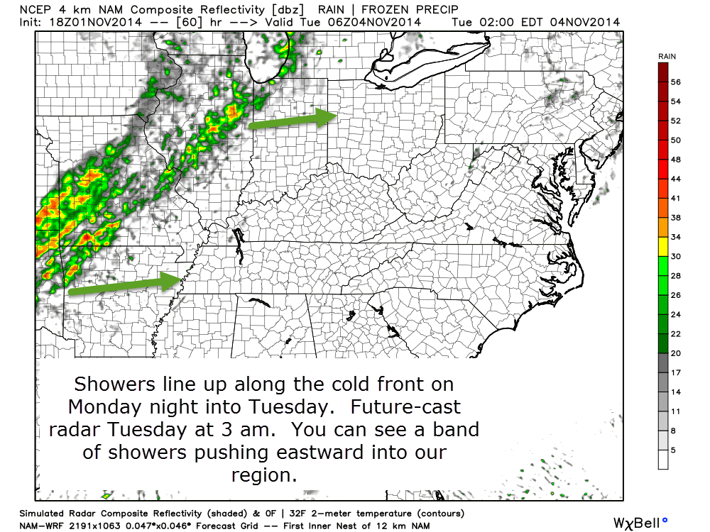
FUTURE-CAST RADAR
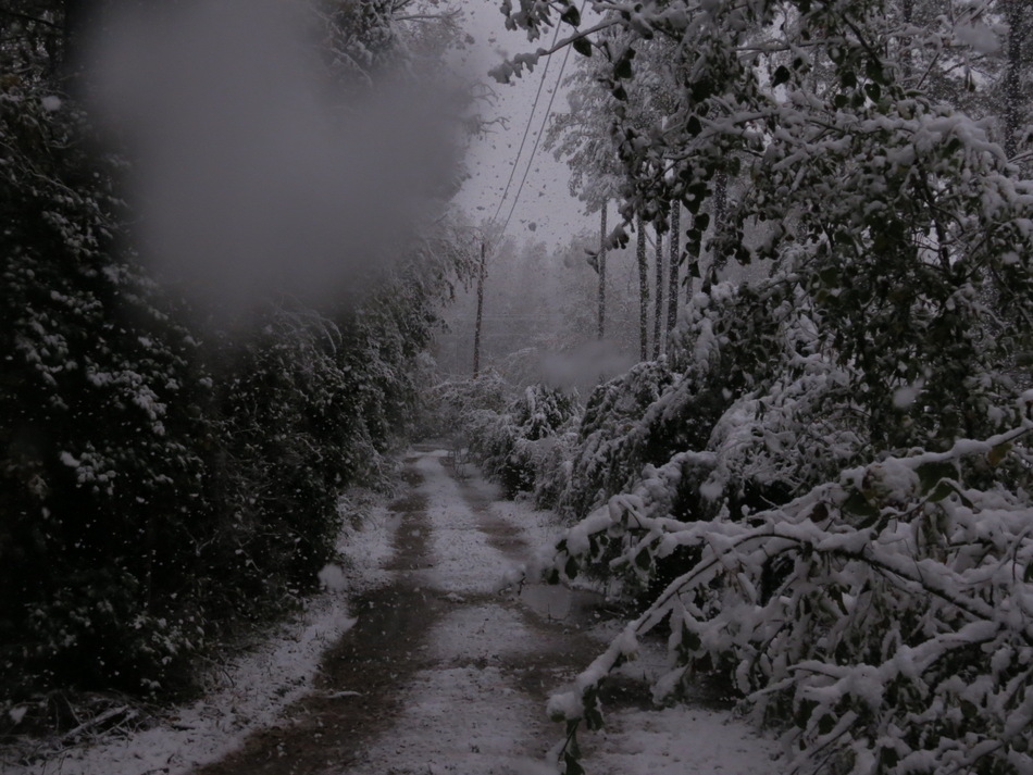
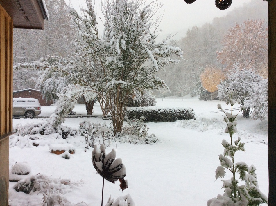
Can you believe that it snowed across portions of North and South Carolina on Saturday? Heavy snow fell across portions of the Smokey Mountains. The Gatlinburg, Tennessee area picked up several inches. As much as 18″+ were reported in some spots (higher elevations). Quite unusual for this time of the year.
These two photographs are from Wunderground.com
South Carolina Snow!
Barnardsville, North Carolina Snow
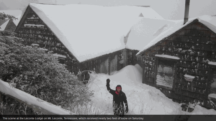 Mt. Leconte in the Appalachians.
I suppose our frost and freeze conditions were not THAT bad! At least it didn’t snow!

No major concerns for the upcoming 24-48 hour period.

The Wild Card gives you an idea of what might change that would cause the forecast to bust. A busted forecast means a forecast that does not verify. For example, if a winter storm (the area of low pressure) shifts its track 50 miles further south than expected, then that could cause a dramatic change in how much snow might or might not accumulate.
Wild card in this forecast will be rainfall totals on Tuesday and Tuesday night. Right now it appears that most areas should pick up 0.40″-0.80″. The map below shows you the official rainfall forecast from the WPC (NOAA). You get the general idea of rainfall placement from this map. Heavier totals are expected over western counties vs eastern counties.
Scale is on the right side of the image.
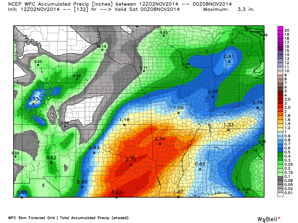
Latest Rainfall Forecast

Can we expect severe thunderstorms over the next 24 to 48 hours? Remember that a severe thunderstorm is defined as a thunderstorm that produces 58 mph winds or higher, quarter size hail or larger, and/or a tornado.
Severe weather is not going to be a concern through Tuesday.
Thunderstorm threat level is zero.


Will I need to take action?
Umbrellas will be in order on Tuesday.

Please visit your local National Weather Service Office by clicking here. The National Weather Service Office, for our region, is located in Paducah, Kentucky.

Nothing major in the extended forecast. A series of cold fronts will push through the region during the new work week. A few rain showers may linger into Wednesday.
Temperatures will likely remain below normal into next weekend. The warmest day will likely be on Monday and Tuesday (ahead of the next cold front).
I am not tracking any extreme weather through next weekend.
The six to ten day temperature outlook (November 7th through November 11th) – odds favor temperatures to be below normal.
Normal high temperatures are around 65 degrees.
Normal low temperatures for this time of the year are around 43 degrees.
The second map indicates that below normal precipitation is expected November 7th through November 11th.


Current tower cam view from the Weather Observatory- Click here for all cameras.

Southern Illinois Weather Observatory
WPSD TV 6 has a number of tower cameras. Click here for their tower camera page
& Kentucky Road Conditions & Kentucky Highway and Interstate Cameras

Downtown Paducah, Kentucky
Benton, Kentucky Tower Camera – Click here for full view

Benton, Kentucky
WSIL TV 3 has a number of tower cameras. Click here for their tower camera page
& Illinois Road Conditions

Marion, Illinois

You can sign up for my AWARE email by clicking here I typically send out AWARE emails before severe weather, winter storms, or other active weather situations. I do not email watches or warnings. The emails are a basic “heads up” concerning incoming weather conditions.