
This forecast update covers far southern Illinois, far southeast Missouri, and far western Kentucky. See the coverage map on the right side of the blog.
If you find value in this page and the other weather products on the Weather Observatory web-site then consider making a donation to keep everything up and running. It does cost quite a bit of money each month to run the radars, data feeds, hosting of sites, and more. You can give by visiting our donation page.
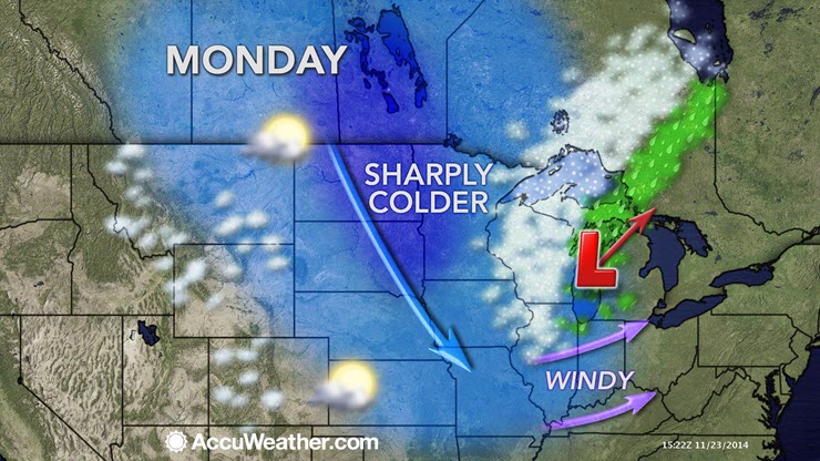
Monday – Intervals of clouds. Gusty winds will make it feel cooler than it is. A chance for a shower or sprinkle. Strong winds will gust in excess of 35 mph. High temperatures will occur during the morning hours. Temperatures will fall into the 40’s during the afternoon with wind chills in the 30’s. West winds at 15-35 mph during the morning into the early afternoon hours. Winds should start to die down a bit during the afternoon and evening hours.
Morning School Bus Stop Weather – Some clouds. Small chance for a shower. Very windy. Temperature will be around 50 degrees.
Afternoon School Bus Stop Weather – A few clouds. Cooler. Temperatures at the bus stop will be around 45 degrees. West winds at 10-20 mph.
Monday night – Clearing sky conditions and chilly. Winds will die down. Low temperatures in the upper 20’s and lower 30’s. West winds at 5-10 mph.
Tuesday – Coat weather during the morning hours. Mostly sunny and cold for November. Temperatures will be well below normal. Highs will top out only in the 40’s. Northwest winds at 10-15 mph.
Tuesday night – Just a few clouds, otherwise mostly clear conditions early in the night. Increasing clouds towards morning. Cold. Low temperatures in the 20’s. East winds at 10 mph.
Wednesday – Increasing clouds. A chance for some light rain showers. I can’t rule out some snow mixed in over our far northern counties – perhaps north of the area I concentrate my forecast on. Cool for November. High temperatures will be in the middle 40’s. Southwest winds at 10 mph.

An explanation of what is happening in the atmosphere over the coming days.
Did you know you can subscribe to the blog? When a weather event is moving into the area then I will send out an email reminder to check the blog for updates. To subscribe to the blog look on the right side of the page – down a bit. You will see this image (this is just an example, so don’t click on the subscribe button here)
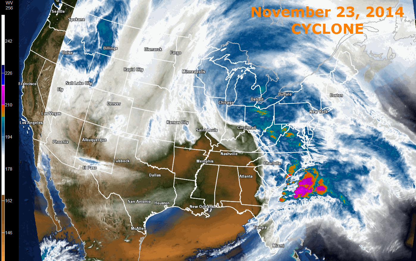
A powerful storm system is pulling into the Great Lakes this morning. Here is the satellite view last night showing the Mid-Latitude Cyclone. The clouds extend from Canada all the way to the Gulf of Mexico. Very large system. Lot of moisture.

A rapidly intensifying area of low pressure pushed out of Missouri overnight into Illinois. This low pressure system, coupled with a system from the Gulf of Mexico, was responsible for our wet weather on Sunday. Widespread rain soaked the region with 0.50″-1.00″ of rain. Some spots picked up more than 1″ of rain. A soaking fall rain.
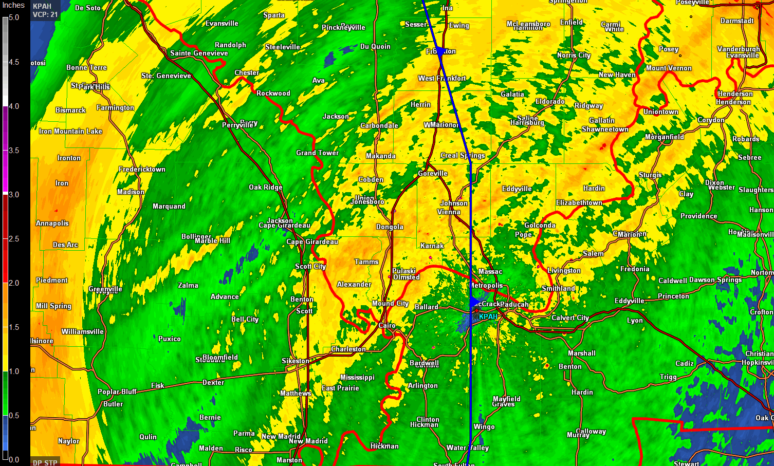
Officially at the Weather Observatory I recorded 1.06″ of rain.
Here is the radar estimated rainfall totals. The scale is on the left side of the image.
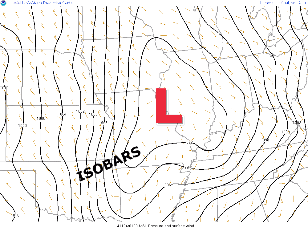
As the low deepened overnight the gradient tightened up. This produced gradient winds over our region. Gradient winds happen when the isobars around the area of low pressure (equal lines of pressure) tighten up. The closer they are packed together the stronger the winds at the surface.
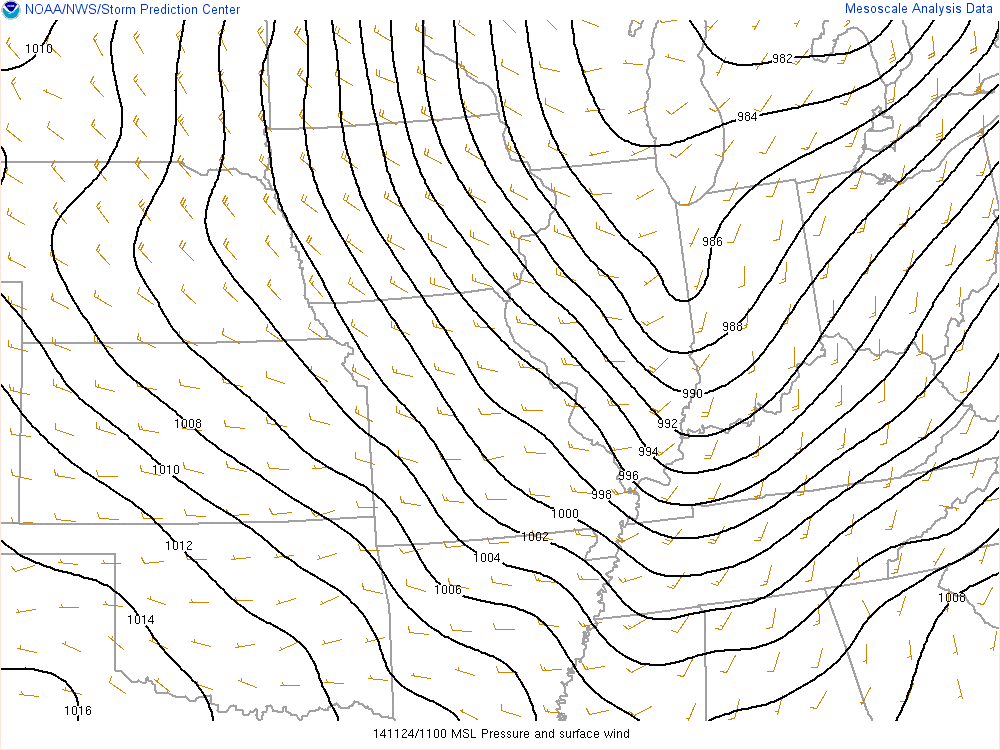
Let’s take a look at the area of low pressure as it appeared at 8 pm last night. You can see the low over Missouri. At 8 pm the low was entering Illinois. It was starting to deepen and intensify. Let’s compare it to this mornings weather map. You can see the low has pushed into the Great Lakes (deeper and more tightly packed isobars)
The 8 PM Sunday night placement of the low (see those tightly packed isobars – black lines).
This mornings map showing the low over the Great Lakes and tight isobars over our region
The winds will dry everything out today.
Current wind speeds

The winds will also usher in colder than normal temperatures. Go figure. It is almost like a broken record. November is going to go down in the books as one of the colder November’s on record.
Current temperatures show the cooler air already moving into the region

Speaking of temperatures, let’s compare temperatures from yesterday to what is coming down the pike on Tuesday.
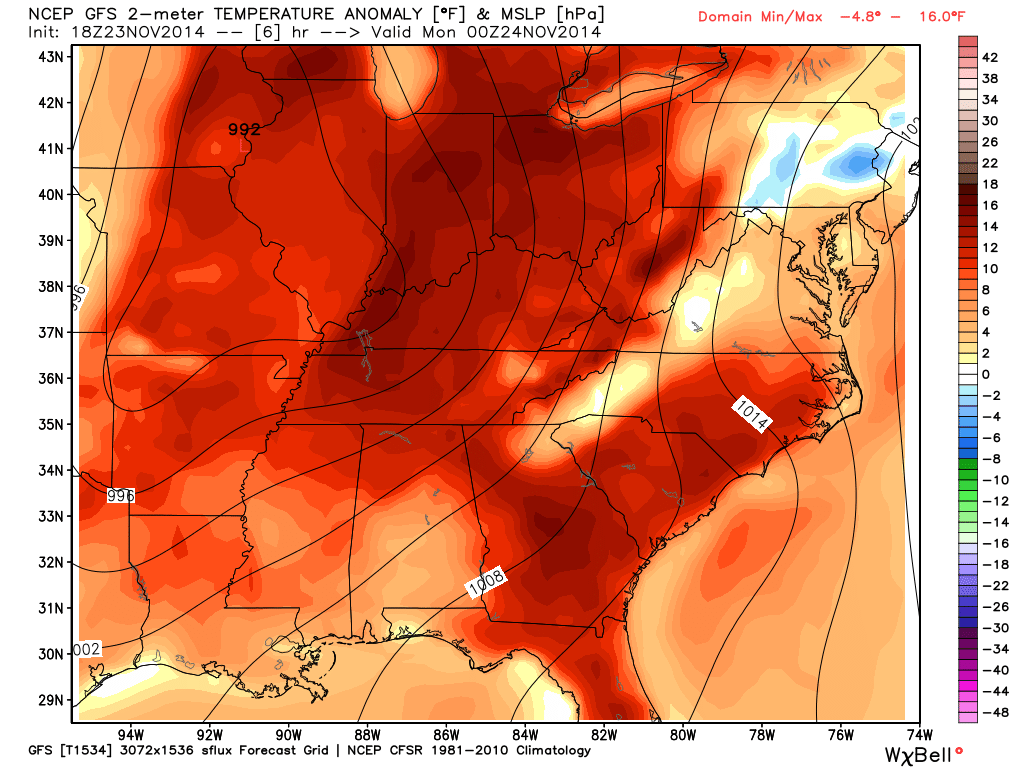
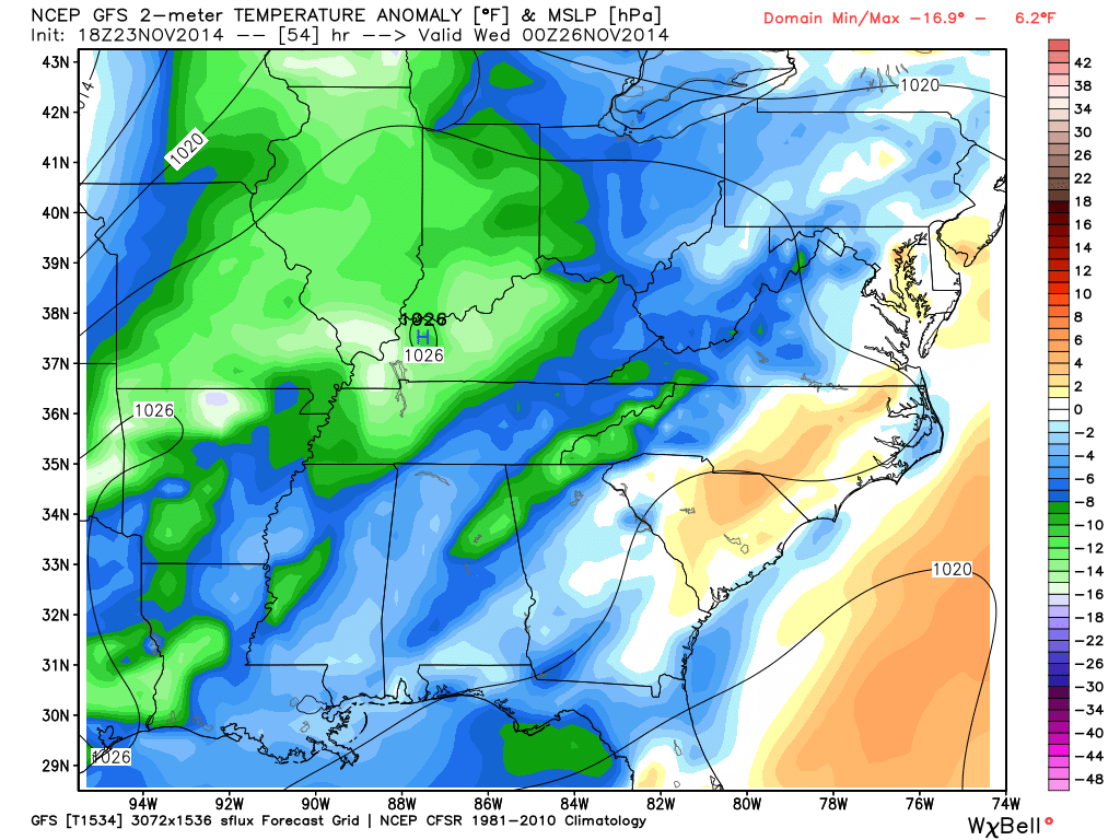
Graphics from www.weatherbell.com
Check out the difference between Sunday afternoon and what is to come on Tuesday afternoon. ALL that red on Sunday represents ABOVE normal temperatures. The blue and green on Tuesday – you guessed it 🙂 BELOW normal temperatures. Another cold shot.
SUNDAY’S ANOMALY’S – temperatures were well above normal values (normal highs for this time of the year are around 55 degrees)
NOW TUESDAY – the scale is on the right side of the page. Again, this is how many degrees below normal temperatures will be on Tuesday afternoon. Normal high temperatures for this time of the year are around 55 degrees.

No major changes. I adjusted temperatures slightly. I lowered precipitation chances for today. Appears most of the moisture is on the way out. Otherwise, the forecast is on track.
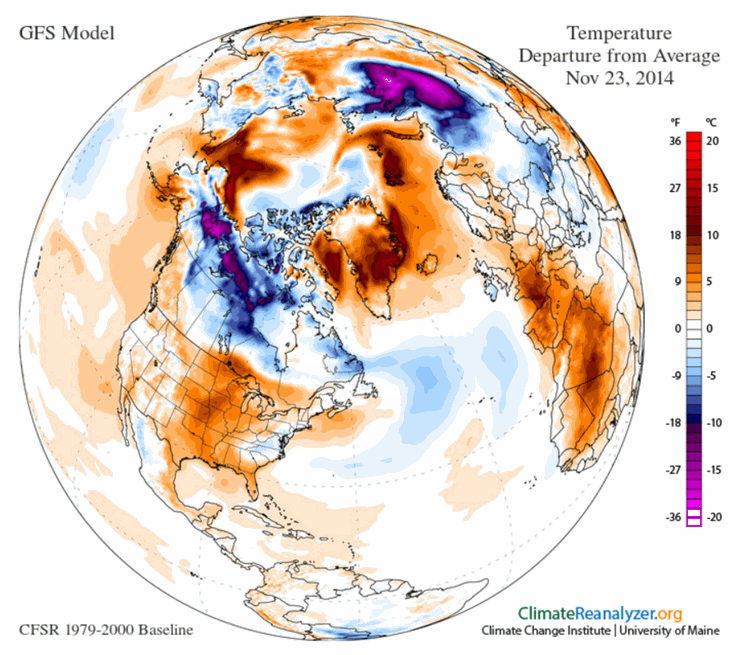
Remember last week when I showed you the global view with all the below normal temperatures across the Eastern United States? Talk about changes! Sunday brought widespread above normal temperatures over the eastern half of the nation. This was in response to our large Mid-Latitude Cyclone
Here is the world map for Sunday (anomaly map- showing where temps are above or below normal)

Windy conditions this morning. We may see some gusts above 35 mph. No other concerns through Wednesday.

The Wild Card gives you an idea of what might change that would cause the forecast to bust. A busted forecast means a forecast that does not verify. For example, if a winter storm (the area of low pressure) shifts its track 50 miles further south than expected, then that could cause a dramatic change in how much snow might or might not accumulate.
Wild card in this forecast – whether or not a few showers or sprinkles might develop on Wednesday. A weak system will move to our north. This system will likely leave most of our region dry. The NWS has included the mention of a few showers. I mentioned the same…but don’t be surprised if it is mostly a dry day. I will look over today’s data and adjust the forecast if needed.

Can we expect severe thunderstorms over the next 24 to 48 hours? Remember that a severe thunderstorm is defined as a thunderstorm that produces 58 mph winds or higher, quarter size hail or larger, and/or a tornado.
Thunderstorm threat level is zero. No severe weather concerns through Friday.

Will I need to take action?
No.

Please visit your local National Weather Service Office by clicking here. The National Weather Service Office, for our region, is located in Paducah, Kentucky.

How much rain should this system produce over our region?
Small chance for light rain on Wednesday. Most areas will likely remain dry. I will continue to monitor it for you.

Winter weather is not expected through Tuesday night. Sorry kids!
There could be some light snow/rain mix on Wednesday. Does not appear to be a big deal.

Nothing major to talk about for your holiday week ahead. A few showers perhaps on Wednesday – maybe even some light snow further north over parts of Illinois and Indiana (north of our local counties).
Thursday will be dry and cool. No major travel problems in our area.
I am watching for precipitation chances next weekend. A lot of uncertainty surrounds that system. It appears most of this week will be on the calm side. So, let’s enjoy it!
The weekend system will need to be monitored for an overrunning setup. Occasionally this can result in mixed precipitation for our region. I will be watching the Sunday into Tuesday time frame.
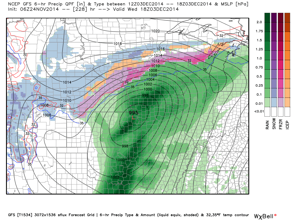
The first week of December could bring stormy conditions. Precipitation chances may go up quite a bit.
Here is the high resolution GFS for the storm in the long range. The data has been picking up on this system for awhile. If true, this would be a warm system for our region. Thunderstorms? We have a plenty of time to see how that one unfolds.
Current tower cam view from the Weather Observatory- Click here for all cameras.

Southern Illinois Weather Observatory

The Weather Observatory

Southern Illinois Weather Observatory
WSIL TV 3 has a number of tower cameras. Click here for their tower camera page & Illinois Road Conditions

Marion, Illinois
WPSD TV 6 has a number of tower cameras. Click here for their tower camera page & Kentucky Road Conditions & Kentucky Highway and Interstate Cameras

Downtown Paducah, Kentucky
Benton, Kentucky Tower Camera – Click here for full view

Benton, Kentucky

I24 Paducah, Kentucky

I24 Mile Point 9 – Paducah, KY

I24 – Mile Point 3 Paducah, Kentucky

You can sign up for my AWARE email by clicking here I typically send out AWARE emails before severe weather, winter storms, or other active weather situations. I do not email watches or warnings. The emails are a basic “heads up” concerning incoming weather conditions.
If you enjoy this blog and you live down in Alabama then check out the ABC 33/40 Blog. This blog was inspired by their blog.
Alabama Weather Blog