
This forecast update covers far southern Illinois, far southeast Missouri, and far western Kentucky. See the coverage map on the right side of the blog.
If you find value in this page and the other weather products on the Weather Observatory web-site then consider making a donation to keep everything up and running. It does cost quite a bit of money each month to run the radars, data feeds, hosting of sites, and more. You can give by visiting our donation page.
Sunday – Showers and thunderstorms likely. A few storms could produce gusty winds and heavy rain. High temperatures around 60 degrees. Southeast winds at 10-20 mph.
Sunday night – Cloudy with a chance for a few showers. Windy. Rising temperatures. Low temperatures in the 50’s. South winds at 10-20 mph…gusty. Winds turning more out of the southwest late at 10-25 mph. Gusty winds.
Monday – Mostly cloudy with a few showers. Cooler. Windy. Highs around 50 and then falling as the day wears on. West/southwest winds at 10-25 mph. Winds will gust above 30 mph at times.
Monday night – Clearing sky conditions. Winds subsiding as the evening wears on. Low temperatures from 28 to 32 degrees. West winds at 10-15 mph weakening to northwest winds at 5-10 mph.
Tuesday – Mostly sunny and cold. High temperatures only in the 40’s.

An explanation of what is happening in the atmosphere over the coming days.
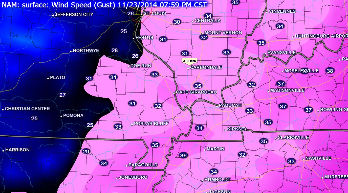
A strong storm system will push into Missouri today. This area of low pressure will deepen as it pushes into Illinois tonight. The tight pressure gradient associated with this low will cause winds to pick up today and last into Monday. Expect winds gusting above 30 mph at times
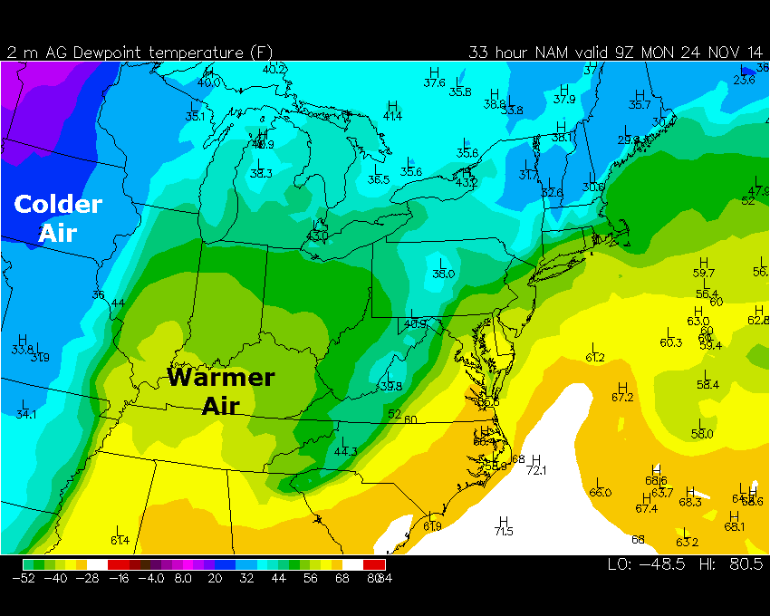
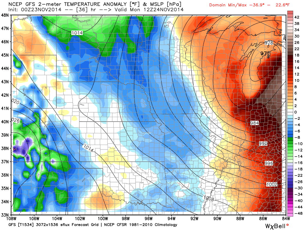
You can see the surge of warmer temperatures associated with the area of low pressure moving towards our region. Remember that a lot rotates counter-clockwise. It pulls warm air northward (for those on the right side of the low).

Widespread showers and thunderstorms will accompany this system. The best chance for locally heavy rain and gusty thunderstorms will be today into this evening. After that time period we can expect periods of showers that will last into Monday.
The Weather Observatory has numerous radars available for you to track the precipitation as it moves through the region. If you notice a radar not working then switch to one of the other ones. We have multiple sources for radar data.
WEATHER RADAR PAGE – Click here —
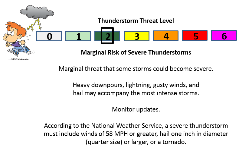
The threat for severe weather is minimal. The missing ingredient for severe weather is instability. With that said, the wind fields are very strong with this particular event (winds aloft). There is quite a bit of shear. If we had more instability then I would be quite concerned about the tornado threat. As it stands, it appears that instability will be the limiting factor that keeps us from experiencing a severe weather outbreak.
A few of the storms pushing up from Tennessee could produce gusty winds as the enter Kentucky. There is only a small chance for a thunderstorm becoming severe. If you have concerns then monitor NOAA Weather Radio and local media. It does appear the severe weather risk is minimal.
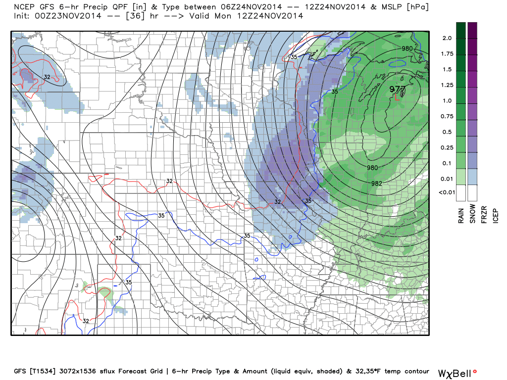
Rainfall totals of 0.50″-1.00″ are expected across the region between now and Monday afternoon. Some locally heavier downpours are likely to occur.
A cold front will push through the region later tonight into Monday. This front will usher in below normal temperatures. This should last right on through the week and perhaps into next weekend.
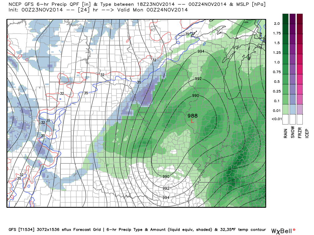
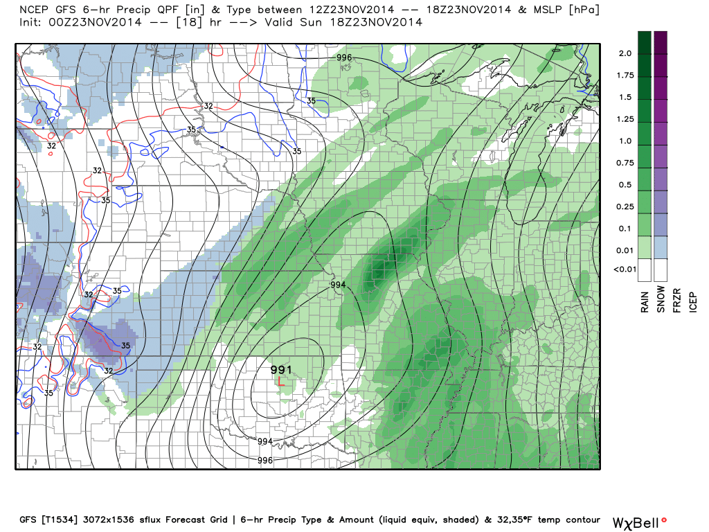
Let’s take a look at that big area of low pressure (the red L) that is going to wind up to our west and northwest today into Monday morning. You can see it pulling through Oklahoma and then into Missouri. See those lines wrapping around the storm? Those are equal lines of pressure also known as isobars. When you see those lines tightly packed together you can expect gusty winds.
The green on the map represents rain. The blue on the map represents snow.
SUNDAY AFTERNOON WEATHER MAP
SUNDAY EVENING WEATHER MAP

MONDAY MORNING AT 1 AM – WEATHER MAP – The low is pushing just north of Chicago.
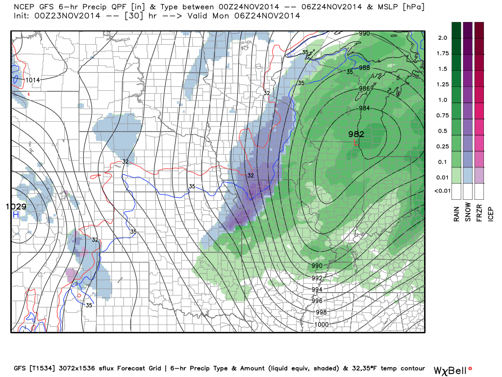
7 AM MONDAY MORNING WEATHER MAP
Let’s take a look at some of the wind gusts that are possible tonight into Monday. This is because of the tight pressure gradient around the area of low pressure.
8 PM Tonight – (below) Wind Speed (Gust) Forecast
8 AM Monday Morning (below) Wind Speed (Gust) Forecast
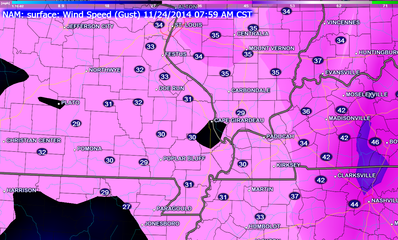

I have updated the wind speeds through Monday. Gusty winds are likely to continue into Monday morning. I also tweaked the high and low temperatures by a degree or two.
No other significant changes in the forecast have been made.

The main concern today will be gusty thunderstorms and heavy downpours. The overall threat for severe weather is mitigated because of the lack of instability. If instability was stronger then we would expect a few damaging wind reports and/or tornadoes. We are fortunate that this system does not have more instability to work with.
Monitor updates as we push through the day. Right now the concerns are limited.

The Wild Card gives you an idea of what might change that would cause the forecast to bust. A busted forecast means a forecast that does not verify. For example, if a winter storm (the area of low pressure) shifts its track 50 miles further south than expected, then that could cause a dramatic change in how much snow might or might not accumulate.
Wild card in this forecast – the wild card in this forecast will center around the timing of the cooler air on Monday. A cold front will push through the region during the morning hours. Expect high temperatures on Monday to occur early in the day. Falling temperatures are likely during the afternoon hours.
You can see on the NAM model that the cooler/drier air is pushing into southeast Missouri around daybreak on Monday. The blue colors represent lower dew points. The brighter colors are higher dew points.
You can also see on this map where the front is expected to be on Monday morning. The red shaded area represents above normal temperatures. The blue shaded area represents below normal temperatures.
You can see the red area pushing out of our region and the blue area is pushing into our region.

Can we expect severe thunderstorms over the next 24 to 48 hours? Remember that a severe thunderstorm is defined as a thunderstorm that produces 58 mph winds or higher, quarter size hail or larger, and/or a tornado.
There is only a small risk for a severe thunderstorm today. The main concern would be near the Kentucky and Tennessee border counties – more towards the Land Between the Lakes. There is a lot of spin in the atmosphere, but there is very limited instability. Overall, I believe the threat for severe weather is limited.

Will I need to take action?
An umbrella will be in order over the next 24-36 hours.

Live Lightning Data – zoom and pan: Click here
Live Lightning Data with sound (click the sound button on the left side of the page): Click here

Please visit your local National Weather Service Office by clicking here. The National Weather Service Office, for our region, is located in Paducah, Kentucky.

How much rain should this system produce over our region?
Widespread rainfall totals of 0.50″-1.00″ of rain are expected. Locally heavier totals are possible.

Winter weather is not expected through Tuesday. Sorry kids!

Cooler air returns early in the new workweek. The cooler air should last into next weekend. There is some debate about temperatures on Friday into next Sunday.
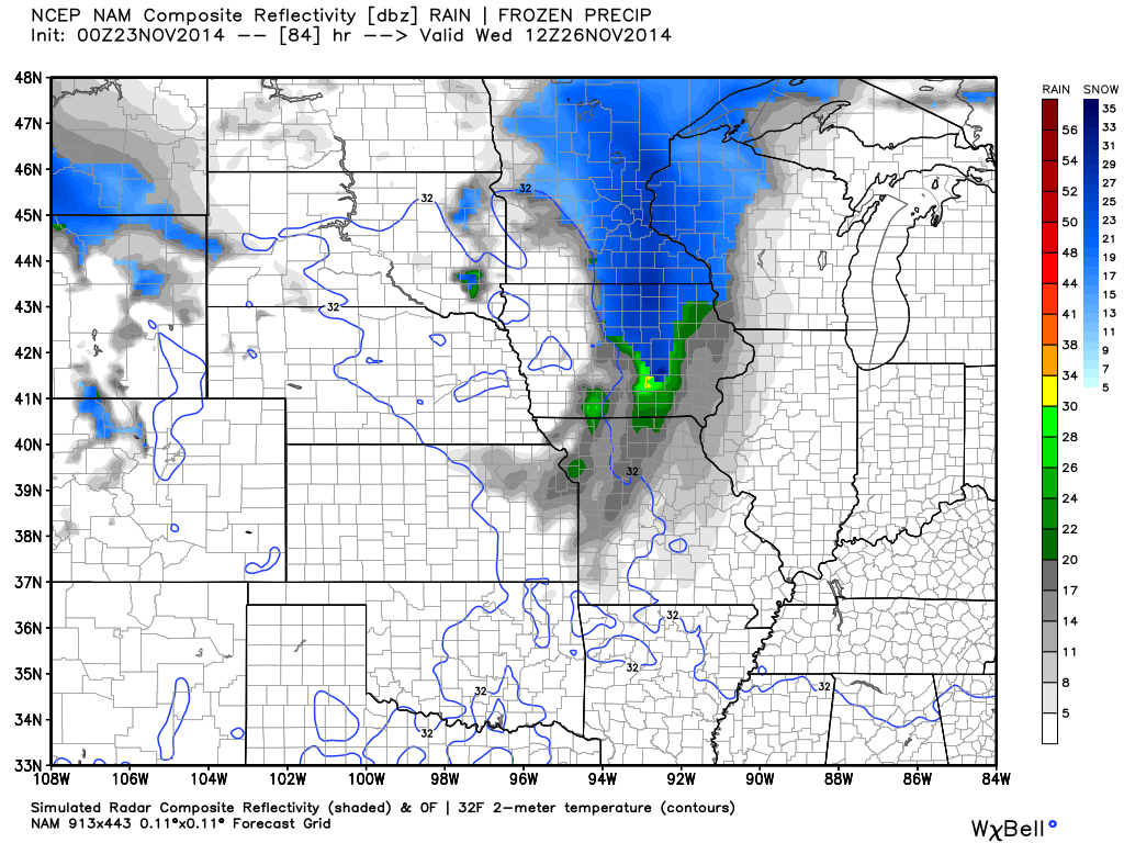
A weak system could produce some clouds on Wednesday. This, however, appears to be tracking so far north that it should not be a concern.
This is what the weather map shows on Wednesday. You can see a clipper diving down out of Canada towards the Great Lakes. Perhaps some increase of clouds over our region because of this system. Also this might help cool temperatures even more.
The blue colors represent snow – the green indicates some light rain.
I will be monitoring late next weekend for additional precipitation chances. Too far out for any certainty.
![]()
We have regional radars and local city radars – if a radar does not seem to be updating then try another one. Occasional browsers need their cache cleared. You may also try restarting your browser. That usually fixes the problem. Occasionally we do have a radar go down. That is why I have duplicates. Thus, if one fails then try another one.
If you have any problems then please send me an email beaudodson@usawx.com
WEATHER RADAR PAGE – Click here —
We also have a new national interactive radar – you can view that radar by clicking here.
Local interactive city radars include St Louis, Mt Vernon, Evansville, Poplar Bluff, Cape Girardeau, Marion, Paducah, Hopkinsville, Memphis, Nashville, Dyersburg, and all of eastern Kentucky – these are interactive radars. Local city radars – click here
NOTE: Occasionally you will see ground clutter on the radar (these are false echoes). Normally they show up close to the radar sites – including Paducah.

Regional Radar – Click on radar to take you our full radar page.


Regional Radar

Current WARNINGS (a warning means take action now). Click on your county to drill down to the latest warning information. Keep in mind that there can be a 2-3 minute delay in the updated warning information.
I strongly encourage you to use a NOAA Weather Radio or warning cell phone app for the most up to date warning information. Nothing is faster than a NOAA weather radio.


Current tower cam view from the Weather Observatory- Click here for all cameras.

Southern Illinois Weather Observatory

The Weather Observatory

Southern Illinois Weather Observatory
WSIL TV 3 has a number of tower cameras. Click here for their tower camera page & Illinois Road Conditions

Marion, Illinois
WPSD TV 6 has a number of tower cameras. Click here for their tower camera page & Kentucky Road Conditions & Kentucky Highway and Interstate Cameras

Downtown Paducah, Kentucky
Benton, Kentucky Tower Camera – Click here for full view

Benton, Kentucky

I24 Paducah, Kentucky

I24 Mile Point 9 – Paducah, KY

I24 – Mile Point 3 Paducah, Kentucky

You can sign up for my AWARE email by clicking here I typically send out AWARE emails before severe weather, winter storms, or other active weather situations. I do not email watches or warnings. The emails are a basic “heads up” concerning incoming weather conditions.