We have some great sponsors for the Weather Talk Blog. Please let our sponsors know that you appreciate their support for the Weather Talk Blog.
Milner and Orr Funeral Home and Cremation Services located in Paducah, Kentucky and three other western Kentucky towns – at Milner and Orr they believe in families helping families. You can find Milner and Orr on Facebook, as well.
![]()
.

Wortham Dental Care located in Paducah, Kentucky. The gentle dentist. Mercury free dentistry. They also do safe Mercury removal. You can find Wortham Dental Care on Facebook, as well
.

For all of your families eye care needs. Visit their web-site here. Or, you can also visit their Facebook page.
.

Endrizzi’s Storm Shelters – For more information click here. Endrizzi Contracting and Landscaping can be found on Facebook, as well – click here
.

Best at Enabling Body Shop Profitability since 1996. Located In Paducah Kentucky and Evansville Indiana; serving all customers in between. They provide Customer Service, along with all the tools necessary for body shops to remain educated and competitive. Click the logo above for their main web-site. You can find McClintock Preferred Finishes on Facebook, as well
.

Duck/goose decoys? Game calls? Optics? We have you covered! Click the logo above or visit Final Flight on Facebook, as well.

This forecast update covers far southern Illinois, far southeast Missouri, and far western Kentucky. See the coverage map on the right side of the blog.
Remember that weather evolves. Check back frequently for updates, especially during active weather.
Sunday night – Mostly clear. Cold.
Temperatures: Lows in the upper 20s
Winds: South winds at 0-5 mph
What is the chance for precipitation? 0%
Coverage of precipitation? None
My confidence in this part of the forecast verifying is High
Should I cancel my outdoor plans? No
Is severe weather expected? No
What impact is expected? Frost/freeze likely
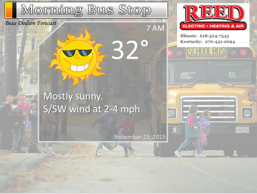
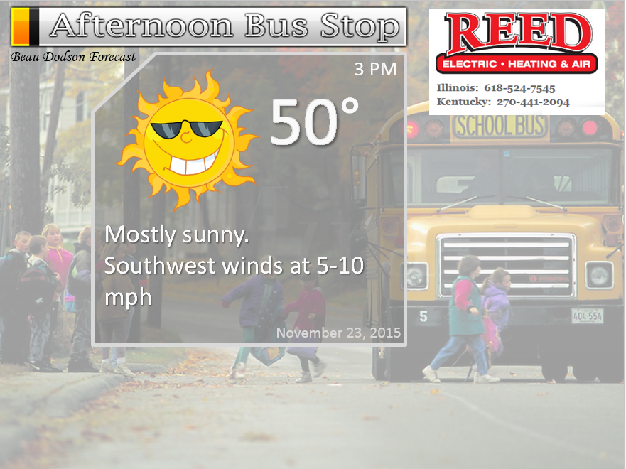
Monday – Partly to mostly sunny. Not as cold.
Temperatures: Highs in the upper 40s to lower 50s.
Winds: South and southwest winds at 4-8 mph.
What is the chance for precipitation? 0%
Coverage of precipitation? None
My confidence in this part of the forecast verifying is High
Should I cancel my outdoor plans? No
Is severe weather expected? No
What impact is expected? None
Monday night – Mostly clear and cold.
Temperatures: Lows in the lower 30s
Winds: Light winds from the south/southwest
What is the chance for precipitation? 0%
Coverage of precipitation? None
My confidence in this part of the forecast verifying is High
Should I cancel my outdoor plans? No
Is severe weather expected? No
What impact is expected? None
Tuesday – Some clouds possible. A little warmer.
Temperatures: Highs in the lower to middle 50s
Winds: Light winds
What is the chance for precipitation? 0%
Coverage of precipitation? None
My confidence in this part of the forecast verifying is High
Should I cancel my outdoor plans? No
Is severe weather expected? No
What impact is expected? None
Tuesday night – Partly cloudy
Temperatures: Lows in the 36 to 42 degree range
Winds: Light winds
What is the chance for precipitation? 0%
Coverage of precipitation? None
My confidence in this part of the forecast verifying is High
Should I cancel my outdoor plans? No
Is severe weather expected? No
What impact is expected? None
Wednesday – Mix of sun and clouds
Temperatures: Highs in the middle 50s
Winds: South winds at 10 mph
What is the chance for precipitation? 0%
Coverage of precipitation? None
My confidence in this part of the forecast verifying is High
Should I cancel my outdoor plans? No
Is severe weather expected? No
What impact is expected? None
Wednesday night – Increasingly cloudy sky conditions.
Temperatures: Lows in the middle 40s
Winds: South winds at 10 mph
What is the chance for precipitation? 20%
Coverage of precipitation? None
My confidence in this part of the forecast verifying is medium
Should I cancel my outdoor plans? No
Is severe weather expected? No
What impact is expected? None
Thanksgiving – Cloudy. A small chance for showers, especially late in the day. Better chances over our far western counties of southeast Missouri
Temperatures: Highs in the upper 50s to around 60 degrees
Winds: South winds at 10-20 mph.
What is the chance for precipitation? 30% (subject to adjustments as we draw nearer)
Coverage of precipitation? Scattered
My confidence in this part of the forecast verifying is Low to medium
Should I cancel my outdoor plans? No, but let’s monitor updates
Is severe weather expected? No
What impact is expected? Maybe wet roadways
Thursday night – Cloudy with showers.
Temperatures: Lows in the upper 40s to lower 50s
Winds: South winds at 10 mph
What is the chance for precipitation? 60%
Coverage of precipitation? Scattered to perhaps widespread as we move through the overnight hours into Friday morning
My confidence in this part of the forecast verifying is medium
Should I cancel my outdoor plans? I would monitor updates. Rain appears likely.
Is severe weather expected? No
What impact is expected? Wet roadways
Friday – Cloudy. Rain likely.
Temperatures: Highs in the middle 50s
Winds: South/southwest winds at 6-12 mph.
What is the chance for precipitation? 70%
Coverage of precipitation? Widespread
My confidence in this part of the forecast verifying is Medium
Should I cancel my outdoor plans? Better monitor updates. Rain appears likely.
Is severe weather expected? No
What impact is expected? Wet roadways
Friday night – Cloudy with rain possible/likely
Temperatures: Lows in 40s
Winds: Southwest winds at 10 mph
What is the chance for precipitation? 70%
Coverage of precipitation? Widespread rain possible
My confidence in this part of the forecast verifying is Medium
Should I cancel my outdoor plans? Perhaps. Rain is likely in the region.
Is severe weather expected? No
What impact is expected? Wet roadways.
Saturday – Cloudy. Maybe some showers. Low confidence.
Temperatures: Highs in the upper 40s to lower 50s
Winds: West at 6-12 mph
What is the chance for precipitation? 30% (subject to adjustments as we draw nearer)
Coverage of precipitation? Scattered
My confidence in this part of the forecast verifying is Low
Should I cancel my outdoor plans? No, but let’s monitor updates
Is severe weather expected? No
What impact is expected? Wet roadways if the rain does develop
Rain likely Thursday night – Saturday.
Click their ad below to visit their web-site or click here reedelec.com


![]()


Don’t forget to check out the Southern Illinois Weather Observatory web-site for weather maps, tower cams, scanner feeds, radars, and much more! Click here

An explanation of what is happening in the atmosphere over the coming days…
Highlights
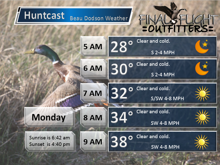
1. Cold Sunday night and Monday morning.
2. Moderating trend for temperatures this week
3. Great travel weather Monday-Thursday
4. Rain chances increase late on Thursday into Friday
5. Another possible rain maker this weekend, but lower confidence
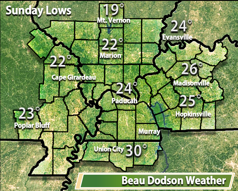
Temperatures did not drop as much as expected on Saturday night. There were a few upper teens over northern parts of southeast Missouri and southern Illinois. Which, was my original forecast. I should have stuck with that. I ended up dropping it by a few degrees. In the end we mostly were in the 20s. Cold.
Here were some of the Sunday morning lows (temperatures may vary from one backyard to the next)
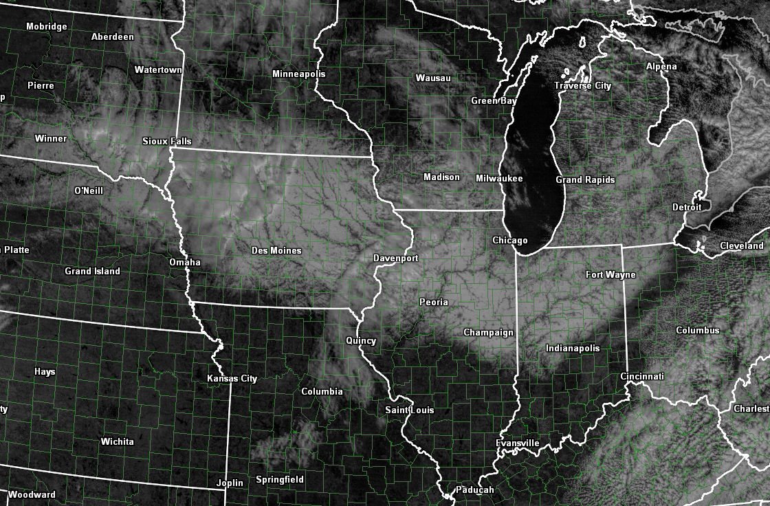
Did you hear about the snow that fell to our north on Friday/Saturday? Check out this visible satellite image. It is actually picking up on the snow cover. Can you find it? Can you see the rivers? Click the image for a larger view.
A look ahead…
Monday morning will deliver more 20s to the region.
The good news is that this cold snap is short lived. Temperatures will already start to rebound as we move into Monday afternoon – Thursday. This, as winds turn around from the south. Southerly winds will mean rising temperatures. Nothing extreme, but certainly warmer than it has been this past weekend.
What happens when our winds turn southerly in the fall and winter? Yep! If you guessed rain then you win. Rain chances enter the picture by Thursday evening and will linger into Friday night. Another storm may take shape on Saturday and Sunday, but confidence is low on that happening.
Let’s look at your travel forecast for the Missouri and Ohio Valleys.
Monday – great travel conditions
Tuesday – great travel conditions
Wednesday and Wednesday night – great travel conditions
Thursday morning and afternoon – great travel conditions. Some rain possible over western Missouri into Iowa. Right now, subject to changes, our region should remain mostly dry through Thursday afternoon. Some of the data attempts to bring showers into our western counties of southeast Missouri on Thursday morning and afternoon. I will update as we move forward. Rain would be light (if it occurred at all).
Friday – Rain likely area-wide. Some thunder possible.
Friday night – Rain likely and perhaps thunder. No severe weather anticipated.
Saturday-Sunday: I will be monitoring another storm system to our southwest. Some of the guidance brings more rain into our region with the system. Other data keeps it further south. Let’s monitor and update as we move forward.
How about some maps
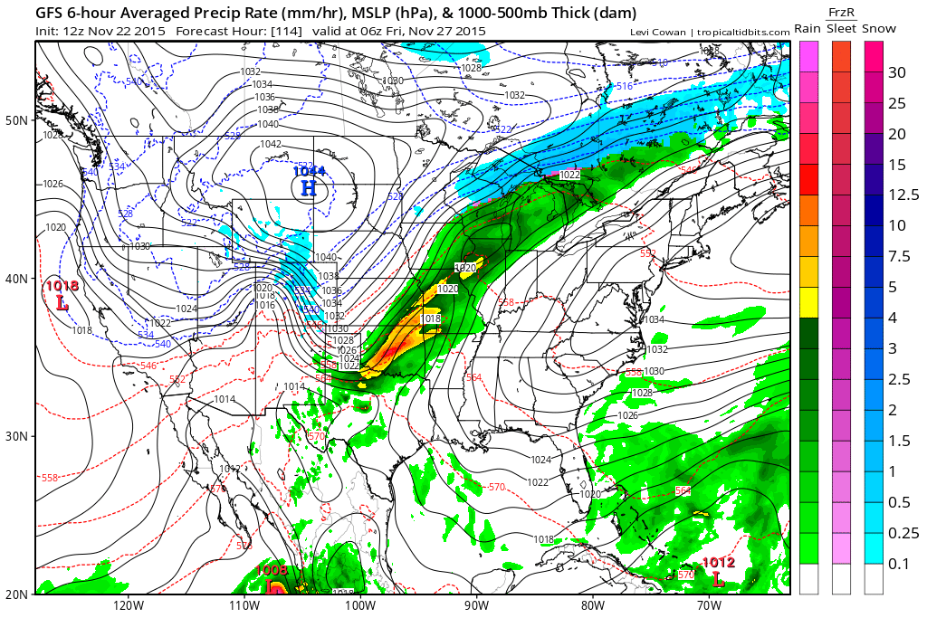
Here is the Thanksgiving rain system. Notice how the morning and afternoon hours currently appear mostly dry. No green on the map in our local area with the exception of south central Missouri.
This first map is for Thanksgiving morning at 6 am. You can see some rain showers to our west. Not sure rain makes it into our region Wednesday night or Thursday morning. However, this is still a few days away. Let’s keep an eye on it. If the system speeds up then the forecast would obviously need adjustments.
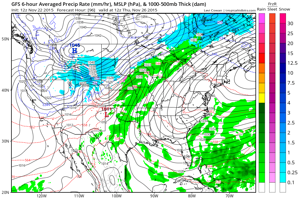
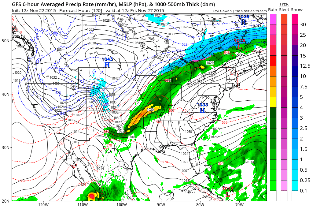
This next map (below) is for Thursday night at 6 pm. Will rain make it into our local counties that evening? It is possible. Still some time to work out the details on this part of the forecast. Rain will move in at some point Thursday night. The green represents rainfall totals for the previous six hours.

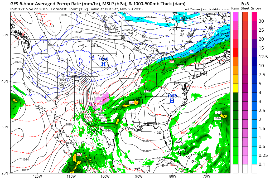
This map is for 11 pm Thursday night into the 1 am hour on Friday morning. Rain pushing further and further eastward. Still need to work out the timing for our local counties.
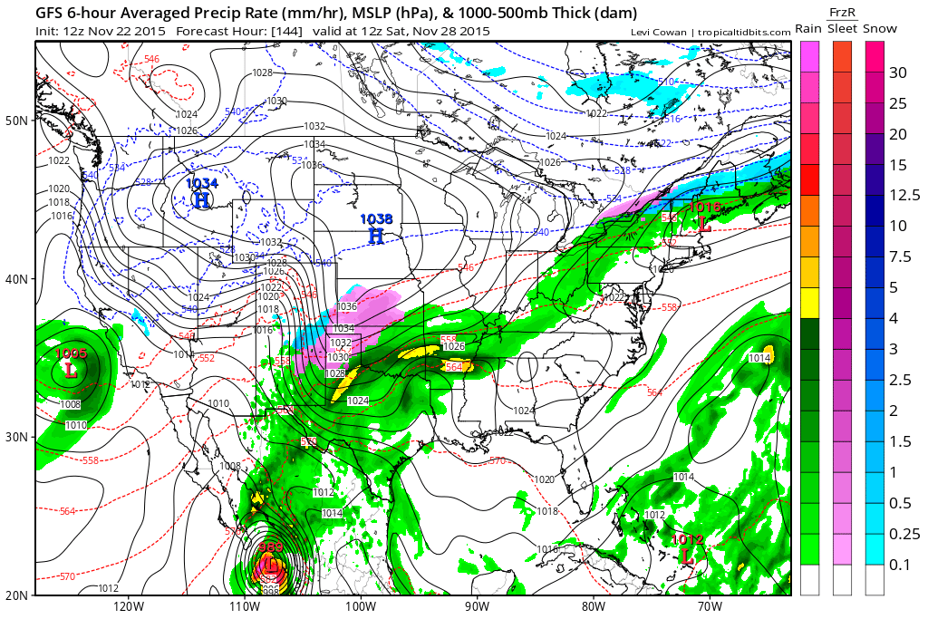
This map is Friday morning around 6 am. The rain has covered our whole region. Rain chances appear almost certain on Friday.
This map is for the 6 pm hour on Friday evening. Still some rain in our region.
This is the Saturday morning map (below). See the new storm system taking shape to our southwest? Not all guidance is picking up on this. That makes me a bit skeptical. Let’s continue to monitor the trends over the next few days. The EC model, which I generally like, takes this system just a little further south. But, still within reach.
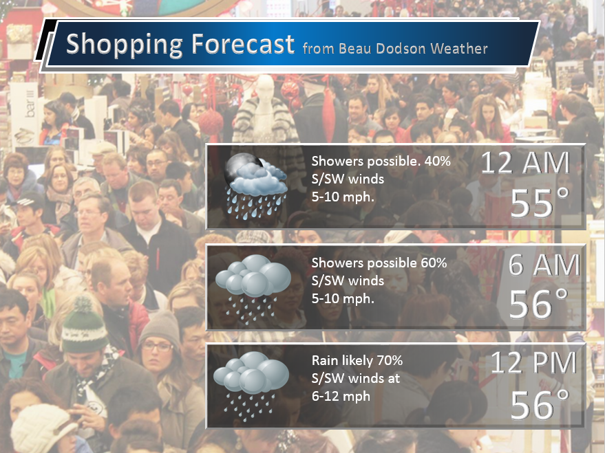
And, a little early for this forecast, but I thought I would throw it out there. Rain possible on Thursday night and especially on Friday. Might need an umbrella and jacket if you are going to stand outside of stores!
For the time being, I do not see any snow or ice in our forecast. Note that I have brought back the snow forecast to the blog. They will be updated a couple of times each day.

No snow anticipated.

No frozen precipitation through Friday.

No major changes. I continue to monitor rain chances later this week. A fine tuning of the forecast will continue to be necessary as the timing of the rains arrival is still in question.

No major concerns.

No

The wild card in the forecast, for the upcoming week, will be the timing of the rains arrival on Thursday.

Frost/freeze likely on Monday morning.

How much precipitation should we expect over the next few days?
No significant rain in the forecast through Wednesday.
The next system arrives Thursday-Saturday. Could be a decent rain event. Monitor updates.

Can we expect severe thunderstorms over the next 24 to 48 hours? Remember that a severe thunderstorm is defined as a thunderstorm that produces 58 mph winds or higher, quarter size hail or larger, and/or a tornado.
The thunderstorm threat level will be ZERO for Sunday through Wednesday.
.
Monday: Severe weather is not anticipated.
Tuesday: Severe weather is not anticipated.
Wednesday: Severe weather is not anticipated.
Thursday: Severe weather is not anticipated. Thunder Thursday night?
Friday: Severe weather is not anticipated. Thunder?
Saturday: Severe weather is not anticipated.
Sunday: Severe weather is not anticipated.


Here is the official 6-10 day and 8-14 day temperature and precipitation outlook. Check the date stamp at the top of each image (so you understand the time frame).
The forecast maps below are issued by the Weather Prediction Center (NOAA).


The latest 8-14 day temperature and precipitation outlook. Note the dates are at the top of the image. These maps DO NOT tell you how high or low temperatures or precipitation will be. They simply give you the probability as to whether temperatures or precipitation will be above or below normal.


Here are the current river stage forecasts. You can click your state and then the dot for your location. It will bring up the full forecast and hydrograph.
Click Here For River Stage Forecasts…

Who do you trust for your weather information and who holds them accountable?
I have studied weather in our region since the late 1970’s. I have 37 years of experience in observing our regions weather patterns. My degree is in Broadcast Meteorology from Mississippi State University and an Associate of Science (AS). I am currently working on my Bachelor’s Degree in Geoscience.
My resume includes:
Member of the American Meteorological Society.
NOAA Weather-Ready Nation Ambassador.
Meteorologist for McCracken County Emergency Management.
I own and operate the Southern Illinois Weather Observatory.
Recipient of the Mark Trail Award, WPSD Six Who Make A Difference Award, Kentucky Colonel, and the Caesar J. Fiamma” Award from the American Red Cross.
In 2009 I was presented with the Kentucky Office of Highway Safety Award.
Recognized by the Kentucky House of Representatives for my service to the State of Kentucky leading up to several winter storms and severe weather outbreaks.
I am also President of the Shadow Angel Foundation which serves portions of western Kentucky and southern Illinois.
There is a lot of noise on the internet. A lot of weather maps are posted without explanation. Over time you should learn who to trust for your weather information.
My forecast philosophy is simple and straight forward.
- Communicate in simple terms
- To be as accurate as possible within a reasonable time frame before an event
- Interact with you on Twitter, Facebook, and the blog
- Minimize the “hype” that you might see on television or through other weather sources
- Push you towards utilizing wall-to-wall LOCAL TV coverage during severe weather events
I am a recipient of the Mark Trail Award, WPSD Six Who Make A Difference Award, Kentucky Colonel, and the Caesar J. Fiamma” Award from the American Red Cross. In 2009 I was presented with the Kentucky Office of Highway Safety Award. I was recognized by the Kentucky House of Representatives for my service to the State of Kentucky leading up to several winter storms and severe weather outbreaks.
If you click on the image below you can read the Kentucky House of Representatives Resolution.

Many of my graphics are from www.weatherbell.com – a great resource for weather data, model data, and more


You can sign up for my AWARE email by clicking here I typically send out AWARE emails before severe weather, winter storms, or other active weather situations. I do not email watches or warnings. The emails are a basic “heads up” concerning incoming weather conditions.