We have some great sponsors for the Weather Talk Blog. Please let our sponsors know that you appreciate their support for the Weather Talk Blog.
Milner and Orr Funeral Home and Cremation Services located in Paducah, Kentucky and three other western Kentucky towns – at Milner and Orr they believe in families helping families. You can find Milner and Orr on Facebook, as well.
![]()
.

Wortham Dental Care located in Paducah, Kentucky. The gentle dentist. Mercury free dentistry. They also do safe Mercury removal. You can find Wortham Dental Care on Facebook, as well
.

For all of your families eye care needs. Visit their web-site here. Or, you can also visit their Facebook page.
.

Endrizzi’s Storm Shelters – For more information click here. Endrizzi Contracting and Landscaping can be found on Facebook, as well – click here
.

Best at Enabling Body Shop Profitability since 1996. Located In Paducah Kentucky and Evansville Indiana; serving all customers in between. They provide Customer Service, along with all the tools necessary for body shops to remain educated and competitive. Click the logo above for their main web-site. You can find McClintock Preferred Finishes on Facebook, as well
.

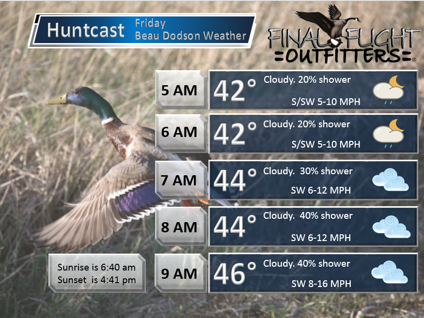
Duck/goose decoys? Game calls? Optics? We have you covered! Click the logo above or visit Final Flight on Facebook, as well.

This forecast update covers far southern Illinois, far southeast Missouri, and far western Kentucky. See the coverage map on the right side of the blog.
Remember that weather evolves. Check back frequently for updates, especially during active weather.
Friday night – Becoming cloudy. A chance for some late night showers.
Temperatures: Lows in the 36 to 44 degree range.
Winds: Northeast winds at 5 mph
What is the chance for precipitation? 0% before midnight. 30% after 3 am and 50% after 6 am
Coverage of precipitation? Towards morning scattered.
My confidence in this part of the forecast verifying is High
Should I cancel my outdoor plans? No
Is severe weather expected? No
What impact is expected? Maybe wet roadways after 3 am.
WEATHER RADAR PAGE – Click here —
Saturday – Strong wind alert. Cloudy. Showers likely in the morning. Then showers ending in the afternoon (ends west to east). Chilly. Becoming windy. Clearing sky conditions during the afternoon hours. Falling temperatures in the afternoon.
Temperatures: Highs in the 46 to 52 degree range – temperatures may fall during the afternoon hours.
Winds: Winds may start out from the southwest. Then turning north/northwest wind at 10-20 mph. Gusty winds at times. Gusts above 30 mph times.
What is the chance for precipitation? 60% in the morning tapering to 20% in the afternoon
Coverage of precipitation? Scattered to perhaps widespread for a few hours in the morning as the front pushes through the area. Light rain.
My confidence in this part of the forecast verifying is High
Should I cancel my outdoor plans? I would check radars in the morning. Not the best day developing.
Is severe weather expected? No
What impact is expected? Wet roadways.
Saturday night – Mostly clear. Cold. A freeze likely. Temperatures below 32 degrees for a prolonged period of time.
Temperatures: Lows in the lower to middle 20s. Upper teens possible over parts of southern Illinois. More northern counties vs far southern.
Winds: Northwest winds at 8 to 16 mph early in the evening and then 0-5 mph late at night
What is the chance for precipitation? 0%
Coverage of precipitation? None
My confidence in this part of the forecast verifying is High
Should I cancel my outdoor plans? No, but it will be cold.
Is severe weather expected? No
What impact is expected? Frost/freeze likely
Sunday – Mostly to partly sunny. Chilly.
Temperatures: Highs in the upper 30s and lower 40s
Winds: West winds at 4-8 mph.
What is the chance for precipitation? 0%
Coverage of precipitation? None
My confidence in this part of the forecast verifying is High
Should I cancel my outdoor plans? No
Is severe weather expected? No
What impact is expected? None
Sunday night – Mostly clear. Cold.
Temperatures: Lows in the middle 20s
Winds: North winds at 0-5 mph
What is the chance for precipitation? 0%
Coverage of precipitation? None
My confidence in this part of the forecast verifying is High
Should I cancel my outdoor plans? No
Is severe weather expected? No
What impact is expected? Frost/freeze likely
Monday – Partly to mostly sunny.
Temperatures: Highs in the upper 40s to around 50 degrees.
Winds: West winds at 4-8 mph.
What is the chance for precipitation? 0%
Coverage of precipitation? None
My confidence in this part of the forecast verifying is High
Should I cancel my outdoor plans? No
Is severe weather expected? No
What impact is expected? None
Monday night – Mostly clear and cold.
Temperatures: Lows in the lower 30s
Winds: Light winds
What is the chance for precipitation? 0%
Coverage of precipitation? None
My confidence in this part of the forecast verifying is High
Should I cancel my outdoor plans? No
Is severe weather expected? No
What impact is expected? None
Tuesday – Mostly sunny. A little warmer.
Temperatures: Highs in the lower to middle 50s
Winds: Light winds
What is the chance for precipitation? 0%
Coverage of precipitation? None
My confidence in this part of the forecast verifying is High
Should I cancel my outdoor plans? No
Is severe weather expected? No
What impact is expected? None
Tuesday night – Partly cloudy
Temperatures: Lows in the 36 to 42 degree range
Winds: Light winds
What is the chance for precipitation? 0%
Coverage of precipitation? None
My confidence in this part of the forecast verifying is High
Should I cancel my outdoor plans? No
Is severe weather expected? No
What impact is expected? None
Wednesday – Some increase in clouds.
Temperatures: Highs in the middle 50s
Winds: South winds at 10 mph
What is the chance for precipitation? 0%
Coverage of precipitation? None
My confidence in this part of the forecast verifying is High
Should I cancel my outdoor plans? No
Is severe weather expected? No
What impact is expected? None
Wednesday night – Partly cloudy.
Temperatures: Lows in the middle 40s
Winds: South winds at 10 mph
What is the chance for precipitation? 30%
Coverage of precipitation? Scattered possible
My confidence in this part of the forecast verifying is Low to medium
Should I cancel my outdoor plans? No
Is severe weather expected? No
What impact is expected? None
Thanksgiving – Cloudy. A chance for showers, especially late in the day.
Temperatures: Highs in the upper 50s
Winds: South winds at 10-20 mph.
What is the chance for precipitation? 30% (subject to adjustments as we draw nearer)
Coverage of precipitation? Scattered
My confidence in this part of the forecast verifying is Low
Should I cancel my outdoor plans? No, but let’s monitor updates
Is severe weather expected? No
What impact is expected? Maybe wet roadways
Rain likely Thursday night – Saturday.
Click their ad below to visit their web-site or click here reedelec.com


![]()


Don’t forget to check out the Southern Illinois Weather Observatory web-site for weather maps, tower cams, scanner feeds, radars, and much more! Click here

An explanation of what is happening in the atmosphere over the coming days…
Highlights
1. Mostly calm and cool weather into the weekend
2. A few showers on Saturday morning. Gusty winds on Saturday.
3. Cold for Sunday and Monday morning. Expect lows into the 20s
4. Thanksgiving rain?
A cold front will push through our region on Friday night and Saturday morning. This front will be accompanied by light showers. Rainfall totals, for most locations, will be from 0.01″-0.10″. A few pockets of 0.15-0.20″ can’t be ruled out over northern parts of southern Illinois and northwest Kentucky.
WEATHER RADAR PAGE – Click here —
Strong wind alert for Saturday.
Strong winds will develop on Saturday behind the front. Expect west/northwest winds at 15-30 mph with gusts to 40 mph possible. Not all that unusual for the fall months. Still, windy enough to cause some small issues here and there.
Much colder air will arrive with the front, as well. Expect high temperatures on Saturday to remain mostly in the 40s. Expect high temperatures on Sunday to struggle to reach 40 degrees. This is more like January air than November air.
A hard freeze will occur on Sunday morning.
There will be a little bit of moisture behind the front on Saturday and Sunday. Can’t completely rule out a snow flurry. Nothing of significance.
If you are traveling to northern Illinois or Indiana then you might check their latest forecast. Moderate to occasionally heavy snow is forecast up that way.
Here is the future-cast radar for Saturday morning at 6 am.
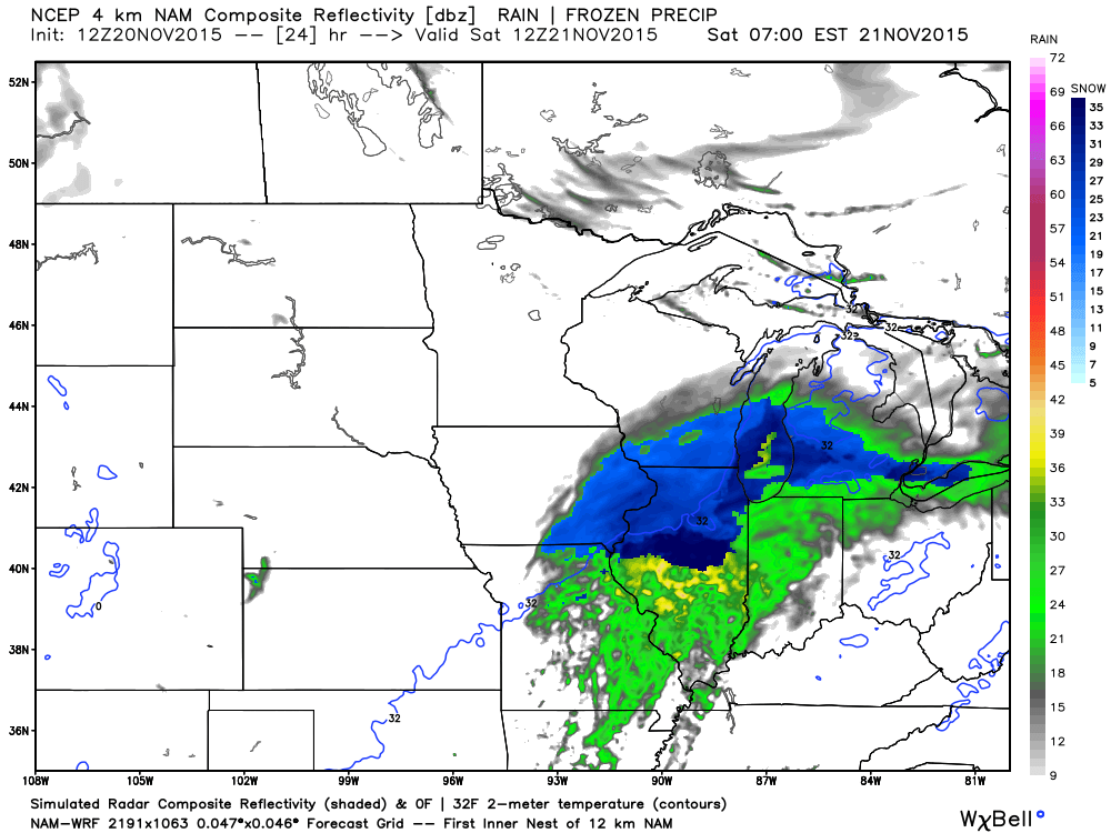
and then the radar around 12 noon. The rain will exit quickly from west to east. Again, light rain. The blue represents snow. Well to our north.

Monday morning temperatures will likely dip into the twenties, as well. Brrr
The good news is that dry weather will prevail on Sunday through at least Wednesday.
On Wednesday a new storm system will start to take shape over the Central United States. This could bring an increase in rain chances as early as Thursday. More likely, however, will be rain chances on Thursday night into Saturday. I will need to fine tune the timing as we draw closer to the event.
Southerly winds will develop ahead of this next system. That does mean warmer temperatures. We should reach back into the 50s by the middle of the week. Not too bad for Thanksgiving (temperature wise).
Some of the data shows cold air moving in behind the late week system. I will keep an eye on that, as well.
Let’s look at some maps
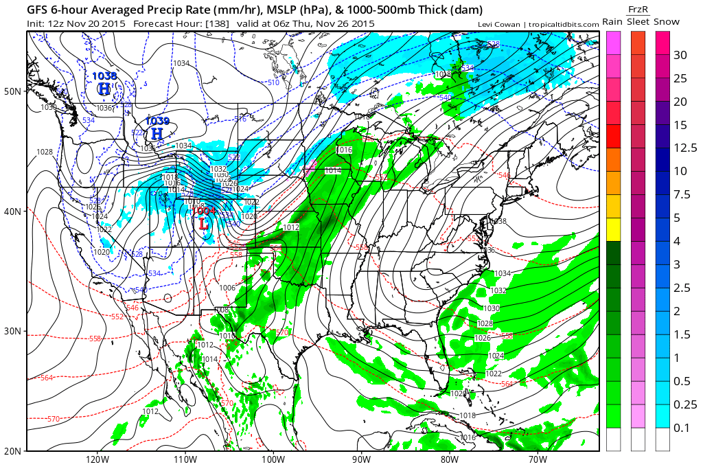
This first map (below) is for Wednesday night and Thursday morning around 1 am. Some rain to our west. Will need to see how fast the rain moves into our northwest counties. Believe Wednesday and Wednesday night should remain mostly dry.
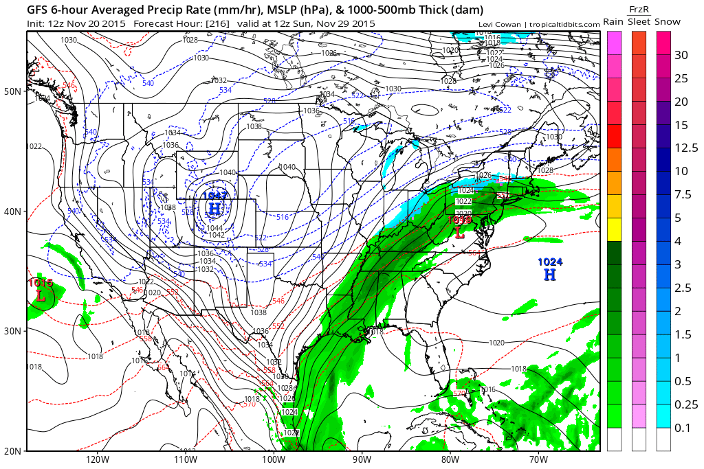
Here is the GFS maps for the Thanksgiving system. Green would be rain.
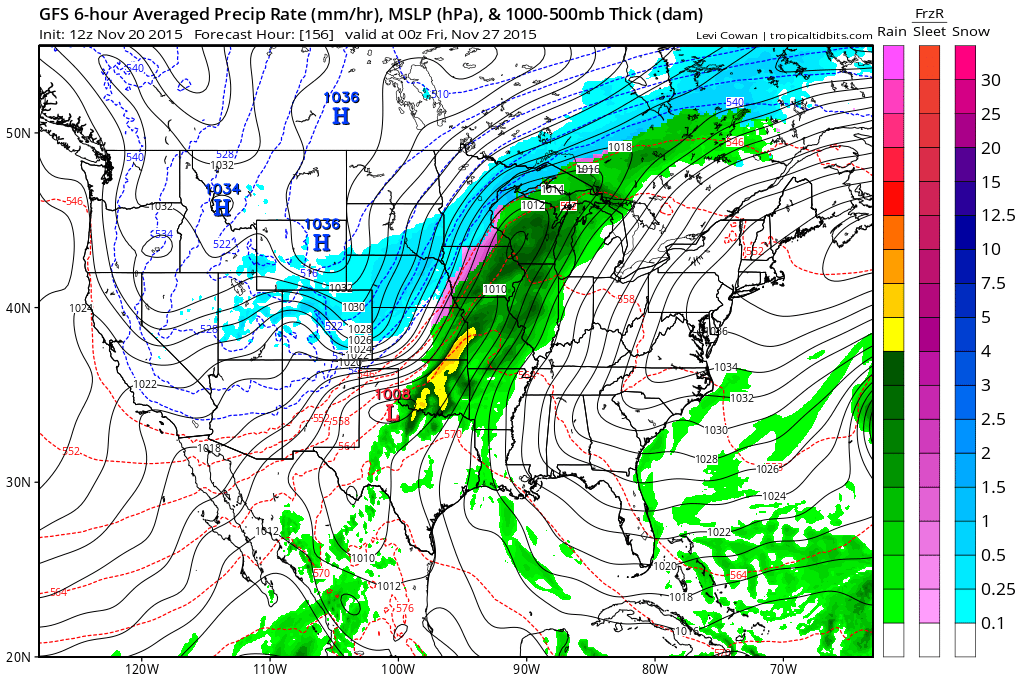
Then by Thursday evening the GFS brings rain into most of our area. Have to monitor to see if thunder will also be included in the forecast.
By Friday morning (black Friday) we can see the rain continues. Pockets of moderate rain.
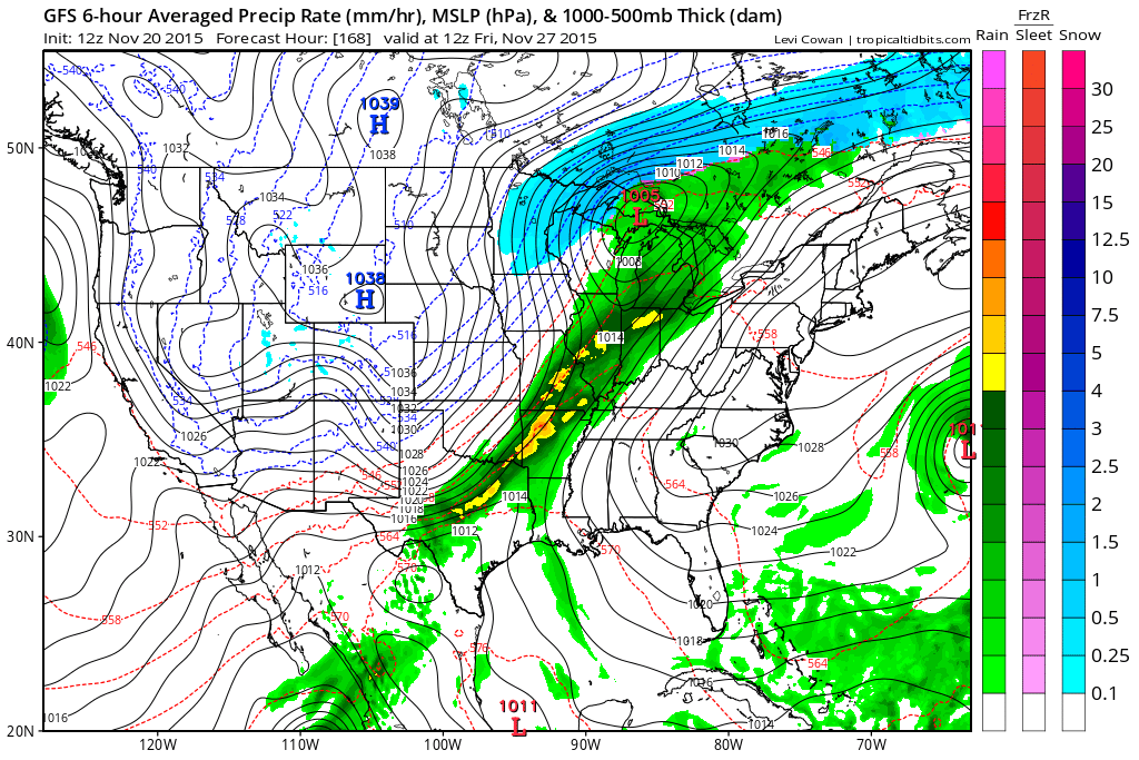
The front appears to stall out over our area on Friday night and Saturday. This occurs as additional waves/ripples of low pressure move along the boundary.
Thus, rain continues to fall over our area. I will keep an eye on the colder air as it pushes in on the backside of the system.
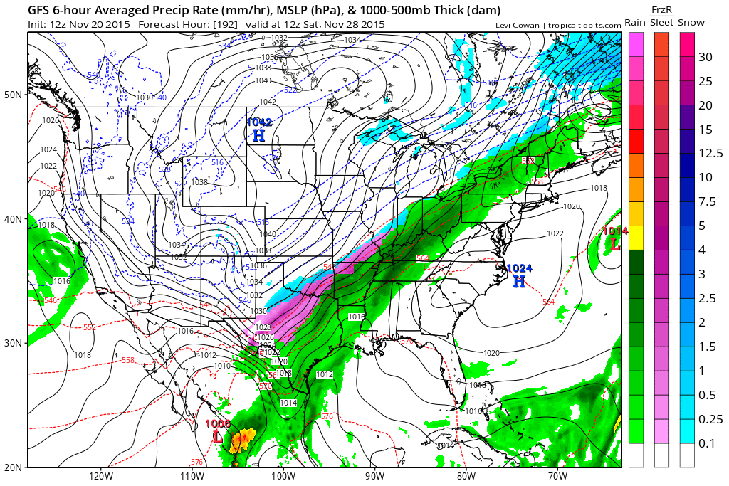
By Sunday morning the rain finally pushes off to our east. But, slowly. Let’s keep an eye on all of this. The timing is a bit suspect (the duration of the rain event).

No major shifts in the forecast.

No major concerns.

No

The wild card will be temperatures on Saturday night. How low will they go. Expecting 20s for most of the region. Brrr.

Freeze likely Sunday morning and Monday morning. Temperatures into the 20s.

No snow anticipated. Can’t completely rule out flurries on Saturday or Sunday. Nothing major.

No frozen precipitation through Wednesday. Again, other than the small chance for a stray flurry.

How much precipitation should we expect over the next few days?
No significant rain in the forecast through Sunday.
Light rain will develop ahead of a cold front on Friday night and Saturday morning. Less than 0.10″ over most of the area. Some locations won’t even pick that up.
Northern counties could pick up 0.10″-0.20″.
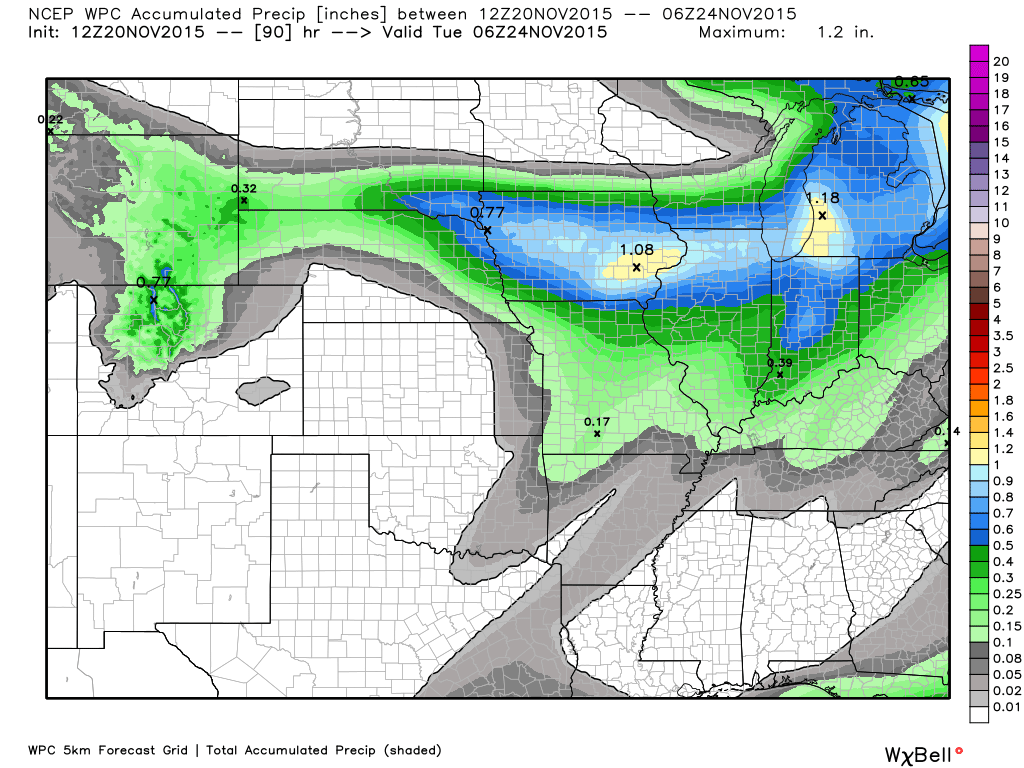
Here is the official rainfall forecast map. Check out northern Illinois. That is snow! Quite a bit of snow, at that. Perhaps 4-8″ in some locations. Isolated higher amounts.

Can we expect severe thunderstorms over the next 24 to 48 hours? Remember that a severe thunderstorm is defined as a thunderstorm that produces 58 mph winds or higher, quarter size hail or larger, and/or a tornado.
The thunderstorm threat level will be ZERO for Saturday through next Tuesday.
.
Saturday: Severe weather is not anticipated.
Sunday: Severe weather is not anticipated.
Monday: Severe weather is not anticipated.
Tuesday: Severe weather is not anticipated.
Wednesday: Severe weather is not anticipated.
Thursday: Severe weather is not anticipated.
Friday: Severe weather is not anticipated.


We have regional radars and local city radars – if a radar does not seem to be updating then try another one. Occasional browsers need their cache cleared. You may also try restarting your browser. That usually fixes the problem. Occasionally we do have a radar go down. That is why I have duplicates. Thus, if one fails then try another one.
If you have any problems then please send me an email beaudodson@usawx.com
WEATHER RADAR PAGE – Click here —
We also have a new national interactive radar – you can view that radar by clicking here.
Local interactive city radars include St Louis, Mt Vernon, Evansville, Poplar Bluff, Cape Girardeau, Marion, Paducah, Hopkinsville, Memphis, Nashville, Dyersburg, and all of eastern Kentucky – these are interactive radars. Local city radars – click here
NOTE: Occasionally you will see ground clutter on the radar (these are false echoes). Normally they show up close to the radar sites – including Paducah.

Regional Radar – Click on radar to take you our full radar page.


Live Lightning Data – zoom and pan: Click here
Live Lightning Data with sound (click the sound button on the left side of the page): Click here

I also set up a storm tracking page with additional links (use during active weather for quick reference)
Storm Tracking Tool Page
![]()
Current WARNINGS (a warning means take action now). Click on your county to drill down to the latest warning information. Keep in mind that there can be a 2-3 minute delay in the updated warning information.
I strongly encourage you to use a NOAA Weather Radio or warning cell phone app for the most up to date warning information. Nothing is faster than a NOAA weather radio.


Color shaded counties are under some type of watch, warning, advisory, or special weather statement. Click your county to view the latest information.

Missouri Warnings

Illinois Warnings

Kentucky Warnings

Here is the official 6-10 day and 8-14 day temperature and precipitation outlook. Check the date stamp at the top of each image (so you understand the time frame).
The forecast maps below are issued by the Weather Prediction Center (NOAA).


The latest 8-14 day temperature and precipitation outlook. Note the dates are at the top of the image. These maps DO NOT tell you how high or low temperatures or precipitation will be. They simply give you the probability as to whether temperatures or precipitation will be above or below normal.


Here are the current river stage forecasts. You can click your state and then the dot for your location. It will bring up the full forecast and hydrograph.
Click Here For River Stage Forecasts…
Here are some current forecast hydrographs. These will be updated each day with new information.


Smithland Lock and Dam

Paducah, Kentucky Forecast Stage

Cairo, Illinois

Cape Girardeau, Missouri

Who do you trust for your weather information and who holds them accountable?
I have studied weather in our region since the late 1970’s. I have 37 years of experience in observing our regions weather patterns. My degree is in Broadcast Meteorology from Mississippi State University and an Associate of Science (AS). I am currently working on my Bachelor’s Degree in Geoscience.
My resume includes:
Member of the American Meteorological Society.
NOAA Weather-Ready Nation Ambassador.
Meteorologist for McCracken County Emergency Management.
I own and operate the Southern Illinois Weather Observatory.
Recipient of the Mark Trail Award, WPSD Six Who Make A Difference Award, Kentucky Colonel, and the Caesar J. Fiamma” Award from the American Red Cross.
In 2009 I was presented with the Kentucky Office of Highway Safety Award.
Recognized by the Kentucky House of Representatives for my service to the State of Kentucky leading up to several winter storms and severe weather outbreaks.
I am also President of the Shadow Angel Foundation which serves portions of western Kentucky and southern Illinois.
There is a lot of noise on the internet. A lot of weather maps are posted without explanation. Over time you should learn who to trust for your weather information.
My forecast philosophy is simple and straight forward.
- Communicate in simple terms
- To be as accurate as possible within a reasonable time frame before an event
- Interact with you on Twitter, Facebook, and the blog
- Minimize the “hype” that you might see on television or through other weather sources
- Push you towards utilizing wall-to-wall LOCAL TV coverage during severe weather events
I am a recipient of the Mark Trail Award, WPSD Six Who Make A Difference Award, Kentucky Colonel, and the Caesar J. Fiamma” Award from the American Red Cross. In 2009 I was presented with the Kentucky Office of Highway Safety Award. I was recognized by the Kentucky House of Representatives for my service to the State of Kentucky leading up to several winter storms and severe weather outbreaks.
If you click on the image below you can read the Kentucky House of Representatives Resolution.

Many of my graphics are from www.weatherbell.com – a great resource for weather data, model data, and more


You can sign up for my AWARE email by clicking here I typically send out AWARE emails before severe weather, winter storms, or other active weather situations. I do not email watches or warnings. The emails are a basic “heads up” concerning incoming weather conditions.