We have some great sponsors for the Weather Talk Blog. Please let our sponsors know that you appreciate their support for the Weather Talk Blog.
Milner and Orr Funeral Home and Cremation Services located in Paducah, Kentucky and three other western Kentucky towns – at Milner and Orr they believe in families helping families. You can find Milner and Orr on Facebook, as well.
![]()
.

Wortham Dental Care located in Paducah, Kentucky. The gentle dentist. Mercury free dentistry. They also do safe Mercury removal. You can find Wortham Dental Care on Facebook, as well
.

For all of your families eye care needs. Visit their web-site here. Or, you can also visit their Facebook page.
.

Endrizzi’s Storm Shelters – For more information click here. Endrizzi Contracting and Landscaping can be found on Facebook, as well – click here
.

Best at Enabling Body Shop Profitability since 1996. Located In Paducah Kentucky and Evansville Indiana; serving all customers in between. They provide Customer Service, along with all the tools necessary for body shops to remain educated and competitive. Click the logo above for their main web-site. You can find McClintock Preferred Finishes on Facebook, as well
.

Duck/goose decoys? Game calls? Optics? We have you covered! Click the logo above or visit Final Flight on Facebook, as well.

This forecast update covers far southern Illinois, far southeast Missouri, and far western Kentucky. See the coverage map on the right side of the blog.
Remember that weather evolves. Check back frequently for updates, especially during active weather.
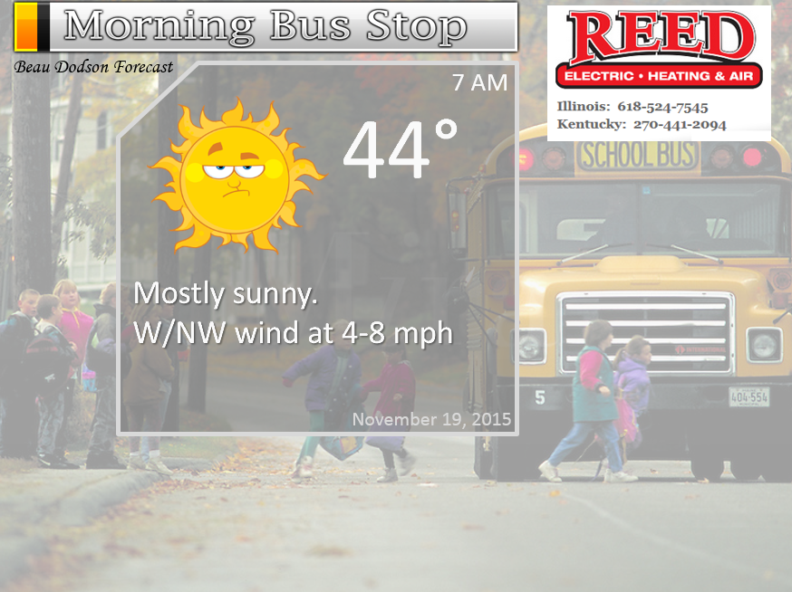
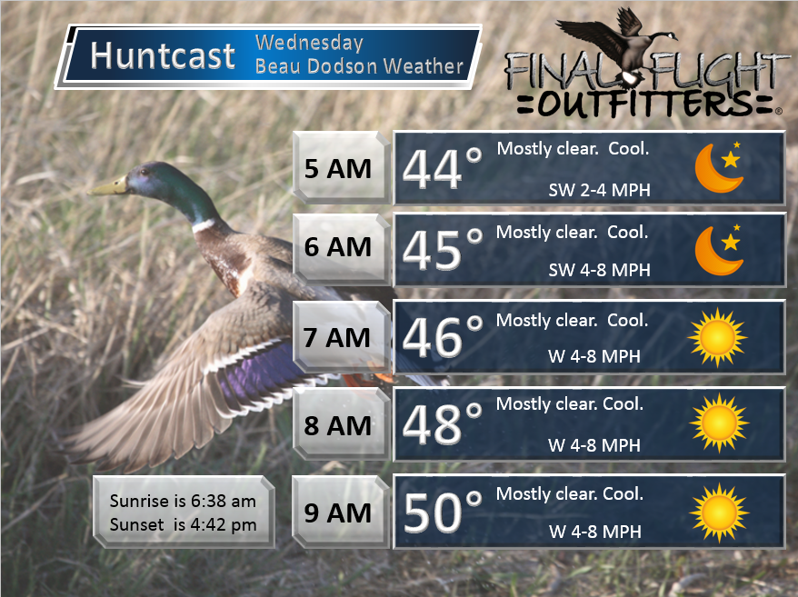
Wednesday night – A few clouds. Otherwise, clearing sky conditions and cool.
Temperatures: Lows in the 38 to 44 degree range
Winds: West/southwest winds at 6-12 mph with gusts to 15 mph
What is the chance for precipitation? 0%
Coverage of precipitation? None
My confidence in this part of the forecast verifying is High
Should I cancel my outdoor plans? No
Is severe weather expected? No
What impact is expected? None
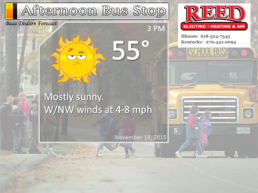
Thursday – Partly sunny.
Temperatures: Highs in the middle to upper 50s
Winds: West becoming north/northwest winds at 4-8 mph. Gusts to 12 mph.
What is the chance for precipitation? 0%
Coverage of precipitation? None
My confidence in this part of the forecast verifying is High
Should I cancel my outdoor plans? No
Is severe weather expected? No
What impact is expected? None
Thursday night – Mostly clear. Chilly. Frost possible. Perhaps a freeze.
Temperatures: Lows in the lower to middle 30s.
Winds: Northeast winds at 5 mph
What is the chance for precipitation? 0%
Coverage of precipitation? None
My confidence in this part of the forecast verifying is High
Should I cancel my outdoor plans? No
Is severe weather expected? No
What impact is expected? Frost/freeze
Friday – Partly to mostly sunny.
Temperatures: Highs in the lower to middle 50s
Winds: Northeast/east winds at 4-8 mph.
What is the chance for precipitation? 0%
Coverage of precipitation? None
My confidence in this part of the forecast verifying is High
Should I cancel my outdoor plans? No
Is severe weather expected? No
What impact is expected? None
Friday night – Becoming cloudy. Cold.
Temperatures: Lows in the middle to upper 30s.
Winds: Northeast winds at 5 mph
What is the chance for precipitation? 0%
Coverage of precipitation? None
My confidence in this part of the forecast verifying is High
Should I cancel my outdoor plans? No
Is severe weather expected? No
What impact is expected? Frost possible
Saturday – Partly cloudy. Perhaps more clouds over our northern counties vs southern. Small chance for sprinkles. Chilly. Becoming windy. Falling temperatures in the afternoon.
Temperatures: Highs in the upper 40s and lower 50s. Temperatures may actually fall during the day.
Winds: North/northwest winds at 10-20 mph. Gusty winds at times.
What is the chance for precipitation? 0%
Coverage of precipitation? None
My confidence in this part of the forecast verifying is High
Should I cancel my outdoor plans? No
Is severe weather expected? No
What impact is expected? None
Saturday night – Mostly clear. Cold. A freeze likely. Temperatures below 32 degrees for a prolonged period of time.
Temperatures: Lows in the 22 to 28 degree range. Pockets of colder.
Winds: North winds at 0-5 mph
What is the chance for precipitation? 0%
Coverage of precipitation? None
My confidence in this part of the forecast verifying is High
Should I cancel my outdoor plans? No
Is severe weather expected? No
What impact is expected? Frost/freeze likely
Sunday – Partly sunny. Chilly.
Temperatures: Highs in the upper 30s and lower 40s
Winds: West winds at 4-8 mph.
What is the chance for precipitation? 0%
Coverage of precipitation? None
My confidence in this part of the forecast verifying is High
Should I cancel my outdoor plans? No
Is severe weather expected? No
What impact is expected? None
Sunday night – Mostly clear. Cold.
Temperatures: Lows in the middle 20s
Winds: North winds at 0-5 mph
What is the chance for precipitation? 0%
Coverage of precipitation? None
My confidence in this part of the forecast verifying is High
Should I cancel my outdoor plans? No
Is severe weather expected? No
What impact is expected? Frost/freeze likely
Monday – Partly sunny.
Temperatures: Highs in the upper 40s
Winds: West winds at 4-8 mph.
What is the chance for precipitation? 0%
Coverage of precipitation? None
My confidence in this part of the forecast verifying is High
Should I cancel my outdoor plans? No
Is severe weather expected? No
What impact is expected? None
Click their ad below to visit their web-site or click here reedelec.com


![]()


Don’t forget to check out the Southern Illinois Weather Observatory web-site for weather maps, tower cams, scanner feeds, radars, and much more! Click here

An explanation of what is happening in the atmosphere over the coming days…
Highlights
1. Calm and cool weather into the weekend
2. Quite chilly by the weekend, as well.
3. Widespread freeze likely Saturday night/Sunday night with temperatures into the 20s
4. Watching a system around Thanksgiving. Rain perhaps?
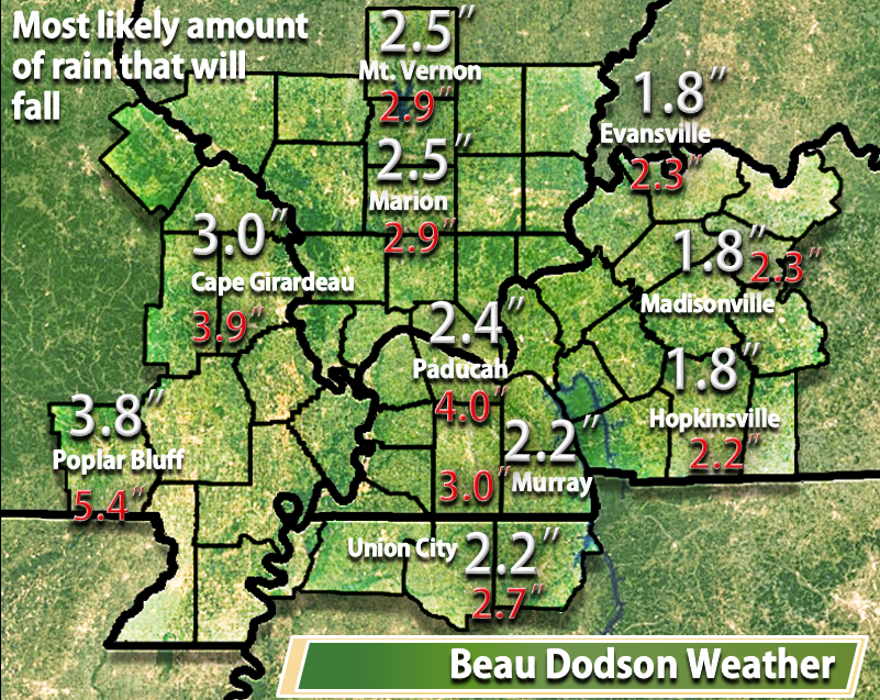
Well, our rain system has pushed off to the east. We sure did need the rain. Most areas picked up between 1″ and 4″. There were pockets of heavier amounts here and there. Southeast Missouri had a few flash flood warnings. They received the most rain. I did not see any reports of significant flooding problems.
Let’s review my forecast.
Forecast for widespread 1-3″ of rain in the region with pockets of 4-5″. Heaviest totals were forecast to be over southeast Missouri and southwest Illinois. Least amount of rain would fall over our eastern counties.
The forecast was for no significant flooding or flash flooding problems.
The forecast was for no severe weather in our local counties. Severe weather being defined as 58 mph thunderstorm winds. A tornado. And/or 1″ hail or larger. That is the official NWS definition for severe weather.
And the winds were forecast to be in the 30-40 range with gusts above that. This was because of the strong jet stream aloft.
I put out an over/under rainfall forecast. I like to do that for big rain events. Mainly because rain totals will vary greatly over our area during an event like this. And, that indeed did happen.
Here was what I expected to happen. Or, the most likely scenario. The actual amounts are in red. These are official reporting station reports. Of course, rainfall can vary from place to place within a county.
And here was my high end map. Actual totals are in red.
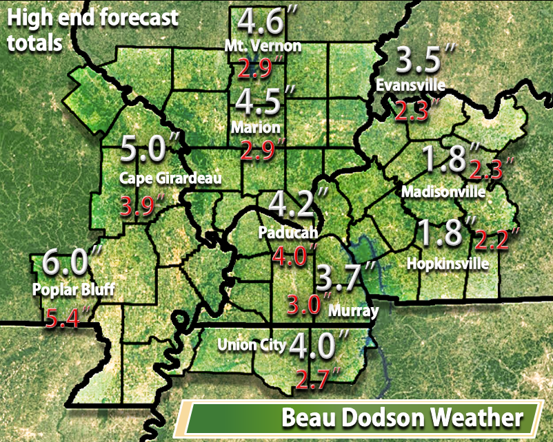
All in all this system behaved as expected.
No significant flooding occurred. There was no real risk for flash flooding except perhaps a few pockets in southeast Missouri. Which, was mentioned in the forecast.
No severe weather occurred. No severe thunderstorms or tornadoes.
The wind forecast for Tuesday night verified with numerous reports of 30-40 mph winds with higher gusts.
It was a nice rain event for our region. We sure did need this event. I am happy with the overall outcome.
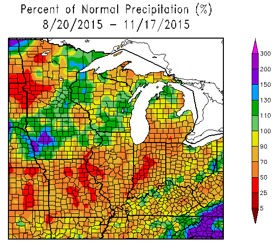
This is the departure from normal precipitation over the past 90 days. You can see we needed this rain.
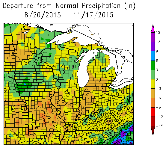
Parts of our region have only had 40-60% of normal rainfall over the past 90 days. Dry.
This chart below shows you the % of normal precipitation. Check out parts of the Missouri and Ohio Valleys. 30%-50% of normal rainfall. A dry fall for our region. Until recently when several rain events have helped our rainfall deficits.
The good news is that the weather will be calm into the weekend. Now that we picked up quite a bit of rain I suppose we can use a few days of dry weather.
A cold weekend is anticipated. Expect overnight lows into the 20s on Sunday morning. Highs on Sunday may not rise above 40 degrees over some of our counties. Cold for this time of the year.
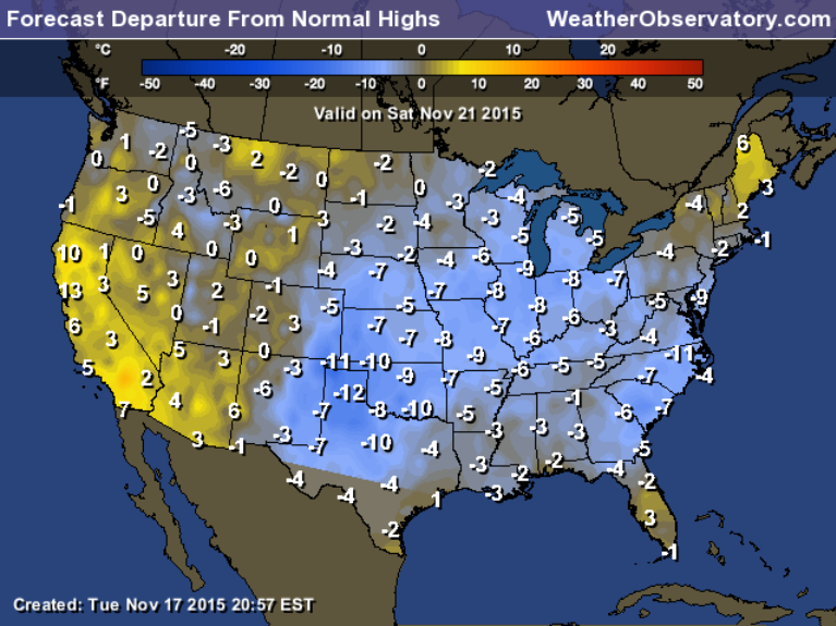
Let’s look at temperature anomalies. How much above or below normal will temperatures be on Saturday and Sunday?
This first map is for Saturday. Well below normal temperatures.
Normal highs for this time of the year are around 56 degrees and normal lows are around 36 degrees.
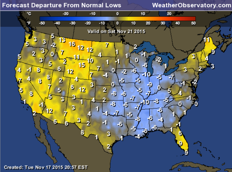
Here is the Saturday night map/Sunday morning temperature anomaly maps. How many degrees below normal will it be? Several!
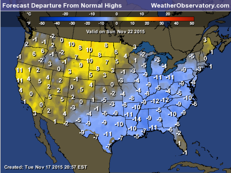
And here is the Sunday temperature departure map
Look at December. At one time I was thinking December might deliver colder than normal weather. But, almost all of the data indicates warmer than normal. So, that is how December might shape up. If it is warmer than normal then precipitation might also be above normal.
This map is the seasonal forecast map for December. Red would indicate above normal temperatures. That is a LOT of red!
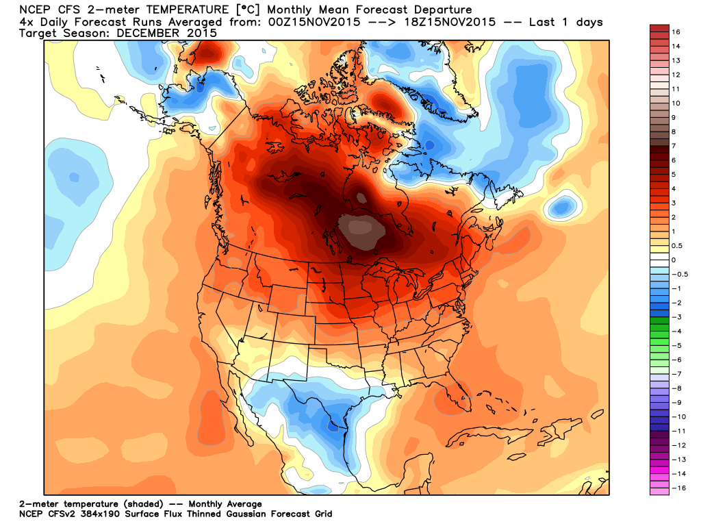
I do believe January into March will deliver colder than normal conditions. A back loaded winter has been my thinking.
We shall see!

Lowered weekend temperatures even more. Cold weekend.

No major concerns.

No

The wild card will be temperatures on Saturday night. How low will they go. Expecting 20s for most of the region. Brrr.

Frost possible Friday and Saturday morning. Freeze likely Saturday night/Sunday morning. Temperatures down into the 20s.

How much precipitation should we expect over the next few days?
No rain in the forecast through Sunday.

Can we expect severe thunderstorms over the next 24 to 48 hours? Remember that a severe thunderstorm is defined as a thunderstorm that produces 58 mph winds or higher, quarter size hail or larger, and/or a tornado.
The thunderstorm threat level will be ZERO for Wednesday through Sunday.
.
Wednesday: Severe weather is not anticipated.
Thursday: Severe weather is not anticipated.
Friday: Severe weather is not anticipated.
Saturday: Severe weather is not anticipated.
Sunday: Severe weather is not anticipated.
Monday: Severe weather is not anticipated.


We have regional radars and local city radars – if a radar does not seem to be updating then try another one. Occasional browsers need their cache cleared. You may also try restarting your browser. That usually fixes the problem. Occasionally we do have a radar go down. That is why I have duplicates. Thus, if one fails then try another one.
If you have any problems then please send me an email beaudodson@usawx.com
WEATHER RADAR PAGE – Click here —
We also have a new national interactive radar – you can view that radar by clicking here.
Local interactive city radars include St Louis, Mt Vernon, Evansville, Poplar Bluff, Cape Girardeau, Marion, Paducah, Hopkinsville, Memphis, Nashville, Dyersburg, and all of eastern Kentucky – these are interactive radars. Local city radars – click here
NOTE: Occasionally you will see ground clutter on the radar (these are false echoes). Normally they show up close to the radar sites – including Paducah.

Regional Radar – Click on radar to take you our full radar page.


Live Lightning Data – zoom and pan: Click here
Live Lightning Data with sound (click the sound button on the left side of the page): Click here

I also set up a storm tracking page with additional links (use during active weather for quick reference)
Storm Tracking Tool Page
![]()
Current WARNINGS (a warning means take action now). Click on your county to drill down to the latest warning information. Keep in mind that there can be a 2-3 minute delay in the updated warning information.
I strongly encourage you to use a NOAA Weather Radio or warning cell phone app for the most up to date warning information. Nothing is faster than a NOAA weather radio.


Color shaded counties are under some type of watch, warning, advisory, or special weather statement. Click your county to view the latest information.

Missouri Warnings

Illinois Warnings

Kentucky Warnings

Here is the official 6-10 day and 8-14 day temperature and precipitation outlook. Check the date stamp at the top of each image (so you understand the time frame).
The forecast maps below are issued by the Weather Prediction Center (NOAA).


The latest 8-14 day temperature and precipitation outlook. Note the dates are at the top of the image. These maps DO NOT tell you how high or low temperatures or precipitation will be. They simply give you the probability as to whether temperatures or precipitation will be above or below normal.


Here are the current river stage forecasts. You can click your state and then the dot for your location. It will bring up the full forecast and hydrograph.
Click Here For River Stage Forecasts…
Here are some current forecast hydrographs. These will be updated each day with new information.


Smithland Lock and Dam

Paducah, Kentucky Forecast Stage

Cairo, Illinois

Cape Girardeau, Missouri

Who do you trust for your weather information and who holds them accountable?
I have studied weather in our region since the late 1970’s. I have 37 years of experience in observing our regions weather patterns. My degree is in Broadcast Meteorology from Mississippi State University and an Associate of Science (AS). I am currently working on my Bachelor’s Degree in Geoscience.
My resume includes:
Member of the American Meteorological Society.
NOAA Weather-Ready Nation Ambassador.
Meteorologist for McCracken County Emergency Management.
I own and operate the Southern Illinois Weather Observatory.
Recipient of the Mark Trail Award, WPSD Six Who Make A Difference Award, Kentucky Colonel, and the Caesar J. Fiamma” Award from the American Red Cross.
In 2009 I was presented with the Kentucky Office of Highway Safety Award.
Recognized by the Kentucky House of Representatives for my service to the State of Kentucky leading up to several winter storms and severe weather outbreaks.
I am also President of the Shadow Angel Foundation which serves portions of western Kentucky and southern Illinois.
There is a lot of noise on the internet. A lot of weather maps are posted without explanation. Over time you should learn who to trust for your weather information.
My forecast philosophy is simple and straight forward.
- Communicate in simple terms
- To be as accurate as possible within a reasonable time frame before an event
- Interact with you on Twitter, Facebook, and the blog
- Minimize the “hype” that you might see on television or through other weather sources
- Push you towards utilizing wall-to-wall LOCAL TV coverage during severe weather events
I am a recipient of the Mark Trail Award, WPSD Six Who Make A Difference Award, Kentucky Colonel, and the Caesar J. Fiamma” Award from the American Red Cross. In 2009 I was presented with the Kentucky Office of Highway Safety Award. I was recognized by the Kentucky House of Representatives for my service to the State of Kentucky leading up to several winter storms and severe weather outbreaks.
If you click on the image below you can read the Kentucky House of Representatives Resolution.

Many of my graphics are from www.weatherbell.com – a great resource for weather data, model data, and more


You can sign up for my AWARE email by clicking here I typically send out AWARE emails before severe weather, winter storms, or other active weather situations. I do not email watches or warnings. The emails are a basic “heads up” concerning incoming weather conditions.