
November 17, 2014: This forecast update covers far southern Illinois, far southeast Missouri, and far western Kentucky. See the coverage map on the right side of the blog.
Monday – Cloudy this morning with some breaks in the clouds later today. Snow coming to an end. Flurries possible into the afternoon hours. Temperatures holding steady in the 20’s and 30’s. Becoming windy at times. Northwest winds at 10-20 mph. Wind chills of 0-15 degrees.
Morning School Bus Stop Weather – Cloudy with some flurries. Cold. Temperatures in the 20’s. Wind chills in the teens. Northwest winds at 10-15 mph.
Afternoon School Bus Stop Weather – Cloudy. A few flurries. Cold. Windy. Temperatures only in the 20’s. Wind chills in the 0-15 degree range. Northwest winds at 10-20 mph.
Monday night – Some clouds and flurries. Near record cold temperatures. Lows in the 10 degrees above to 15 degrees above range. Northwest winds at 10-15 mph. Wind chills in the single digits.
Tuesday – A mix of sun and clouds. Cold. Temperatures will not get out of the 20’s. West/northwest winds at 10-15 mph. Wind chills in the teens.
Tuesday night – A few clouds. Cold. Well below normal temperatures. Lows in the upper teens and lower 20’s. West/northwest winds at 5-10 mph.
Wednesday – Partly cloudy and cold. High temperatures only in the upper 30’s. West winds at 10 mph.
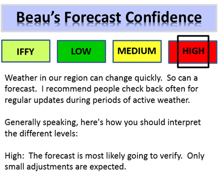
Confidence in the above forecast:

An explanation of what is happening in the atmosphere over the coming days.
Wow, our first winter storm is winding down across the area. Snow and sleet fell overnight across much of the area. The snow is ending from west to east this morning. Some of you picked up what was expected and some a bit less. Typical winter system for our region. there are always a few spots with more and some with less.
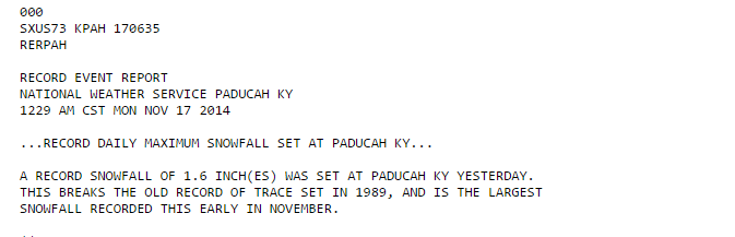
Paducah set a snowfall record…
The toughest area was just about as expected – our eastern and southeast counties where rain lingered the longest.
Lot of schools are closed this morning. I hope everyone is able to enjoy their day off. For those who must get out and work – travel safely.
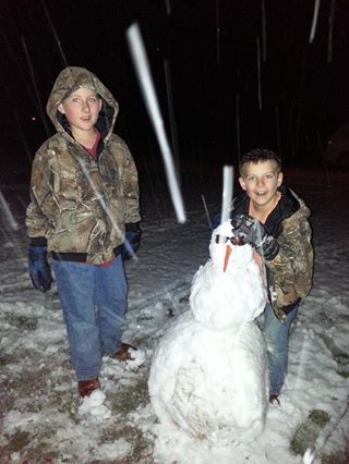
Lauren Gray (Simpson, Illinois) posted this image on Facebook. The first snowman of the new winter season?

We have some school closings, some slick roads, and a lot of cold air. Temperatures are not expected to rise today. Some areas will remain in the 20’s. Winds will also become gusty out of the west/northwest at 10-20 mph.
Wind chills are going to be an issue right on into Tuesday. Expect wind chill temperatures in the 0 to 15 degree range. Bundle those kids up. Those outdoors will want to take precautions to prevent frost-bite.
Don’t forget about our outdoor friends.
Clouds will linger into tonight with occasional flurries. By Tuesday morning we will find ourselves in the ice box. Low temperatures will range from 10-15 degrees across the area. Once again, this is more like January than November. We may experience record lows tonight.
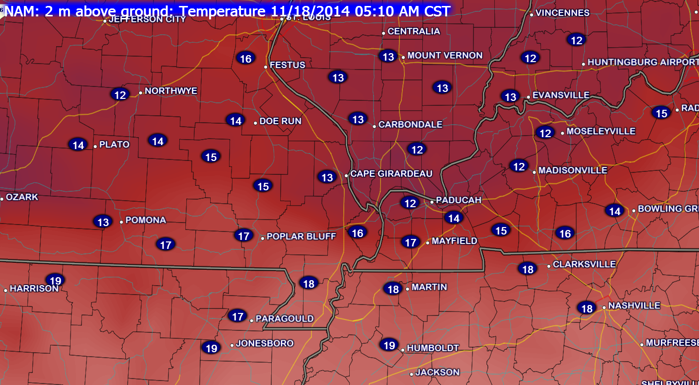
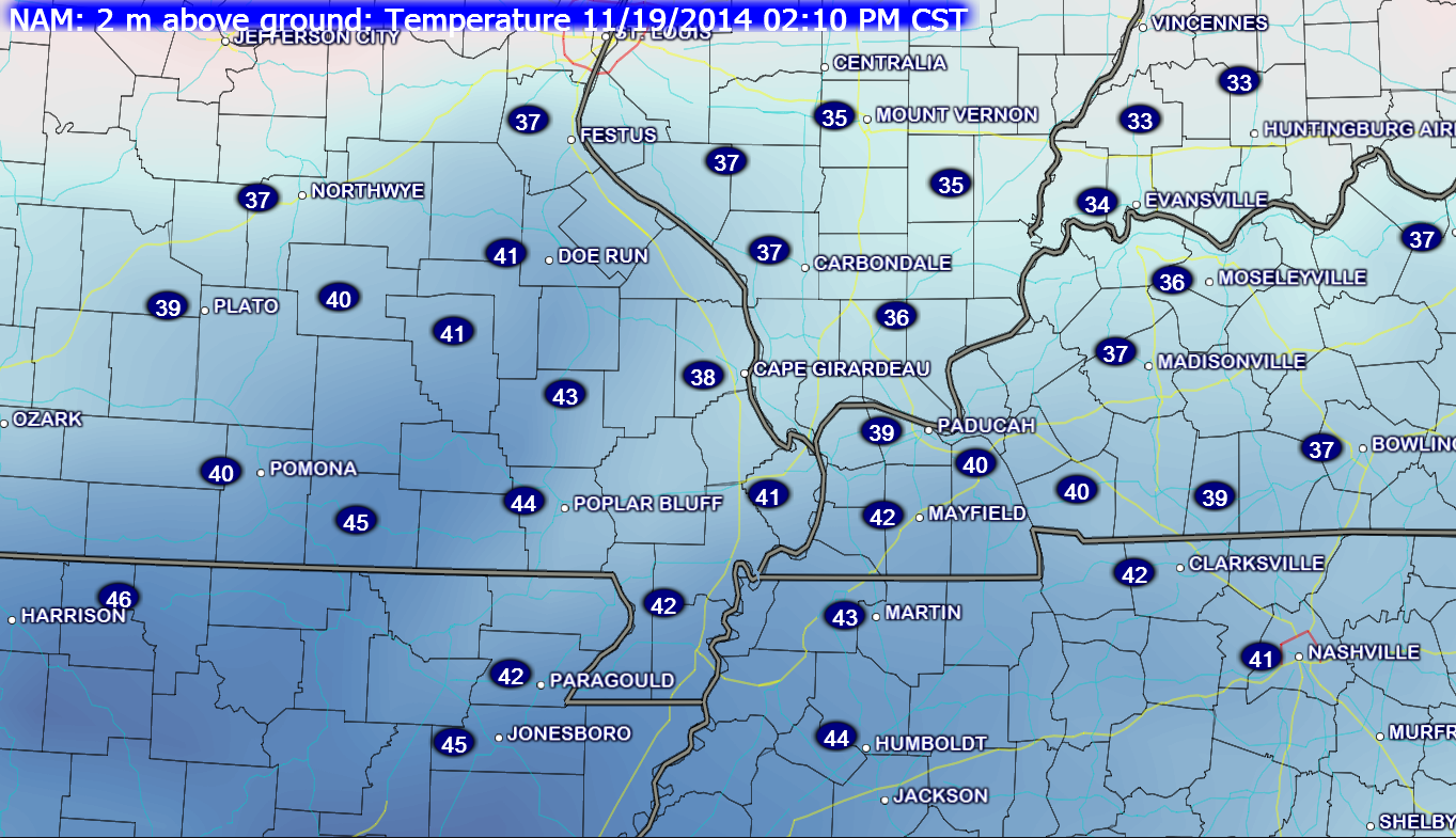
Here is the temperature forecast for tomorrow morning – areas with snow will be the coldest.
Perhaps by Wednesday we will see temperatures start to creep up just a tad. Still, well below normal.
Tuesday and Wednesday should be dry, but cold. Highs on Tuesday will likely remain in the 20’s. Incredible weather for November.
Let’s take a look at the current temperature map across the region.

Current National Temperature Map

IR Satellite Image – during cold weather there could be a lot of white on this map. That is not necessarily clouds. Cold temperatures can also show up on this satellite image.
Typically the brighter colors represent clouds.

Water Vapor Satellite Map – this satellite image gives you a good idea of when moisture is streaming into our region.

Expected High Temperatures For Today

Forecast Low Temperatures For Tonight


No changes to the forecast. I put tonight’s lows in the 10-15 degree range. Tough call for areas with snow cover.

Bitterly cold air through Tuesday. Wind chills will be in the single digits from time to time.
Untreated roads will have slick spots. Areas that picked up the heaviest snow will experience black ice tonight. Untreated roads and back-roads will have slick spots.
Use care.
Wind chill forecast for today

Wind chills for tomorrow


Give yourself extra time if you have to travel today (in areas that received snow and sleet overnight).
Don’t forget about our outdoor pets. Water bowls will freeze. Wind chills will be bitterly cold. Actual air temperatures tonight will dip into the 8-15 degree range.

The Wild Card gives you an idea of what might change that would cause the forecast to bust. A busted forecast means a forecast that does not verify.
Wild card in this forecast will be the low temperature forecast for later tonight and Tuesday morning. Areas with a decent snow pack could dip into the single digits. Certainly some lower teens are possible. Near record lows.

Precipitation forecast for the next 24-48 hours…
No additional measurable precipitation is expected once our morning snow pushes east of the area.

Bitterly cold air with flurries into tonight. Bitterly cold air into Wednesday.

A brief look ahead. A lot of time was spend over the last 3 or 4 days covering the winter storm. I will try to dig a bit more into the extended forecast in tomorrow mornings update.
It appears that temperatures will start to moderate a bit by Wednesday and Thursday. We might even experience some 40’s! Wow, a heat wave. 🙂 Who would believe that in the middle of November we would consider temperatures in the 40’s as mild? Normal highs for this time of the year are around 60 degrees.
There are some indications that we may have to put precipitation chances back in the forecast by Thursday, Friday, and Saturday. Confidence in the extended forecast is low. Precipitation would probably start out as a wintry mix and change to rain.
WARMER air by Sat night into Sunday. I might have to put thunderstorms in the forecast for Saturday night or Sunday. A potent storm may develop and move north into our region. Too soon for specifics. Some of the data does indicate temperatures would briefly rise into the upper 50’s or lower 60’s by Sunday. Again, long way off for details.
I am watching a storm system for Thanksgiving week, as well. Too far out for details. I will continue to watch it as we move forward.
Another weather maker towards Thursday and Friday of this week?
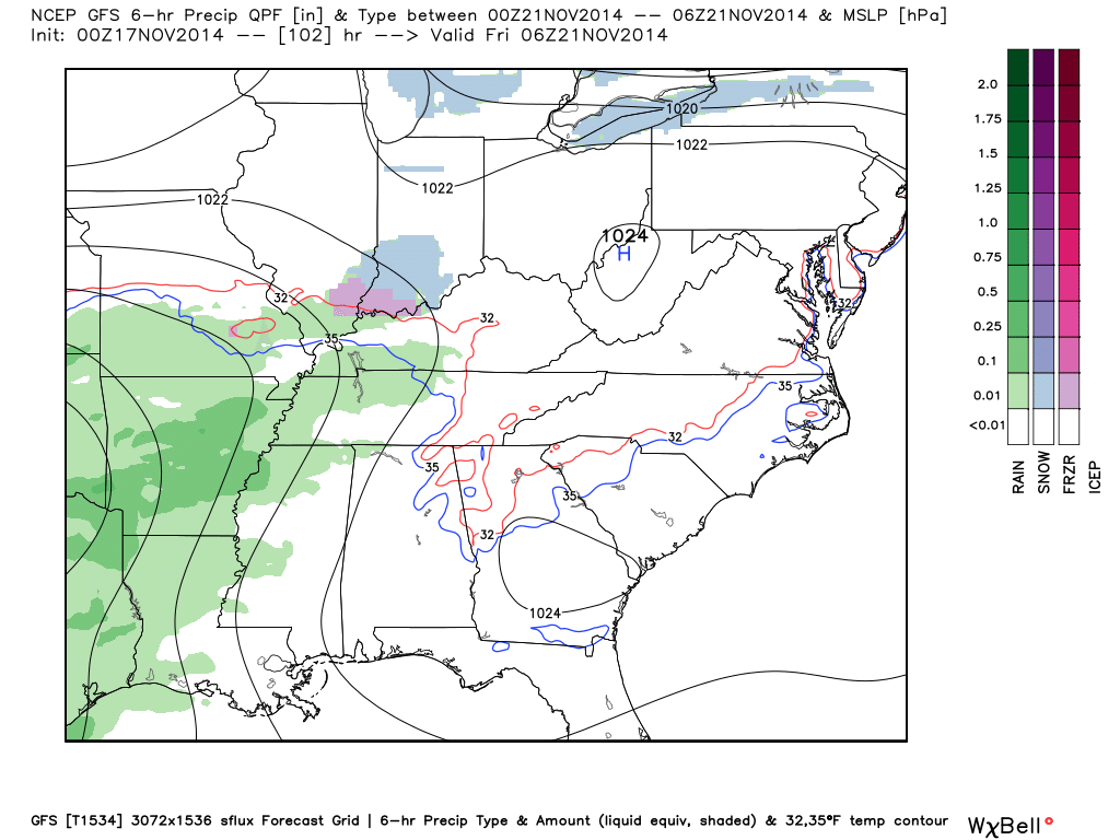
The GFS model is picking up on the late week precipitation potential. I have not had time to dig too deep into whether this will or won’t happen. But, the general idea is on the map.
Let’s take a look at the high resolution GFS model for system one
This would be on Thursday night and Friday. You can see the colors represent precipitation. Whether it will be cold enough for a wintry mix is still in question.
Thursday night at 1 AM – you can see the GFS is trying to push rain, sleet, and snow back into our region from the south. Again, low confidence as to how this unfold. It is still four days out. Plenty of time to monitor.
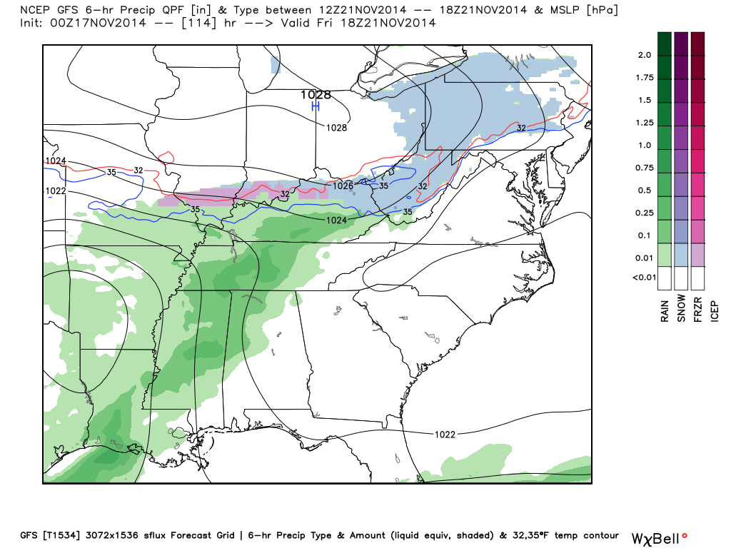
Here is the Friday afternoon GFS map – you can see precipitation still in our region. That thin blue line is the 32 degree line. The green colors represent rain. The purple and blue represent snow and a wintry mix.
Some extended temperature and precipitation outlooks…


The latest 8-14 day temperature and precipitation outlook. Note the dates are at the top of the image. These maps DO NOT tell you how high or low temperatures or precipitation will be. They simply give you the probability as to whether temperatures or precipitation will be above or below normal.


Can we expect severe thunderstorms over the next 24 to 48 hours? Remember that a severe thunderstorm is defined as a thunderstorm that produces 58 mph winds or higher, quarter size hail or larger, and/or a tornado.
Severe weather is not going to be a concern through Thursday.
Thunderstorm threat level is zero.


Please visit your local National Weather Service Office by clicking here. The National Weather Service Office, for our region, is located in Paducah, Kentucky.
![]()
We have regional radars and local city radars – if a radar does not seem to be updating then try another one. Occasional browsers need their cache cleared. You may also try restarting your browser. That usually fixes the problem. Occasionally we do have a radar go down. That is why I have duplicates. Thus, if one fails then try another one.
If you have any problems then please send me an email beaudodson@usawx.com
WEATHER RADAR PAGE – Click here —
We also have a new national interactive radar – you can view that radar by clicking here.
Local interactive city radars include St Louis, Mt Vernon, Evansville, Poplar Bluff, Cape Girardeau, Marion, Paducah, Hopkinsville, Memphis, Nashville, Dyersburg, and all of eastern Kentucky – these are interactive radars. Local city radars – click here
NOTE: Occasionally you will see ground clutter on the radar (these are false echoes). Normally they show up close to the radar sites – including Paducah.

Regional Radar – Click on radar to take you our full radar page.


Regional Radar

Current WARNINGS (a warning means take action now). Click on your county to drill down to the latest warning information. Keep in mind that there can be a 2-3 minute delay in the updated warning information.
I strongly encourage you to use a NOAA Weather Radio or warning cell phone app for the most up to date warning information. Nothing is faster than a NOAA weather radio.


Missouri Warnings

Illinois Warnings

Kentucky Warnings
I have added a lot of new maps to the Southern Illinois Weather Observatory web-site. Check them out by clicking here.
Current tower cam view from the Weather Observatory- Click here for all cameras.

Southern Illinois Weather Observatory

The Weather Observatory

Southern Illinois Weather Observatory
WPSD TV 6 has a number of tower cameras. Click here for their tower camera page
& Kentucky Road Conditions & Kentucky Highway and Interstate Cameras

Downtown Paducah, Kentucky
Benton, Kentucky Tower Camera – Click here for full view

Benton, Kentucky
WSIL TV 3 has a number of tower cameras. Click here for their tower camera page
& Illinois Road Conditions

Marion, Illinois

You can sign up for my AWARE email by clicking here I typically send out AWARE emails before severe weather, winter storms, or other active weather situations. I do not email watches or warnings. The emails are a basic “heads up” concerning incoming weather conditions.