
November 16, 2014: This forecast update covers far southern Illinois, far southeast Missouri, and far western Kentucky. See the coverage map on the right side of the blog.
WINTER WEATHER ADVISORY AND WINTER STORM WARNING COVERS MUCH OF THE AREA FOR THIS EVENING INTO MONDAY MORNING…
Sunday – Mostly cloudy. Small chance for precipitation before 12 pm. A chance for a mixture of snow, sleet, and rain this afternoon. Precipitation will spread in from the west and south. High temperatures will be in the upper 30’s over far southern Illinois and western Kentucky. Temperatures will be a bit colder over southeast Missouri and southwest Illinois/southwest Indiana. South winds at 5-10 mph. Winds turning out of the west/northwest late on the day.
Sunday night – Snow, sleet, and rain. Wintry mix turning to all snow as the night wears on. Accumulation likely. Slick roads likely. Temperatures will fall into the 20’s by Monday morning. Northwest winds increasing from 5-10 mph to 10-15 mph. Wind chills dropping into the single digits and teens.
Monday – Mostly cloudy. Lingering snow will end from west to east. A chance for light snow showers and flurries into the afternoon hours. Windy at times. Cold. Northwest winds at 10-20 mph. Temperatures will hold in the 20’s and 30’s – temperatures will fall in the afternoon. Wind chill temperatures dropping into the single digits.
Monday night – Partly cloudy. A chance for light snow showers or flurries. Very cold for this time of the year. Low temperatures will be in the lower to middle teens. Northwest winds at 5-15 mph. Wind chills will be in the 0-10 degree range.
Tuesday – Partly sunny. A flurry possible. Bitterly cold during the morning hours. Cold during the day with WELL below normal temperatures. It will feel like January. High temperatures will not get out of the 20’s. West winds at 10-15 mph. Wind chills in the teens.

An explanation of what is happening in the atmosphere over the coming days.
Will keep it fairly brief this morning. The focus is on our much anticipated winter storm that will move into the region today and tonight.
Precipitation is already showing up on radar to our west and south. This precipitation will only increase throughout the day and into the afternoon.
Precipitation will begin as a wintry mix – there will also be some rain involved in areas that are above freezing. I have lowered high temperature forecast numbers for this afternoon – by a few degrees.
All the precipitation will eventually change to sleet and snow tonight. Sleet may keep snowfall accumulations down a bit in some areas. Sleet does not accumulate as fast as snow.
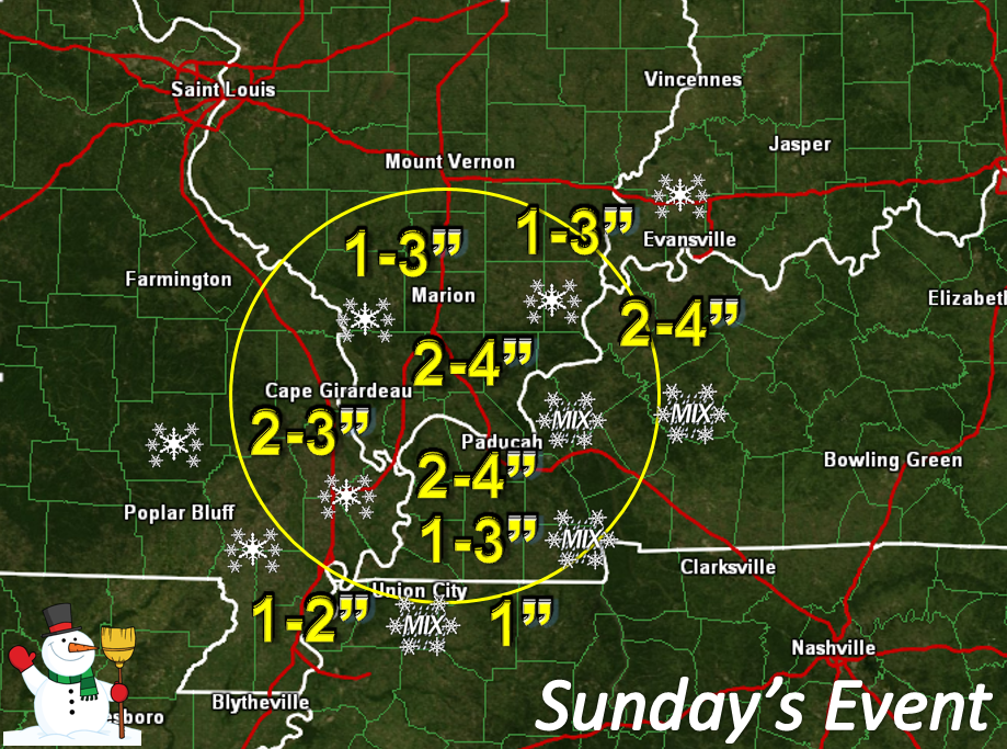
Will not try to get cute with snowfall forecast numbers. Generally speaking, I am forecasting 1″-3″ across the area. As always, someone will be disappointed by their totals and someone will be an over-achiever. Pockets of 3″-4″ of snow are not out of the question where banding occurs. I have placed the best chance of this occurring over our northeast counties (see graphics) and along the Ohio River.
Even at this late hour there remain some questions on snow totals for areas along the Kentucky and Tennessee border. Areas near and east of the Land Between the Lakes. I have marked them with 1″-3″ – but keep in mind, they may remain a wintry mix or just plain rain a bit longer. Some question on that – confidence is lower in that area than say for areas near the Ohio River (where I suspect 1″-3″+ is a good bet).
BITTERLY cold January like air arrives on Monday into Tuesday night. Areas that have a decent covering of snow could dip into the 8 to 14 degree range by Tuesday morning. Winds will blow in the 10-20 mph range. That means wind chills will dip into the single digits. Obviously, as we have witnessed over the last few years, these type of readings can be deadly. Last year we had a death because of an elderly man locked out of his house.
This is a highly unusual weather pattern triggered by intense storm systems out over the Pacific Ocean.
Some schools could be closed on both Monday and Tuesday. Bitterly cold air will help refreeze anything that melts on Monday. This is especially true for untreated roadways and the less traveled roads. Remember that bridges and overpasses generally freeze first.
I am going to post a bunch of graphics. I am not going to spend time on the extended forecast today. Cold temperatures are likely to continue into the weekend. Some additional precipitation chances towards the end of the week. It is too soon to make a call on precipitation type.
If you remember (from my Beau Dodson Weather Facebook Page) I am putting together probability forecasts this year.
I will give you the following information…
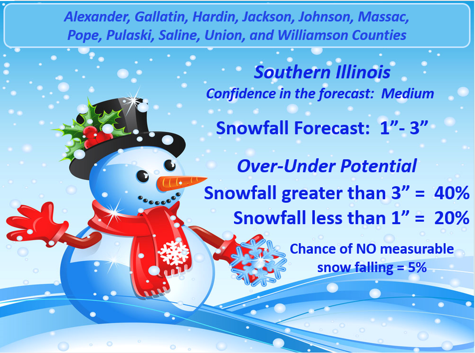
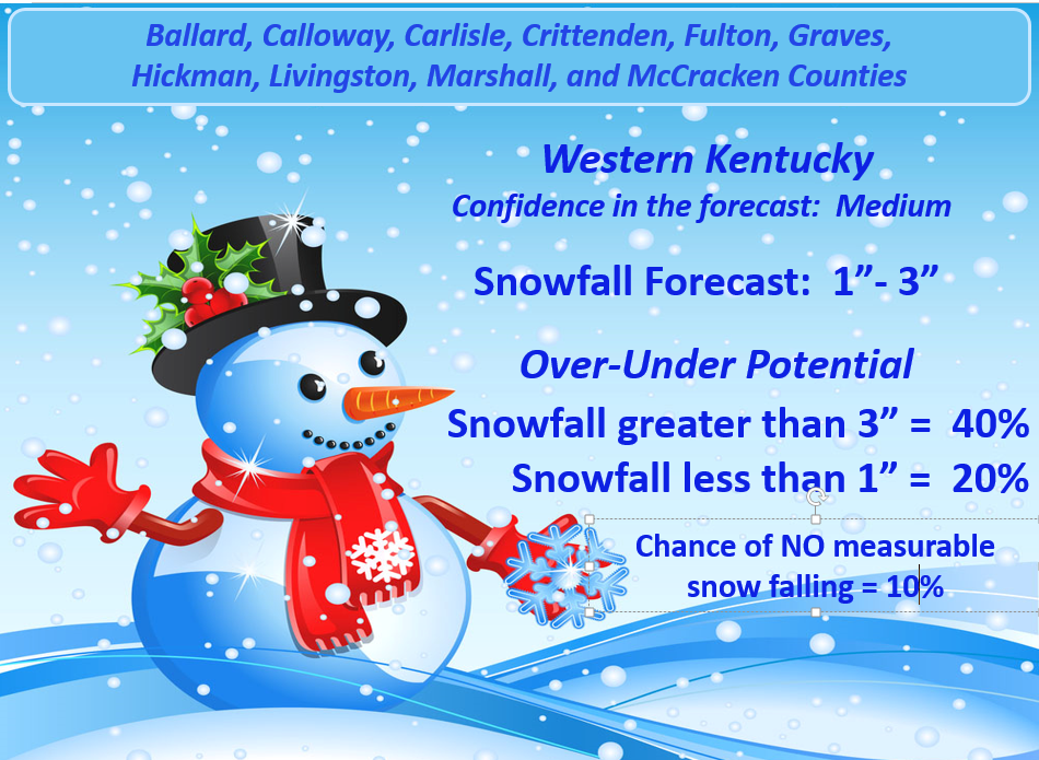
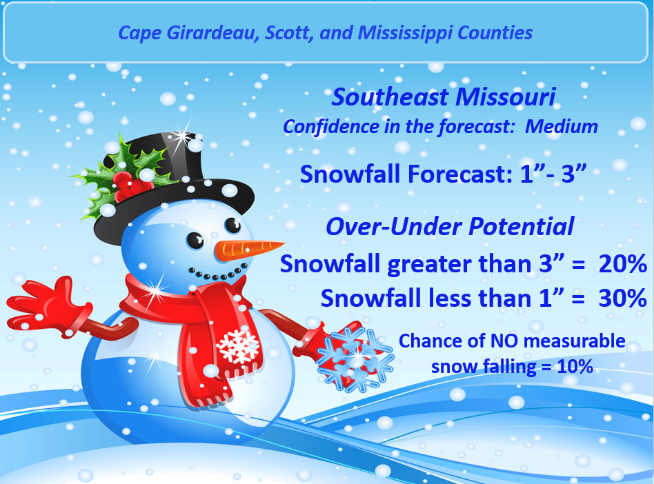
1. My Snowfall Forecast numbers. Those numbers represent how much snow I am expecting.
2. I will then give you the over/under. The over/under represents the chances of snow exceeding my forecast and the chances of snow underachieving my forecast numbers.
3. At the bottom of each graphic I will tell you the probability of the storm being a bust (not producing any measurable snow)
4. These numbers do not have to equal 100%. Keep that in mind.
Just because a % number is fairly low does not mean it won’t happen. If I tell you there is a 30% chance of someone receiving more than 3″ (as an example) then that simply means that a few spots could very well going over 3″
Winter storms are tricky to forecast. There are usually a few surprises.
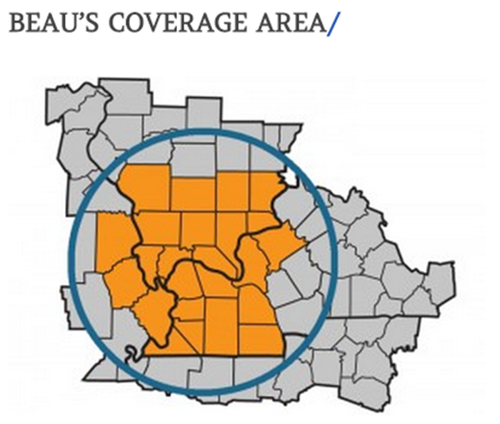
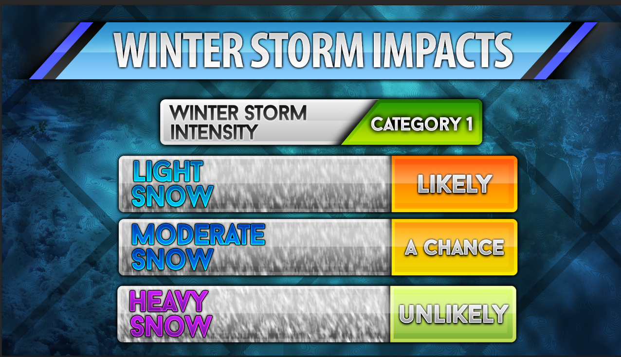
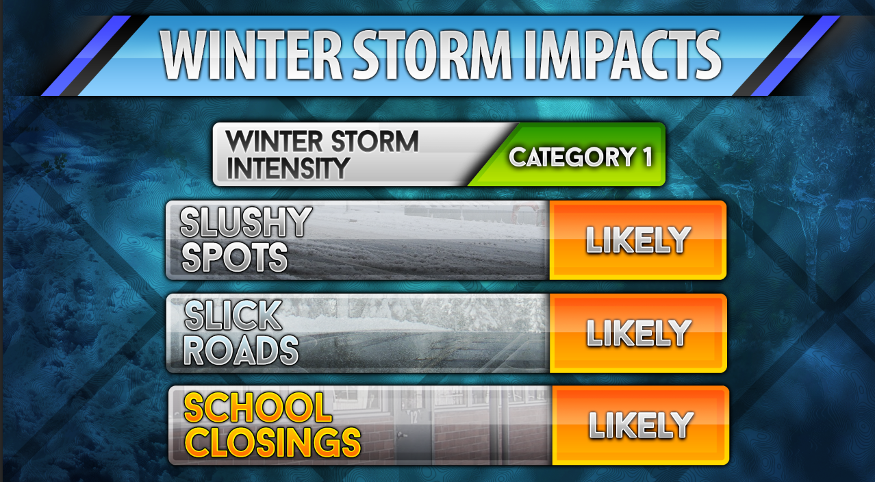
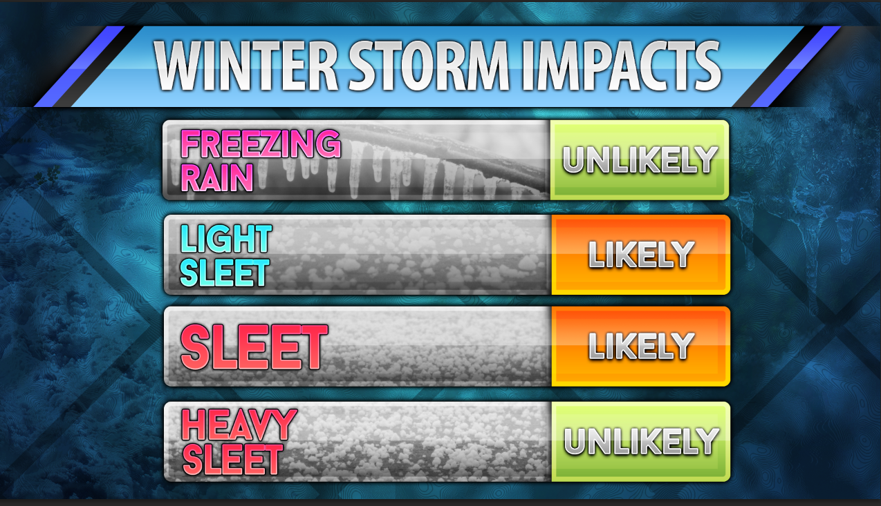
I am also putting together Winter Storm Impact Matrix graphics. This gives you a quick look at what conditions are expected in my forecast counties. The forecast county map shows you the counties that are my main focus (counties in orange)

Winter Storm Impact Matrix for Sunday afternoon/Sunday Night/Monday morning
Current Forecast Numbers
My current forecast numbers with the over/under probabilities
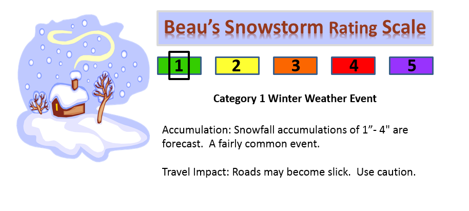
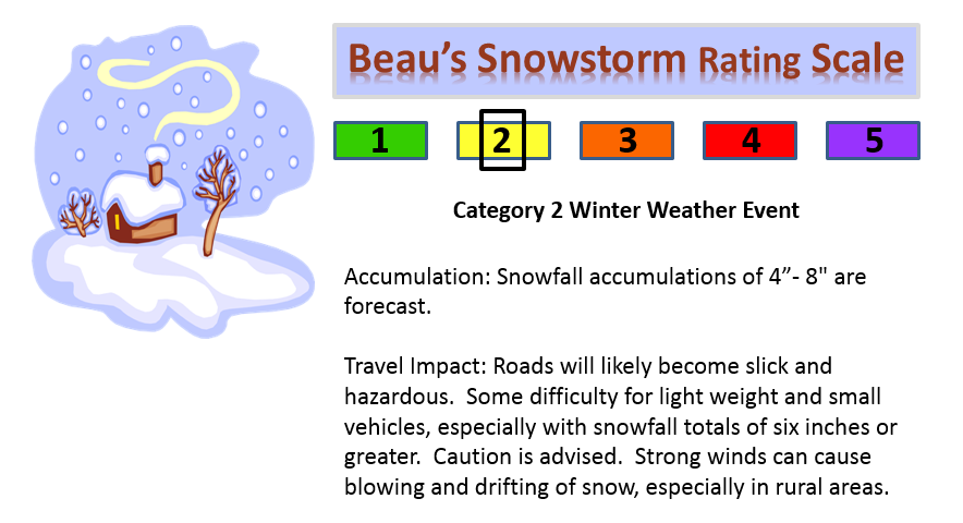
For areas that pick up 4″ or more of snow – this would be a category event. Quite unusual for the middle of November
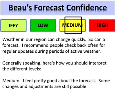
CONFIDENCE LEVEL FOR SUNDAY’S EVENT
The latest official advisories and warnings from the National Weather Service (they are in charge of issuing these products).
Click on the map to drill down to your specific advisory information. The blue area represents a winter weather advisory for later this afternoon into Monday morning.

Some additional maps
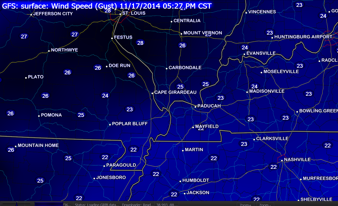
Monday morning wind gust forecast – this will make it feel even colder. Wind chills will be in the single digits and teens.
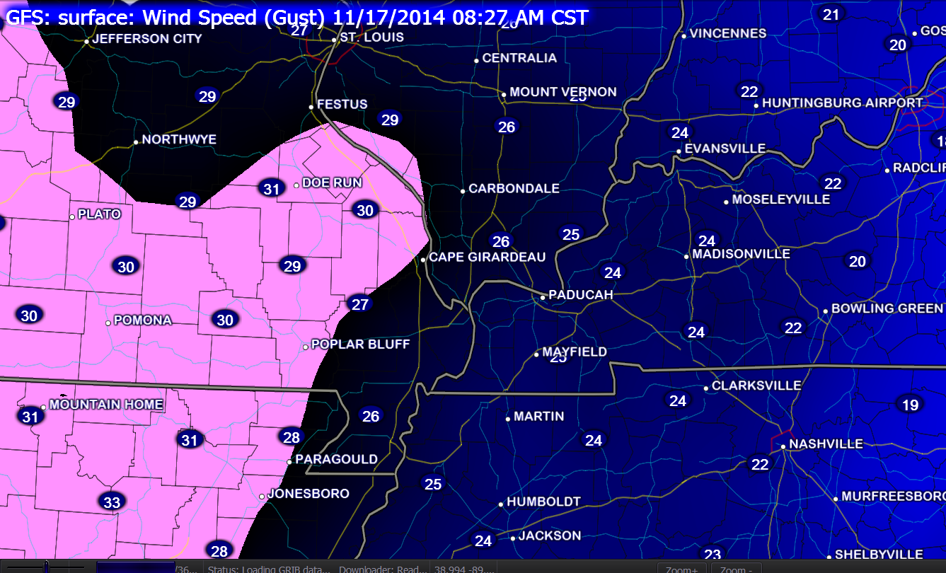
Monday afternoon wind gust map – once again this will make it feel even colder.
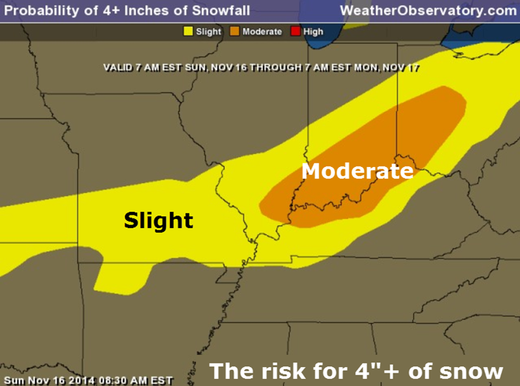
Probability of snowfall reaching 4″ or more – you can see the moderate chances of that happening are in the area I mentioned earlier. Again, some questions surround this topic. We shall see.
Temperatures will be WELL below normal over the coming days. Again, this is more like January than November. A very unusual weather pattern.
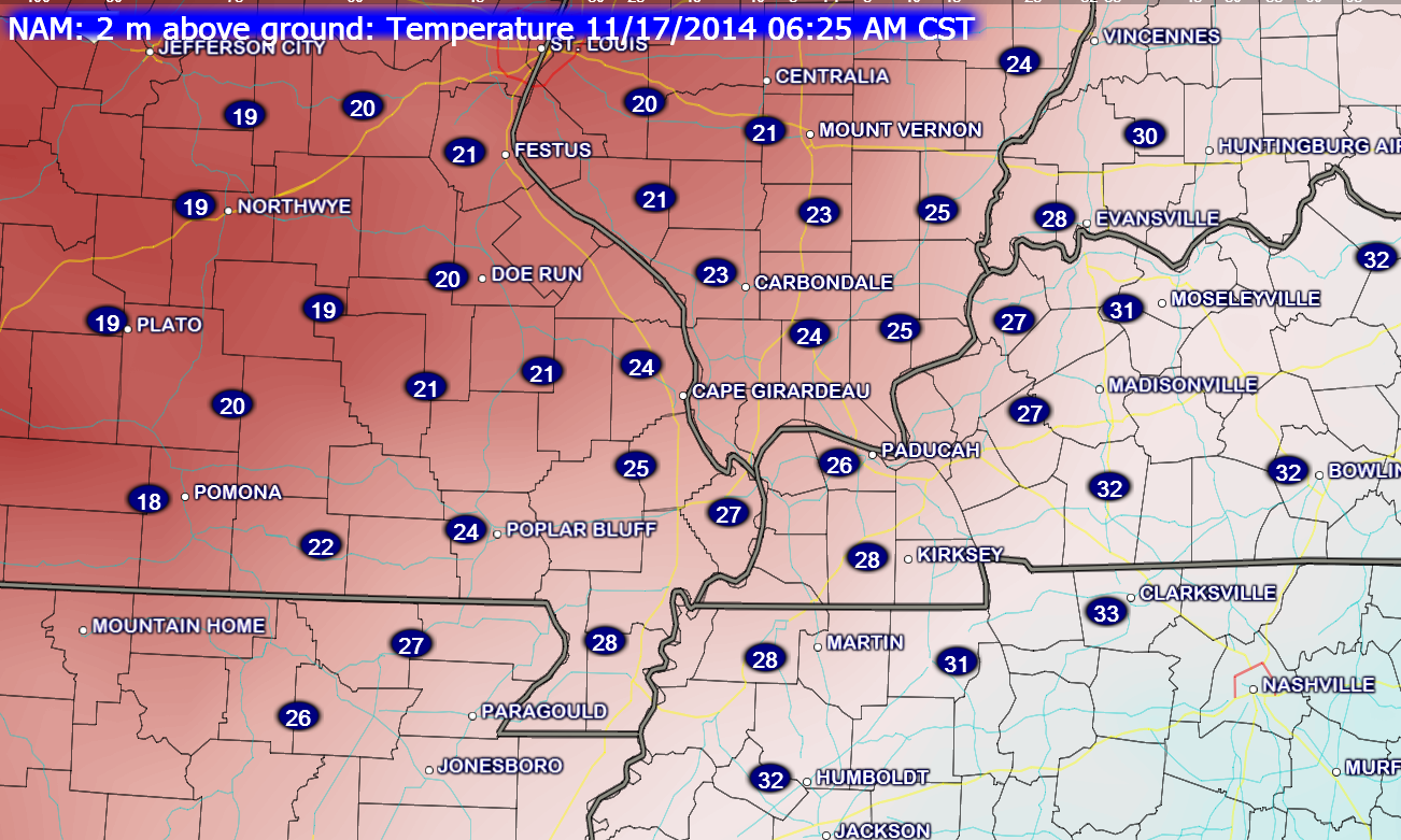
Monday morning temperatures
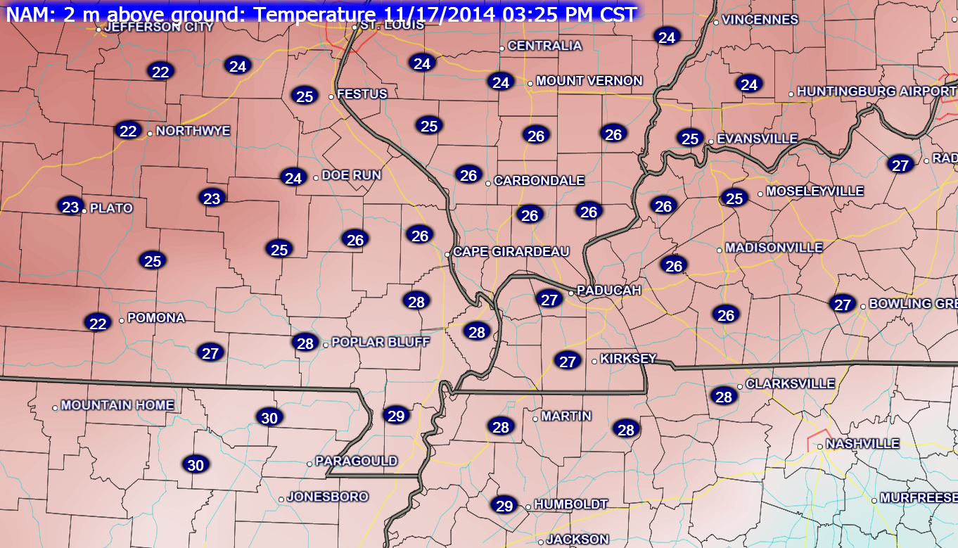
Monday afternoon temperatures
Tuesday morning temperatures. I can’t rule out some single digit readings IF there is a decent snow pack. Winds will be gusty on Monday night. These winds may help keep temperatures above 10 degrees. Either way it is going to be cold.

![]()
We have regional radars and local city radars – if a radar does not seem to be updating then try another one. Occasional browsers need their cache cleared. You may also try restarting your browser. That usually fixes the problem. Occasionally we do have a radar go down. That is why I have duplicates. Thus, if one fails then try another one.
If you have any problems then please send me an email beaudodson@usawx.com
WEATHER RADAR PAGE – Click here —
We also have a new national interactive radar – you can view that radar by clicking here.
Local interactive city radars include St Louis, Mt Vernon, Evansville, Poplar Bluff, Cape Girardeau, Marion, Paducah, Hopkinsville, Memphis, Nashville, Dyersburg, and all of eastern Kentucky – these are interactive radars. Local city radars – click here
NOTE: Occasionally you will see ground clutter on the radar (these are false echoes). Normally they show up close to the radar sites – including Paducah.

Regional Radar – Click on radar to take you our full radar page.


Regional Radar

Current WARNINGS (a warning means take action now). Click on your county to drill down to the latest warning information. Keep in mind that there can be a 2-3 minute delay in the updated warning information.
I strongly encourage you to use a NOAA Weather Radio or warning cell phone app for the most up to date warning information. Nothing is faster than a NOAA weather radio.


Missouri Warnings

Illinois Warnings

Kentucky Warnings
I have added a lot of new maps to the Southern Illinois Weather Observatory web-site. Check them out by clicking here.
Let’s take a look at current temperatures.

The current national temperature map

Your latest IR Satellite. Note some of the milky white areas would be the cold air! IR does pick up one cold air.


Now that we are within 12-18 hours of the snow event…
I have added precipitation to arrive a bit earlier today.
I adjusted the snowfall forecast numbers (adjusted at 1 pm)
I have lowered temperatures on Monday about 5 to 8 degrees cooler than previously forecast.
The NWS has issued winter weather advisories for much of the area. The advisories will for late this afternoon and last into Monday morning. Winter storm warning for a few counties along the Ohio River.
There may be a band of heavier than 3″ of snow across parts of our region. Believe that would mostly occur somewhere near the Ohio River – NW Kentucky perhaps. Still some question on this. I covered this topic in the probability forecast.

Snow and cold. Snow, sleet, and rain will overspread the area late this afternoon and tonight. Rain will change to snow later tonight over western Kentucky.
Bitterly cold air arrives on Monday night. Lows will dip way down into the teens. If we get a solid snow cover then lower teens will be possible. This is very unusual for this time of the year.
Slick roadways will be the concern later tonight and Monday morning. Moisture could also refreeze on roadways Monday night.
Don’t forget about our outdoor pets.

The Wild Card gives you an idea of what might change that would cause the forecast to bust. A busted forecast means a forecast that does not verify. For example, if a winter storm (the area of low pressure) shifts its track 50 miles further south than expected, then that could cause a dramatic change in how much snow might or might not accumulate.
Wild card in this forecast is an obvious one. Where does the slightly heavier snow band develop later tonight. Banding of snow is basically an enhanced area of snow. I am thinking most areas pick up 1″-3″ of snow from this event. There could be some pockets of heavier totals. Thus, the wild card is going to be snowfall totals.

Will I need to take action?
Slick roads are possible tonight and Monday morning. Plan on checking the road conditions tonight into early Monday morning. Untreated roads would be the main concern.
Bitterly cold air Monday into Wednesday. Don’t forget our outdoor friends.

Please visit your local National Weather Service Office by clicking here. The National Weather Service Office, for our region, is located in Paducah, Kentucky.
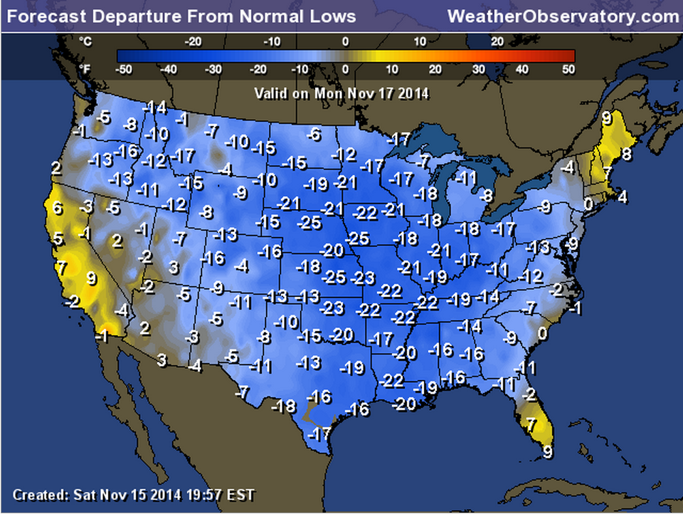
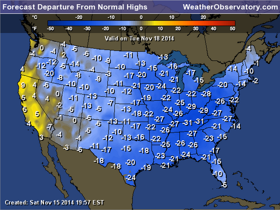
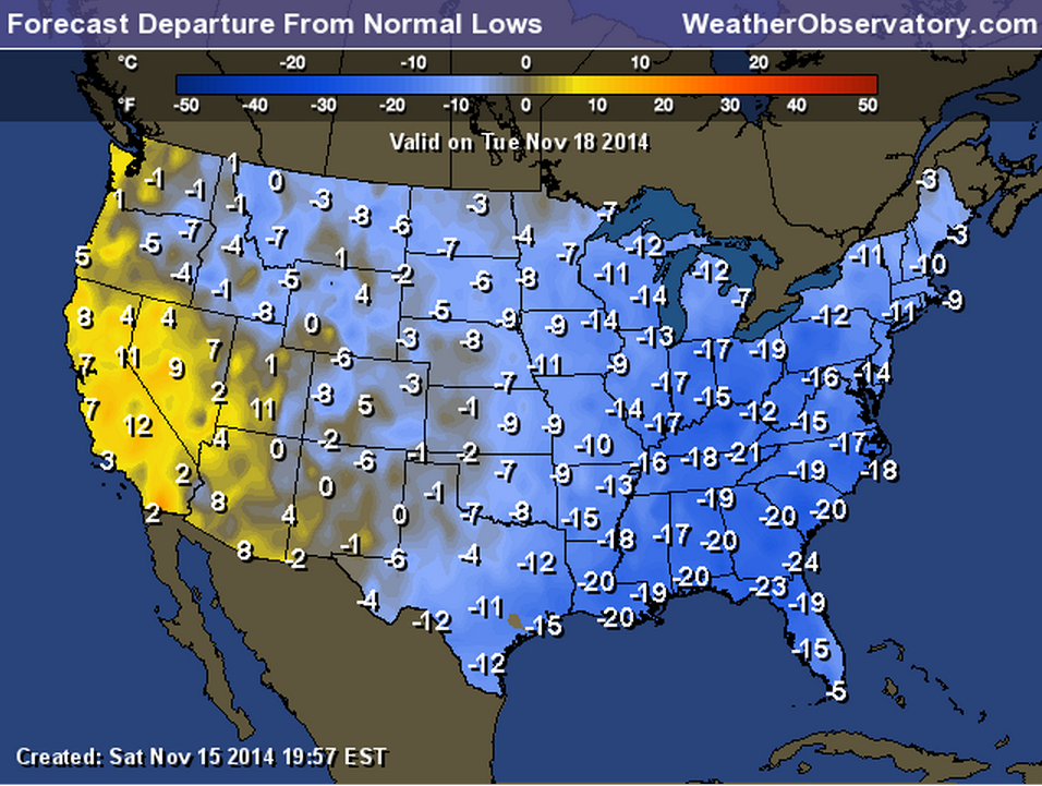
I want to show you just how extreme this cold air mass is. This is more typical of January than November.
These maps show you how many degrees below normal temperatures will be over the coming days. These are not ACTUAL temperatures. The numbers represent how many degrees below the norms will be.
The normal high temperature for this time of the year is around 60 degrees. The normal low temperatures are around 41 degrees.
Monday night’s low temperature departures
Tuesday’s high temperature departures
Tuesday night’s low temperature departures
Current tower cam view from the Weather Observatory- Click here for all cameras.

Southern Illinois Weather Observatory

The Weather Observatory

Southern Illinois Weather Observatory
WPSD TV 6 has a number of tower cameras. Click here for their tower camera page
& Kentucky Road Conditions & Kentucky Highway and Interstate Cameras

Downtown Paducah, Kentucky
Benton, Kentucky Tower Camera – Click here for full view

Benton, Kentucky
WSIL TV 3 has a number of tower cameras. Click here for their tower camera page
& Illinois Road Conditions

Marion, Illinois

You can sign up for my AWARE email by clicking here I typically send out AWARE emails before severe weather, winter storms, or other active weather situations. I do not email watches or warnings. The emails are a basic “heads up” concerning incoming weather conditions.