

November 15, 2014: This forecast update covers far southern Illinois, far southeast Missouri, and far western Kentucky. See the coverage map on the right side of the blog.
Saturday – Partly cloudy. A chance for spotter sleet and light snow. Chilly. High temperatures around 38 degrees. WELL below normal for this time of the year. Southeast winds at 5 mph.
Saturday night – Mostly cloudy. A chance for snow flurries or a period of light snow/sleet. No accumulation expected over far southern Illinois and western Kentucky. Low temperatures will be in the middle to upper 20’s. East/Southeast winds at 10 mph.
Sunday – Increasing clouds through the day. A chance for light snow/sleet or rain late in the day. Cold. High temperatures will be in the lower 40’s – temperatures may be a bit cooler from Poplar Bluff towards Carbondal, Illinois. Southeast winds at 5-10 mph.
Sunday night – Cloudy. Snow, sleet, and rain over far southeast Missouri, far southern Illinois, and western Kentucky. Precipitation may remain all snow over parts of southeast Missouri and southern Illinois. Some accumulation possible. Rain could be mixed with sleet from time to time. Rain will change to snow overnight across the whole area – from to west east. Lows will be in the 25-34 degree range. Coldest air will be over parts of SE MO and southern IL. The 30’s will be over western Kentucky. Temperatures falling into the 20’s for most areas by sunrise. Northwest winds at 5-10 mph.
Monday – Mostly cloudy. Any lingering snow flake will taper by early morning. Cold. Gusty winds. Highs will likely not get out of the 20’s and 30’s. Temperatures may actually fall in the afternoon. Some slick roads possible in areas that experience snow on Sunday night. High temperatures around 30-35 degrees. Wind chills in the teens and 20’s. Northwest winds at 10-25 mph.

An explanation of what is happening in the atmosphere over the coming days.
Well, who is ready for some winter weather? Oh wait, we have already been locked into winter cold for the past week. Well, how about we add some precipitation to the mix?
The main focus for today through Monday will be the chances for snow or rain/snow on Sunday night.
Let’s keep in mind the following
1. Predicting winter weather in our region is always a challenge. There is no such thing as a perfect forecast when it comes to forecasting snowfall totals.
2. Someone always ends up with a bit more and a bit less than expected
3. Predicting the exact timing when the rain changes to snow can be difficult
4. It only takes a little bit of snow to produce slick roads. This is especially true when rain falls before the snow event. This is also especially true when roadways are already cold from previous chilly nights.t
5. Some data does indicate a heavier band of snow across portions of Kentucky. This is a big question mark. Sometimes we end up with banding in snow events like this. Banding can enhance snowfall totals. I won’t get fancy where the placement of where this might occur. Just keep that in mind in case it happens.
SATURDAY’S EVENT…
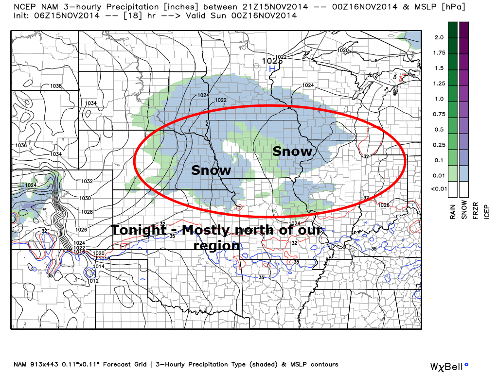
A weak system will move through our region tonight. This will bring some light snow flurries or perhaps a snow shower to the northern parts of our area. Best chances of this happening would be Farmington, Missouri over towards Mt Vernon, Illinois. Areas south of there may not experience much precipitation. No real changes from previous thoughts on that subject.
If any precipitation does occur it would be in the form of snow and sleet. It does not appear this will be a big deal. The main area of lift will be well north of our region. Brief periods of flurries or perhaps a snow shower/sleet shower. If that were to occur then a light dusting in a spot or two would be possible.
SUNDAY’S WINTER WEATHER EVENT…
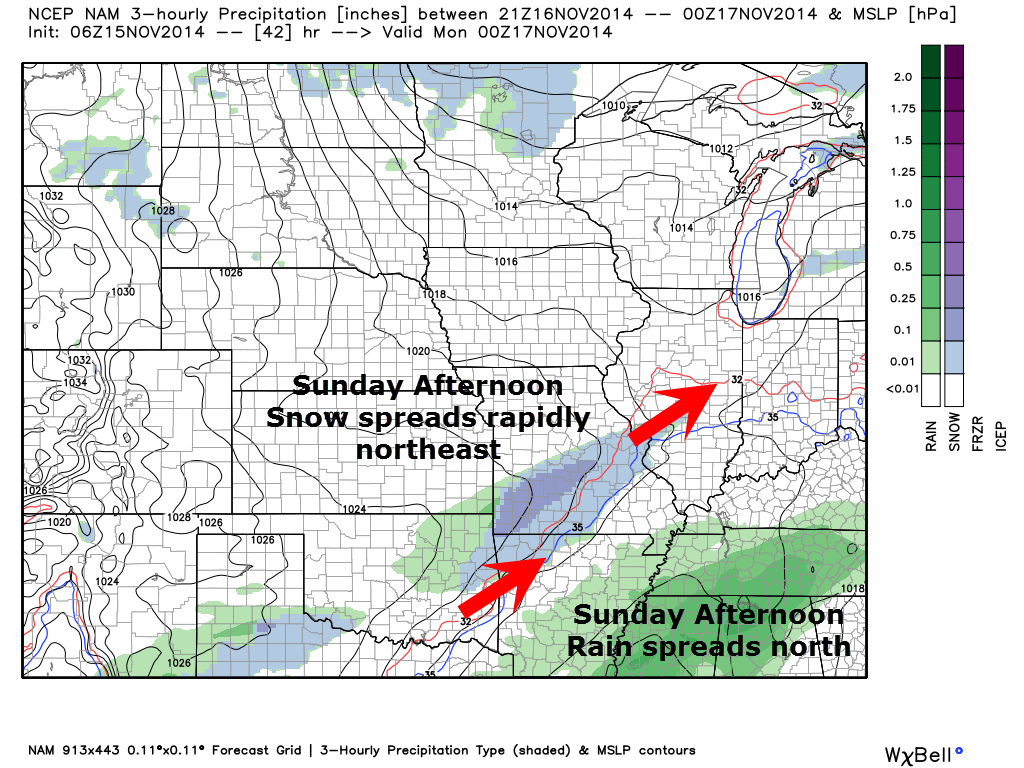
On Sunday a storm system will approach our region from the Gulf of Mexico. This system will have more moisture to work with. It will spread rain and snow across our region by Sunday afternoon and Sunday night.
There is some question as to what time precipitation moves into the area. Right now it appears Sunday afternoon will see an increase in radar returns. That will continue to spread east through the evening hours and into the overnight hours. It is possible that a mix of snow and sleet will begin between 2 pm and 5 pm. The precipitation may start as sleet for far southern Illinois and western Kentucky – then change to a period of rain – then change to all snow. Again, this would occur from west to east as colder air filters into the region.
It appears that mostly snow will occur along a line from near Poplar Bluff and Piedmont, Missouri over towards Carbondale, Illinois and then towards Evansville. Along and north of that line temperatures will be coldest.
Areas to the south of that line will experience a rain/snow mix. Perhaps all rain for awhile over the southern seven counties of southern Illinois and western Kentucky.
Eventually enough cold air will filter in far southern Illinois and western Kentucky to change the rain to snow. Some questions remain on what time that will occur. When that occurs will be crucial to whether a dusting to a few inches of snow will accumulate.
Let’s take a look at some generic radar maps – this is from the NAM model. The NAM model may be a bit too warm with the system. The GFS and EC model are colder. A blend of the models would cut the differences. NAM may hold onto the rain several hours too long. But, let’s just take a look at how the precipitation spreads into the region.
Future-cast radar for this evening. You can see system one skirting to our north (for the most part)
Sunday Afternoon Future-cast Radar – snow is spreading across portions of Missouri. Rain is spreading northward from the southlands. Some sleet is likely mixed in with the precipitation.
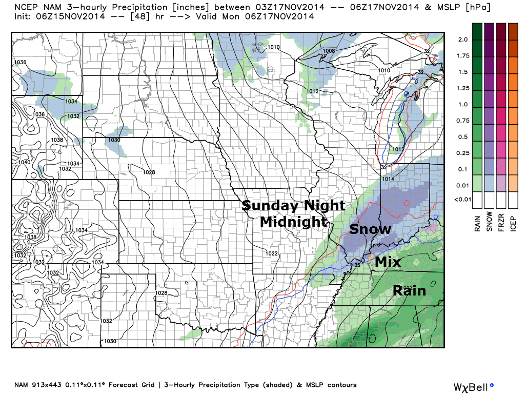
Sunday Evening – Snow, sleet, and rain have overspread our entire region.
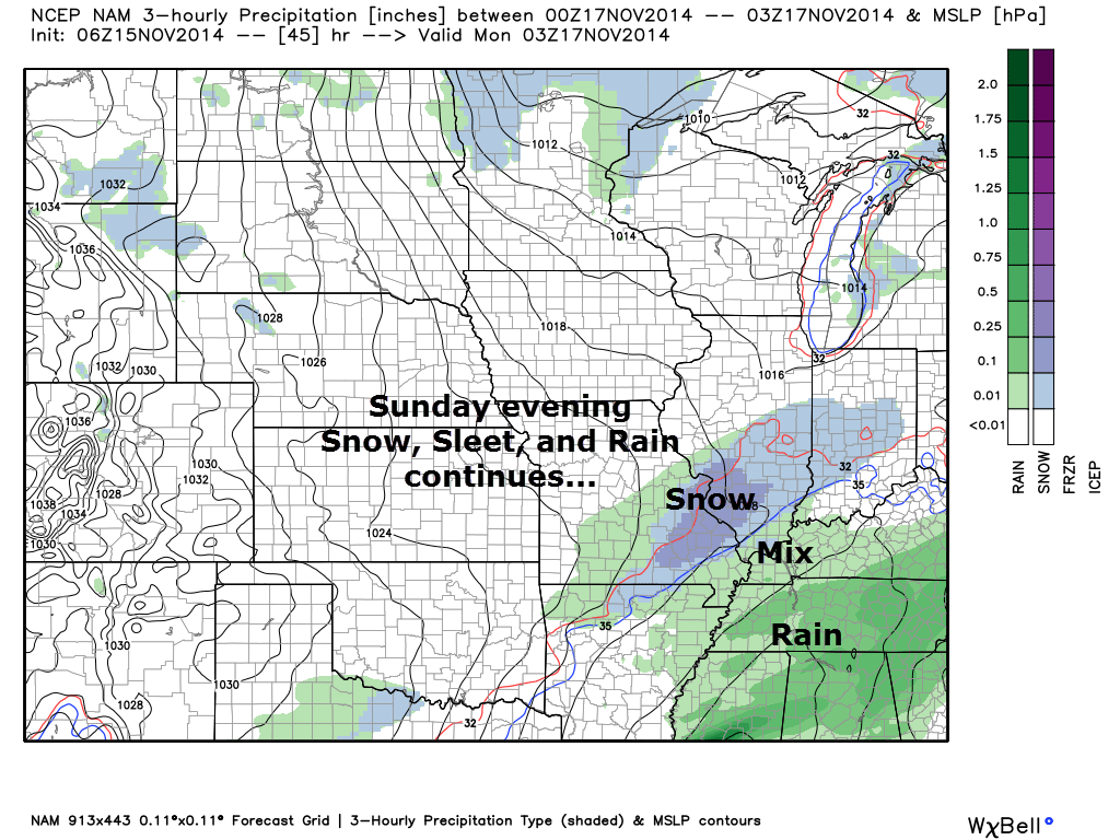
Here is another visualization of the future-cast radar for the 8 pm – 10 pm time frame. The blue represents snow. The green represents a mix of rain, sleet, and snow. This just gives you an idea of how tight the rain/snow line will likely be…at least for a few hours. The bright yellow colors is the change-over region. Again, this is the NAM model and it may be a bit too slow in changing the rain to snow. We shall see.
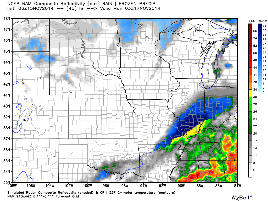
Monday Morning at 1 AM – Snow covers most of the region. Perhaps still rain over our far eastern or southeast counties. Rain will change to snow everywhere at some point Sunday night.
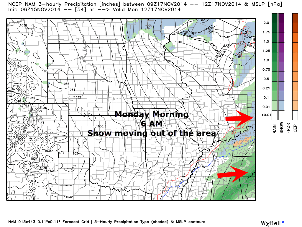
Monday Morning – 7 AM radar indicates snow ending over the area.
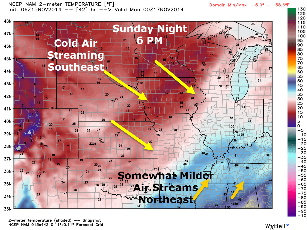
Let’s take a look at temperatures on Sunday evening vs Monday morning – you can see the cold air to the northwest sinking into our region. Temperatures will fall into the 20’s by Monday morning over most of our region. Some school closings will be possible.
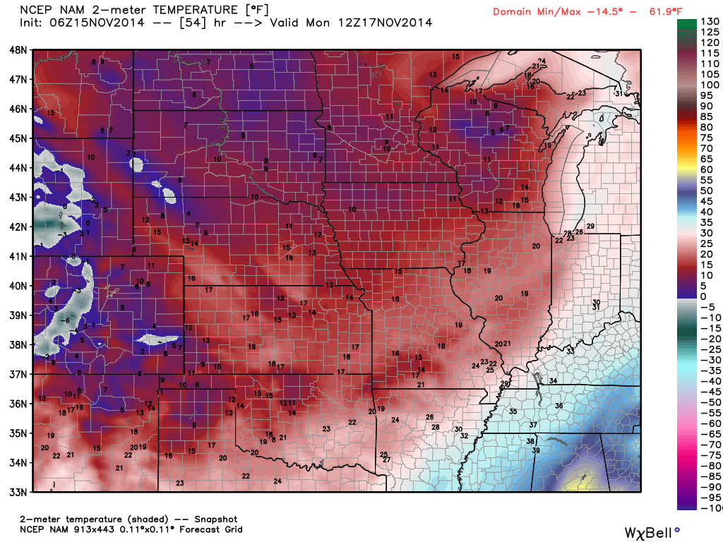
Now let’s look at Monday morning temperatures. Notice how the colder air has filtered into our counties? That pink/red area represents 20’s. BRRR! Strong and gusty winds on Monday will make it feel even colder.
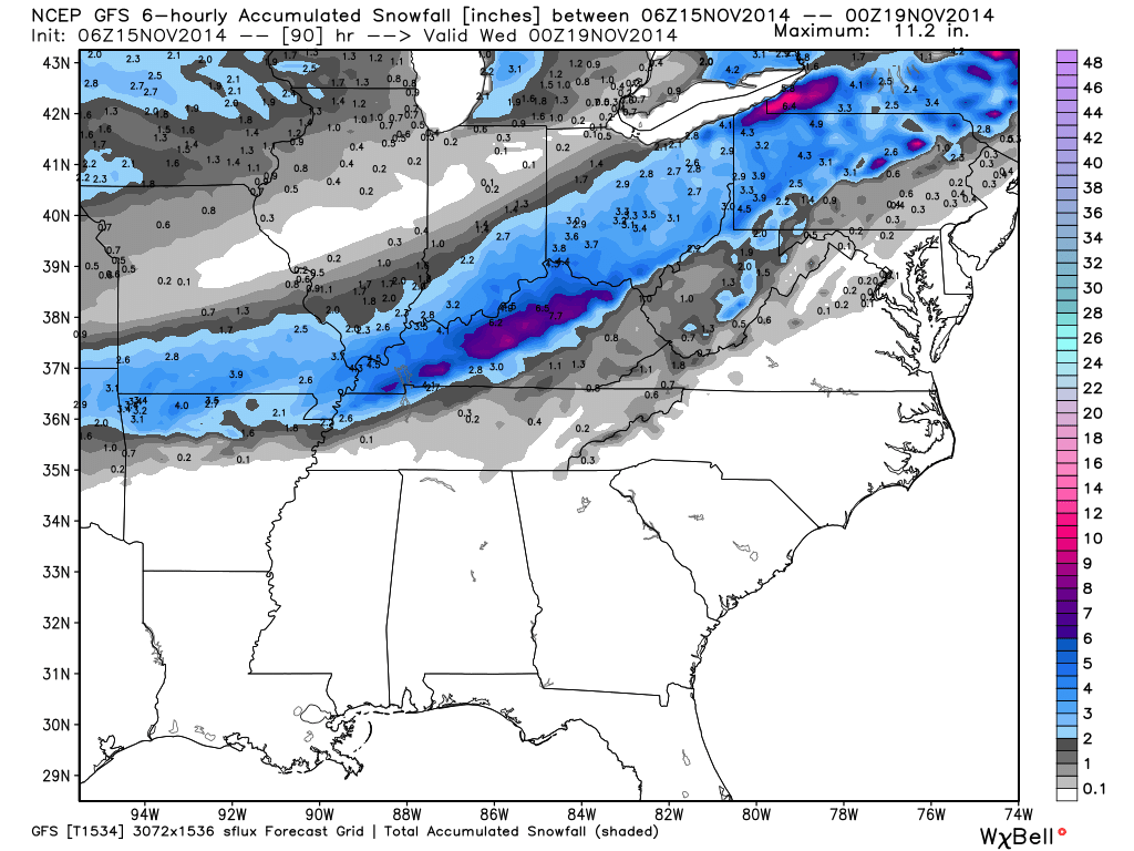
Snowfall totals should be in the 1″-3″ range by Monday morning over most of our region. Again, some counties may pick up less and some a tad more. How much snow falls will be highly dependent on exactly what time the rain changes to snow.
Here is the GFS model and its idea on snowfall totals. This is the new high resolution model. It has been consistent on putting down this band of snow in our region. Keep in mind the GFS is one of the colder solutions. Thus it keeps precipitation snow the longest.
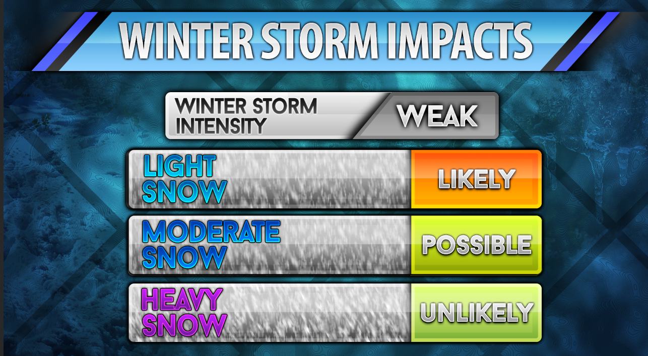
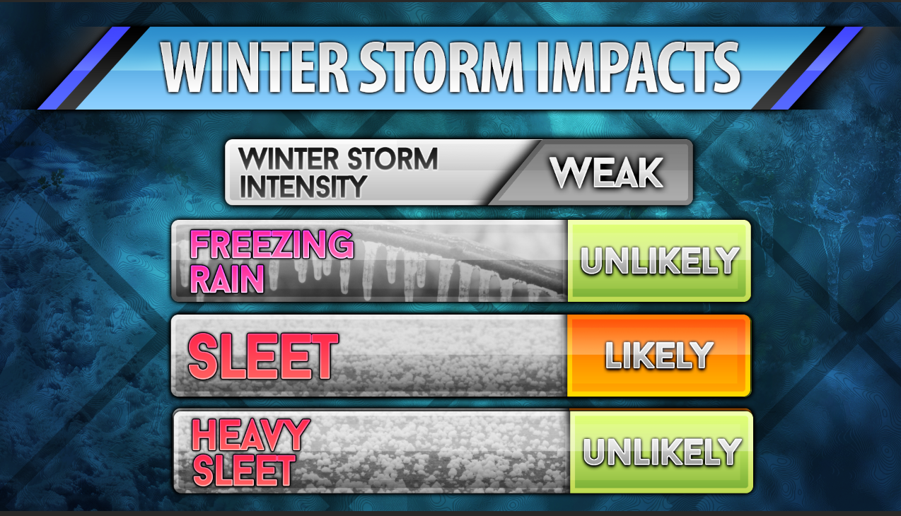
Winter Storm Impact Matrix for Sunday afternoon/Sunday Night/Monday morning
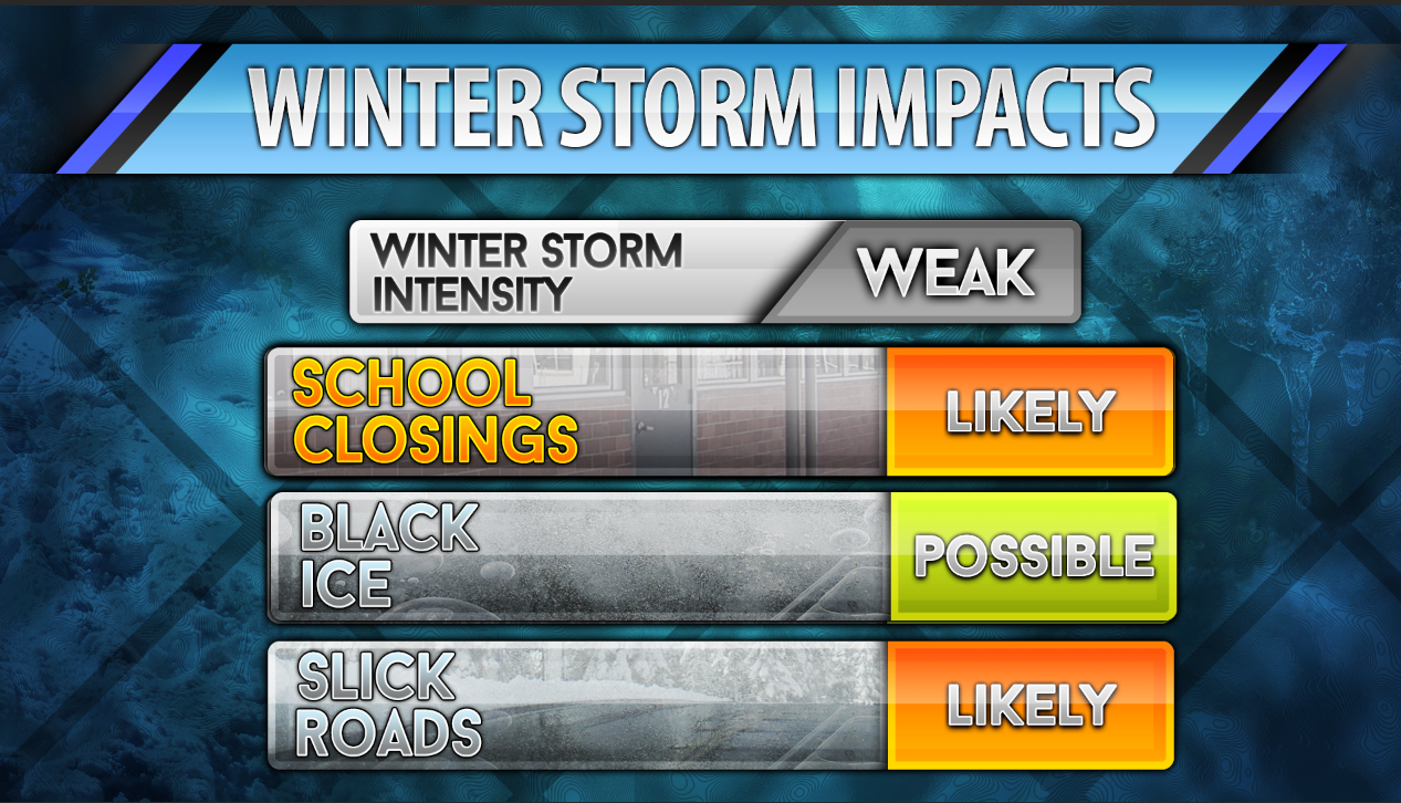
Winter Storm Impact Matrix for Sunday afternoon/Sunday Night/Monday morning
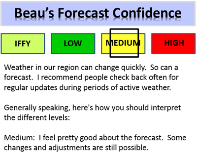
CONFIDENCE LEVEL FOR SUNDAY’S EVENT
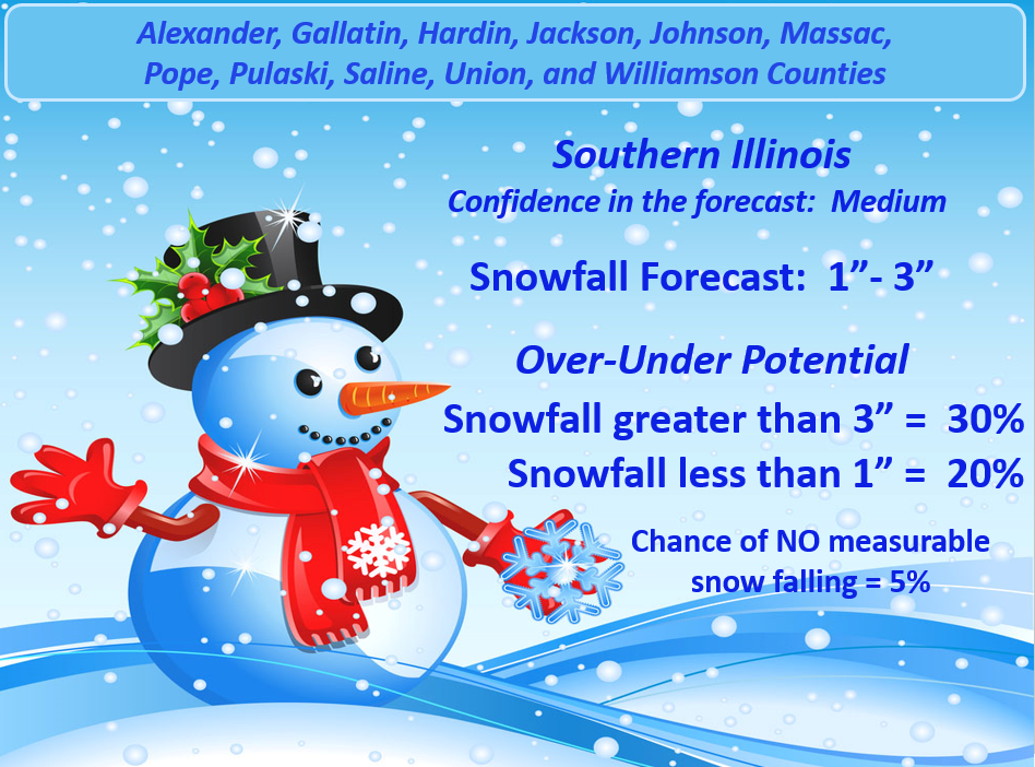
Here is my snowfall forecast for southern Illinois.
1. 1″-3″ of snow for southern Illinois
2. There is a 30% chance of exceeding that amount
3. There is only a 20% chance of less than 1″ of snow falling.
4. There is only a 5% chance of no snow at all.
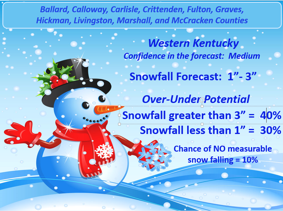
Here is my snowfall forecast for western Kentucky
I did place a bit higher probability on less than 1″ of snow falling. I did this because I am little uncertain as to how soon the rain changes to snow. I feel pretty good that 1″-3″ will fall. Those are my official forecast numbers.
1. 1″-3″ of snow for western Kentucky
2. There is a 40% chance of exceeding that amount
3. There is a 30% chance of less than 1″ of snow falling.
4. There is only a 10% chance of no snow at all.
There is some question about a slightly heavier band of snow occurring somewhere in western and central Kentucky. Keep that in mind.
Much colder air arrives again on Monday into Monday night. Lows by Tuesday morning will be in the teens. Brrrr will be the word.
Gusty winds on Monday and Tuesday will cause the wind chill temperature to dip down into the single digits and teens. Not the best weather for the middle of November.
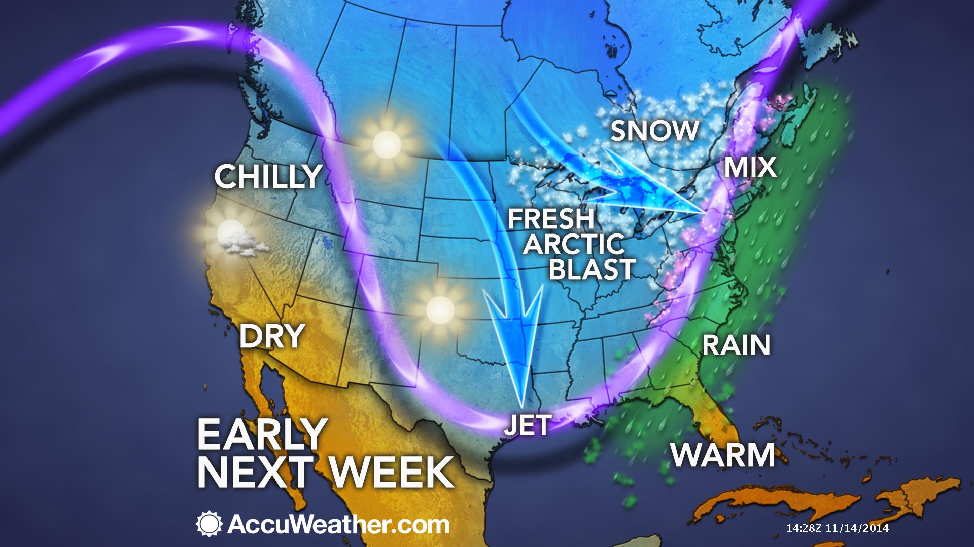
This graphic sums it all up. Most of the nation is experiencing this cold blast.
Let’s take a look at current temperatures.

The current national temperature map

Your latest IR Satellite. Note some of the milky white areas would be the cold air! IR does pick up one cold air.


The weekend precipitation makers are coming into better focus. I have not made any significant changes to the Saturday night forecast. Still appears that snow chances will be quite limited tonight. Some sleet may mix in at times.
I have started to zero in on the Sunday night system. Changes are likely to occur for that event. Temperatures will likely need to be adjusted as we move forward. Where the snow/rain line is placed will need to be monitored. Expect some forecast changes to occur between now and tomorrow afternoon. Stay tuned if you have concerns about Monday morning travel.

Some light snow/sleet or flurries tonight. No major concerns for our immediate local counties (see my forecast counties on the right side of the page).
Bigger concerns arrive Sunday night. A rain and snow event is forecast to overspread our region. This will likely cause some travel issues by Monday morning. Specifics are still being ironed out. Best chances for accumulating snow will likely be over parts of southeast Missouri and southern Illinois.
There might be some school closings in the region on Monday.

The Wild Card gives you an idea of what might change that would cause the forecast to bust. A busted forecast means a forecast that does not verify. For example, if a winter storm (the area of low pressure) shifts its track 50 miles further south than expected, then that could cause a dramatic change in how much snow might or might not accumulate.
Wild card in this forecast will be snowfall totals on Sunday night. A lot of questions remain on temperatures Sunday evening. I believe temperatures will be too warm for snow over parts of far southeast Missouri, far southern Illinois, and far western Kentucky. At least that will be true at the beginning of the precipitation. Rain will change to snow overnight on Sunday. The wild card is what time does the rain change to snow.

Can we expect severe thunderstorms over the next 24 to 48 hours? Remember that a severe thunderstorm is defined as a thunderstorm that produces 58 mph winds or higher, quarter size hail or larger, and/or a tornado.
Severe weather is not going to be a concern through Wednesday.
Thunderstorm threat level is zero.


Will I need to take action?
If you are traveling north into parts of central and eastern Missouri or central and northern parts of southern Illinois then check travel conditions late tonight. Some light snow is forecast to our north.
Otherwise, a period or two of light snow and sleet may occur over the area this afternoon and tonight. No significant accumulation expected.
Slick roads are possible Sunday night and Monday morning. This would most likely occur over parts of southeast Missouri and southern Illinois. The later we push into the night the more likely there will be some road issues over western Kentucky. This is highly dependent on what time the rain changes to snow. Plan on checking the road conditions early Monday morning. Untreated roads would be the main concern.
Still time for adjustments in the forecast.

Please visit your local National Weather Service Office by clicking here. The National Weather Service Office, for our region, is located in Paducah, Kentucky.

Some light snow/sleet or flurries will be possible late tonight (Saturday night). Should not be a big deal for our immediate local counties.
A better chance of rain, sleet, and snow will occur on Sunday afternoon into Monday morning. Check back for updates concerning the specifics on the rain/snow line…as more data becomes available.
Always keep in mind, that if road temperatures are cold and a little bit of moisture falls on untreated roads then there could be a few slick spots. This is especially true for bridges and overpasses.
Another chance for snow arrives on Sunday afternoon/night. Rain/sleet will begin over far southeast Missouri, far southern Illinois, and western Kentucky between 3 pm and 5 pm. The rain will first change to snow over parts of southeast Missouri and southern Illinois. Rain will linger the longest over the southern most counties of southern Illinois and western Kentucky.
Rain will change to snow on Sunday night into Monday morning. I believe the best chance for accumulating snow (early on) will be over parts of southeast Missouri and southern Illinois. This would likely be along a line from near Poplar Bluff and Piedmont, Missouri then east/northeast towards Carbondale, Illinois/ Du Quoin, Illinois then east. Areas along that line should be mostly snow. Areas south and southeast of that line should be a rain/snow mix changing to snow.
Snow accumulation will begin over far far southern Illinois and western Kentucky as we push into the overnight hours on Sunday. Still some questions on the exact change-over time.
At this time, subject to change, it appears that 1″-3″ of snow will be possible in areas that precipitation remains mostly snow.
In areas that remain rain for a longer period of time will not experience as much snow accumulation.
The southern seven counties in Illinois and western Kentucky are the most questionable areas for snowfall accumulations. I am more confident in areas north of that line.
Stay tuned for updates if you have concerns. Some slick roads are possible by Monday morning (with temperatures falling into the 20’s)

See above for the snow discussion…
Bitterly cold air will arrive on Monday and last into Tuesday/Wednesday. In areas that pick up a little snow you can expect lows well down into the teens by Tuesday morning.
Quite the amazing run of cold temperatures. It is very unusual to experience cold temperatures like this (for an extended period of time) in the middle of November.
There are some signals for precipitation towards Thursday and Friday of this week. By then we should warm up enough for a rain event (although some data indicates a wintry mix – stay tuned). I will monitor as we move forward. I have not spent too much time on the long range. More focused on these weekend events.
The latest 6-10 day temperature and precipitation outlook. Will temperatures be ABOVE or BELOW normal?


The latest 8-14 day temperature and precipitation outlook. Note the dates are at the top of the image. These maps simply give you the probability as to whether temperatures or precipitation will be above or below normal.


Current tower cam view from the Weather Observatory- Click here for all cameras.

Southern Illinois Weather Observatory

The Weather Observatory

Southern Illinois Weather Observatory
WPSD TV 6 has a number of tower cameras. Click here for their tower camera page
& Kentucky Road Conditions & Kentucky Highway and Interstate Cameras

Downtown Paducah, Kentucky
Benton, Kentucky Tower Camera – Click here for full view

Benton, Kentucky
WSIL TV 3 has a number of tower cameras. Click here for their tower camera page
& Illinois Road Conditions

Marion, Illinois

You can sign up for my AWARE email by clicking here I typically send out AWARE emails before severe weather, winter storms, or other active weather situations. I do not email watches or warnings. The emails are a basic “heads up” concerning incoming weather conditions.