We have some great sponsors for the Weather Talk Blog. Please let our sponsors know that you appreciate their support for the Weather Talk Blog.
Milner and Orr Funeral Home and Cremation Services located in Paducah, Kentucky and three other western Kentucky towns – at Milner and Orr they believe in families helping families. You can find Milner and Orr on Facebook, as well.
![]()

.

Wortham Dental Care located in Paducah, Kentucky. The gentle dentist. Mercury free dentistry. They also do safe Mercury removal. You can find Wortham Dental Care on Facebook, as well
.

For all of your families eye care needs. Visit their web-site here. Or, you can also visit their Facebook page.
.

Endrizzi’s Storm Shelters – For more information click here. Endrizzi Contracting and Landscaping can be found on Facebook, as well – click here
.

Best at Enabling Body Shop Profitability since 1996. Located In Paducah Kentucky and Evansville Indiana; serving all customers in between. They provide Customer Service, along with all the tools necessary for body shops to remain educated and competitive. Click the logo above for their main web-site. You can find McClintock Preferred Finishes on Facebook, as well
.

Duck/goose decoys? Game calls? Optics? We have you covered! Click the logo above or visit Final Flight on Facebook, as well.

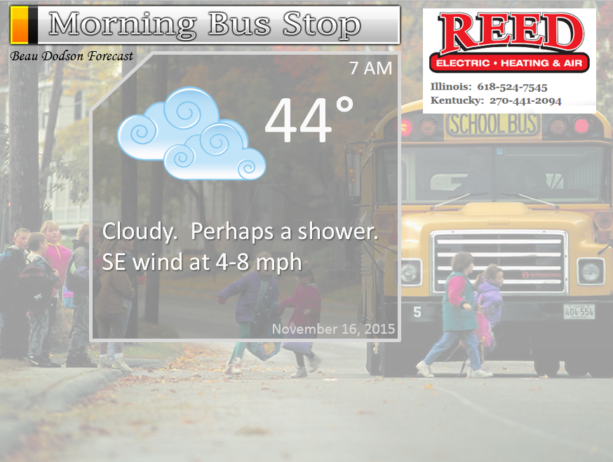
This forecast update covers far southern Illinois, far southeast Missouri, and far western Kentucky. See the coverage map on the right side of the blog.
Remember that weather evolves. Check back frequently for updates, especially during active weather.
Sunday night – Becoming cloudy. A chance for a shower late at night. Most likely over southeast Missouri and perhaps southwest Illinois.
Temperatures: Lows in the upper 30s to lower 40s
Winds: South and southeast winds at 3-6 mph
What is the chance for precipitation? 20% eastern counties and 60% for western counties (southeast Missouri and southwest Illinois)
Coverage of precipitation? Scattered, perhaps
My confidence in this part of the forecast verifying is medium
Should I cancel my outdoor plans? No
Is severe weather expected? No
What impact is expected? Maybe some wet roadways
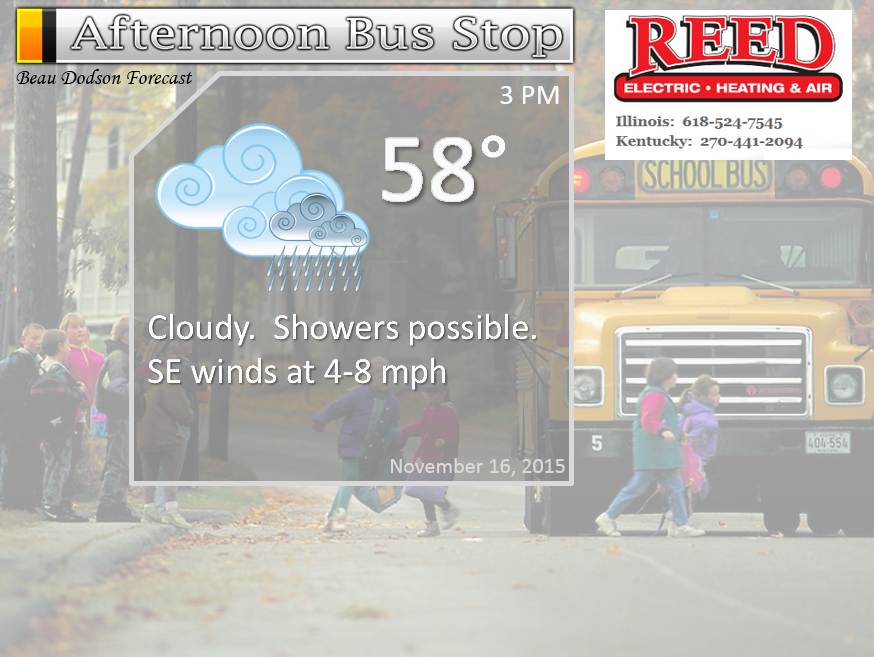
Monday – Cloudy. Rain showers likely before noon over at least southeast Missouri. Rain showers will spread eastward into the day. Still some question about how fast precipitation moves into southern Illinois and western Kentucky. But, they could spread in before noon in those areas, as well. Eastern counties in western Kentucky would be a bit later.
Temperatures: Highs in the upper 50s to lower 60s.
Winds: Southeast winds at 5-10 mph. Gusts to 15-20 mph possible late in the day.
What is the chance for precipitation? 90%-100%
Coverage of precipitation? Scattered to perhaps widespread at times
My confidence in this part of the forecast verifying is High
Should I cancel my outdoor plans? Have a plan B – especially for the afternoon hours. A little uncertain on the morning hours.
Is severe weather expected? No
What impact is expected? Wet roadways
A reminder…eastern counties may not see much rain accumulation (compared with western counties) until the front arrives. That would be Evansville down to Hopkinsville. Perhaps more in Evansville earlier on vs Hopkinsville.
I have noted some data showing very little rain over our southeastern counties until the front on Tuesday night.
Monday night – Cloudy. Rain likely.
Temperatures: Lows in the middle to upper 40s.
Winds: South and southeast winds at 8-16 mph with gusts to 20 mph
What is the chance for precipitation? 60%-80%
Coverage of precipitation? Widespread
My confidence in this part of the forecast verifying is High
Should I cancel my outdoor plans? Have a plan B
Is severe weather expected? No
What impact is expected? Wet roadways
Tuesday – Cloudy. Some showers possible. We could have somewhat of a lull in precipitation during part of Tuesday.
Temperatures: Highs in the 64 to 68 degree range.
Winds: South/southeast winds at 12-24 mph. Gusty winds possible.
What is the chance for precipitation? 60%, but a lull in precipitation is possible on Tuesday before a heavier rain band moves in on Tuesday night
Coverage of precipitation? Scattered to perhaps widespread
My confidence in this part of the forecast verifying is Medium
Should I cancel my outdoor plans? Have a plan B in case we do have widespread rain
Is severe weather expected? No
What impact is expected? Wet roadways.
Tuesday night – Cloudy. Rain likely. Perhaps heavy at times especially late at night.
Temperatures: Lows in the middle to upper 50s.
Winds: South and southeast winds at 8-16 mph. Gusty at times. Winds becoming south and southwest after midnight at 5-10 mph.
What is the chance for precipitation? 100%
Coverage of precipitation? Widespread
My confidence in this part of the forecast verifying is High
Should I cancel my outdoor plans? Have a plan B
Is severe weather expected? No, but gusty winds possible
What impact is expected? Wet roadways. Perhaps some pockets of water over roadways from ditches. Low risk for flooding. Risk is not zero.
Wednesday – Cloudy. Rain showers ending early in the day. Rain ending from west to east. Should be a sharp cutoff on radar as the front moves through the region. Perhaps becoming partly sunny in the afternoon.
Temperatures: Highs in the lower 60s.
Winds: South/southwest winds at 8-16 mph. Gusts to 20 mph possible.
What is the chance for precipitation? 80% before 6 am. Then dropping to 20% by the lunch hour.
Coverage of precipitation? Scattered to widespread early.
My confidence in this part of the forecast verifying is Medium
Should I cancel my outdoor plans? Believe the rain will end by the morning hours.
Is severe weather expected? No
What impact is expected? Wet roadways.
Wednesday night – A few clouds. Otherwise, clearing sky conditions and cool.
Temperatures: Lows in the 38 to 44 degree range
Winds: Southwest winds at 6-12 mph with gusts to 15 mph
What is the chance for precipitation? 0%
Coverage of precipitation? None
My confidence in this part of the forecast verifying is High
Should I cancel my outdoor plans? No
Is severe weather expected? No
What impact is expected? None
Thursday – Partly sunny.
Temperatures: Highs in the upper 50s to lower 60s
Winds: Southwest winds at 4-8 mph.
What is the chance for precipitation? 0%
Coverage of precipitation? None
My confidence in this part of the forecast verifying is High
Should I cancel my outdoor plans? No
Is severe weather expected? No
What impact is expected? None
Thursday night – Mostly clear. Chilly. Frost possible. Perhaps a freeze.
Temperatures: Lows in the lower to middle 30s.
Winds: North winds at 5 mph
What is the chance for precipitation? 0%
Coverage of precipitation? None
My confidence in this part of the forecast verifying is High
Should I cancel my outdoor plans? No
Is severe weather expected? No
What impact is expected? Frost/freeze
Friday – Partly sunny.
Temperatures: Highs in the upper 50s to around 60 degrees.
Winds: North winds at 4-8 mph.
What is the chance for precipitation? 0%
Coverage of precipitation? None
My confidence in this part of the forecast verifying is High
Should I cancel my outdoor plans? No
Is severe weather expected? No
What impact is expected? None
Friday night – Mostly clear. Cold.
Temperatures: Lows in the middle 30s.
Winds: Southeast winds at 5 mph
What is the chance for precipitation? 0%
Coverage of precipitation? None
My confidence in this part of the forecast verifying is Medium
Should I cancel my outdoor plans? No
Is severe weather expected? No
What impact is expected? Frost possible
Saturday – Partly sunny.
Temperatures: Highs in the middle 50s
Winds: Southwest winds at 4-8 mph.
What is the chance for precipitation? 0%
Coverage of precipitation? None
My confidence in this part of the forecast verifying is Medium
Should I cancel my outdoor plans? No
Is severe weather expected? No
What impact is expected? None
Click their ad below to visit their web-site or click here reedelec.com


![]()


Don’t forget to check out the Southern Illinois Weather Observatory web-site for weather maps, tower cams, scanner feeds, radars, and much more! Click here

An explanation of what is happening in the atmosphere over the coming days…
Highlights
1. Rain enters the picture late Sunday night into Monday morning
2. Rain overspreads the region on Monday and Monday night.
3. Heaviest rainfall should be on Tuesday into Wednesday morning
4. How much rain will fall and where?
5. Severe weather is not anticipated.
I hope you enjoyed your Sunday.
The big weather story is of course the rain that will push into our region on Sunday night and Monday morning. Rain will pick up in intensity on Monday night and early Tuesday morning. Some indications of a lull at some point late Tuesday morning or afternoon. Although, confidence is lower on this part of the forecast.
Rain is already falling over parts of southwest Missouri (as of this typing early Sunday afternoon). Clouds and rain will spread east/northeast into our local counties on Monday morning. Eastern counties may have to wait a bit longer for the precipitation to arrive. As a matter of fact, some of our eastern counties in western Kentucky may not see a lot of rainfall accumulation until the main cold front on Tuesday night and Wednesday morning. Yes, it will rain there before Tuesday night, but just not as much as say southeast Missouri and southwest Illinois.
We should experience two time periods where moderate to heavy rain will be more likely. One on Monday night and another on Tuesday night. Tuesday night providing the heaviest rain. More than half of this systems rain may fall on Tuesday night and Wednesday morning.
Strong forcing along the front coupled with very high PWAT values will produce torrential downpours on Tuesday night/Wednesday morning. This would be the time frame where some ditches would most likely overflow and some ponding of water issues could occur.
Light to moderate rain will be the general rule on Monday into Tuesday morning. Again, perhaps a period of heavy rain,as well, on Monday night. Then perhaps a lull in the system during the late morning hours and afternoons hours on Tuesday. Then the rain will pick up again on Tuesday night/Wednesday morning. Keep that in mind. It is not going to rain all the time from Monday morning through Wednesday morning. Although our western counties from Poplar Bluff, Missouri towards Perryville, Missouri and then into southwest Illinois may see more hours with rain than without.
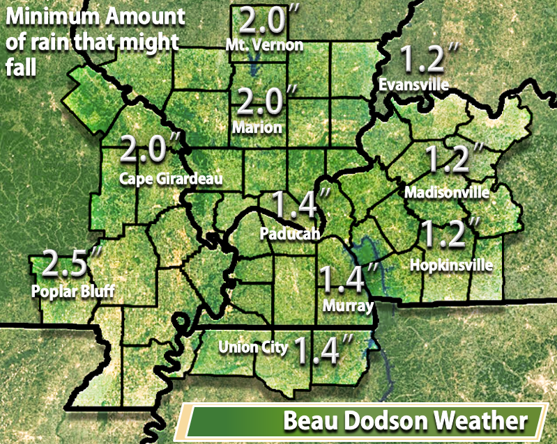
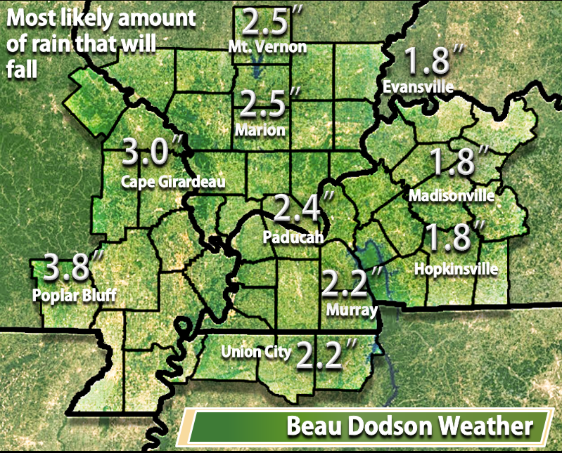
Rainfall totals with this system should be quite heavy. Expect widespread 2.20-3.20″ rainfall totals over much of southeast Missouri and southwest Illinois. Expect widespread 1.2-2.2 inches over the rest of southern Illinois, western Kentucky, and northwest Tennessee. The least amount of rain will fall over the Pennyrile area of western Kentucky. Those areas might not see a lot of rain accumulation until Tuesday night/Wednesday morning. Don’t be surprised if totals are light over our eastern counties early on in this system and then pick up late Tuesday night into Wednesday morning. The bulk of the rain, over our eastern counties, may fall when the cold front pushes through the area. Again, Tuesday night/Wednesday morning. Eastern counties means from Evansville south towards Hopkinsville, Kentucky. Although a county west of there perhaps, as well.
As far as heavier totals are concerned and flooding:
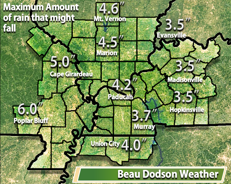
Data indicates the potential for pockets of 3-5″ of rain over the Poplar Bluff, Missouri area into the Farmington, Missouri area. This is where the heaviest rain is forecast to fall.
With that said, data does indicate heavier totals are at least possible over much of southern Illinois, far western Kentucky, and northwest Tennessee. We could see some totals over 3″ in those areas, as well.
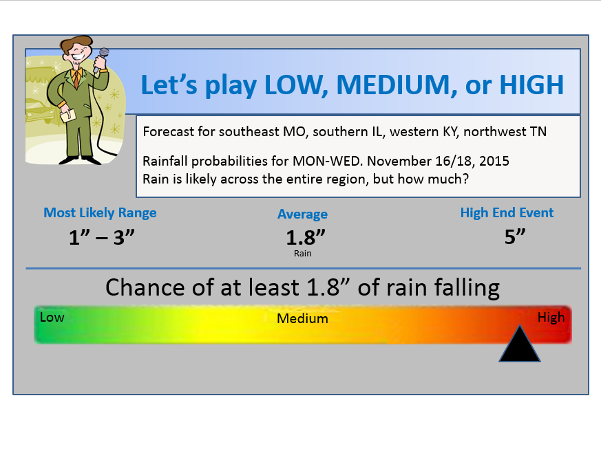
The most likely range, however, will be 1-3″ for southern Illinois and western Kentucky (least amounts expected over our eastern counties Evansville to Hopkinsville). Some unlucky soul could end up with a months worth of rain from this system. Certainly possible. Especially over our western counties in southeast Missouri and southwest Illinois. Say along a line from Poplar Bluff towards Perryville, Missouri and then towards Mt Vernon, Illinois.
A lot of this rain will fall over a two to two and a half day period of time. I have concerns, however, that a lot of this rain (perhaps more than half of it) will fall right along the cold front. If that happens then some flood warnings might need to be issued. Especially true over southeast Missouri and southwest Illinois. Something to keep an eye on as we move forward.
Some of the models show 1-2″+ falling with the passage of the cold front.
Let’s look at some maps
This is my best shot, at this point, on totals.
The first map would be the minimum amount that is expected to fall.
The second map is what should fall (I took a little bit of a conservative approach. It is certainly possible that if the front does produce a quick 1.0-2.0″ of rain then my totals will be low)
The last image is the maximum amount expected.
Let’s look at the Future-cast radar from weatherbell.com
This is the NAM model guidance
Don’t become overly excited about the bright red colors. This color scale is a little color happy. The yellow and red might mean heavier downpours, but they dot not mean severe weather.
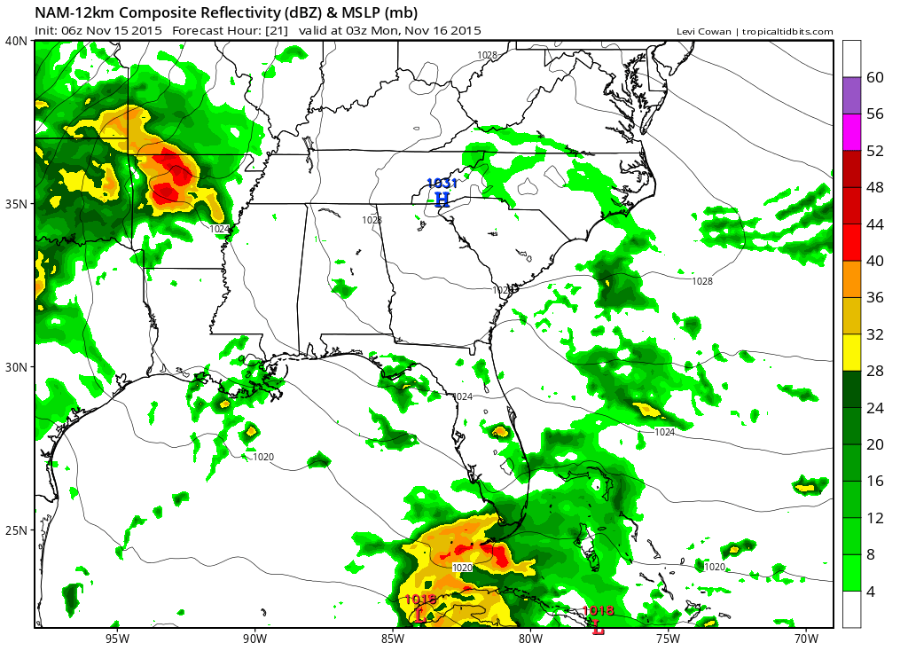
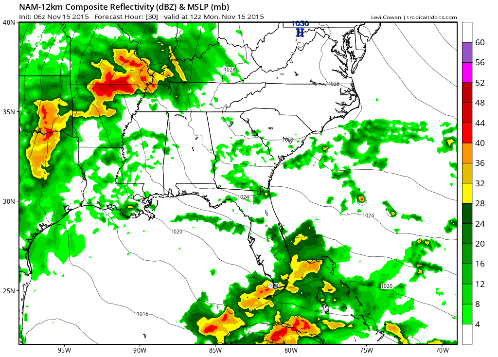
This first image is for Sunday night around 9 pm. Some rain moving into our far southwestern counties. According to this model, at least.
Moving forward in time to 6 am on Monday morning. According to the NAM model guidance we should have rain spreading fairly far east in our area. We will see how this goes. Some question as to how far east the rain will spread. But, plan on some showers for your Monday morning hours.
By Monday afternoon the rain continues. Perhaps some moderate downpours, as well. Lot of moisture spreading northward with this system.
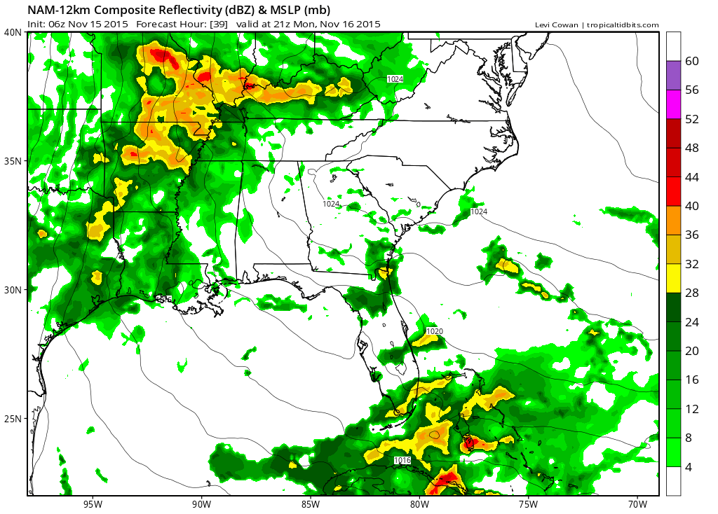
By Monday night and Tuesday morning (this is around 3 am on Tuesday morning) you can see a lot of rain in our region.
I do expect some moderate to heavy rain on Monday night/Tuesday morning. Can’t rule out some ponding of water issues on roadways and maybe even some ditches full of water.
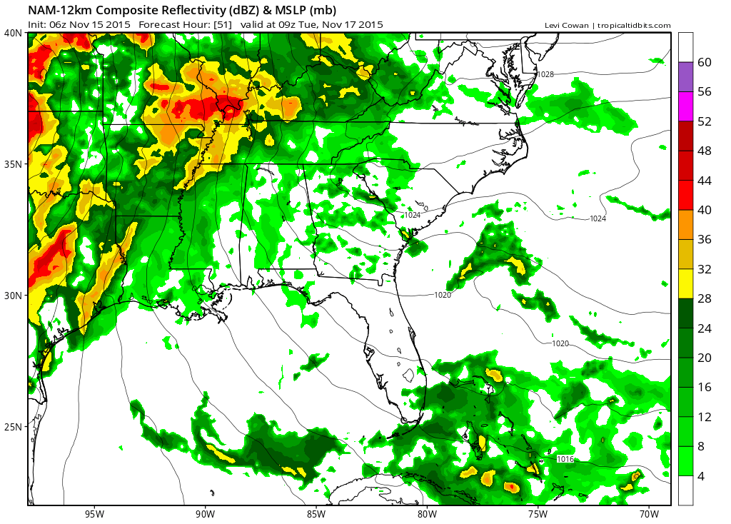
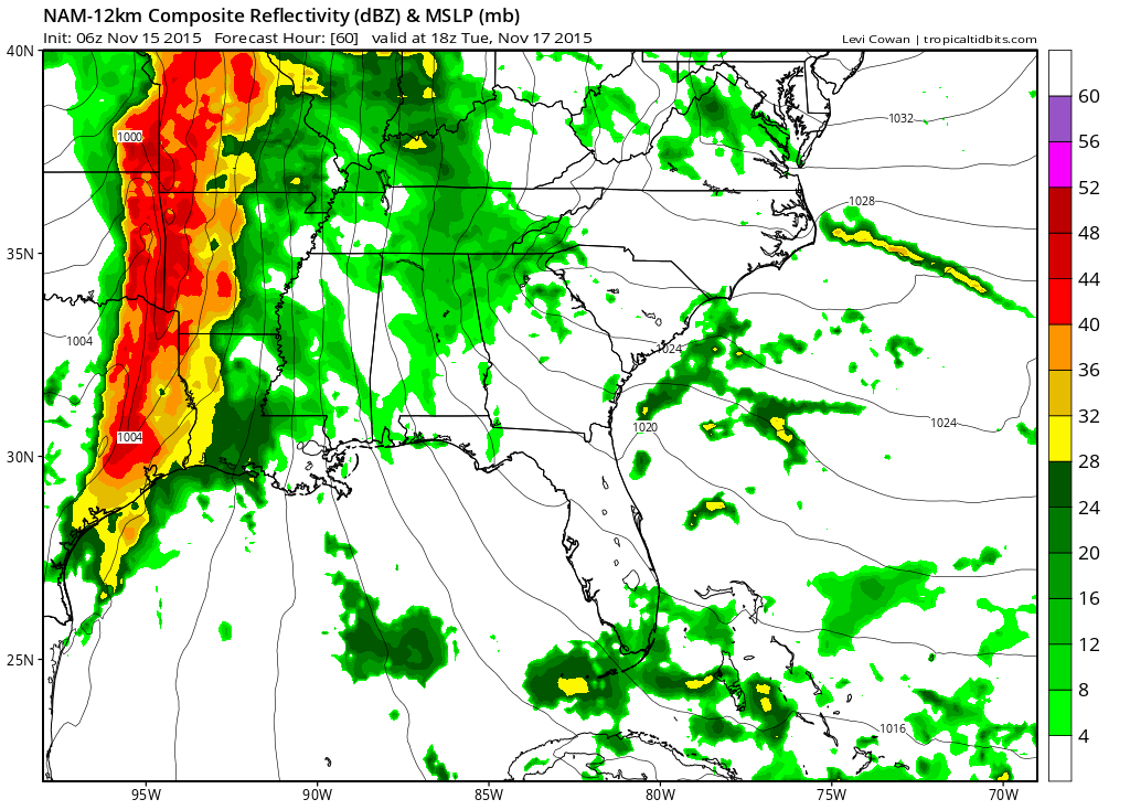
By 9 am on Tuesday morning you can see the heavier rain perhaps pulling off to our north. Watch that big heavy band of rain over western Missouri.
That, my friends, is the cold front. Forcing along the front will be strong. Lot of lift and a lot of moisture to work with. I expect the heaviest rains of this system to fall right along the cold front. The front will shift into our region Tuesday night and Wednesday morning.
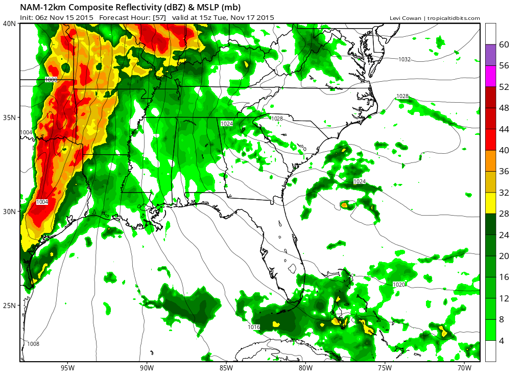
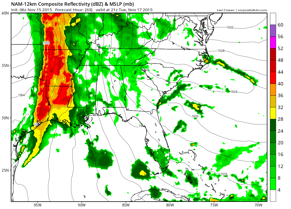
This next image is for Tuesday afternoon around 12 pm. See the front shifting east? The brighter colors are moving east. That is the cold front with heavy rain.
This next image is for 3 pm on Tuesday afternoon. Again, the front continues to slowly move eastward.
This next future-cast radar image is for Tuesday night at 9 pm. The heavy rain is now moving eastward into our western counties of southeast Missouri. Very heavy downpours are likely along the front. More than half of this systems rain may fall along the front.
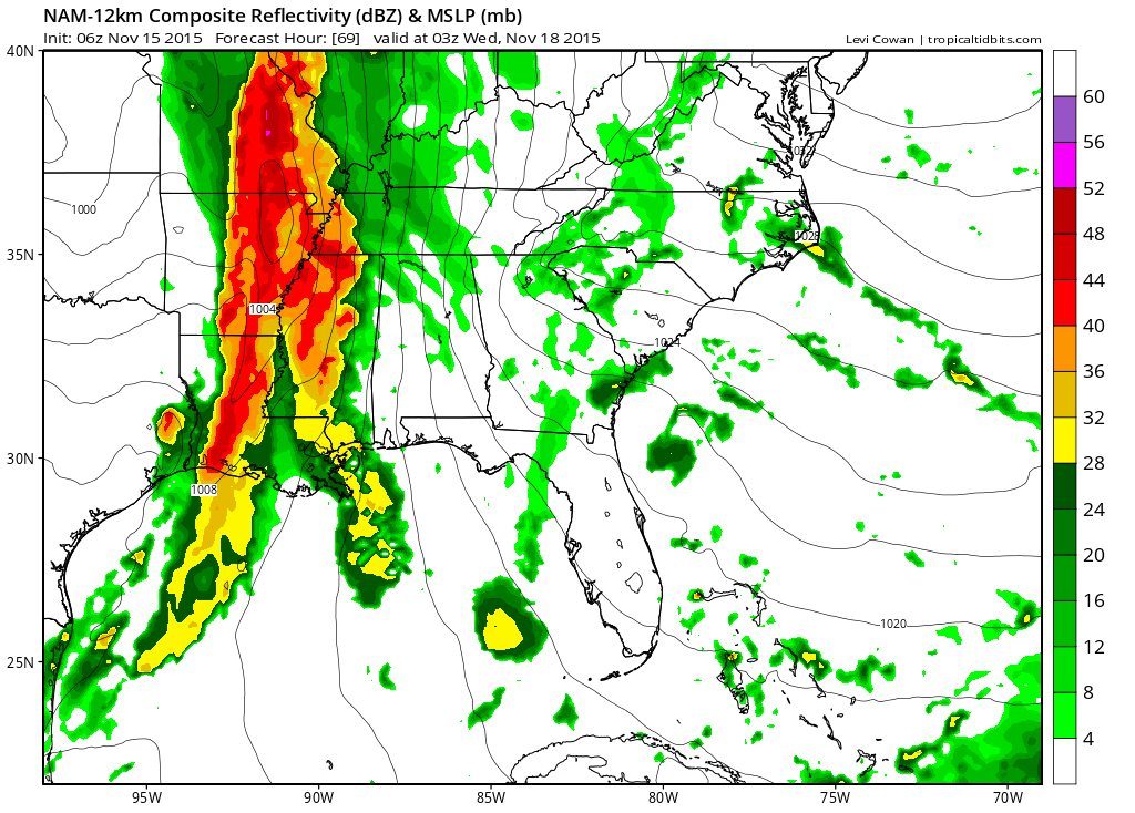
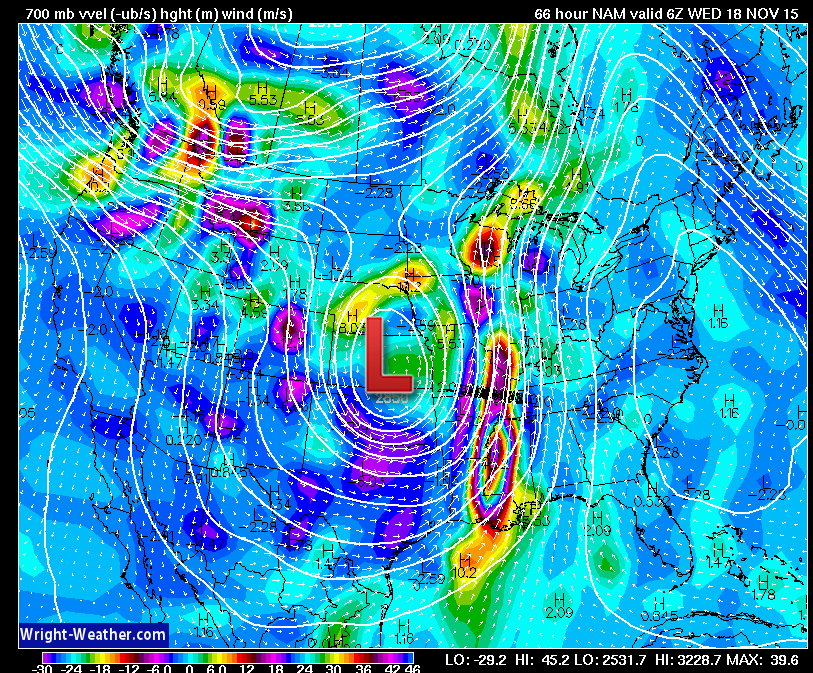
This next radar image is for Tuesday night/Wednesday morning 11 pm to 12 am. Heavy rain over our local area. I can’t completely rule out some flood warnings during this time frame. Not sure about flash flood warnings. That will depend on how much rain falls in a 2-3 hour period of time. It could be quite heavy. Keep that in mind.
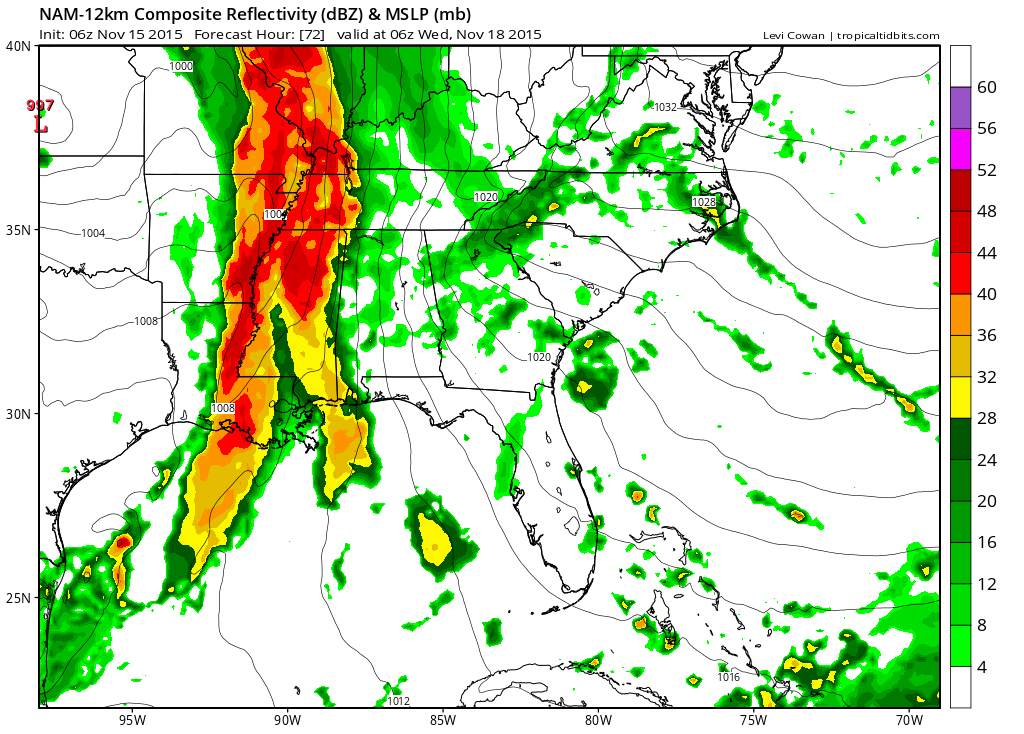
By 6 am on Wednesday morning the front is still over our region. Now, there are some disagreements on how fast the front pushes eastward. Some of the data has the front east of us by 6 am on Wednesday morning. Other data keeps it over us until late morning. Keep that in mind, as well.
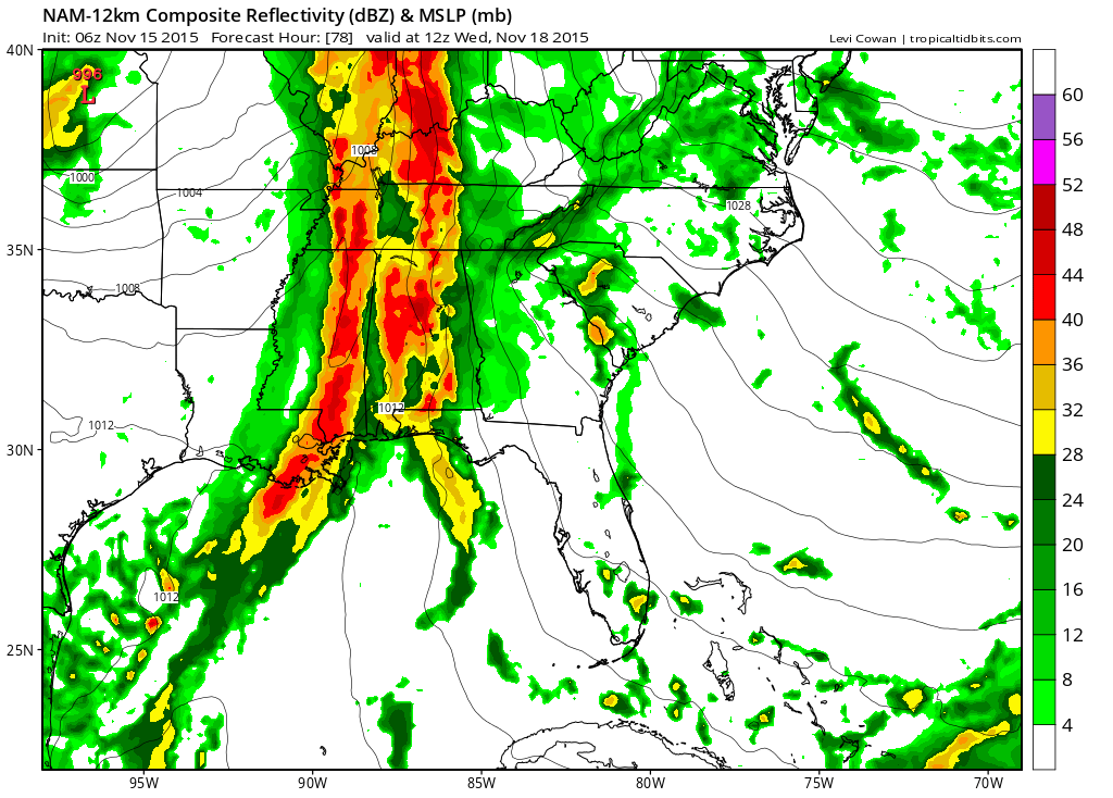
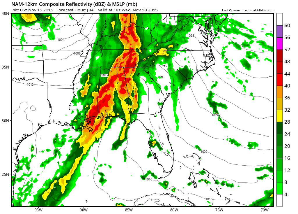
This next image is for the 9 am hour on Wednesday morning. You can see the front has pushed east. Heavier rain ends. Light rain continues (perhaps)
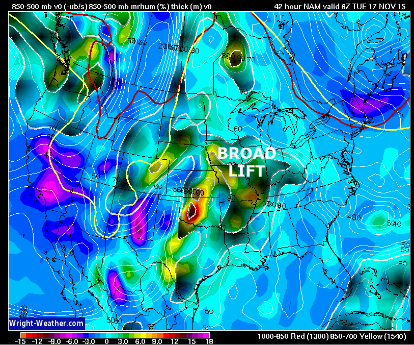
Let me show you the lift with the cold front.
This first image is for Tuesday morning around 3 am. You can see the shaded area over our region. That is a broad area of lift. The air is rising. The bright yellow colors represent the intensity of that lift and humidity levels. Some moderate to heavy downpours are possible on Monday night/Tuesday morning. But, look at the difference in the image below it.
Images are from wright-weather.com and you can click them for a larger view.
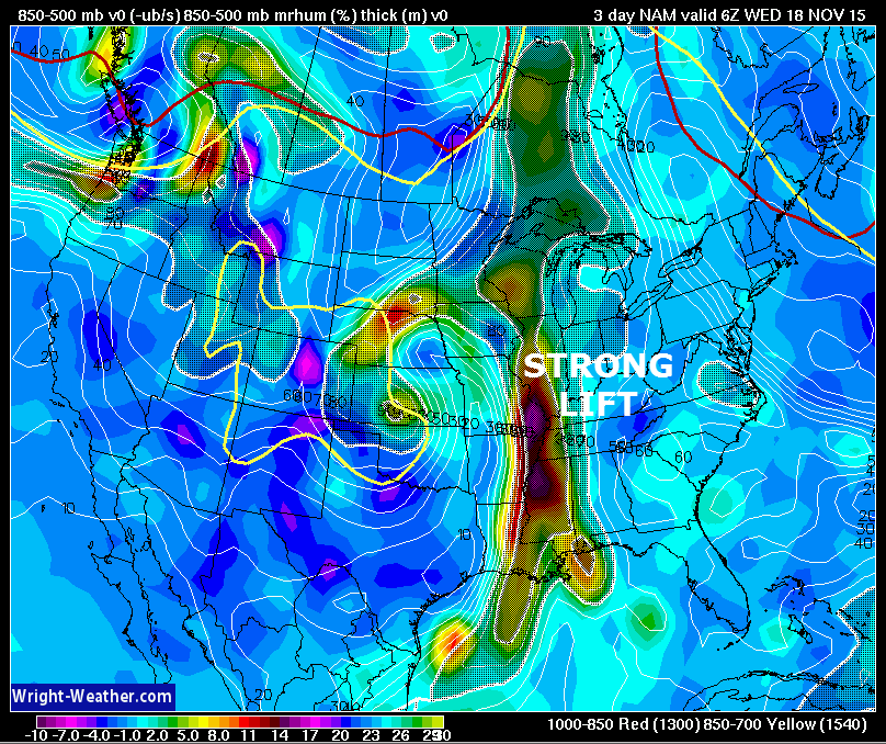
This next image shows you the strong lift right along the cold front for Tuesday night. This is when the heaviest rain will likely fall over our area.
The bright red colors represent a lot of forcing with the front.
I will show you another map.
This is the 700 mb vvel. Vertical velocities. We can find vorts on this map. Areas of lift. The bright yellow/red on Tuesday morning is one of those areas of energy/lift. That will be responsible for one round of moderate to heavy rain.
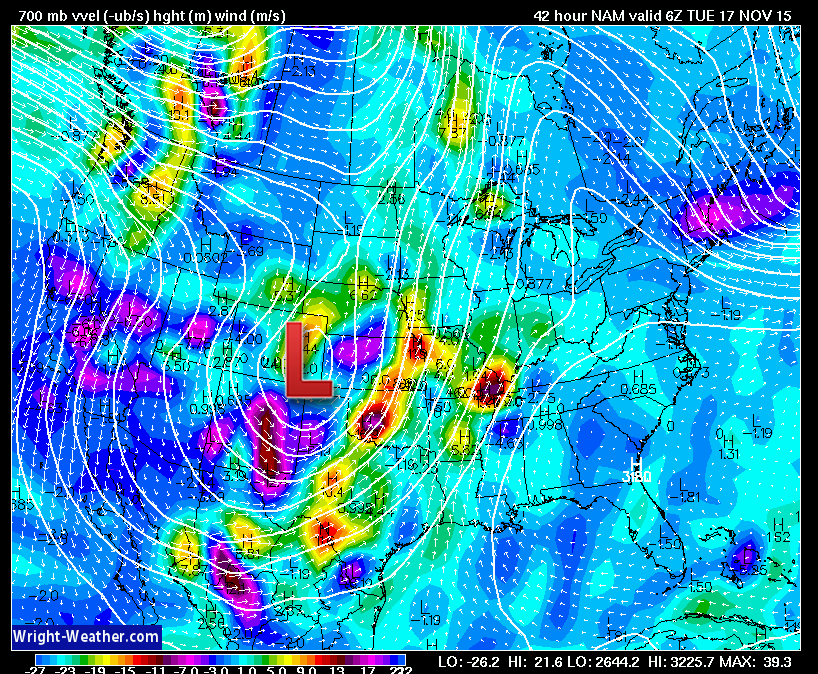
Then on Tuesday, during the day, notice how the bright colors are well west of our local area. Perhaps a lull in precipitation on Tuesday during the late morning and afternoon hours? It does seem possible. Let’s monitor that aspect of the system.
But, look to our west. See the bright colors along the front? Strong lift along that front.
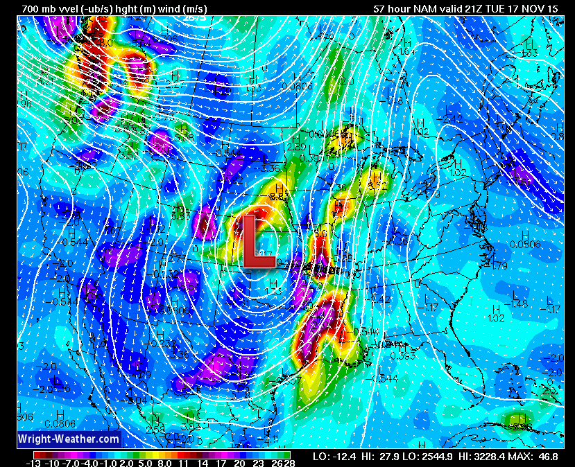
Then, here comes the front on Tuesday night. Obvious where the front is!
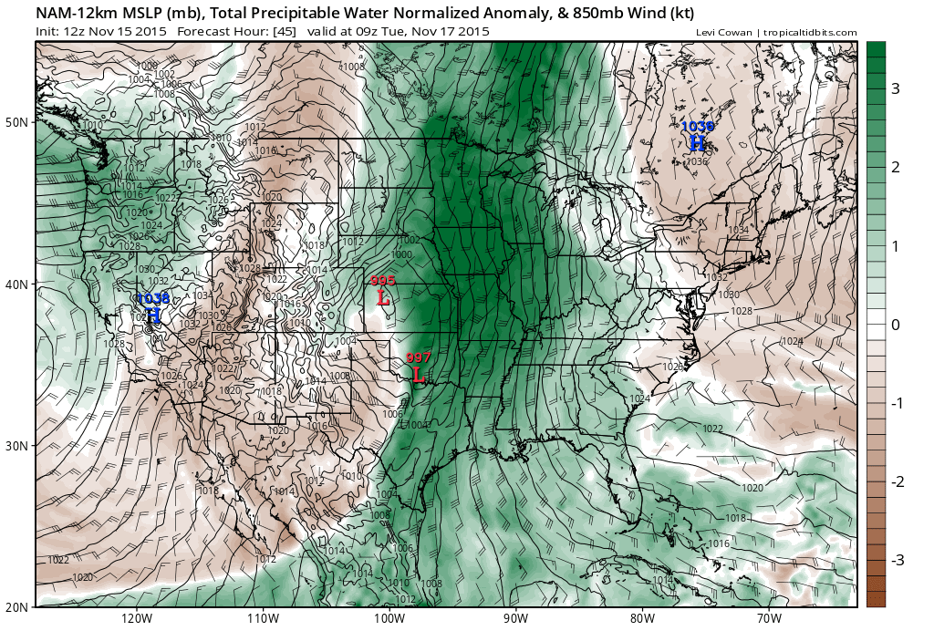
Let’s look at PWAT values. How much moisture in the atmosphere. There are the normalized anomaly maps from weatherbell.com
Click them for a larger view
PWAT values will be 2-3 standard deviations above normal at times. That is quite amazing. You math wizards will know that that equals WELL above normal PWAT values.
All of that green is a tremendous amount of moisture being pulled out of the Gulf of Mexico. And, that stream of moisture will last for a couple of days. Thus, the reason we ae expecting a lot of rain.

I continue to fine tune the timing of the rain and any potential lulls in the rain.

Concerned about heavy rain on Monday through Wednesday. Perhaps the heaviest totals on Tuesday night and Wednesday morning. I can’t rule out some flooding. The prolonged rain event should be spread out enough to prevent significant flash flooding. However, some of the models are showing excessive rainfall amounts on Tuesday night. If training occurs (storms or heavy rain moving over the same areas repeatedly) then I can’t rule out some flood warnings.
Two periods of moderate to heavy rain
1. Monday night/Tuesday early morning
2. Tuesday night and Wednesday morning

Clean out those leaves from gutters and street drainage areas. A lot of rain is headed our way. Could cause some ponding of water on roadways.

The wild card for the coming week is an easy one to pick. How much rain will fall and where will the heaviest numbers be placed.
Expect 1-3″ over the entire region. But, some places could pick up 3-5″

No frost forecast through Thursday.

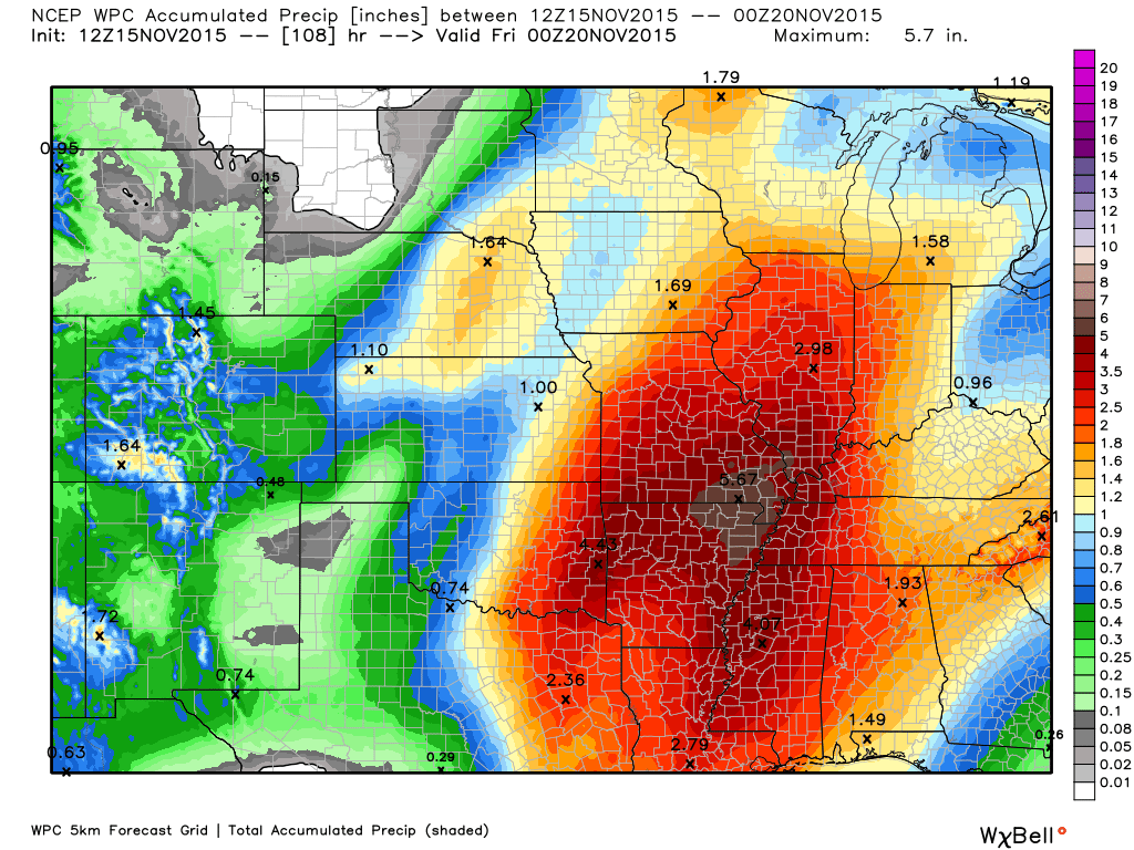
How much precipitation should we expect over the next few days?
Click map for a larger view. Graphic is from weatherbell.com
This graphic is produced by NOAA and gives you a broad-brushed look at expected totals.

Can we expect severe thunderstorms over the next 24 to 48 hours? Remember that a severe thunderstorm is defined as a thunderstorm that produces 58 mph winds or higher, quarter size hail or larger, and/or a tornado.
The thunderstorm threat level will be ZERO Monday. A rumple of thunder possible Monday night/Tuesday.
.
Monday: Severe weather is not anticipated. Thunder possible on Monday night.
Tuesday: Severe weather is not anticipated. Thunder possible.
Wednesday: Severe weather is not anticipated. Thunder possible before 8 am.
Thursday: Severe weather is not anticipated.
Friday: Severe weather is not anticipated.
Saturday: Severe weather is not anticipated.
Sunday: Severe weather is not anticipated.


We have regional radars and local city radars – if a radar does not seem to be updating then try another one. Occasional browsers need their cache cleared. You may also try restarting your browser. That usually fixes the problem. Occasionally we do have a radar go down. That is why I have duplicates. Thus, if one fails then try another one.
If you have any problems then please send me an email beaudodson@usawx.com
WEATHER RADAR PAGE – Click here —
We also have a new national interactive radar – you can view that radar by clicking here.
Local interactive city radars include St Louis, Mt Vernon, Evansville, Poplar Bluff, Cape Girardeau, Marion, Paducah, Hopkinsville, Memphis, Nashville, Dyersburg, and all of eastern Kentucky – these are interactive radars. Local city radars – click here
NOTE: Occasionally you will see ground clutter on the radar (these are false echoes). Normally they show up close to the radar sites – including Paducah.

Regional Radar – Click on radar to take you our full radar page.


Live Lightning Data – zoom and pan: Click here
Live Lightning Data with sound (click the sound button on the left side of the page): Click here

I also set up a storm tracking page with additional links (use during active weather for quick reference)
Storm Tracking Tool Page
![]()
Current WARNINGS (a warning means take action now). Click on your county to drill down to the latest warning information. Keep in mind that there can be a 2-3 minute delay in the updated warning information.
I strongly encourage you to use a NOAA Weather Radio or warning cell phone app for the most up to date warning information. Nothing is faster than a NOAA weather radio.


Color shaded counties are under some type of watch, warning, advisory, or special weather statement. Click your county to view the latest information.

Missouri Warnings

Illinois Warnings

Kentucky Warnings

Here is the official 6-10 day and 8-14 day temperature and precipitation outlook. Check the date stamp at the top of each image (so you understand the time frame).
The forecast maps below are issued by the Weather Prediction Center (NOAA).


The latest 8-14 day temperature and precipitation outlook. Note the dates are at the top of the image. These maps DO NOT tell you how high or low temperatures or precipitation will be. They simply give you the probability as to whether temperatures or precipitation will be above or below normal.


Here are the current river stage forecasts. You can click your state and then the dot for your location. It will bring up the full forecast and hydrograph.
Click Here For River Stage Forecasts…
Here are some current forecast hydrographs. These will be updated each day with new information.


Smithland Lock and Dam

Paducah, Kentucky Forecast Stage

Cairo, Illinois

Cape Girardeau, Missouri

Who do you trust for your weather information and who holds them accountable?
I have studied weather in our region since the late 1970’s. I have 37 years of experience in observing our regions weather patterns. My degree is in Broadcast Meteorology from Mississippi State University and an Associate of Science (AS). I am currently working on my Bachelor’s Degree in Geoscience.
My resume includes:
Member of the American Meteorological Society.
NOAA Weather-Ready Nation Ambassador.
Meteorologist for McCracken County Emergency Management.
I own and operate the Southern Illinois Weather Observatory.
Recipient of the Mark Trail Award, WPSD Six Who Make A Difference Award, Kentucky Colonel, and the Caesar J. Fiamma” Award from the American Red Cross.
In 2009 I was presented with the Kentucky Office of Highway Safety Award.
Recognized by the Kentucky House of Representatives for my service to the State of Kentucky leading up to several winter storms and severe weather outbreaks.
I am also President of the Shadow Angel Foundation which serves portions of western Kentucky and southern Illinois.
There is a lot of noise on the internet. A lot of weather maps are posted without explanation. Over time you should learn who to trust for your weather information.
My forecast philosophy is simple and straight forward.
- Communicate in simple terms
- To be as accurate as possible within a reasonable time frame before an event
- Interact with you on Twitter, Facebook, and the blog
- Minimize the “hype” that you might see on television or through other weather sources
- Push you towards utilizing wall-to-wall LOCAL TV coverage during severe weather events
I am a recipient of the Mark Trail Award, WPSD Six Who Make A Difference Award, Kentucky Colonel, and the Caesar J. Fiamma” Award from the American Red Cross. In 2009 I was presented with the Kentucky Office of Highway Safety Award. I was recognized by the Kentucky House of Representatives for my service to the State of Kentucky leading up to several winter storms and severe weather outbreaks.
If you click on the image below you can read the Kentucky House of Representatives Resolution.

Many of my graphics are from www.weatherbell.com – a great resource for weather data, model data, and more


You can sign up for my AWARE email by clicking here I typically send out AWARE emails before severe weather, winter storms, or other active weather situations. I do not email watches or warnings. The emails are a basic “heads up” concerning incoming weather conditions.