We have some great sponsors for the Weather Talk Blog. Please let our sponsors know that you appreciate their support for the Weather Talk Blog.
Milner and Orr Funeral Home and Cremation Services located in Paducah, Kentucky and three other western Kentucky towns – at Milner and Orr they believe in families helping families. You can find Milner and Orr on Facebook, as well.
![]()

.

Wortham Dental Care located in Paducah, Kentucky. The gentle dentist. Mercury free dentistry. They also do safe Mercury removal. You can find Wortham Dental Care on Facebook, as well
.

For all of your families eye care needs. Visit their web-site here. Or, you can also visit their Facebook page.
.

Endrizzi’s Storm Shelters – For more information click here. Endrizzi Contracting and Landscaping can be found on Facebook, as well – click here
.

Best at Enabling Body Shop Profitability since 1996. Located In Paducah Kentucky and Evansville Indiana; serving all customers in between. They provide Customer Service, along with all the tools necessary for body shops to remain educated and competitive. Click the logo above for their main web-site. You can find McClintock Preferred Finishes on Facebook, as well
.

Duck/goose decoys? Game calls? Optics? We have you covered! Click the logo above or visit Final Flight on Facebook, as well.

This forecast update covers far southern Illinois, far southeast Missouri, and far western Kentucky. See the coverage map on the right side of the blog.
Remember that weather evolves. Check back frequently for updates, especially during active weather.
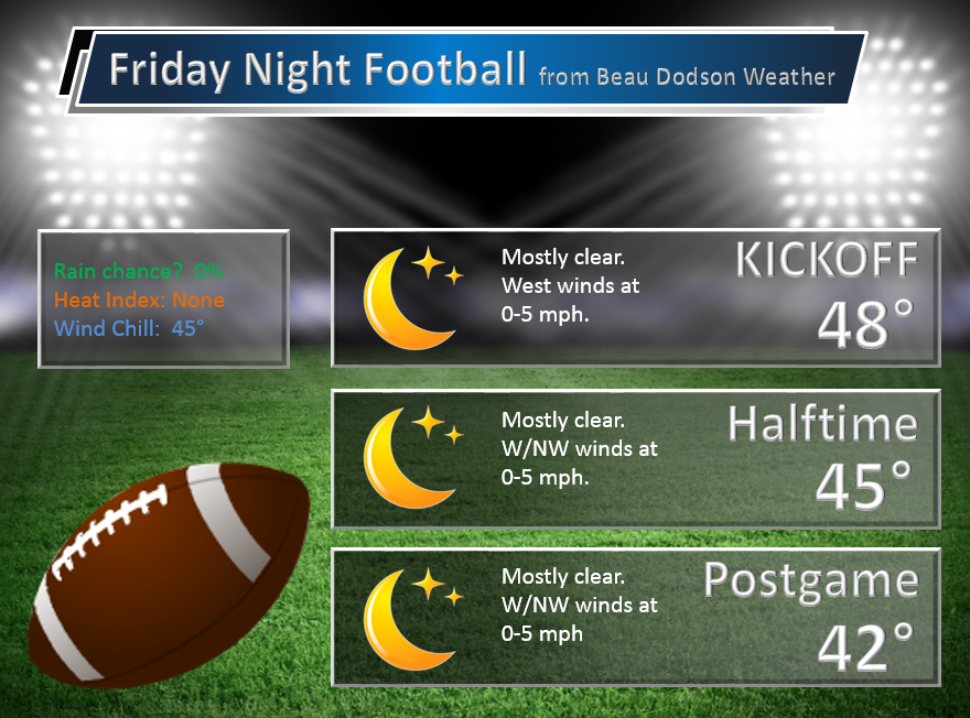
Friday night – Clear and cold. Freeze possible.
Temperatures: Lows in the middle 20s to lower 30s. Occasionally temperatures can fall a few degrees more than anticipated on nights like this.
Winds: Northwest winds at 0-5 mph
What is the chance for precipitation? 0%
Coverage of precipitation? None
My confidence in this part of the forecast verifying is High
Should I cancel my outdoor plans? No
Is severe weather expected? No
What impact is expected? A freeze is possible/likely.
Saturday – Mostly sunny.
Temperatures: Highs in the upper 50s to lower 60s
Winds: Northwest winds at 5 mph. Winds becoming west/southwest at 5 mph.
What is the chance for precipitation? 0%
Coverage of precipitation? None
My confidence in this part of the forecast verifying is High
Should I cancel my outdoor plans? No
Is severe weather expected? No
What impact is expected? None
Saturday night – Clear and cold. Frost possible.
Temperatures: Lows in the lower to middle 30s.
Winds: South winds at 0-5 mph
What is the chance for precipitation? 0%
Coverage of precipitation? None
My confidence in this part of the forecast verifying is High
Should I cancel my outdoor plans? No
Is severe weather expected? No
What impact is expected? Frost possible
Sunday – Partly sunny. Some increase in clouds late in the day.
Temperatures: Highs in the upper 50s to lower 60s.
Winds: South/southeast winds at 4-8 mph.
What is the chance for precipitation? 0%
Coverage of precipitation? None
My confidence in this part of the forecast verifying is High
Should I cancel my outdoor plans? No
Is severe weather expected? No
What impact is expected? None
Sunday night – Becoming cloudy. A chance for a shower late at night.
Temperatures: Lows in the upper 30s to lower 40s
Winds: South winds at 5 mph
What is the chance for precipitation? 20%
Coverage of precipitation? Scattered, perhaps
My confidence in this part of the forecast verifying is medium
Should I cancel my outdoor plans? No
Is severe weather expected? No
What impact is expected? Maybe some wet roadways
Monday – Cloudy. Rain showers possible.
Temperatures: Highs in the upper 50s to lower 60s.
Winds: South winds at 5-10 mph. Gusts to 15 mph
What is the chance for precipitation? 40%-60% (subject to changes)
Coverage of precipitation? Scattered to perhaps widespread at times
My confidence in this part of the forecast verifying is Medium
Should I cancel my outdoor plans? Rain is possible
Is severe weather expected? No
What impact is expected? Wet roadways
Monday night – Cloudy. Rain likely.
Temperatures: Lows in the middle to upper 40s.
Winds: South winds at 5-10 mph
What is the chance for precipitation? 60%
Coverage of precipitation? Widespread
My confidence in this part of the forecast verifying is medium
Should I cancel my outdoor plans? Perhaps. Monitor updates.
Is severe weather expected? No
What impact is expected? Wet roadways
Tuesday – Cloudy. Rain showers possible. Thunder possible. Heavy rain possible.
Temperatures: Highs in the 64 to 68 degree range.
Winds: South/southwest winds at 5-10 mph. Gusts 15-20 mph
What is the chance for precipitation? 60%
Coverage of precipitation? Scattered to widespread
My confidence in this part of the forecast verifying is Medium
Should I cancel my outdoor plans? Rain is a possibility.
Is severe weather expected? No
What impact is expected? Wet roadways. Monitor for heavy rain.
Tuesday night – Cloudy. Showers likely. Thunder possible. Heavy rain possible.
Temperatures: Lows in the middle to upper 50s.
Winds: South and southeast winds at 8-16 mph. Gusty at times.
What is the chance for precipitation? 60%
Coverage of precipitation? Scattered to widespread
My confidence in this part of the forecast verifying is medium
Should I cancel my outdoor plans? Rain is a good possibility.
Is severe weather expected? No
What impact is expected? Wet roadway. Monitor for heavy rain.
Wednesday – Cloudy. Rain showers likely. Thunder possible. Heavy rain possible.
Temperatures: Highs in the lower 60s.
Winds: South/southwest winds at 8-16 mph.
What is the chance for precipitation? 60%
Coverage of precipitation? Scattered to widespread
My confidence in this part of the forecast verifying is Medium
Should I cancel my outdoor plans? Rain is a possibility.
Is severe weather expected? No
What impact is expected? Wet roadways. Monitor for heavy rain concerns.
Click their ad below to visit their web-site or click here reedelec.com


![]()


Don’t forget to check out the Southern Illinois Weather Observatory web-site for weather maps, tower cams, scanner feeds, radars, and much more! Click here

An explanation of what is happening in the atmosphere over the coming days…
Highlights
1. Cold Saturday morning
2. Cool weekend for the region
3. Quite a bit of rain in the forecast next week
4. Several inches of rain may fall over some of our local counties. Flooding concerns?
5. Severe weather risk right now appears small. Not much CAPE. Will monitor
Welcome to the weekend!

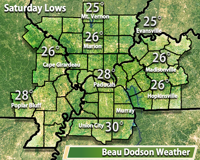
I have some cold numbers for you. Saturday morning will deliver a freeze to much of the area. Some of you have already had freeze conditions. That just means that it will be below 32 degrees for several hours. I know some of you have been asking me about this subject. Perhaps you still have some plants you are protecting. Expect temperatures to dip into the 20s by Saturday morning.
Occasionally temperatures will fall more than anticipated on clear nights with light winds. I gave the lows my best conservative shot. Some of you may end up colder than this. Don’t be surprised.
The good news is that your Friday night foot ball games will be dry. No weather concerns for football. Jacket and coat weather.
Sunday will also be dry. Expect high temperatures on both Saturday and Sunday to top out in the upper 50s to lower 60s.
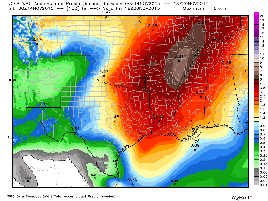
The big news is that I am expecting a lot of rain next week. I say this is big news because we need rain. And, we are about to get some.
The question is not whether it will rain. The question is how much will it rain. Models are spitting out some big numbers for the region. Some of the models are showing unbelievable numbers. I am always a bit suspect when models show extreme weather. But, this might be worth monitoring.
There will be no lack of moisture with this particular storm system as it pulls out of the west. Expect a steady stream of high PWAT values starting on Monday and lasting into Wednesday night.
Five out of the five parameters I monitor for heavy rain are showing up in the model guidance. This event is still several days away, but it is lining up to be a significant rain producer. Let’s ease into this. Ramp up and not down. The exact placement of the heavier rain is also still in question. Will it be our western counties? Central?
PWAT values are a measure of moisture in the atmosphere. Meteorologists use PWAT values to determine how much rain the atmosphere might generate. One thing I look for in PWAT values is whether or not they are long lasting in any given area. And, the models are showing high PWAT values for an extended period of time over our region next week.
What are PWAT values? Great question! I found this blog post that explains it quite well. Click here for more information on PWAT values.
Cautionary flags are going up in my head when it comes to predicting how much rain will fall. Let’s keep an eye on this.
For now I took the conservative approach of 1-2″ area wide. Some of the data paints the heavier totals over northern Arkansas into southeast Missouri. Other models are a bit further east. Either way, a widespread rain event is on tap for our region.
A few showers will be possible late Sunday night. But, more likely on Monday, Tuesday, and Wednesday. Perhaps lasting into Wednesday night. I will have to fine tune the timing of the exit.
As far as the severe weather concerns. I am already hearing chatter from different sources about tornadoes and a severe weather outbreak. Right now the CAPE values are not overly impressive for our region (none to very little). This was what happened earlier this week. No CAPE. But, quite a bit of shear. I will keep monitoring the data.
What are CAPE values and what do they mean in relation to severe weather? I found a great post about CAPE values and this should explain it. For you go-getter weather enthusiasts – click here
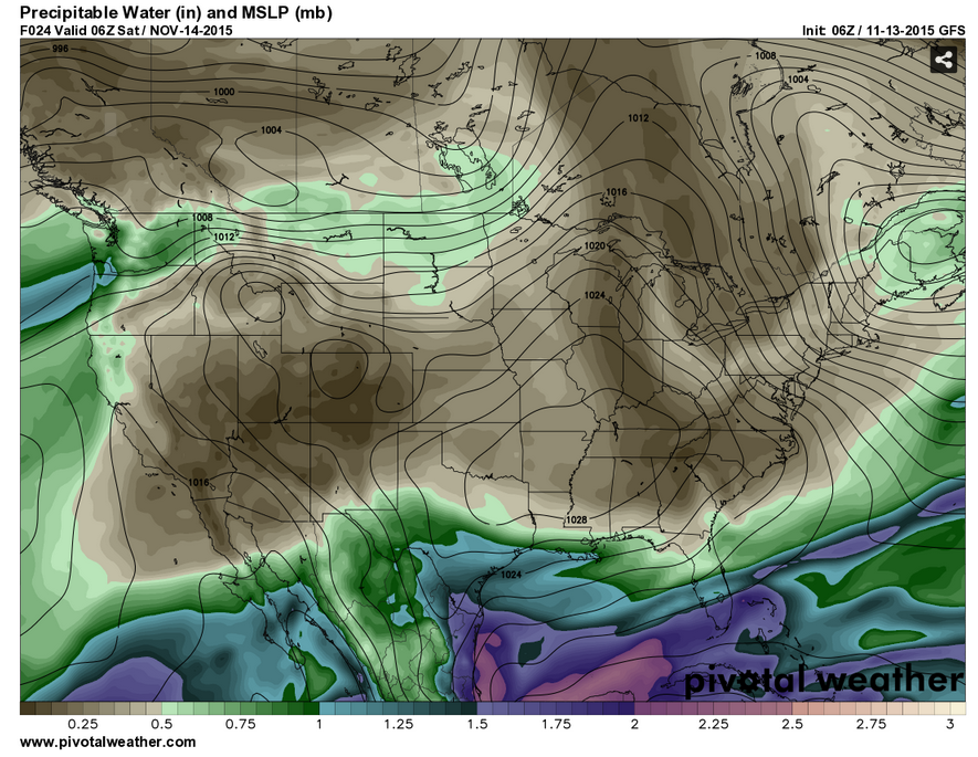
Let’s take a look at a few weather maps
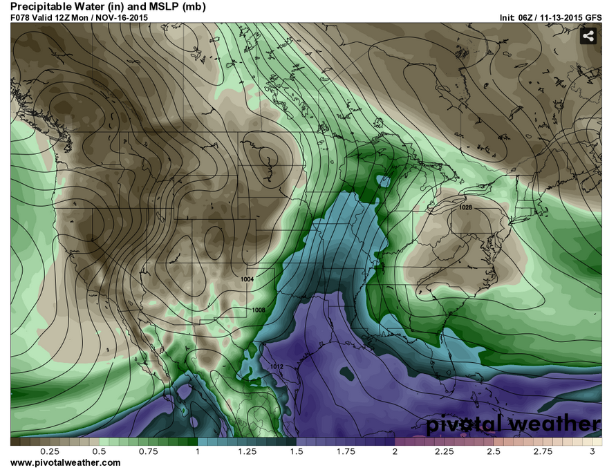
I wanted to show you the PWAT value maps. The idea to take away from these maps is how long the high numbers sit over our region.
Let’s start out with Saturday. See the brown colors over our local area? Dry air. Brown = dry air on these maps. Green and blue indicate moisture.
Where is the moisture? Well to our south. It will take an area of low pressure coming out of the southwest to help pull the moisture northward. Remember that low pressure spins counter-clockwise. Thus, a low to our west would pull moisture northward out of the Gulf of Mexico. And, that is what will happen next week.
You can click any of these maps to make them larger. Most of these maps are from Pivotalweather.com
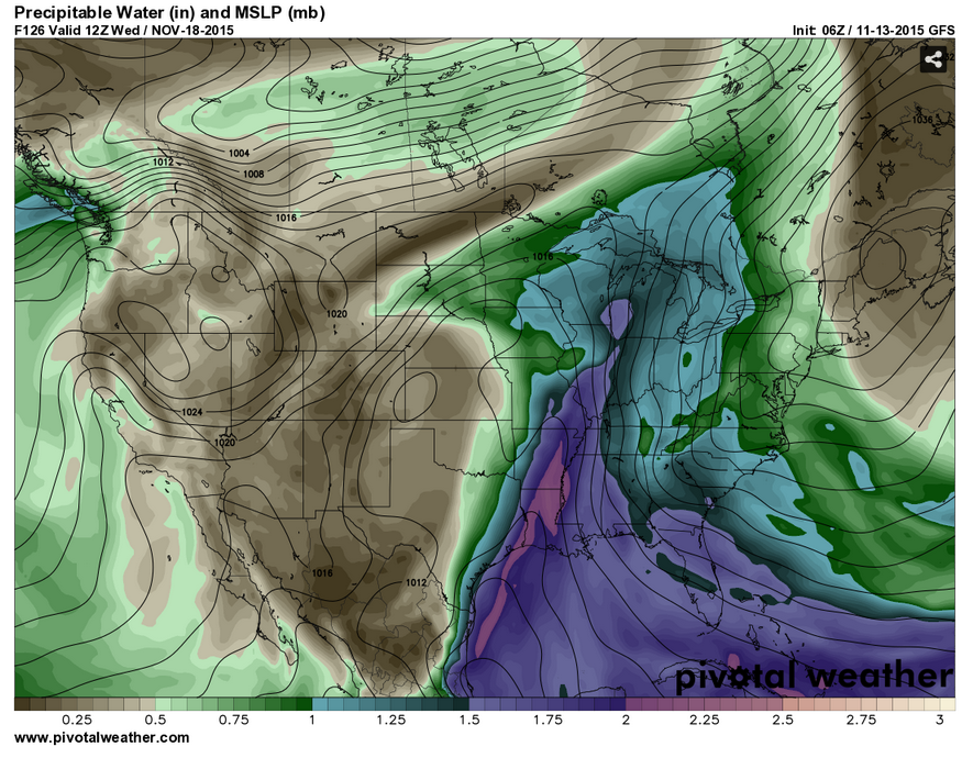
Now, let’s move forward in time. This next map is for Monday morning. Wow, what a change. Moisture rapidly pulling northward into our region. The purple colors are the deepest moisture.
This next map is for Tuesday morning. Look at all that moisture streaming northward. You can see the closed isobars (circle) over southwest Kansas. That is the area of low pressure.

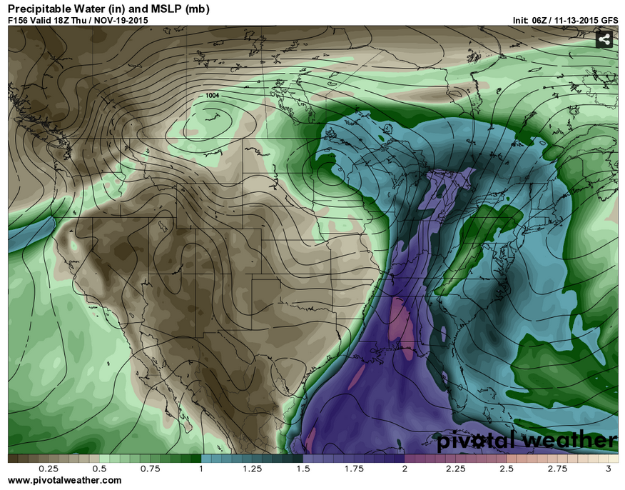
Then this next map is for Wednesday morning. Very high PWAT values in our region. Could be some heavy rain.
And, finally this last map is for Thursday. According to this model the moisture finally pulls away on Thursday. I will need to work on the timing of the exit of the rain.
Now, let me show you the CAPE map. We are still several days out. This could change. But, for now the CAPE levels look low on the model guidance. That would be good news because we would avoid severe weather. I will keep monitoring and update as we move forward.

Let me show you some upper air wind maps.
This first map is the 800 mb level. That is about 5000′ aloft. Look at the winds streaming northward from the Gulf of Mexico. The gulf is wide open. Lot of moisturre
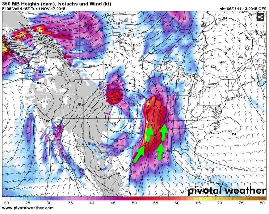
Now the 500 mb map. This is about 18,000′ aloft. You can see the jet diving south and west. Moisture streaming into our region from the southwest. You can also see how the winds have divergence over the Central United States. An indication of quite a bit of lift in the atmosphere.
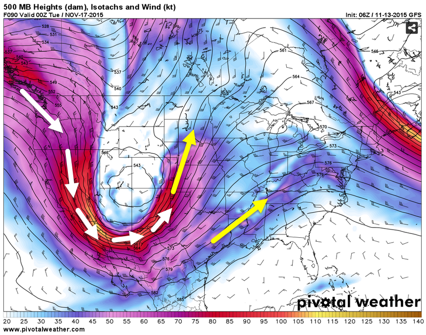
Plan on a wet week!

No major changes in this update.

No concerns on Saturday, or Sunday. A freeze (temperatures below freezing) possible on Saturday morning and frost on Sunday morning.
Monitoring the potential for some heavy rain next week. Still early in the game for numbers. But, let’s keep an eye on it.

No. Freeze possible Saturday morning and a frost on Sunday morning.

The wild card for Saturday morning will be low temperatures. How low will we go. Many locations will dip into the 20s.

Frost/Freeze possible on Saturday and Sunday morning.

How much precipitation should we expect over the next few days?
No rain is in the forecast Thursday through Sunday.
Next week we could have some decent rainfall totals.
Click map for a larger view. Graphic is from weatherbell.com
This graphic is produced by NOAA and has been changing daily. More changes likely.

Can we expect severe thunderstorms over the next 24 to 48 hours? Remember that a severe thunderstorm is defined as a thunderstorm that produces 58 mph winds or higher, quarter size hail or larger, and/or a tornado.
The thunderstorm threat level will be ZERO on Saturday-Sunday.
.
Saturday: Severe weather is not anticipated.
Sunday: Severe weather is not anticipated.
Monday: Severe weather is not anticipated.
Tuesday: Severe weather is not anticipated.
Wednesday: Severe weather is not anticipated.


We have regional radars and local city radars – if a radar does not seem to be updating then try another one. Occasional browsers need their cache cleared. You may also try restarting your browser. That usually fixes the problem. Occasionally we do have a radar go down. That is why I have duplicates. Thus, if one fails then try another one.
If you have any problems then please send me an email beaudodson@usawx.com
WEATHER RADAR PAGE – Click here —
We also have a new national interactive radar – you can view that radar by clicking here.
Local interactive city radars include St Louis, Mt Vernon, Evansville, Poplar Bluff, Cape Girardeau, Marion, Paducah, Hopkinsville, Memphis, Nashville, Dyersburg, and all of eastern Kentucky – these are interactive radars. Local city radars – click here
NOTE: Occasionally you will see ground clutter on the radar (these are false echoes). Normally they show up close to the radar sites – including Paducah.

Regional Radar – Click on radar to take you our full radar page.


Live Lightning Data – zoom and pan: Click here
Live Lightning Data with sound (click the sound button on the left side of the page): Click here

I also set up a storm tracking page with additional links (use during active weather for quick reference)
Storm Tracking Tool Page
![]()
Current WARNINGS (a warning means take action now). Click on your county to drill down to the latest warning information. Keep in mind that there can be a 2-3 minute delay in the updated warning information.
I strongly encourage you to use a NOAA Weather Radio or warning cell phone app for the most up to date warning information. Nothing is faster than a NOAA weather radio.


Color shaded counties are under some type of watch, warning, advisory, or special weather statement. Click your county to view the latest information.

Missouri Warnings

Illinois Warnings

Kentucky Warnings

Here is the official 6-10 day and 8-14 day temperature and precipitation outlook. Check the date stamp at the top of each image (so you understand the time frame).
The forecast maps below are issued by the Weather Prediction Center (NOAA).


The latest 8-14 day temperature and precipitation outlook. Note the dates are at the top of the image. These maps DO NOT tell you how high or low temperatures or precipitation will be. They simply give you the probability as to whether temperatures or precipitation will be above or below normal.


Here are the current river stage forecasts. You can click your state and then the dot for your location. It will bring up the full forecast and hydrograph.
Click Here For River Stage Forecasts…
Here are some current forecast hydrographs. These will be updated each day with new information.


Smithland Lock and Dam

Paducah, Kentucky Forecast Stage

Cairo, Illinois

Cape Girardeau, Missouri

Who do you trust for your weather information and who holds them accountable?
I have studied weather in our region since the late 1970’s. I have 37 years of experience in observing our regions weather patterns. My degree is in Broadcast Meteorology from Mississippi State University and an Associate of Science (AS). I am currently working on my Bachelor’s Degree in Geoscience.
My resume includes:
Member of the American Meteorological Society.
NOAA Weather-Ready Nation Ambassador.
Meteorologist for McCracken County Emergency Management.
I own and operate the Southern Illinois Weather Observatory.
Recipient of the Mark Trail Award, WPSD Six Who Make A Difference Award, Kentucky Colonel, and the Caesar J. Fiamma” Award from the American Red Cross.
In 2009 I was presented with the Kentucky Office of Highway Safety Award.
Recognized by the Kentucky House of Representatives for my service to the State of Kentucky leading up to several winter storms and severe weather outbreaks.
I am also President of the Shadow Angel Foundation which serves portions of western Kentucky and southern Illinois.
There is a lot of noise on the internet. A lot of weather maps are posted without explanation. Over time you should learn who to trust for your weather information.
My forecast philosophy is simple and straight forward.
- Communicate in simple terms
- To be as accurate as possible within a reasonable time frame before an event
- Interact with you on Twitter, Facebook, and the blog
- Minimize the “hype” that you might see on television or through other weather sources
- Push you towards utilizing wall-to-wall LOCAL TV coverage during severe weather events
I am a recipient of the Mark Trail Award, WPSD Six Who Make A Difference Award, Kentucky Colonel, and the Caesar J. Fiamma” Award from the American Red Cross. In 2009 I was presented with the Kentucky Office of Highway Safety Award. I was recognized by the Kentucky House of Representatives for my service to the State of Kentucky leading up to several winter storms and severe weather outbreaks.
If you click on the image below you can read the Kentucky House of Representatives Resolution.

Many of my graphics are from www.weatherbell.com – a great resource for weather data, model data, and more


You can sign up for my AWARE email by clicking here I typically send out AWARE emails before severe weather, winter storms, or other active weather situations. I do not email watches or warnings. The emails are a basic “heads up” concerning incoming weather conditions.