We have some great sponsors for the Weather Talk Blog. Please let our sponsors know that you appreciate their support for the Weather Talk Blog.
Milner and Orr Funeral Home and Cremation Services located in Paducah, Kentucky and three other western Kentucky towns – at Milner and Orr they believe in families helping families. You can find Milner and Orr on Facebook, as well.
![]()
.

Wortham Dental Care located in Paducah, Kentucky. The gentle dentist. Mercury free dentistry. They also do safe Mercury removal. You can find Wortham Dental Care on Facebook, as well
.

For all of your families eye care needs. Visit their web-site here. Or, you can also visit their Facebook page.
.

Endrizzi’s Storm Shelters – For more information click here. Endrizzi Contracting and Landscaping can be found on Facebook, as well – click here
.

Best at Enabling Body Shop Profitability since 1996. Located In Paducah Kentucky and Evansville Indiana; serving all customers in between. They provide Customer Service, along with all the tools necessary for body shops to remain educated and competitive. Click the logo above for their main web-site. You can find McClintock Preferred Finishes on Facebook, as well
.

Duck/goose decoys? Game calls? Optics? We have you covered! Click the logo above or visit Final Flight on Facebook, as well.

This forecast update covers far southern Illinois, far southeast Missouri, and far western Kentucky. See the coverage map on the right side of the blog.
Remember that weather evolves. Check back frequently for updates, especially during active weather.
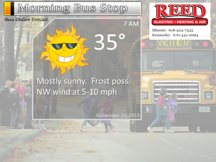
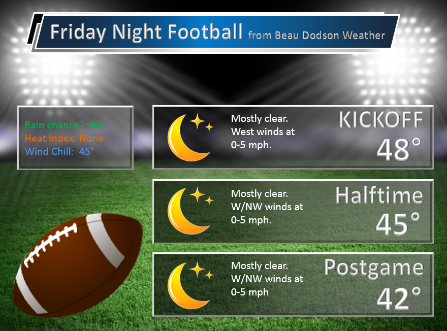
Thursday night – Clear and cool.
Temperatures: Lows in the lower to middle 30s.
Winds: West winds at 5 mph
What is the chance for precipitation? 0%
Coverage of precipitation? None
My confidence in this part of the forecast verifying is High
Should I cancel my outdoor plans? No
Is severe weather expected? No
What impact is expected? None
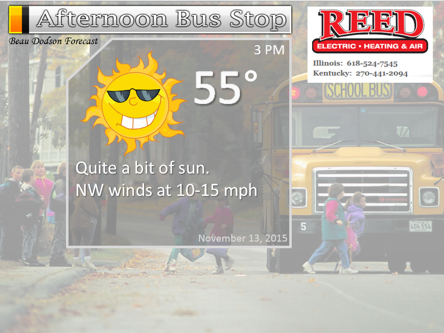
Friday – Mostly sunny.
Temperatures: Highs from 52 to 56
Winds: West winds at 5-10 mph.
What is the chance for precipitation? 0%
Coverage of precipitation? None
My confidence in this part of the forecast verifying is High
Should I cancel my outdoor plans? No
Is severe weather expected? No
What impact is expected? None
Friday night – Clear and cold. Freeze possible.
Temperatures: Lows in the upper 20s to lower 30s.
Winds: Northwest winds at 0-5 mph
What is the chance for precipitation? 0%
Coverage of precipitation? None
My confidence in this part of the forecast verifying is High
Should I cancel my outdoor plans? No
Is severe weather expected? No
What impact is expected? A freeze is possible.
Saturday – Mostly sunny.
Temperatures: Highs in the middle to upper 50s.
Winds: Northwest winds at 5-10 mph.
What is the chance for precipitation? 0%
Coverage of precipitation? None
My confidence in this part of the forecast verifying is High
Should I cancel my outdoor plans? No
Is severe weather expected? No
What impact is expected? None
Saturday night – Clear and cold. Frost possible.
Temperatures: Lows in the lower to middle 30s.
Winds: South winds at 5 mph
What is the chance for precipitation? 0%
Coverage of precipitation? None
My confidence in this part of the forecast verifying is High
Should I cancel my outdoor plans? No
Is severe weather expected? No
What impact is expected? Frost possible
Sunday – Partly sunny. Some increase in clouds late in the day.
Temperatures: Highs in the upper 50s to lower 60s.
Winds: South winds at 5-10 mph.
What is the chance for precipitation? 0%
Coverage of precipitation? None
My confidence in this part of the forecast verifying is High
Should I cancel my outdoor plans? No
Is severe weather expected? No
What impact is expected? None
Sunday night – Becoming cloudy. A chance for a shower.
Temperatures: Lows in the upper 30s to lower 40s
Winds: South winds at 5 mph
What is the chance for precipitation? 20%
Coverage of precipitation? Scattered, perhaps
My confidence in this part of the forecast verifying is medium
Should I cancel my outdoor plans? No
Is severe weather expected? No
What impact is expected? Maybe some wet roadways
Monday – Cloudy. Rain showers possible.
Temperatures: Highs in the upper 50s to lower 60s.
Winds: South winds at 5-10 mph. Gusts to 15 mph
What is the chance for precipitation? 40% (subject to changes)
Coverage of precipitation? Scattered
My confidence in this part of the forecast verifying is Medium
Should I cancel my outdoor plans? Monitor updates.
Is severe weather expected? No
What impact is expected? Wet roadways
Monday night – Cloudy. Rain likely.
Temperatures: Lows in the middle to upper 40s.
Winds: South winds at 5-10 mph
What is the chance for precipitation? 60%
Coverage of precipitation? Widespread
My confidence in this part of the forecast verifying is medium
Should I cancel my outdoor plans? Perhaps. Monitor updates.
Is severe weather expected? No
What impact is expected? Wet roadways
Tuesday – Cloudy. Rain showers possible. Thunder possible.
Temperatures: Highs in the lower 60s.
Winds: South/southwest winds at 5-10 mph. Gusts 15 mph
What is the chance for precipitation? 40% (perhaps higher). Still some time to monitor this.
Coverage of precipitation? Scattered
My confidence in this part of the forecast verifying is Medium
Should I cancel my outdoor plans? Monitor updates. Rain is a possibility.
Is severe weather expected? No
What impact is expected? Wet roadways
Tuesday night – Cloudy. Showers possible.
Temperatures: Lows in the middle to upper 40s.
Winds: South winds at 5-10 mph
What is the chance for precipitation? 40%-60%
Coverage of precipitation? Scattered
My confidence in this part of the forecast verifying is medium
Should I cancel my outdoor plans? Perhaps. Monitor updates.
Is severe weather expected? No
What impact is expected? Wet roadway
Wednesday – Cloudy. Rain showers possible.
Temperatures: Highs in the lower 60s.
Winds: South/southwest winds at 5-10 mph.
What is the chance for precipitation? 40% (perhaps higher). Still some time to monitor this.
Coverage of precipitation? Scattered
My confidence in this part of the forecast verifying is Medium
Should I cancel my outdoor plans? Monitor updates. Rain is a possibility.
Is severe weather expected? No
What impact is expected? Wet roadways
Click their ad below to visit their web-site or click here reedelec.com


![]()


Don’t forget to check out the Southern Illinois Weather Observatory web-site for weather maps, tower cams, scanner feeds, radars, and much more! Click here

An explanation of what is happening in the atmosphere over the coming days…
Highlights
1. Calm weather through Sunday
2. Some frost possible Friday morning through Sunday morning
3. Rain returns early next week. But, how much rain?
Well, we have some nice calm fall weather ahead of us. At least for a few days. But, I am already tracking our next rain maker.
Expect nice weather through Sunday afternoon. Perhaps a few patchy clouds from time to time. But, nothing extreme and nothing dramatic. Just the way we like our weather forecast.
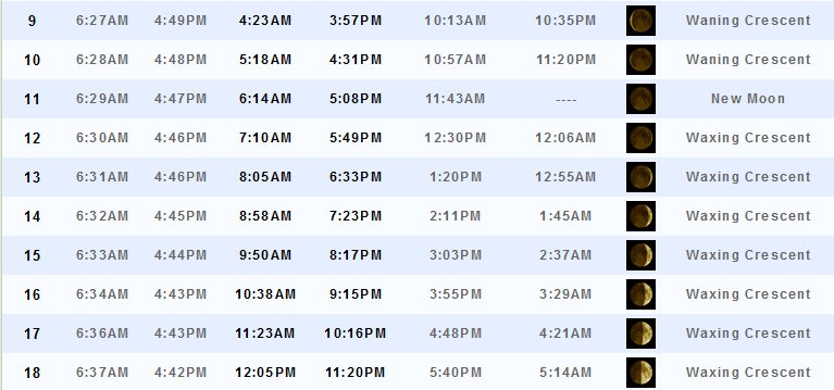
We will have some cool mornings. Expect 30s for Friday morning, Saturday morning, and Sunday morning. Frost will be possible and even a freeze in some counties. Most of us have already had a frost. Some have not had a freeze.
Our next weather maker is a complicated one. When aren’t they? A system will pull out of the southwest United States starting on Sunday night and Monday. It will slowly make its way eastward and northeastward into the early part of the week.
The current thinking is that we should see quite a bit of moisture returning northward ahead of this system. And, that could spell widespread rain chances for the region. Some of the data is painting rainfall totals of 1-2″. Locally heavier. Still a bit early to bank on numbers. The take away from this is that we can expect rain to develop as early as Sunday night and continue into Tuesday/Wednesday. And, perhaps a soaking rain.
Let’s keep an eye on it.
A couple of maps for this next rain maker. This is the GFS and it is a bit stronger with the surface low than some other model guidance.
This first map is for Monday morning. You can see some showers in or near our region. Timing of this will need to be adjusted as we move forward. Green color represents rain. Blue is snow.
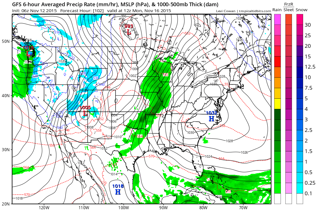
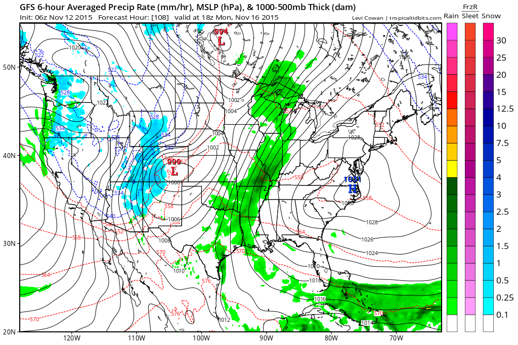
Moving ahead to Monday around 12 pm. Rain over our region appears to be a good possibility.
And, finally this last map is for Tuesday morning. Still some rain in our region.
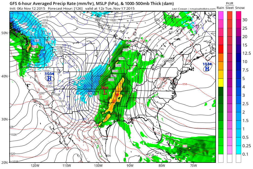
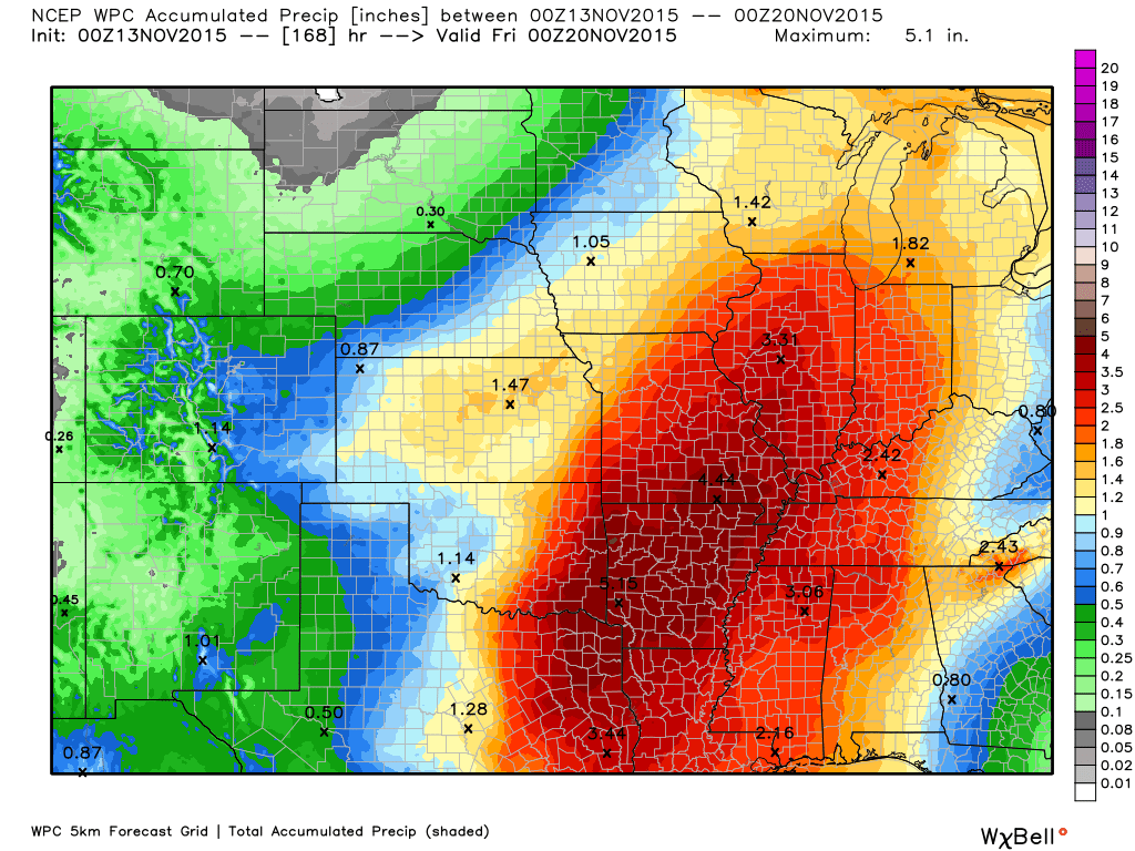
Rainfall totals next week could be on the heavy side. Here is the official forecast from NOAA. Still time for adjustments.
Let’s talk about Wednesday’s weather event (November 11, 2015).
As we move into the winter months you are going to see a lot of day 3, 4, 5, infinity and beyond snowfall forecast maps. Don’t believe them. And, don’t share them. It only spreads rumors and false information. It also makes my job a lot harder.
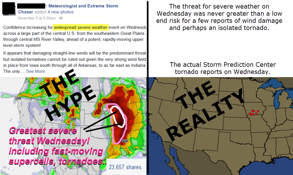
The same goes for severe weather. Leading up to yesterdays potential event there was a lot of hype. I don’t know know how many people asked me about this map I am going to post below. And, I am glad they asked. It gave me a chance to explain the difference between a realistic forecast and a hyped up dramatic “hey click here and share my post” forecast.
Unfortunately, the calmer and more realistic forecasts are not shared nearly as much as the scary and dramatic ones. Must be human nature? I don’t know.
Perfect example in this image below. A well known chaser posted this map a couple of days in advance of Wednesdays weather maker. Sadly, he is a great forecaster and should know better. But, this is common practice on his site. It was shared over 23,000 times from his page alone. No telling how many re-shares. Likely over 100,000.
The map on the right shows you the verification of his forecast. Almost his entire zone of fear was left with no verified tornadoes. And, for that matter no reports of severe weather at all in our region.
And, this is why I tell you to trust some of our local forecasters (I say some because we have some issues locally, as well). The ones who don’t scare you 2, 3, 4, and 5+ days in advance.
We have a lot of great forecasters in our region. The WSIL weather team has the same philosophy. Slow and easy. Ramp up and not down.
We will be seeing a lot of snowfall maps being shared over the coming months. Days in advance. A skilled meteorologist will not give you snowfall totals until about 24 hours in advance. Yes, there may be some discussion on the potential of a system, but a real forecast with real snowfall numbers is rarely reliable more than 12-24 hours in advance. And, sometimes those forecasts don’t even completely verify.
This is especially true of the bigger systems.
The same applies to severe weather. If you start seeing scary severe weather maps days in advance then that is a red flag. Yes, there will be some rare occasions when forecasters can agree on the potential of a system several days out, but that is not the norm. And, the event on Wednesday was certainly not one of them. The risk on Wednesday was never all that great. Low CAPE (to know CAPE) and a high shear environment.
Slow and easy wins the forecast race. Ramp up and not down. That is my forecast philosophy. You ease into a forecast. You don’t go hog wild days in advance only to have to back way day the day of the event.
My forecasts won’t always be correct, but I will do my best to give you a reasonable assessment of the potential. Without scaring you. And, without adding undo anxiety into your daily life.
I will be available the day of events with posts that will answer your questions, give you the latest information, and track the storms if they develop. You will always know if the threat is low end, medium, or high. With thorough discussions leading up to the event.
This graphic completely sums it up what I will continue to preach.

No major changes in this update.

No concerns on Friday, Saturday, or Sunday. Some frost possible. Rest for the weatherman.

No. Other than some frost possible this weekend.

Calm weather for a few days. No wild card in this forecast!

Frost/Freeze possible on Friday, Saturday, and Sunday morning

How much precipitation should we expect over the next few days?
No rain is in the forecast Thursday through Sunday.
Next week we could have some decent rainfall totals.

Can we expect severe thunderstorms over the next 24 to 48 hours? Remember that a severe thunderstorm is defined as a thunderstorm that produces 58 mph winds or higher, quarter size hail or larger, and/or a tornado.
The thunderstorm threat level will be ZERO on Friday-Sunday.
.
Friday: Severe weather is not anticipated.
Saturday: Severe weather is not anticipated.
Sunday: Severe weather is not anticipated.
Monday: Severe weather is not anticipated.
Tuesday: Severe weather is not anticipated.
Wednesday: Severe weather is not anticipated.


We have regional radars and local city radars – if a radar does not seem to be updating then try another one. Occasional browsers need their cache cleared. You may also try restarting your browser. That usually fixes the problem. Occasionally we do have a radar go down. That is why I have duplicates. Thus, if one fails then try another one.
If you have any problems then please send me an email beaudodson@usawx.com
WEATHER RADAR PAGE – Click here —
We also have a new national interactive radar – you can view that radar by clicking here.
Local interactive city radars include St Louis, Mt Vernon, Evansville, Poplar Bluff, Cape Girardeau, Marion, Paducah, Hopkinsville, Memphis, Nashville, Dyersburg, and all of eastern Kentucky – these are interactive radars. Local city radars – click here
NOTE: Occasionally you will see ground clutter on the radar (these are false echoes). Normally they show up close to the radar sites – including Paducah.

Regional Radar – Click on radar to take you our full radar page.


Live Lightning Data – zoom and pan: Click here
Live Lightning Data with sound (click the sound button on the left side of the page): Click here

I also set up a storm tracking page with additional links (use during active weather for quick reference)
Storm Tracking Tool Page
![]()
Current WARNINGS (a warning means take action now). Click on your county to drill down to the latest warning information. Keep in mind that there can be a 2-3 minute delay in the updated warning information.
I strongly encourage you to use a NOAA Weather Radio or warning cell phone app for the most up to date warning information. Nothing is faster than a NOAA weather radio.


Color shaded counties are under some type of watch, warning, advisory, or special weather statement. Click your county to view the latest information.

Missouri Warnings

Illinois Warnings

Kentucky Warnings

Here is the official 6-10 day and 8-14 day temperature and precipitation outlook. Check the date stamp at the top of each image (so you understand the time frame).
The forecast maps below are issued by the Weather Prediction Center (NOAA).


The latest 8-14 day temperature and precipitation outlook. Note the dates are at the top of the image. These maps DO NOT tell you how high or low temperatures or precipitation will be. They simply give you the probability as to whether temperatures or precipitation will be above or below normal.


Here are the current river stage forecasts. You can click your state and then the dot for your location. It will bring up the full forecast and hydrograph.
Click Here For River Stage Forecasts…
Here are some current forecast hydrographs. These will be updated each day with new information.


Smithland Lock and Dam

Paducah, Kentucky Forecast Stage

Cairo, Illinois

Cape Girardeau, Missouri

Who do you trust for your weather information and who holds them accountable?
I have studied weather in our region since the late 1970’s. I have 37 years of experience in observing our regions weather patterns. My degree is in Broadcast Meteorology from Mississippi State University and an Associate of Science (AS). I am currently working on my Bachelor’s Degree in Geoscience.
My resume includes:
Member of the American Meteorological Society.
NOAA Weather-Ready Nation Ambassador.
Meteorologist for McCracken County Emergency Management.
I own and operate the Southern Illinois Weather Observatory.
Recipient of the Mark Trail Award, WPSD Six Who Make A Difference Award, Kentucky Colonel, and the Caesar J. Fiamma” Award from the American Red Cross.
In 2009 I was presented with the Kentucky Office of Highway Safety Award.
Recognized by the Kentucky House of Representatives for my service to the State of Kentucky leading up to several winter storms and severe weather outbreaks.
I am also President of the Shadow Angel Foundation which serves portions of western Kentucky and southern Illinois.
There is a lot of noise on the internet. A lot of weather maps are posted without explanation. Over time you should learn who to trust for your weather information.
My forecast philosophy is simple and straight forward.
- Communicate in simple terms
- To be as accurate as possible within a reasonable time frame before an event
- Interact with you on Twitter, Facebook, and the blog
- Minimize the “hype” that you might see on television or through other weather sources
- Push you towards utilizing wall-to-wall LOCAL TV coverage during severe weather events
I am a recipient of the Mark Trail Award, WPSD Six Who Make A Difference Award, Kentucky Colonel, and the Caesar J. Fiamma” Award from the American Red Cross. In 2009 I was presented with the Kentucky Office of Highway Safety Award. I was recognized by the Kentucky House of Representatives for my service to the State of Kentucky leading up to several winter storms and severe weather outbreaks.
If you click on the image below you can read the Kentucky House of Representatives Resolution.

Many of my graphics are from www.weatherbell.com – a great resource for weather data, model data, and more


You can sign up for my AWARE email by clicking here I typically send out AWARE emails before severe weather, winter storms, or other active weather situations. I do not email watches or warnings. The emails are a basic “heads up” concerning incoming weather conditions.