We have some great sponsors for the Weather Talk Blog. Please let our sponsors know that you appreciate their support for the Weather Talk Blog.
Milner and Orr Funeral Home and Cremation Services located in Paducah, Kentucky and three other western Kentucky towns – at Milner and Orr they believe in families helping families. You can find Milner and Orr on Facebook, as well.
![]()
.

Wortham Dental Care located in Paducah, Kentucky. The gentle dentist. Mercury free dentistry. They also do safe Mercury removal. You can find Wortham Dental Care on Facebook, as well
.

For all of your families eye care needs. Visit their web-site here. Or, you can also visit their Facebook page.
.

Endrizzi’s Storm Shelters – For more information click here. Endrizzi Contracting and Landscaping can be found on Facebook, as well – click here
.

Best at Enabling Body Shop Profitability since 1996. Located In Paducah Kentucky and Evansville Indiana; serving all customers in between. They provide Customer Service, along with all the tools necessary for body shops to remain educated and competitive. Click the logo above for their main web-site. You can find McClintock Preferred Finishes on Facebook, as well
.

Duck/goose decoys? Game calls? Optics? We have you covered! Click the logo above or visit Final Flight on Facebook, as well.

This forecast update covers far southern Illinois, far southeast Missouri, and far western Kentucky. See the coverage map on the right side of the blog.
Remember that weather evolves. Check back frequently for updates, especially during active weather.
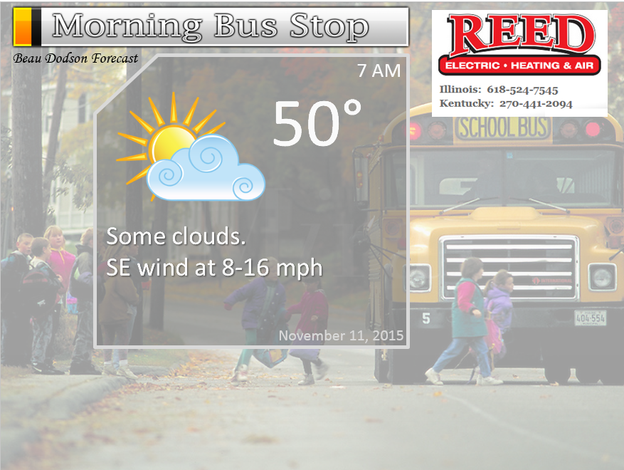
Tuesday night – Some increase in clouds.
Temperatures: Lows in the upper 40s to lower 50s.
Winds: South winds at 5 mph.
What is the chance for precipitation? 10%
Coverage of precipitation? Isolated perhaps western counties
My confidence in this part of the forecast verifying is high
Should I cancel my outdoor plans? No
Is severe weather expected? No
What impact is expected? None
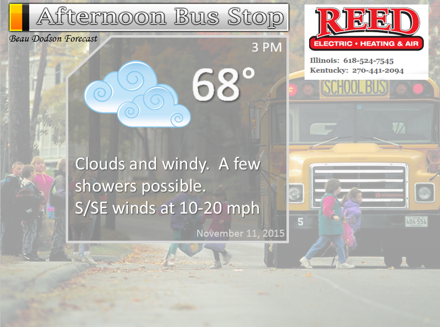
Wednesday Veterans Day – Increasing clouds and windy at times. A few showers may dot the area during the day. A line of scattered storms is likely to move through the area around 3 pm through 9 pm. Moving from west to east. A few storms could produce strong winds. I can’t rule out an isolated tornado (small risk). As always, monitor updates.
Temperatures: Highs in the 68 to 72 degree range.
Winds: South winds at 10-30 mph. Gusty winds. Gusts above 35 mph will be possible.
What is the chance for precipitation? 30% during the morning and then 60% as the day wears on into the evening hours. From west to east. Storms will be moving at speeds of 50-70 mph.
Coverage of precipitation? Scattered. Perhaps more widespread if the band of precipitation speeds up.
My confidence in this part of the forecast verifying is High
Should I cancel my outdoor plans? Monitor updates. Storms are possible. Can not rule out heavy storms at some point during the afternoon and evening hours.
Is severe weather expected? Monitor updates. Possibly.
What impact is expected? Depending on the speed of the front. Much of the day may be dry and windy. If storms move in faster than a brief period of downpours, gusty winds, lightning, and maybe some intense storms.
Wednesday night – Cloudy. A period of showers and thunderstorms before midnight. A few intense storms not out of the question. Gusty winds. Precipitation ending from west to east as the evening wears on.
Temperatures: Lows in the upper 50s.
Winds: Winds become westerly at 10-25 mph. Gusty
What is the chance for precipitation? 60% before 12 am.
Coverage of precipitation? A period of widespread showers and storms along a cold front.
My confidence in this part of the forecast verifying is medium
Should I cancel my outdoor plans? Evening activities may have to deal with rain and some storms.
Is severe weather expected? Monitor updates, I can’t rule out some intense storms.
What impact is expected? Possibly some evening thunderstorms. Lightning and heavy downpours. Gusty winds. An isolated tornado can’t be ruled out.
Thursday – Partly sunny and cooler. Breezy at times.
Temperatures: Highs in the upper 50s.
Winds: West winds at 10-20 mph. Gusty winds possible.
What is the chance for precipitation? 0%
Coverage of precipitation? None
My confidence in this part of the forecast verifying is Medium
Should I cancel my outdoor plans? No
Is severe weather expected? No
What impact is expected? None
Thursday night – Clear and cool.
Temperatures: Lows in the 30s.
Winds: West winds at 5 mph
What is the chance for precipitation? 0%
Coverage of precipitation? None
My confidence in this part of the forecast verifying is medium
Should I cancel my outdoor plans? No
Is severe weather expected? No
What impact is expected? None
Friday – Mostly sunny.
Temperatures: Highs in the upper 50s.
Winds: West winds at 5-10 mph.
What is the chance for precipitation? 0%
Coverage of precipitation? None
My confidence in this part of the forecast verifying is High
Should I cancel my outdoor plans? No
Is severe weather expected? No
What impact is expected? None
Friday night – Clear and cold. Freeze possible.
Temperatures: Lows in the upper 20s to lower 30s.
Winds: Northwest winds at 5 mph
What is the chance for precipitation? 0%
Coverage of precipitation? None
My confidence in this part of the forecast verifying is medium
Should I cancel my outdoor plans? No
Is severe weather expected? No
What impact is expected? A freeze is possible.
Saturday – Mostly sunny.
Temperatures: Highs in the middle 50s.
Winds: Northwest winds at 5-10 mph.
What is the chance for precipitation? 0%
Coverage of precipitation? None
My confidence in this part of the forecast verifying is High
Should I cancel my outdoor plans? No
Is severe weather expected? No
What impact is expected? None
Saturday night – Clear and cold. Freeze possible.
Temperatures: Lows in the middle 30s.
Winds: South winds at 5 mph
What is the chance for precipitation? 0%
Coverage of precipitation? None
My confidence in this part of the forecast verifying is medium
Should I cancel my outdoor plans? No
Is severe weather expected? No
What impact is expected? Frost possible
Sunday – Partly sunny.
Temperatures: Highs in the upper 50s to lower 60s.
Winds: South winds at 5-10 mph.
What is the chance for precipitation? 0%
Coverage of precipitation? None
My confidence in this part of the forecast verifying is High
Should I cancel my outdoor plans? No
Is severe weather expected? No
What impact is expected? None
Click their ad below to visit their web-site or click here reedelec.com


![]()


Don’t forget to check out the Southern Illinois Weather Observatory web-site for weather maps, tower cams, scanner feeds, radars, and much more! Click here

An explanation of what is happening in the atmosphere over the coming days…
Highlights
1. Strong cold front moves through the region Wednesday afternoon and night
2. Some showers and thunderstorms should accompany the front
3. A few storms could be intense with strong winds. We might have some watches or warnings on Wednesday afternoon and evening.
4. Cooler end to the work week and weekend
Here was my 7 am update via Facebook.
Good morning, everyone. This is the 7 am through 12 pm update.
Special thank you to all of our veterans. Without you this world would be a darker place. Thank you for your service and all you do for this great nation.
Highlights:
1. Windy day (later in the day you go…windier it will be). Wind gusts of 30-40 mph possible late today into this evening.
2. Will it storm? And, will some storms become intense/severe?
We have an interesting weather day unfolding. I would be a lot more worried today if the charts were showing higher CAPE values. CAPE is basically a measure of energy in the atmosphere for thunderstorms to tap into. But, as I have been telling you for the last 3-4 days…CAPE is lacking with this system. Thus, the severe weather chances are tempered.
CAPE should be in the 50 to 300 or 400 range. For comparison the Brookport, Illinois tornado day had CAPE values of 700-1500. A LOT more CAPE than today. The higher the CAPE the more energy in the atmosphere.
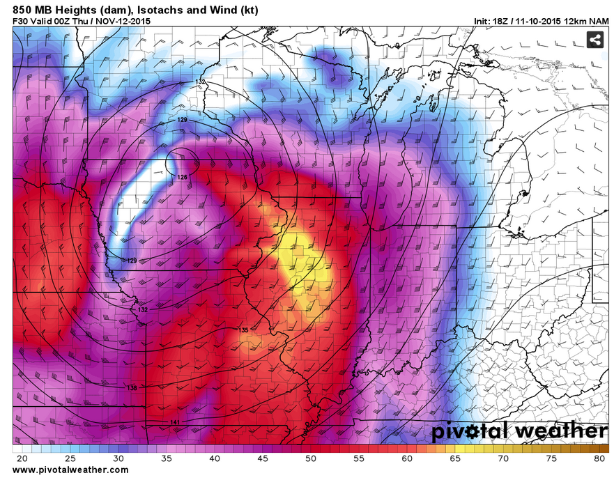
Wind shear is off the charts. Tremendous wind fields aloft will push over the region later today. Top speeds in the jet stream will reach over 160 knots! Low level jet speed will be over 60 knots at 5000 feet. Zoom zoom goes the upper level winds.
That means any storms that form will be moving at speeds of 50-70+ mph. They will be zipping along.
The good news, for our local region, is that CAPE is limited. The bad news is that there will be some CAPE. And, that means we will have to monitor for any thunderstorms that can overcome the shear. We can’t just let our guard down and assume nothing will happen.
Imagine you have a pot of boiling water on your stove. Imagine the steam rising. The air in your kitchen is calm. So, the steam rises straight up. Now, go into your garage and get the leaf blower. Crank it up. Point the nozzle at the steam. What happens? Right. It blows sideways and even blows apart. And, yes your husband or wife might be upset with me.
Now, put that leaf blower down. And lightly blow on the steam. Different outcome. Right?
Imagine that steam is a thunderstorm updraft. In order for thunderstorms to form you must have an updraft. A lifted parcel of air. That air rises into the atmosphere and helps create a cloud. When we have a lot of CAPE that parcel of air can explode upward. Generating huge thunderstorms. But, when CAPE is weak that parcel of airs momentum is also weak. The jet stream today is the leaf blower.
There is the good possibility that the updrafts today will be weak. And, they may not be able to fully overcome the strong shear (winds aloft). In other words, the shear may be too strong for the weak parcels of air to overcome. Thus, we end up with scattered showers and a few thunderstorms vs a bit outbreak of severe weather.
The concern for a weatherman is if some of the updrafts CAN overcome the shear. If that happens then damaging winds will be possible in those storms and perhaps even isolated tornadoes.
Today is one of those days where we pay attention to the weather, we watch and see how everything unfolds this afternoon. I can’t rule out a weather watch of some sort and I can’t rule out some warnings. A watch means severe weather could occur. A warning means severe weather is occurring or will occur shortly.
The overall risk appears limited. However, with the powerful jet stream moving into the region there is the concern that some storms become severe. Thus, we monitor updates.
In my opinion the greatest risk would be over southeast Missouri and southwest Illinois. Then a lesser risk elsewhere. The risk isn’t zero in any of my forecast counties. But, it is less in some areas compared to others. Western counties greater risk vs far eastern counties.
I will be here all day watching the satellite, radars, and current conditions. I will be updating the Live Feed on my new website and on here. If anything changes you will hear about it.
In addition to the above, winds will become strong and gusty today. Expect winds of 10-20 mph as the day wears on with gusts of 30-40 mph. If you have plans on area lakes then keep this in mind. The later in the day the stronger the winds. This is in response to the strong jet stream and the deep area of low pressure to our north. We call these gradient winds. The difference in air pressure will be tight around the area of low pressure moving out of Kansas into Iowa. Tight gradient equals gusty winds.
The timing of the showers and storms.
Showers should develop later this morning and early afternoon over Arkansas and Missouri. I can’t rule out showers (light in nature) in the area between 10 am and 3 pm.
Actual thunderstorms may start moving into southeast Missouri as early as 1 pm to 4 pm. The front appears to have slowed just a little bit. So, keep that in mind. Timing may need to be adjusted.
For southwest Illinois perhaps 3 pm to 7 pm. Then spreading east from there.
That means western Kentucky and northwest Tennessee may have to wait until 4 pm through 9 pm. Again, these times are fluid. And, you can always have storms form ahead of the line. We may have two lines if some of the data is correct.
There is one set of guidance that shows everything 2-4 hours later than the above. For now, I will leave it alone.
The whole system should be gone from my forecast area after midnight.
I will post a few graphics below.
Notice my interactive city view radars now have the option to click on the watches and warnings. When you click on them the text of the watch or warning will pop up. A few other new features, as well.
Radars
http://weatherobservatory.com/weather-radar.htm
End of the 7 am update.
Below is the previous update.
The big weather story will be a cold front that will push through our region on Wednesday afternoon and Wednesday night. This front is one of the stronger ones of the fall season, thus far. It will extend from a deep area of low pressure over Iowa.
Wind fields aloft with this system will be quite strong. Fortunately, instability is forecast to be lacking. I say fortunately because if instability was large then we would be talking about a significant outbreak of severe weather.
Here is the wind fields for the 5000′ level. As Jim Rasor mentioned, you might be able to actually hear a roar aloft from these winds. The winds will be in the 50-60 knot range. Often times you can hear the winds as a roar. It would be aloft.
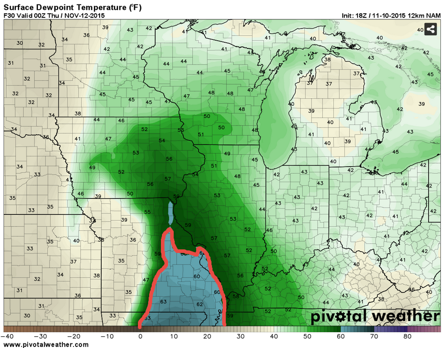
Let me show you the dew points. Remember, in the fall and winter I am looking for dew points (moisture) in the upper 50s to lower 60s. That is enough for some severe weather. The area in blue would be the 60+ dew points. That means we need to pay attention.
This is for 6 pm on Wednesday.
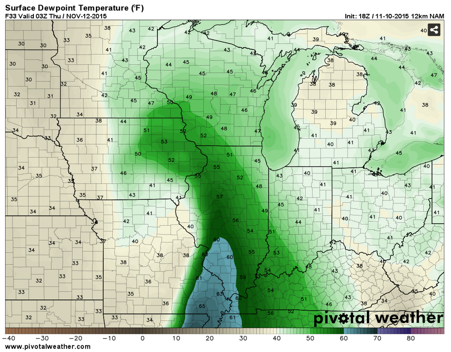
Then this dew point map below is for the 7-8 pm time frame. See how the higher dew points are moving eastward through our region
As it stands, there will be enough instability for at least a few storms becoming strong to severe. Remember, by the NWS definition a severe thunderstorm must produce 58 mph winds or greater. A few storms on Wednesday afternoon and night could produce damaging wind gusts. It would not take much momentum to bring some of those stronger winds aloft down to the surface.
If the storms mature enough then I also can’t rule out an isolated tornado threat. Typically these types of events produce short lived tornadoes. But, much of this will depend on how much moisture returns on Wednesday. It does appear to be fairly limited in scope.
As always, monitor updates for possible watches and warnings. I would not be surprised if there were a few on Wednesday afternoon and evening.
As far as timing
Poplar Bluff area needs to monitor 1 pm through 4 pm
Cape Girardeau needs to monitor from 3 pm through 7 pm
Paducah, Marion, Harrisburg, and Metropolis perhaps 5 pm through 8 pm
Owensboro, Evansville, Madisonville, Cadiz, and Murray perhaps 6 pm through 9 or 10 pm
THESE ARE NOT SET IN STONE. Times could change. That is how the guidance lines up at this time.
Right now appears that a few showers may develop as early as Wednesday morning and early afternoon over southeast Missouri. But, the main time frame of concern should be between 1 to 3 pm through 9 to 11 pm. Starting over southeast Missouri and then spreading eastward.
Some of the data indicates a broken line of storms. Other data indicates a near solid line. This needs to be monitored. Isolated storms have a tendency to produce more severe weather.
Let me show you a couple of model future-cast radar images. What radar “might” look like tomorrow. Notice how the line is broken. That could be supercells. Let’s keep an eye on Wednesday afternoon and evening. Images are from weatherbell.com The colors represent rain and storms. You can imagine where the cold front is. Right behind the precipitation. The front sweeps eastward. This is the 5-6 pm radar show. Potentially. Don’t take this as gospel. Take it as guidance.
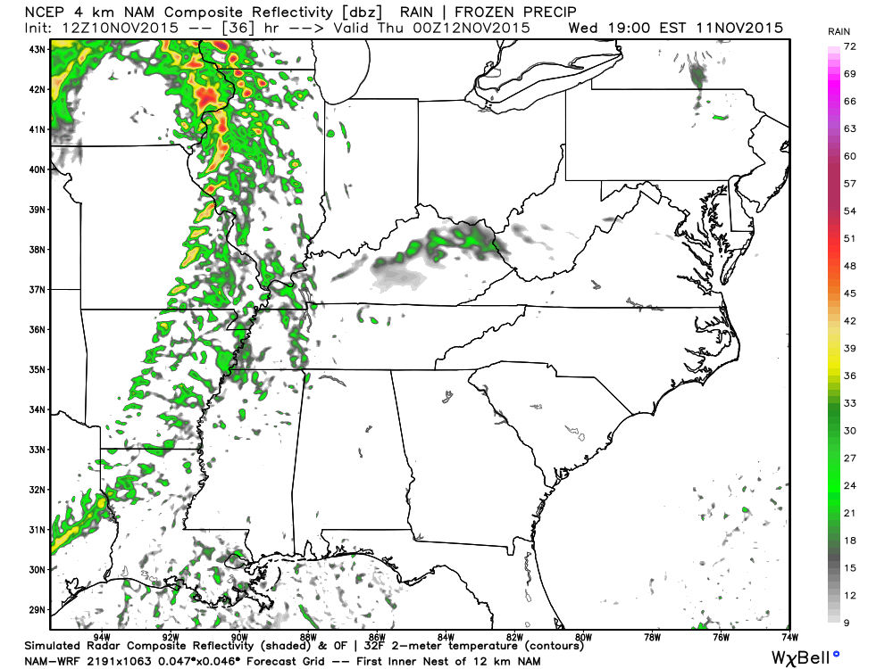
Then let’s move ahead to around 7-8 pm. Again, don’t take this as gospel. Line could speed up or be a little slower.
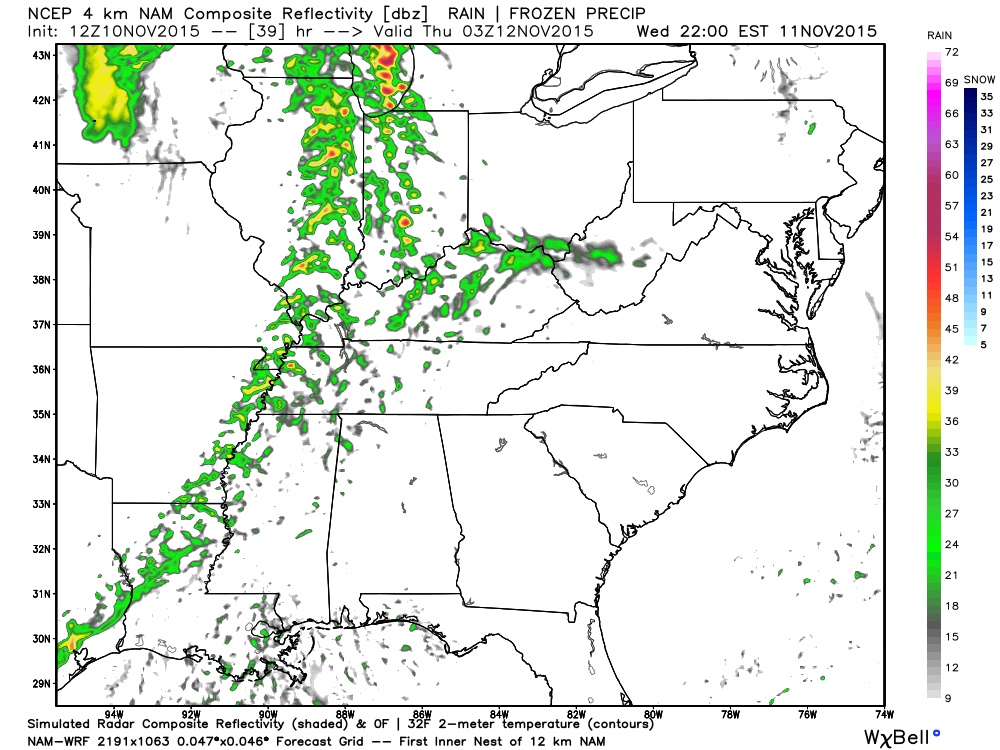
Then, finally this is around 10 pm Storms are moving away from our region
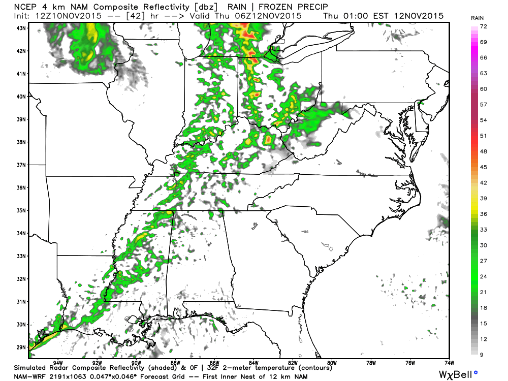
Storms will be moving rapidly east/northeast at speeds of 50-70 mph. Fast movers, to say the least.
Right now it appears that the storms should move over the Mississippi River into southern Illinois and western Kentucky somewhere between 4 pm and 8 pm. Earlier further west in the region and later further east in the region.
I will adjust timing on Wednesday once I take a look at the latest surface charts.
We will cool down behind the cold front. Expect Thursday through Sunday to deliver dry and cool conditions. Highs mostly in the 50s with lows mostly in the 30s. Can’t rule out some more 20s by Saturday morning. Some of you experienced 20s over the past week.
Our next weather maker may arrive early next week. Still a long way off. Plenty of time to monitor.

No major changes in this update.

Main concern will be thunderstorms on Wednesday afternoon and Wednesday night. Some of these storms could be quite intense. Let’s monitor.

Gusty winds on Wednesday. Expect 10-30 mph winds over the region. Boaters use care.
A band of thunderstorms on Wednesday afternoon/Wednesday night could produce some intense weather, as well. Monitor updates.

The wild card will be Wednesday/Wednesday night. How much moisture can return northward from the Gulf of Mexico. Dew points into the 50s and 60s will be possible. This would be fuel for thunderstorms, if they indeed reach those numbers. Severe weather can’t be ruled out on Wednesday.

Frost/Freeze possible on Friday or Saturday morning of this new work week.

How much precipitation should we expect over the next few days?
Fast moving showers and thunderstorms could produce 0.25″-0.50″ of precipitation on Wednesday. The fast movement should preclude larger rainfall amounts and some areas may not even reach the above numbers.

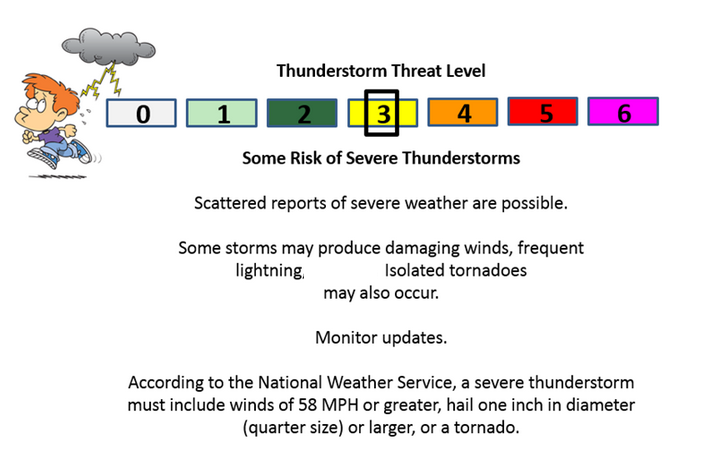
Can we expect severe thunderstorms over the next 24 to 48 hours? Remember that a severe thunderstorm is defined as a thunderstorm that produces 58 mph winds or higher, quarter size hail or larger, and/or a tornado.
Thunderstorm threat level will be 2/3 on Wednesday. Monitor updates.
.
Wednesday: A few storms could reach severe limits on Wednesday afternoon and night. A watch is possible and some warnings.
Thursday: Severe weather is not anticipated.
Friday: Severe weather is not anticipated.
Saturday: Severe weather is not anticipated.
The outlook below is for Wednesday/Wednesday night. I had to white out the hail part on the graphic. Hail should not be a problem.

We have regional radars and local city radars – if a radar does not seem to be updating then try another one. Occasional browsers need their cache cleared. You may also try restarting your browser. That usually fixes the problem. Occasionally we do have a radar go down. That is why I have duplicates. Thus, if one fails then try another one.
If you have any problems then please send me an email beaudodson@usawx.com
WEATHER RADAR PAGE – Click here —
We also have a new national interactive radar – you can view that radar by clicking here.
Local interactive city radars include St Louis, Mt Vernon, Evansville, Poplar Bluff, Cape Girardeau, Marion, Paducah, Hopkinsville, Memphis, Nashville, Dyersburg, and all of eastern Kentucky – these are interactive radars. Local city radars – click here
NOTE: Occasionally you will see ground clutter on the radar (these are false echoes). Normally they show up close to the radar sites – including Paducah.

Regional Radar – Click on radar to take you our full radar page.


Live Lightning Data – zoom and pan: Click here
Live Lightning Data with sound (click the sound button on the left side of the page): Click here

I also set up a storm tracking page with additional links (use during active weather for quick reference)
Storm Tracking Tool Page
![]()
Current WARNINGS (a warning means take action now). Click on your county to drill down to the latest warning information. Keep in mind that there can be a 2-3 minute delay in the updated warning information.
I strongly encourage you to use a NOAA Weather Radio or warning cell phone app for the most up to date warning information. Nothing is faster than a NOAA weather radio.


Color shaded counties are under some type of watch, warning, advisory, or special weather statement. Click your county to view the latest information.

Missouri Warnings

Illinois Warnings

Kentucky Warnings

Here is the official 6-10 day and 8-14 day temperature and precipitation outlook. Check the date stamp at the top of each image (so you understand the time frame).
The forecast maps below are issued by the Weather Prediction Center (NOAA).


The latest 8-14 day temperature and precipitation outlook. Note the dates are at the top of the image. These maps DO NOT tell you how high or low temperatures or precipitation will be. They simply give you the probability as to whether temperatures or precipitation will be above or below normal.


Here are the current river stage forecasts. You can click your state and then the dot for your location. It will bring up the full forecast and hydrograph.
Click Here For River Stage Forecasts…
Here are some current forecast hydrographs. These will be updated each day with new information.


Smithland Lock and Dam

Paducah, Kentucky Forecast Stage

Cairo, Illinois

Cape Girardeau, Missouri

Who do you trust for your weather information and who holds them accountable?
I have studied weather in our region since the late 1970’s. I have 37 years of experience in observing our regions weather patterns. My degree is in Broadcast Meteorology from Mississippi State University and an Associate of Science (AS). I am currently working on my Bachelor’s Degree in Geoscience.
My resume includes:
Member of the American Meteorological Society.
NOAA Weather-Ready Nation Ambassador.
Meteorologist for McCracken County Emergency Management.
I own and operate the Southern Illinois Weather Observatory.
Recipient of the Mark Trail Award, WPSD Six Who Make A Difference Award, Kentucky Colonel, and the Caesar J. Fiamma” Award from the American Red Cross.
In 2009 I was presented with the Kentucky Office of Highway Safety Award.
Recognized by the Kentucky House of Representatives for my service to the State of Kentucky leading up to several winter storms and severe weather outbreaks.
I am also President of the Shadow Angel Foundation which serves portions of western Kentucky and southern Illinois.
There is a lot of noise on the internet. A lot of weather maps are posted without explanation. Over time you should learn who to trust for your weather information.
My forecast philosophy is simple and straight forward.
- Communicate in simple terms
- To be as accurate as possible within a reasonable time frame before an event
- Interact with you on Twitter, Facebook, and the blog
- Minimize the “hype” that you might see on television or through other weather sources
- Push you towards utilizing wall-to-wall LOCAL TV coverage during severe weather events
I am a recipient of the Mark Trail Award, WPSD Six Who Make A Difference Award, Kentucky Colonel, and the Caesar J. Fiamma” Award from the American Red Cross. In 2009 I was presented with the Kentucky Office of Highway Safety Award. I was recognized by the Kentucky House of Representatives for my service to the State of Kentucky leading up to several winter storms and severe weather outbreaks.
If you click on the image below you can read the Kentucky House of Representatives Resolution.

Many of my graphics are from www.weatherbell.com – a great resource for weather data, model data, and more


You can sign up for my AWARE email by clicking here I typically send out AWARE emails before severe weather, winter storms, or other active weather situations. I do not email watches or warnings. The emails are a basic “heads up” concerning incoming weather conditions.