We have some great sponsors for the Weather Talk Blog. Please let our sponsors know that you appreciate their support for the Weather Talk Blog.
Milner and Orr Funeral Home and Cremation Services located in Paducah, Kentucky and three other western Kentucky towns – at Milner and Orr they believe in families helping families. You can find Milner and Orr on Facebook, as well.
![]()
.

Wortham Dental Care located in Paducah, Kentucky. The gentle dentist. Mercury free dentistry. They also do safe Mercury removal. You can find Wortham Dental Care on Facebook, as well
.

For all of your families eye care needs. Visit their web-site here. Or, you can also visit their Facebook page.
.

Endrizzi’s Storm Shelters – For more information click here. Endrizzi Contracting and Landscaping can be found on Facebook, as well – click here
.

Best at Enabling Body Shop Profitability since 1996. Located In Paducah Kentucky and Evansville Indiana; serving all customers in between. They provide Customer Service, along with all the tools necessary for body shops to remain educated and competitive. Click the logo above for their main web-site. You can find McClintock Preferred Finishes on Facebook, as well
.

Duck/goose decoys? Game calls? Optics? We have you covered! Click the logo above or visit Final Flight on Facebook, as well.

This forecast update covers far southern Illinois, far southeast Missouri, and far western Kentucky. See the coverage map on the right side of the blog.
Remember that weather evolves. Check back frequently for updates, especially during active weather.
Monday night – Decreasing cloudiness. Cool. Patchy fog possible.
Temperatures: Lows in the upper 30s to lower 40s (eastern counties for the lower 40s). Perhaps a few mid 30s over southern Illinois and western Kentucky.
Winds: Southeast winds at 0-5 mph.
What is the chance for precipitation? 0%
Coverage of precipitation? None
My confidence in this part of the forecast verifying is medium
Should I cancel my outdoor plans? No
Is severe weather expected? No
What impact is expected? None
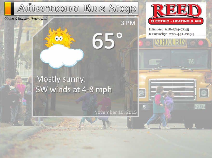
Tuesday – Partly sunny. Patchy morning fog possible. Especially over our eastern counties on the fog.
Temperatures: Highs in the upper 50s to lower 60s
Winds: South and southwest winds at 5-10 mph.
What is the chance for precipitation? 0%
Coverage of precipitation? None
My confidence in this part of the forecast verifying is Medium
Should I cancel my outdoor plans? No
Is severe weather expected? No
What impact is expected? None
Tuesday night – Some increase in clouds.
Temperatures: Lows in the upper 40s to lower 50s.
Winds: South winds at 5 mph.
What is the chance for precipitation? 10%
Coverage of precipitation? Isolated perhaps western counties
My confidence in this part of the forecast verifying is medium
Should I cancel my outdoor plans? No
Is severe weather expected? No
What impact is expected? None
Wednesday Veterans Day – Increasing clouds and windy at times. Some question on the timing of the precipitation. New data holds off precipitation until the evening hours. This will need to be monitored. A chance of at least a few showers and thunderstorms as the day wears on. Perhaps better chances late in the day into the evening hours.
Temperatures: Highs in the 68 to 72 degree range.
Winds: South winds at 10-30 mph. Gusty winds. Gusts above 35 mph will be possible.
What is the chance for precipitation? 40% as the day wears on into the evening hours. From west to east. Storms will be moving at speeds of 50-70 mph.
Coverage of precipitation? Scattered. Perhaps more widespread if the band of precipitation speeds up.
My confidence in this part of the forecast verifying is High
Should I cancel my outdoor plans? Monitor updates. Storms are possible. Can not rule out heavy storms at some point during the afternoon and evening hours.
Is severe weather expected? Monitor updates. Possibly.
What impact is expected? Depending on the speed of the front. Much of the day may be dry and windy. If storms move in faster than a brief period of downpours, gusty winds, lightning, and maybe some intensestorms.
Wednesday night – Cloudy. A period of showers and thunderstorms. A few intense storms not out of the question. Gusty winds.
Temperatures: Lows in the upper 50s.
Winds: Winds become westerly at 10-25 mph. Gusty
What is the chance for precipitation? 60% before 2 am.
Coverage of precipitation? A period of widespread showers and storms along a cold front.
My confidence in this part of the forecast verifying is medium
Should I cancel my outdoor plans? Evening activities may have to deal with rain.
Is severe weather expected? Monitor updates, I can’t rule out some intense storms.
What impact is expected? Possibly some evening thunderstorms. Lightning and heavy downpours. Gusty winds
Thursday – Partly sunny and cooler. Breezy at times.
Temperatures: Highs in the upper 50s.
Winds: West winds at 10-20 mph. Gusty winds possible.
What is the chance for precipitation? 0%
Coverage of precipitation? None
My confidence in this part of the forecast verifying is Medium
Should I cancel my outdoor plans? No
Is severe weather expected? No
What impact is expected? None
Thursday night – Clear and cool.
Temperatures: Lows in the 30s.
Winds: West winds at 5 mph
What is the chance for precipitation? 0%
Coverage of precipitation? None
My confidence in this part of the forecast verifying is medium
Should I cancel my outdoor plans? No
Is severe weather expected? No
What impact is expected? None
Friday – Mostly sunny.
Temperatures: Highs in the upper 50s.
Winds: West winds at 5-10 mph.
What is the chance for precipitation? 0%
Coverage of precipitation? None
My confidence in this part of the forecast verifying is High
Should I cancel my outdoor plans? No
Is severe weather expected? No
What impact is expected? None
Friday night – Clear and cold. Freeze possible.
Temperatures: Lows in the upper 20s to lower 30s.
Winds: Northwest winds at 5 mph
What is the chance for precipitation? 0%
Coverage of precipitation? None
My confidence in this part of the forecast verifying is medium
Should I cancel my outdoor plans? No
Is severe weather expected? No
What impact is expected? A freeze is possible.
Saturday – Mostly sunny.
Temperatures: Highs in the 50s.
Winds: Northwest winds at 5-10 mph.
What is the chance for precipitation? 0%
Coverage of precipitation? None
My confidence in this part of the forecast verifying is High
Should I cancel my outdoor plans? No
Is severe weather expected? No
What impact is expected? None
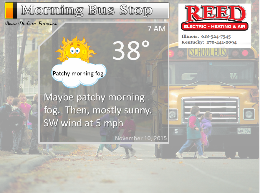
The School Bus Stop Forecast is sponsored by Reed Electric, Heating & Air in Metropolis, IL offers full electrical, heating, and air conditioning services, as well as automatic transfer generators. Our licensed and insured service technicians serve Southern Illinois and Western KY with 24 hour service. Free estimates available for all new installations!
Click their ad below to visit their web-site or click here reedelec.com


![]()


Don’t forget to check out the Southern Illinois Weather Observatory web-site for weather maps, tower cams, scanner feeds, radars, and much more! Click here

An explanation of what is happening in the atmosphere over the coming days…
Highlights
1. Let’s talk about Wednesday
2. Cooler behind the front on Thursday-Sunday.
Severe thunderstorms in the forecast? Some are calling for an outbreak. But, not so fast! Let’s talk about that.
I messed up on the cloud cover today for southeast Missouri, southern Illinois and far western Kentucky. The bulk of the clouds and showers remained further east than anticipated. Eastern counties had rain and thick clouds. Close, but no cigar for everyone else. I was off by a few counties. Doh! To the corner.
Temperatures Sunday night were also MUCH colder than anticipated across some of our counties. Many counties dipped into the 20s over southeast Missouri and southern Illinois. Calm winds and clear sky conditions were the culprit. Temperatures dropped like a rock. I was thinking lower to middle 30s over southern Illinois and middle to upper 30s to around 40 elsewhere.
The big story that everyone is talking about is what the Storm Prediction Center has forecast for Veteran’s Day. They have outlined our entire region for severe thunderstorms and tornadoes.
Wednesday won’t be an all day rain event. It will be a period of showers and thunderstorms racing through the region. Also, Wednesday will be a windy day with winds of 10-30 mph even without showers and storms. This is because of the pressure gradient developing with our storm to the north.
And, for a day three outlook they have pretty much gone all in. Meaning, a strongly worded outlook with higher probabilities. As a matter of fact, this is one of the stronger outlooks of 2015 for our region.
There are some limiting factors on Wednesday that make for a low confidence forecast. Moisture return (dew point) is missing. And, CAPE (energy/instability) values are missing. For a big outbreak you need both. The question is how quick can dew points recover from the 30s on Tuesday. Dew points are a measure of moisture in the atmosphere. During the fall months I become concerned when dew points rise into the 50s and 60s. That is typically a sign of severe weather.
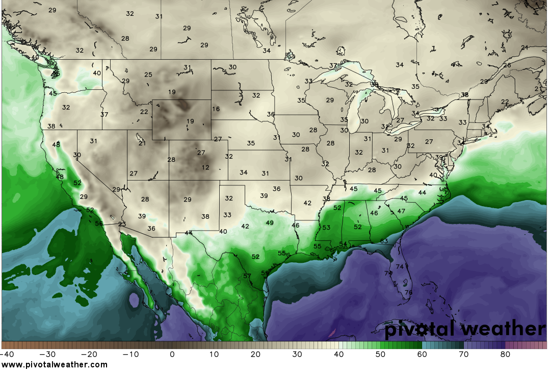
Let’s look at a few dew point maps
This is the dew point map on Monday/Tuesday. Notice the 30s over our region? Very low dew points. That means dry air. Can you find the warm and moist air? Remember, we are looking for 50s and 60s when it comes to dew points in the fall and winter months. The blue colors represent 60s. Way way down in the Gulf of Mexico. Unusually far south. That means that moist air has quite a long way to travel before it returns to our region.
Click maps for larger views.
Okay, this next map is for Wednesday evening. Wow, dew points jumped northward. That is because of the deep area of low pressure over Iowa. See how they curve up and over Iowa? Low pressure rotates counterclockwise. Thus, a low in Iowa would be pulling up Gulf of Mexico air. At quite the high rate of speed, I might add. This is partly because of the flat Mississippi River Delta area. Air can freely move rapidly northward. We even have some 60 dew points in our region. IF this guidance is correct. Thin band of higher dew points. Right ahead of the cold front. Will it be enough to spark some severe weather concerns? Perhaps
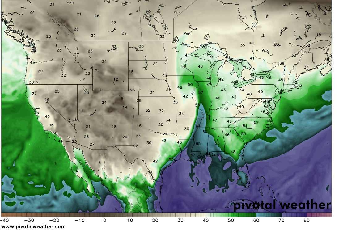
Here, I drew an illustration for you. See how the air moves up and over the area of low pressure?
All of the model data indicates a narrow window of opportunity for this big deep low pressure center to suck moisture northward. Low pressure rotates counter-clockwise. Thus, a low over Iowa will pull moisture northward out of the Gulf of Mexico. That narrow window would be during the afternoon and evening on Wednesday. Models are showing at least 50s returning to the region (dew points) and maybe lower 60s. This would be right ahead of our cold front.
If dew points to rise into the 50s and lower 60s then that means CAPE values of 50 to perhaps as high as 300/400. Not much. For severe weather, during the fall months, you typically don’t need a lot of CAPE. Even 200-400 can be enough, under the right circumstances. But, the higher the CAPE numbers the more concerned a forecaster becomes. During spring and summer CAPE values can easily top 2000.
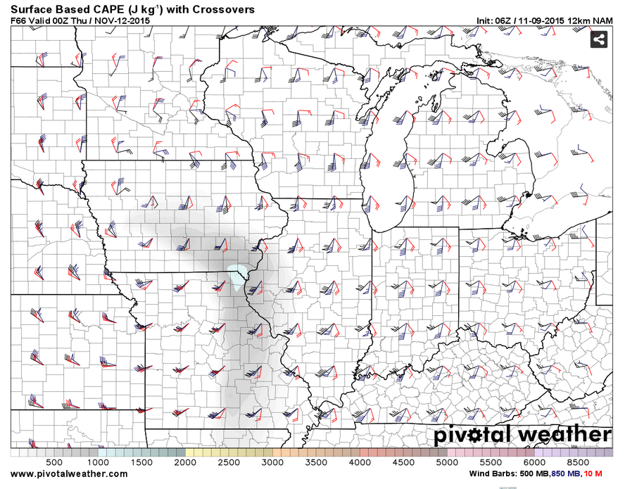
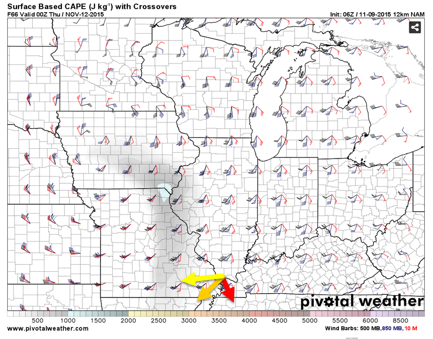
Speaking of CAPE. Look at the meager CAPE numbers appearing on the models for Wednesday afternoon into Wednesday night. Not much, but perhaps just enough for some concern. I checked BUFKIT (a tool that meteorologists use to dig deeper into the data) and it indicates CAPE readings of 200-400 over our region ahead of the cold front.
Here are the CAPE numbers over-layed the wind fields at different heights of the atmosphere. Notice how they turn with height? The barbs begin coming out of the south then turn more southwesterly and then turn more westerly. The CAPE is shaded in gray. Hard to see.
I colored the wind directions on this one. These are the winds at 5000′ and then going upward to 18,000′. Notice the turning?
This system will have very strong wind fields aloft. This mean a lot of shear. There is such a thing as too much shear. Shear is the increase of wind speed with height and/or a difference in wind direction with height. For example, at the surface you can have southeast winds and then at 5000′ you can have southwest winds and then at 18,000 feet you can have westerly winds. This is direction shear. A turning of wind direction as you move higher into the atmosphere. Imagine in your mind what I just described. Can you picture how this causes a turning motion?
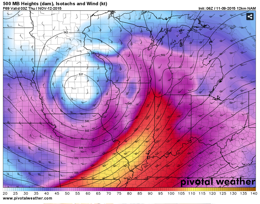
Look at this jet max moving our region. A jet max is an intense area of winds located within the jet stream. It is where the winds are quite higher than surrounding areas. Very impressive jet stream over our region Wednesday evening and night. Winds over 120 knots at 18,000′. That bright yellow area is the jet streak. A jet streak is one feature meteorologists use to monitor the potential for severe weather. We certainly do have strong winds over our region.
Too much shear with little in the way of CAPE (energy/instability) can cause thunderstorms to tear apart. Weak thunderstorms can’t handle the strong shear. This is a possibility on Wednesday. Too much shear and not enough CAPE.
A lot of forecasters, behind the scenes, are struggling with the Wednesday forecast. Some of the ingredients for severe weather are definitely going to be present. But, some are seriously lacking. It is too early to start talking about this being a big severe weather event. No need to scare people. Too much uncertainty remains.
This is my approach and forecast philosophy. Ramp up and not down. That means you don’t put out a 12″ snowfall forecast 3 days in advance. Only to become a 1-3″ snowfall forecast when the event arrives. Get my point? Ramp up and not down. Don’t overstate the potential before we know the outcome.
With that said, this is what I am thinking.
A line or broken line of showers and thunderstorms will develop from Iowa down into Missouri and Arkansas on Wednesday morning and afternoon. The individual storms within the line will move at speeds of 50-70 mph towards the northeast. Fast movers. The line itself will shift eastward at speeds of 35-50 mph.
The latest data brings this line of storms into southeast Missouri after 3 pm on Wednesday. This will need to be monitored. The timing of the front is still in question. And then races it eastward over our region Wednesday evening and early into the night.
If the line of storms can actually develop and intensify then severe weather will certainly be possible. Winds aloft will be ripping along. It would not take much to bring some of those wind gusts down to the surface. This will depend on how well the thunderstorms mature. The more mature storms on Wednesday will produce severe weather. The question is how much they mature and how many of them mature
I will know a lot more on Tuesday. Once I see how much the Gulf of Mexico recovers from all of this cold air present today. Low dew points have pushed way south…into the Gulf of Mexico. Forecasters need to see these numbers recover some before jumping on-board for widespread severe weather.
If the dew points recover then we are in trouble. And that is the big question for this event.
Bottom line…
Monitor updates. Remember that forecasts are fluid. They are not set in stone. They evolve as we look at fresh data.
1. Expect a strong cold front on Wednesday with gusty winds even outside of showers and storms. Winds of 15-35 mph.
2. Timing will need to be fine tuned as we move forward.
3. It will exit the region Wednesday night. First over our western counties in the late afternoon or evening and then our eastern counties later into the night.
4. A few storms could produce strong winds (greater than 45 mph) Perhaps even damaging wind.
Rainfall totals should be 0.25″-0.50″. The fast movement of the system should preclude large rainfall totals. Some areas won’t even pick up that much rain.
Temperature will dip into the 30s by late in the week. Another freeze possible on Saturday morning. We could see some 20s for overnight lows.
I am forecasting a colder than normal December. I have been forecasting a warmer than normal November with above normal precipitation for November, as well. We are off to a decent start on both of those counts. We still need more rain. So, keep it coming!

Updated timing of Wednesday’s storms.

Main concern will be thunderstorms on Wednesday and Wednesday night. Some of these storms could be quite intense. Let’s monitor.

Gusty winds on Wednesday. Expect 10-30 mph winds over the region. Boaters use care.
A band of thunderstorms on Wednesday/Wednesday night could produce some intense weather, as well. Monitor updates.

The wild card will be Wednesday/Wednesday night. How much moisture can return northward from the Gulf of Mexico. Dew points into the 50s and 60s will be possible. This would be fuel for thunderstorms, if they indeed reach those numbers. Severe weather can’t be ruled out on Wednesday.

Frost/Freeze possible on Friday or Saturday morning of this new work week.

How much precipitation should we expect over the next few days?
Fast moving showers and thunderstorms could produce 0.25″-0.50″ of precipitation on Wednesday. The fast movement should preclude larger rainfall amounts and some areas may not even reach the above numbers.

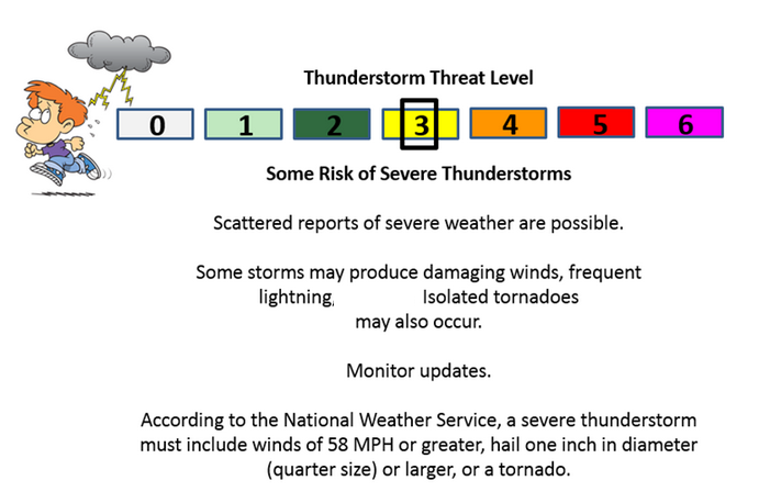
Can we expect severe thunderstorms over the next 24 to 48 hours? Remember that a severe thunderstorm is defined as a thunderstorm that produces 58 mph winds or higher, quarter size hail or larger, and/or a tornado.
Thunderstorm threat level will be ZERO for Tuesday. The threat level will be 2/3 on Wednesday. Monitor updates.
.
Tuesday: Severe weather is not anticipated.
Wednesday: A few storms could reach severe limits on Wednesday afternoon or night.
Thursday: Severe weather is not anticipated.
Friday: Severe weather is not anticipated.
Saturday: Severe weather is not anticipated.
The outlook below is for Wednesday/Wednesday night. I had to white out the hail part on the graphic. Hail should not be a problem.

We have regional radars and local city radars – if a radar does not seem to be updating then try another one. Occasional browsers need their cache cleared. You may also try restarting your browser. That usually fixes the problem. Occasionally we do have a radar go down. That is why I have duplicates. Thus, if one fails then try another one.
If you have any problems then please send me an email beaudodson@usawx.com
WEATHER RADAR PAGE – Click here —
We also have a new national interactive radar – you can view that radar by clicking here.
Local interactive city radars include St Louis, Mt Vernon, Evansville, Poplar Bluff, Cape Girardeau, Marion, Paducah, Hopkinsville, Memphis, Nashville, Dyersburg, and all of eastern Kentucky – these are interactive radars. Local city radars – click here
NOTE: Occasionally you will see ground clutter on the radar (these are false echoes). Normally they show up close to the radar sites – including Paducah.

Regional Radar – Click on radar to take you our full radar page.


Live Lightning Data – zoom and pan: Click here
Live Lightning Data with sound (click the sound button on the left side of the page): Click here

I also set up a storm tracking page with additional links (use during active weather for quick reference)
Storm Tracking Tool Page
![]()
Current WARNINGS (a warning means take action now). Click on your county to drill down to the latest warning information. Keep in mind that there can be a 2-3 minute delay in the updated warning information.
I strongly encourage you to use a NOAA Weather Radio or warning cell phone app for the most up to date warning information. Nothing is faster than a NOAA weather radio.


Color shaded counties are under some type of watch, warning, advisory, or special weather statement. Click your county to view the latest information.

Missouri Warnings

Illinois Warnings

Kentucky Warnings

Here is the official 6-10 day and 8-14 day temperature and precipitation outlook. Check the date stamp at the top of each image (so you understand the time frame).
The forecast maps below are issued by the Weather Prediction Center (NOAA).


The latest 8-14 day temperature and precipitation outlook. Note the dates are at the top of the image. These maps DO NOT tell you how high or low temperatures or precipitation will be. They simply give you the probability as to whether temperatures or precipitation will be above or below normal.


Here are the current river stage forecasts. You can click your state and then the dot for your location. It will bring up the full forecast and hydrograph.
Click Here For River Stage Forecasts…
Here are some current forecast hydrographs. These will be updated each day with new information.


Smithland Lock and Dam

Paducah, Kentucky Forecast Stage

Cairo, Illinois

Cape Girardeau, Missouri

Who do you trust for your weather information and who holds them accountable?
I have studied weather in our region since the late 1970’s. I have 37 years of experience in observing our regions weather patterns. My degree is in Broadcast Meteorology from Mississippi State University and an Associate of Science (AS). I am currently working on my Bachelor’s Degree in Geoscience.
My resume includes:
Member of the American Meteorological Society.
NOAA Weather-Ready Nation Ambassador.
Meteorologist for McCracken County Emergency Management.
I own and operate the Southern Illinois Weather Observatory.
Recipient of the Mark Trail Award, WPSD Six Who Make A Difference Award, Kentucky Colonel, and the Caesar J. Fiamma” Award from the American Red Cross.
In 2009 I was presented with the Kentucky Office of Highway Safety Award.
Recognized by the Kentucky House of Representatives for my service to the State of Kentucky leading up to several winter storms and severe weather outbreaks.
I am also President of the Shadow Angel Foundation which serves portions of western Kentucky and southern Illinois.
There is a lot of noise on the internet. A lot of weather maps are posted without explanation. Over time you should learn who to trust for your weather information.
My forecast philosophy is simple and straight forward.
- Communicate in simple terms
- To be as accurate as possible within a reasonable time frame before an event
- Interact with you on Twitter, Facebook, and the blog
- Minimize the “hype” that you might see on television or through other weather sources
- Push you towards utilizing wall-to-wall LOCAL TV coverage during severe weather events
I am a recipient of the Mark Trail Award, WPSD Six Who Make A Difference Award, Kentucky Colonel, and the Caesar J. Fiamma” Award from the American Red Cross. In 2009 I was presented with the Kentucky Office of Highway Safety Award. I was recognized by the Kentucky House of Representatives for my service to the State of Kentucky leading up to several winter storms and severe weather outbreaks.
If you click on the image below you can read the Kentucky House of Representatives Resolution.

Many of my graphics are from www.weatherbell.com – a great resource for weather data, model data, and more


You can sign up for my AWARE email by clicking here I typically send out AWARE emails before severe weather, winter storms, or other active weather situations. I do not email watches or warnings. The emails are a basic “heads up” concerning incoming weather conditions.