We have our first sponsor for the blog. Milner and Orr Funeral Home and Cremation Services located in Paducah, Kentucky and three other western Kentucky towns – at Milner and Orr they believe in families helping families.
![]()

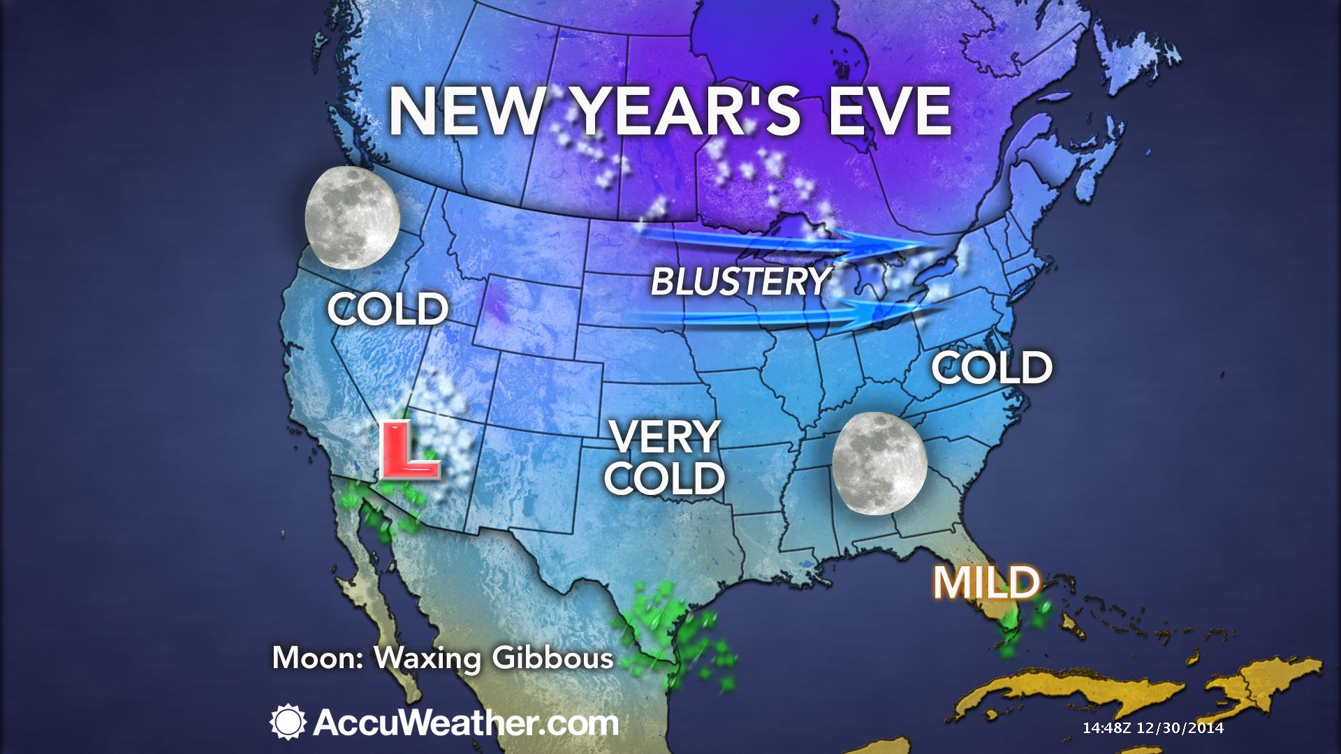
This forecast update covers far southern Illinois, far southeast Missouri, and far western Kentucky. See the coverage map on the right side of the blog.
Wednesday – Quite a bit of sun with a few clouds. High temperature will mainly be in the 20’s. West/northwest winds during the morning at 5-10 mph. Winds will become southwesterly during the afternoon at 5-10 mph
Wednesday night – Mostly clear sky conditions. Chilly once again. Low temperatures will dip into the teens and lower 20’s. Southwest winds at 5-10 mph.
Thursday – Morning sun with increasing clouds during the afternoon hours. High temperatures will be in the 30’s. Southwest winds at 5-10 mph.
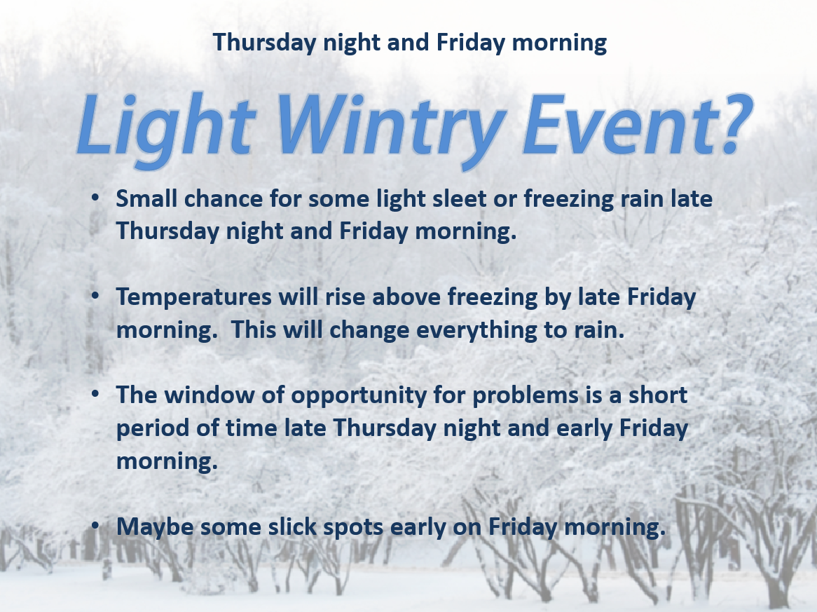
Thursday night – Becoming cloudy. A small chance for a light wintry mix late at night. Low confidence in this part of the forecast. Low temperatures will range from 28 to 32 degrees. Chance of precipitation on Thursday night will be 20%. Southwest winds at 5-10 mph.
Friday – Cloudy with a chance for a light wintry mix in the morning and then a chance of rain throughout the day. Rain chances increase even more on Friday night and Saturday. Some thunder possible. Temperatures will rise into the upper 30’s during the day on Friday and hold steady or rise Friday night. Highs will vary quite a bit on Saturday. We may see some 50’s over parts of western Kentucky and a bit cooler over southeast Missouri and southern Illinois.
Winds on Friday will be out of the south/southwest and may turn more east/southeasterly during the afternoon hours.
Chance of precipitation Friday morning will be 30% increasing to 60% by late afternoon and near 100% Friday night and Saturday.
Temperatures on Friday into Saturday night will depend on the track of the area of low pressure.

Current Temperatures Around The Local Area


An explanation of what is happening in the atmosphere over the coming days.
High pressure dominates our current weather. That means chilly day time temperatures and cold overnight temperatures. Nothing extreme or out of the ordinary. Typical winter temperatures. The true arctic air is located to our north and west. Many states have been well below zero – thankfully we are not dealing with those temperatures.
Our weather will continue to be controlled by high pressure through Thursday evening.
I do not foresee any travel problems for today, tonight, Thursday morning or Thursday afternoon.
We will have to monitor late Thursday night and Friday morning for a small chance of precipitation returning to the area. Low confidence in the precipitation moving in before temperatures rise above freezing. But, worth watching.
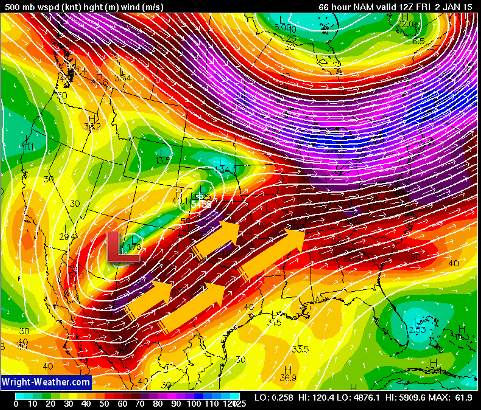
By Thursday night we will see a southwest flow start to develop over our region. That means that winds will turn out of the southwest at upper levels and this will spread moisture into our region.
Here is the 500 mb map (thousands of feet up in the atmosphere – this is how the wind is going to flow on Thursday night and Friday). You can see the arrows moving into our region from the southwest. Lots of moisture will be brought up by the southwest winds.
Be thankful that we don’t have a deep layer of cold air over our region. Otherwise, this would be quite the ice maker. The cold air over our region through Thursday night will be shallow and will quickly erode away as the warmer air pushes into our local area from the south and southwest.
There will at least be a small chance of some light wintry mix on Thursday night or Friday morning. What is more likely is widespread rain by Friday afternoon and night. This rain will last into Saturday night. Some thunderstorms are even possible!
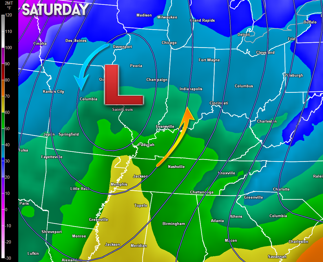
Notice the warm up on Saturday as the low pushes off to our north? That is because an area of low pressure rotates counter-clockwise. If it passes to our north and west then that means we are on the warm side of the low. Temperature scale is on the left side of the image. Colors represent temperatures.
Colder weather will return by Sunday into next week.
I am not tracking any significant snowstorms for our region. Not at this time, at least.
If you have travel plans late Thursday night into Friday morning then check the latest forecast. There may be some adjustments concerning precipitation probabilities. Low confidence in the Thursday night and Friday morning time frame.
Road temperatures will be cold during this time frame. IF (big if) precipitation does develop late Thursday night or Friday morning then it could cause some brief travel problems. Temperatures will rise above freezing later on Friday.
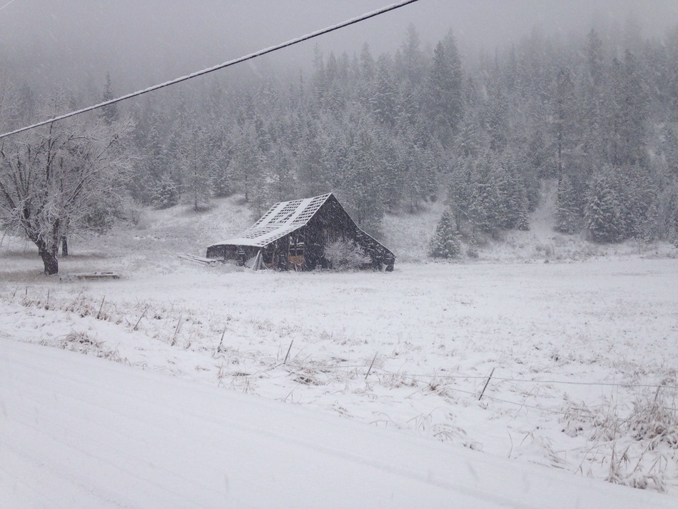
How about a couple of winter photos for you snow fans? These are off of wunderground weather site.
This one is from Kingston, Idaho.
And this was is from Eden, Utah

No major changes or adjustments to the forecast.

Winter cold is the only concern. Lows into the teens at night. Don’t forget about our outdoor friends.

The wild card tells you where the most uncertainty is in the current forecast.
Wild card in this forecast – no wild card through Thursday afternoon.

Obviously severe weather is not a concern. Cold weather over the coming days.
Can we expect severe thunderstorms over the next 24 to 48 hours? Remember that a severe thunderstorm is defined as a thunderstorm that produces 58 mph winds or higher, quarter size hail or larger, and/or a tornado.
Thunderstorm threat level is – ZERO


Will I need to take action?
No action required other than staying warm!

How much rain should this system produce over our region?
No rain in the forecast through Thursday afternoon.
Rainfall totals for Friday into Sunday should be in the 0.75″ – 1.50″ range. Quite a bit of rain may fall with this next system.
Let’s break this down a bit more
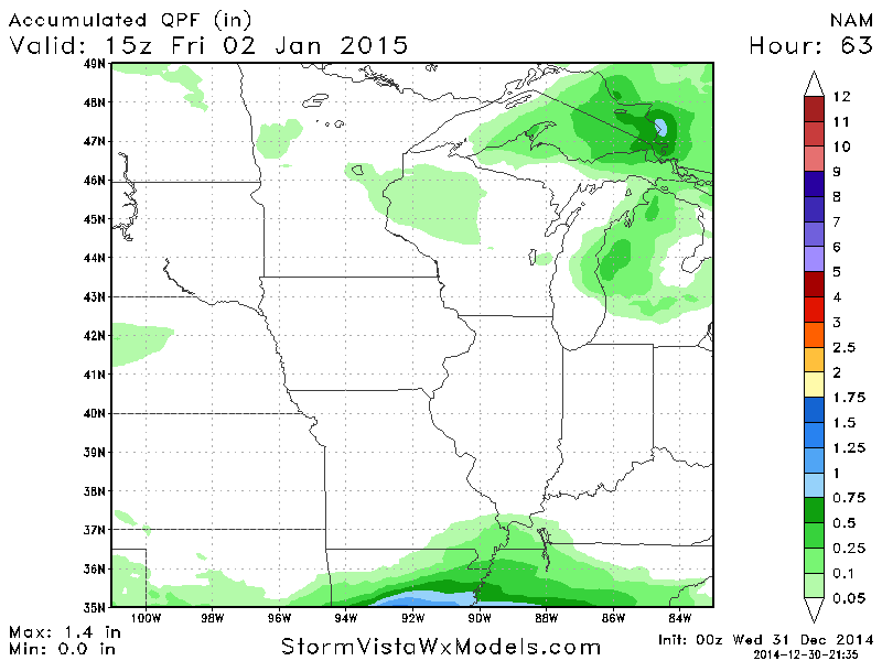
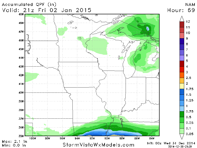
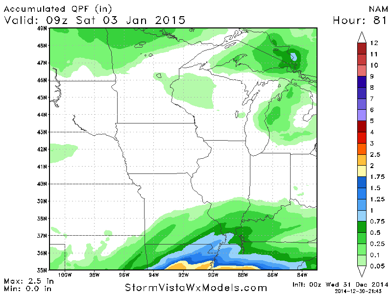
This is the NAM precipitation totals for Friday (from StormVista model data). I am breaking this down into 3-6 hour chunks as we push through Friday. You can see how the precipitation totals slowly increase from south to north. This is how precipitation will move into our region (from the southwest/south towards the north/northeast)
This first image is for 8 am on Friday morning
The second image is for 3 pm on Friday
The third image is for 9 pm on Friday
The last image is for 3 am on Saturday
These images tell you how much rain has fallen up to that point. Obviously the longer it rains the higher your totals will go. These images walk you through how the precipitation should develop and overspread the region on Friday. You can see that the bulk of the precipitation occurs as we move into the afternoon and evening hours on Friday.
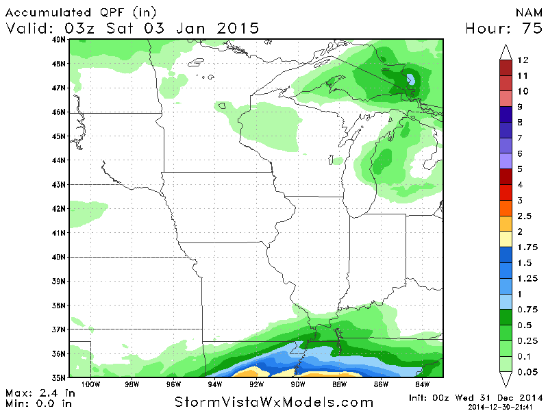
More precipitation falls after that time – I just stopped it during the wee early morning hours of Saturday. Additional rain will fall through Saturday.
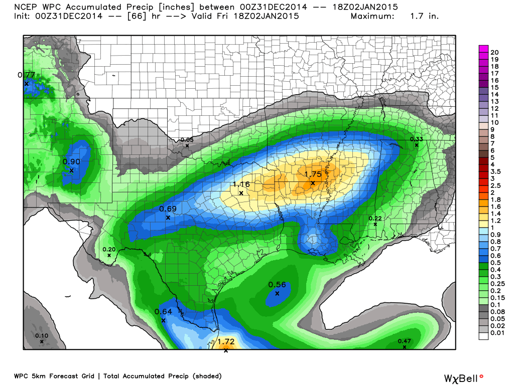
Another map for you…
This is the precipitation map through 12 pm on Friday. I am showing you this to give you an idea of just how light the precipitation could be on Thursday night and Friday morning. The data is indicating parts of the area will basically not even receive trace amounts.
The odds of small amounts of precipitation increase a bit as you go south and west. This is because the storm system is moving into our region from the southwest.
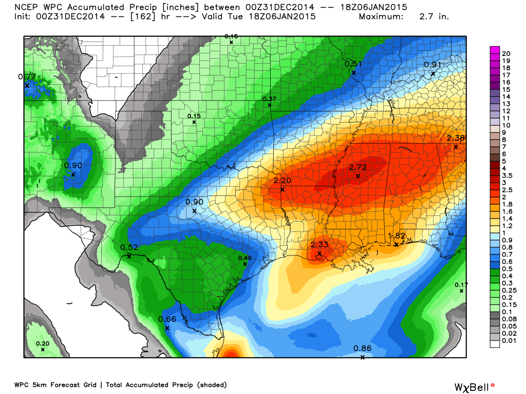
Now let’s take a look at the entire event from start to finish. You can see the precipitation totals increase quite a bit as we move through Friday, Saturday and Saturday night.
The scale is on the right side of the image.

The only winter weather that I am tracking would be the much talked about Thursday night and Friday morning precipitation chances. Confidence in this part of the forecast is low. Some of the data holds the bulk of the precipitation off to our southwest until later on Friday. This would give temperatures a chance to rise above freezing. If this happens then there will not be any problems.
IF (big IF) precipitation does develop on Thursday night and Friday morning then it would likely be a snow, sleet, and freezing rain mix.
Road temperatures will be cold on Thursday night and Friday morning. That means that anything that falls from the sky will stick on untreated roads. It only takes a hint of freezing rain to cause problems when roads a cold.

Colder air will return by Sunday into next week. Right now I am not tracking any significant winter weather events in the extended forecast. Keep checking back.
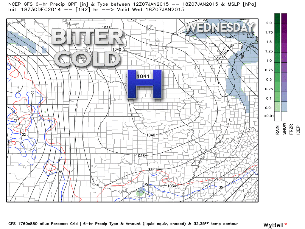
Another big high pressure center is forecast to move south into our region next week. This one will actually move towards our region (unlike the one this week that was further west).
Here is next Wednesday’s weather map from the GFS model. That big high will usher in more cold air.
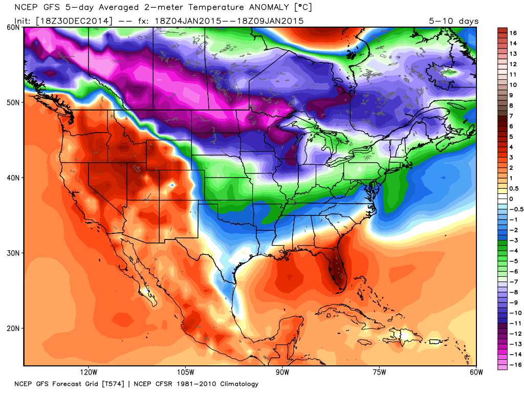
Here is the GFS weather computer model 5 day temperature anomaly map for January 4th through 9th.
What does this map show?
This map shows you how many degrees above or below normal temperatures will be for the 5 day period between January 4th and January 9th (Sunday through Friday of next week). You can see that some bitter cold air may move into our region next week. Again, this is a forecast map.
This cold shot will be in response to the big high pressure area (see map above) pushing southward into the Missouri and Ohio Valleys.
Those type of anomalies might mean temperatures way below zero over parts of northern Illinois and perhaps single digits as far south as part of our region. Still several days to monitor that cold shot.
Next precipitation event?
I am watching the January 7th through 10th time frame – perhaps centered around January 8th and 9th. LONG way off. But, right now I am watching that time frame.
Meteorological spring begins in two months! March 1st.
Radar

Regional Radar

Please visit your local National Weather Service Office by clicking here. The National Weather Service Office, for our region, is located in Paducah, Kentucky.

Here is the official 6-10 day and 8-14 day temperature and precipitation outlook. Check the date stamp at the top of each image (so you understand the time frame).
The forecast maps below are issued by the Weather Prediction Center (NOAA).


The latest 8-14 day temperature and precipitation outlook. Note the dates are at the top of the image. These maps DO NOT tell you how high or low temperatures or precipitation will be. They simply give you the probability as to whether temperatures or precipitation will be above or below normal.


Many of my graphics are from www.weatherbell.com – a great resource for weather data, model data, and more


This blog was inspired by ABC 33/40’s Alabama Weather Blog – view their blog
Current tower cam view from the Weather Observatory- Click here for all cameras.

Southern Illinois Weather Observatory

The Weather Observatory

Southern Illinois Weather Observatory
WSIL TV 3 has a number of tower cameras. Click here for their tower camera page & Illinois Road Conditions

Marion, Illinois
WPSD TV 6 has a number of tower cameras. Click here for their tower camera page & Kentucky Road Conditions & Kentucky Highway and Interstate Cameras

Downtown Paducah, Kentucky
Benton, Kentucky Tower Camera – Click here for full view

Benton, Kentucky

I24 Paducah, Kentucky

I24 Mile Point 9 – Paducah, KY

I24 – Mile Point 3 Paducah, Kentucky

You can sign up for my AWARE email by clicking here I typically send out AWARE emails before severe weather, winter storms, or other active weather situations. I do not email watches or warnings. The emails are a basic “heads up” concerning incoming weather conditions.