We have our first sponsor for the blog. Milner and Orr Funeral Home and Cremation Services located in Paducah, Kentucky and three other western Kentucky towns – at Milner and Orr they believe in families helping families.
![]()

This forecast update covers far southern Illinois, far southeast Missouri, and far western Kentucky. See the coverage map on the right side of the blog.
Tuesday – Quite a bit of sun this morning – then some clouds. It will be cold. High temperatures only in the 30’s. Winds from the north at 10-15 mph will make it feel even colder. 10% chance for a flurry.
Tuesday night – Increasing clouds. A small chance for a snow flurry. Cold. Low temperatures mostly in the teens. North winds at 5-10 mph. 10% chance for a flurry.
Wednesday – Quite a few clouds. A small chance for a flurry. It will feel like winter. High temperatures only in the 20’s. Northwest winds at 5-10 mph during the morning becoming more westerly in the afternoon. 10% chance for a flurry.
Wednesday night – A few clouds. It will be cold with overnight lows in the teens. Winds will become west/southwest at 5-10 mph.
Thursday – A mix of sun and clouds. Increasing clouds through the day. Chilly. High temperatures only in the 30’s. Winds will be from the southwest at 5-10 mph.
Widespread rain likely by Friday into Saturday night. A small window of opportunity late Thursday night and Friday morning for a wintry mix.
We may even hear some rumbles of thunder on Friday night or Saturday.

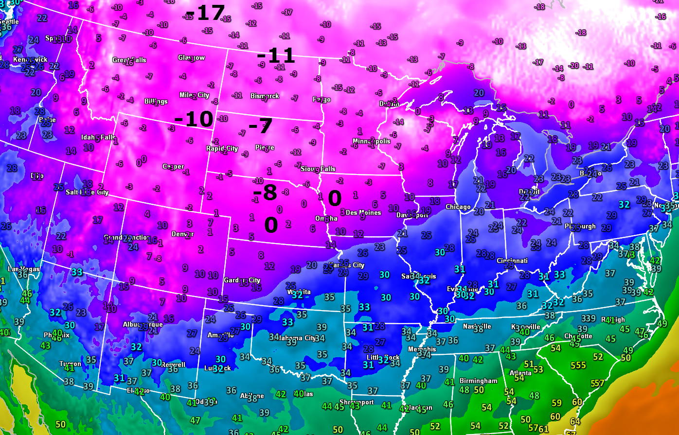
Current Temperatures Around The Local Area


An explanation of what is happening in the atmosphere over the coming days.
Good Tuesday morning, everyone! I hope you had a nice Monday. I know some of you are still off from work. I hope you are enjoying your winter break!
Speaking of winter – we have a lot of cold air to deal with over the next few days. We are not going to experience anything extreme, but it will definitely feel like winter.
Here were the temperatures last night at 11 pm. You can see that areas well to our northwest are shivering.
Click image for a better view.
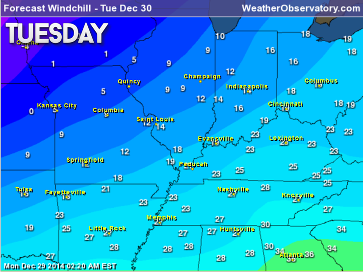
Wind chills today will be on the cold side. From time to time they will dip into the teens. Not the best outdoor day for the region.
A LARGE 1060 mb high pressure center will slide down into the Rockies today and tomorrow. This is a very strong area of high pressure – rather unusual to see one this large.
In the winter months an area of high pressure of this size sliding down from Canada can only mean one thing – COLD COLD COLD. Thankfully the high will not be centered over our region. The coldest air is typically centered underneath the area of high pressure.
You can see the area of high pressure on this forecast map for later today. The high is centered over the Central Plains.
The high will slowly slide southward on Wednesday. It is still centered well to our west. Thus, the coldest air will remain to our north and west.
High temperatures on Wednesday will likely struggle to get out of the 20’s. Overnight lows tonight and on Wednesday night will dip into the teens. A double blanket night.
There will be on and off periods of clouds over the coming days. Perhaps a mix of sun and clouds from time to time. With this type of air-mass one can’t completely rule out a snow flurry. Nothing major – perhaps one or two flakes in the air.
I do not foresee any travel problems for New Years Eve or New Years Day. I guess that is some good news!
With all of these cold temperatures I want to encourage you to remember our outdoor friends. Frozen water bowls and cold temperatures.
I am watching a large storm system for Friday into Sunday. See the extended discussion for details.

I lowered temperatures a bit through the period. It does appear that most areas will fall into the teens for overnight lows tonight and tomorrow night. Highs may not get out of the 20’s on Wednesday. Chilly air. Not extreme, but still cold.

Winter cold is the only concern. Lows into the teens at night. Don’t forget about our outdoor friends.

The wild card tells you where the most uncertainty is in the current forecast.
Wild card in this forecast – the wild card in this forecast is whether or not we see a few snow flurries with the cold air over the next few days. Nothing major – perhaps a flake or two in the air.

Obviously severe weather is not a concern. Cold weather over the coming days.
Can we expect severe thunderstorms over the next 24 to 48 hours? Remember that a severe thunderstorm is defined as a thunderstorm that produces 58 mph winds or higher, quarter size hail or larger, and/or a tornado.
Thunderstorm threat level is – ZERO


Will I need to take action?
No action required other than staying warm!

How much rain should this system produce over our region?
No rain in the forecast through Thursday afternoon.

I am tracking a storm system for later this week. We may see some light precipitation move into the area as soon as late Thursday night or on Friday. IF precipitation does move in on Thursday night or Friday morning then it could be a mixture of snow, sleet, and freezing rain. Very low confidence on how fast the precipitation moves into the area.
Temperatures will rise above freezing during the day on Friday. That will change everything over to rain.
There are a lot of different scenarios that could play out concerning the storm system later this week. See the extended discussion for more details.

The big ticket item in the extended forecast is a storm system that will pull out of the southwest United States on Thursday and Friday. This system will spread moisture back into our region starting as early as Thursday night and Friday morning.
The best chance of precipitation does not arrive until later on Friday into Saturday night. The window of opportunity for precipitation on Thursday night and Friday is a short one. Keep that in mind.
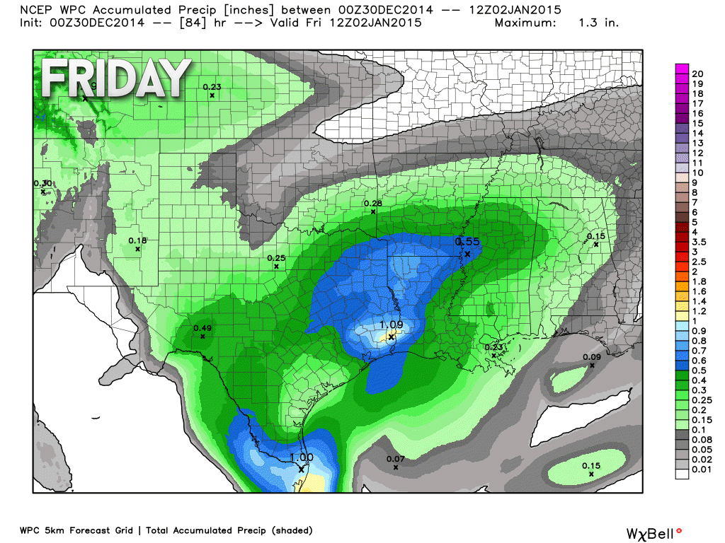
Here are a couple of maps showing you how much rain is forecast with this next system. The first map is for the Thursday night into Friday morning time frame. Very light amounts. That is good news because if precipitation does fall during that time period then it would likely be frozen.
Amounts on this map are less than 0.10″.
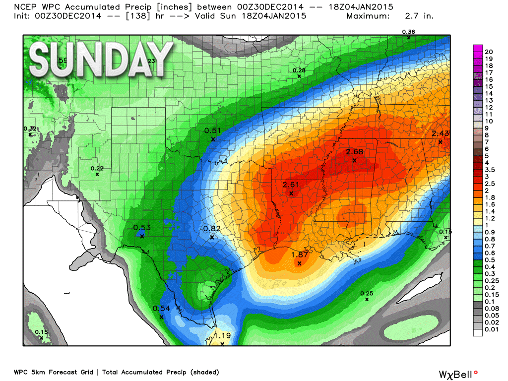
But, check out this map. This takes us through Sunday. Lot more precipitation falls between Friday morning and Sunday afternoon. Some places may pick up more than 1″ of rain.
A lot of questions remain concerning this system
1. Will the system be able to produce precipitation late Thursday night and Friday morning. There will be quite a bit of dry air aloft to overcome before precipitation reaches the ground.
2. If precipitation does fall during this time period then what form will it take
3. How quickly will the warm air push into our region on Friday
4. What will the track of the area of low pressure be. Will it track north of our area, over our area, or south of our area
Temperatures on Thursday night and Friday morning will be cold. Likely below freezing. IF precipitation can move in fast enough then it would begin as a wintry mix of snow, sleet, and freezing rain.
The good news is that temperatures are forecast to warm above freezing on Friday late morning into the afternoon hours. If a wintry mix does develop then it will not last long.
Warmer air should stick around through Friday night and Saturday. Quite a bit of rain may fall with this system.
The models have been back and forth on the exact track of the area of low pressure. From time to time the models shift the low further south. Some of the models have gone between the low moving to our north and the low moving to our south.
Where the low moves is important as far as how fast temperatures warm on Friday and how much rain falls with the system.
It is still a bit early to know for sure where the low will track.
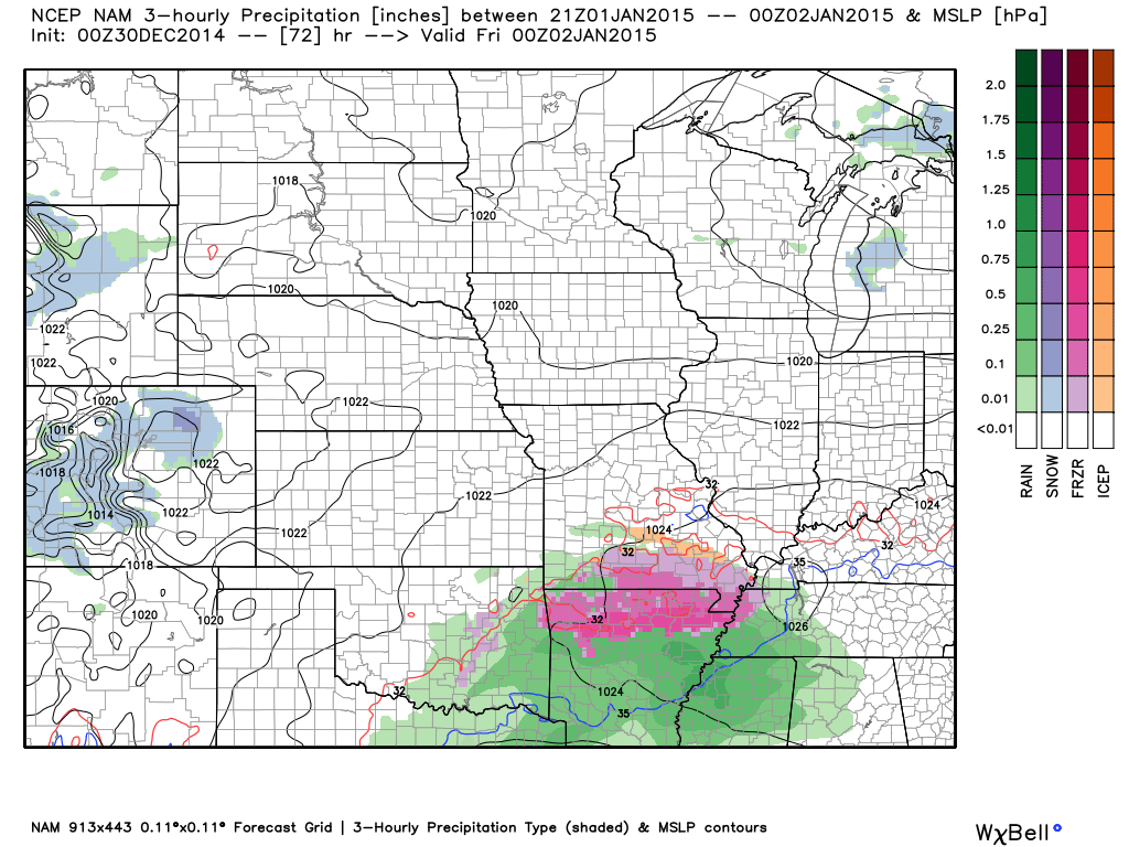
The high resolution NAM model is trying to bring precipitation into our local counties as early as Thursday evening. This seems a bit suspect to me. There will be quite a bit of dry air to overcome before precipitation even reaches the ground. So, this model seems overdone and overzealous in how fast the precipitation moves into our region.
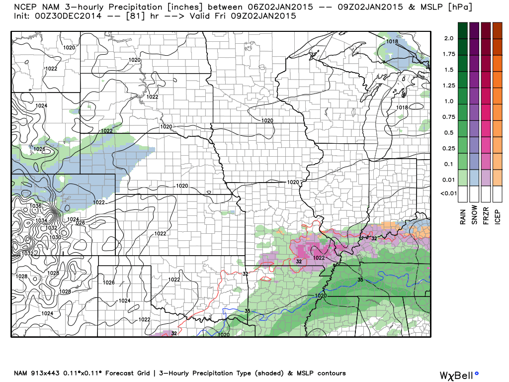
The NAM model shows precipitation continuing on Friday morning at 4 am. It continues to show a wintry mix at that time. Again, perhaps this is overdone. Although, by Friday morning the precipitation chances would be at least a little bit higher than say 12 hours earlier.
The GFS model is a bit slower in bringing precipitation into our area. It holds precipitation back until later on Friday morning.
It does show quite a bit of rain on Saturday (late morning and early afternoon). You can see the low is still to our southwest at this time. All of that green represents precipitation (rain).
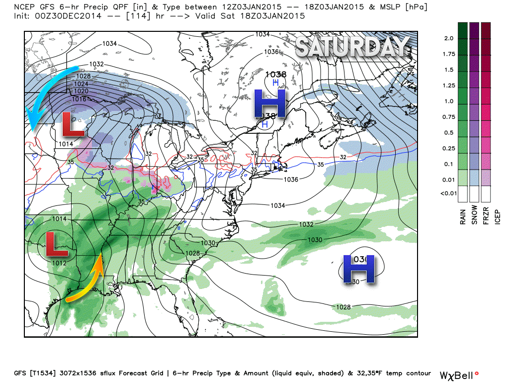
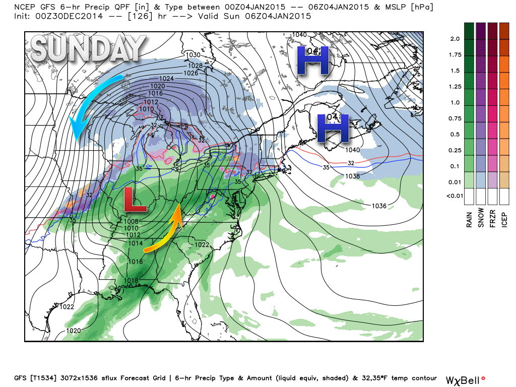
On Saturday night (11 pm) the low is moving over our local area. That keeps us in the warm sector of the storm. You can see the area of low pressure is wrapping up. Warm air advancing northward on the east side of the low. Cold air wrapping in behind the storm.
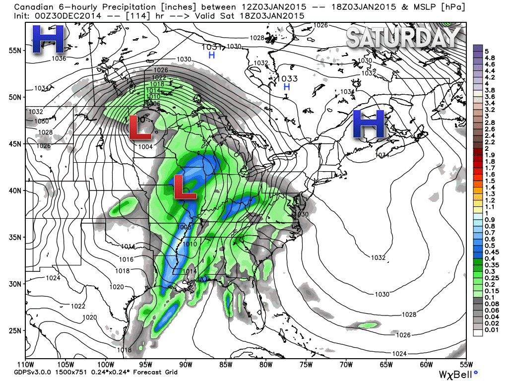
The Canadian model also takes the storm pretty far north. The Canadian model also keeps us mostly rain.
This map is for Saturday late morning. You can see the low centered to our north. Lots of rain in our local area.
Radar

Regional Radar

Please visit your local National Weather Service Office by clicking here. The National Weather Service Office, for our region, is located in Paducah, Kentucky.

Here is the official 6-10 day and 8-14 day temperature and precipitation outlook. Check the date stamp at the top of each image (so you understand the time frame).
The forecast maps below are issued by the Weather Prediction Center (NOAA).


The latest 8-14 day temperature and precipitation outlook. Note the dates are at the top of the image. These maps DO NOT tell you how high or low temperatures or precipitation will be. They simply give you the probability as to whether temperatures or precipitation will be above or below normal.


Many of my graphics are from www.weatherbell.com – a great resource for weather data, model data, and more


This blog was inspired by ABC 33/40’s Alabama Weather Blog – view their blog
Current tower cam view from the Weather Observatory- Click here for all cameras.

Southern Illinois Weather Observatory

The Weather Observatory

Southern Illinois Weather Observatory
WSIL TV 3 has a number of tower cameras. Click here for their tower camera page & Illinois Road Conditions

Marion, Illinois
WPSD TV 6 has a number of tower cameras. Click here for their tower camera page & Kentucky Road Conditions & Kentucky Highway and Interstate Cameras

Downtown Paducah, Kentucky
Benton, Kentucky Tower Camera – Click here for full view

Benton, Kentucky

I24 Paducah, Kentucky

I24 Mile Point 9 – Paducah, KY

I24 – Mile Point 3 Paducah, Kentucky

You can sign up for my AWARE email by clicking here I typically send out AWARE emails before severe weather, winter storms, or other active weather situations. I do not email watches or warnings. The emails are a basic “heads up” concerning incoming weather conditions.