We have our first sponsor for the blog. Milner and Orr Funeral Home and Cremation Services located in Paducah, Kentucky and three other western Kentucky towns – at Milner and Orr they believe in families helping families.
![]()

This forecast update covers far southern Illinois, far southeast Missouri, and far western Kentucky. See the coverage map on the right side of the blog.
Thursday – A mix of sun and clouds. Increasing clouds during the afternoon hours. High temperatures only in the 30’s. Southwest winds at 10 mph.
Thursday night – Cloudy with a chance for light freezing rain, sleet, and a few snowflakes. Otherwise, mostly cloudy. Low temperatures will be in the upper 20’s and lower 30’s. Southwest winds at 10 mph. Keep in mind that it only takes a hint of freezing rain to cause problems when road surfaces are cold.
Friday – Cloudy. A chance for a wintry mix during the early morning hours. Otherwise, a chance for showers. High temperatures will be in the 30’s. Southwest winds at 5-10 mph. Winds becoming east/southeast at 5 mph.
Friday night – Cloudy with rain likely. Temperatures holding steady or even rising. Lows will be in the 30’s. East winds at 10-15 mph.
Saturday – Rain likely and even a few thunderstorms. There will be a wide range of temperatures from northwest to southeast across the area. Temperatures over the far northwest counties may be in the 30’s and 50’s over parts of far southern Illinois and western Kentucky. East/southeast winds at 10 mph. Chance of precipitation will be 100%

Current Temperatures Around The Local Area


An explanation of what is happening in the atmosphere over the coming days.
Happy New Year, everyone.
Our weather will be dominated by high pressure today, but that will soon change as an area of low pressure develops to our southwest. This low will move towards our region on Friday into Saturday night.
Winds will turn out of the southwest today. That will start to spread moisture into the cold air mass currently situated over our area.
Some light freezing rain and sleet may develop tonight into early Friday morning.
The precipitation should remain on the light side tonight into early Friday morning.
Road temperatures are cold. IF freezing rain or drizzle were to develop then it could cause problems on roadways. Keep this in mind. It really does not take much of a wintry mix to cause problems when road temperatures are cold.
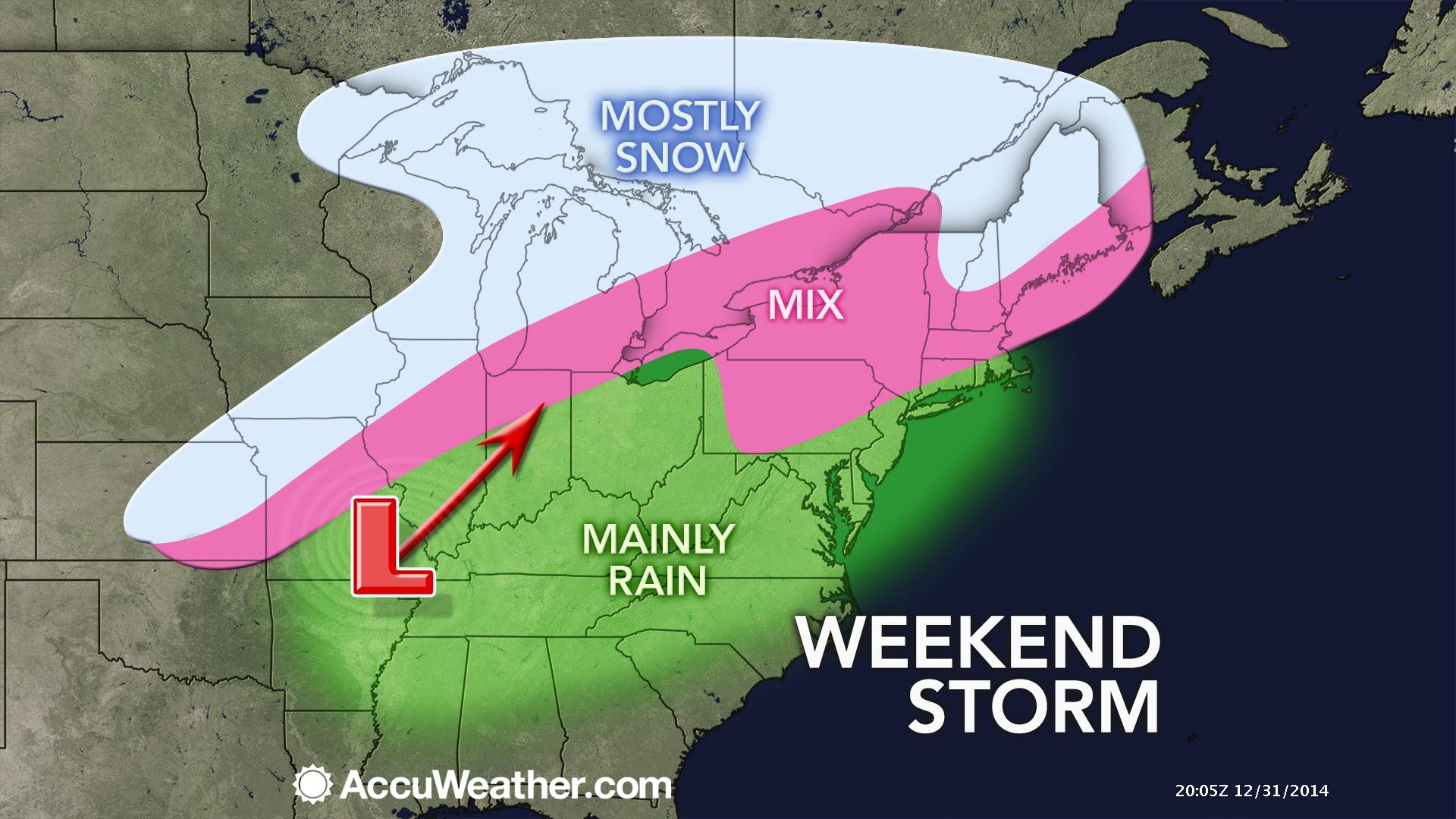
The bigger story will be widespread rain that will develop from south/southwest across our region later on Friday and Friday night. This rain will continue into Saturday and Saturday night. Locally heavy rain is possible. I can’t rule out a few thunderstorms! Imagine that! First of January and we are talking about a few thunderstorms. Oh well, snow lovers you just can’t seem to win.
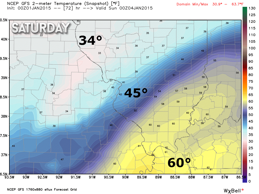
There will be a wide range of temperatures across the region over the coming days. As the low pushes over our region it will draw up warm and moist air from the Gulf of Mexico. That means that temperatures could rise into the 50’s and maybe briefly into the 60’s over parts of far southern Illinois and western Kentucky. This would most likely occur on Saturday.
Where these warmer temperatures develop will depend on the exact track of the area of low pressure. The warmer air will spread further north if the low tracks further north. If the low tracks further south than anticipated then the colder air will be a bit further south.
Let me show you some temperature maps from the models. I want you to see the sharp gradient over the region. This is for late Saturday afternoon. Nice temperature gradient across the region!
Again, this is partly dependent on the exact track of that area of low pressure. But, you at least get the general idea that there will be quite the spread across our region.

No major changes. Still wrestling with the precipitation chances later tonight and early Friday morning. Light precipitation could move into the region while temperatures are still below freezing. If that occurs then use caution on area roadways.

The main concern for this forecast period will be the chance for freezing rain and sleet later tonight and Friday morning. There is a window of opportunity for some frozen precipitation before temperatures rise above freezing on Friday.
Right now the overall probabilities for precipitation are on the low side. The problem is that road temperatures are cold. That means IF precipitation does fall then it could cause some slick spots. Use care.

The wild card tells you where the most uncertainty is in the current forecast.
Wild card in this forecast – the wild card in this forecast will be the frozen precipitation potential for later this evening into Friday morning. The second wild card will be whether or not a few thunderstorms occur on Saturday

Can we expect severe thunderstorms over the next 24 to 48 hours? Remember that a severe thunderstorm is defined as a thunderstorm that produces 58 mph winds or higher, quarter size hail or larger, and/or a tornado.
Thunderstorm threat level is ZERO through Friday. We may have a few thunderstorms on Saturday.


Will I need to take action?
Use care tonight if frozen precipitation does spread into the area from the southwest. This could cause some slick spots.

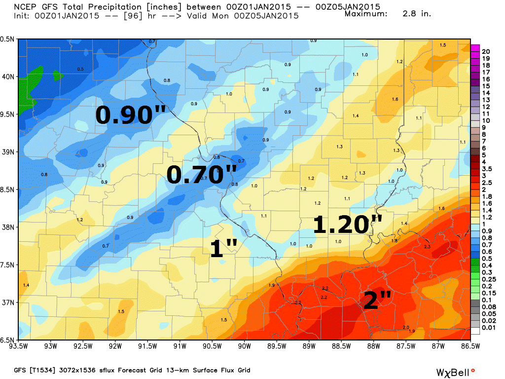
How much rain should this system produce over our region?
Quite a bit of rain over the coming days.
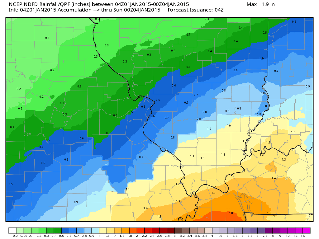
Let’s compare rainfall forecasts – they do vary a little bit. All of the data does place the heaviest totals over parts of western Kentucky.
Here is the GFS model rainfall forecast for Thursday night through Sunday.
Here is the official National Weather Service rainfall forecast. Again, you can see that the NWS rainfall forecast totals agree with the GFS model on the placement of the heaviest totals.
These totals are for Thursday night through Sunday. The bulk of this will fall Friday night into Saturday night.

We will have at least a chance for some light freezing rain or sleet tonight. Can’t rule out a few snowflakes. Temperatures will warm above freezing on Friday (late morning and afternoon).
The precipitation comes to an end on Sunday and may end as a few snowflakes. No accumulation expected.
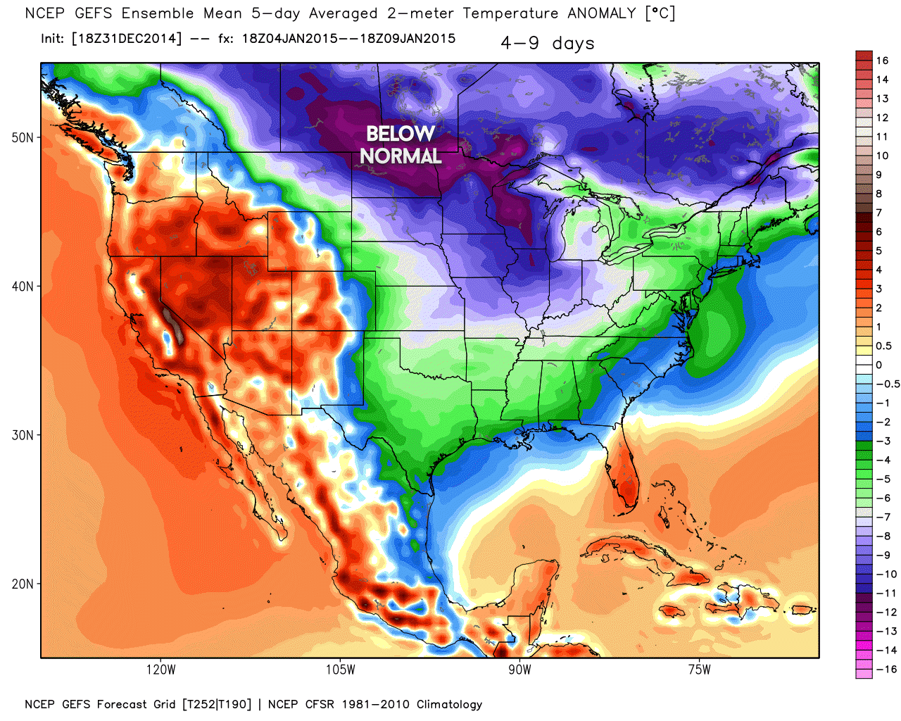
A strong blast of cold air arrives next week and a few flurries may accompany the cold air. Perhaps another system to monitor towards the end of next week.

Another cold blast next week. Next weeks temperatures may be colder than this week. The area of high pressure coming down from Canada will actually move over our region this time around. This weeks high pressure was centered well to our west.
We may see some flurries with the cold air next week. Right now I do not see a snowstorm in the cards. Once again – sorry snow fans. I will keep an eye on late next week. Perhaps another precipitation event.
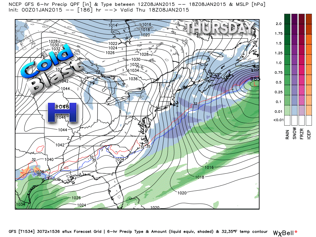
Here is what the GFS model is showing for the next area of high pressure (associated with cold air)
These high pressure centers typically move down from Canada during the winter months. Arctic air is normally associated with them. The coldest temperatures are normally found directly under the center of the high pressure. This map is for next Thursday. You can see a strong 1045_mb area of high pressure.
Image is from weatherbell.com
Here is the anomaly map for next week. This map shows you how many degrees below normal temperatures will average. That is a pretty good blast of cold air. Temperatures will be well below normal for most of next week.

We have regional radars and local city radars – if a radar does not seem to be updating then try another one. Occasional browsers need their cache cleared. You may also try restarting your browser. That usually fixes the problem. Occasionally we do have a radar go down. That is why I have duplicates. Thus, if one fails then try another one.
If you have any problems then please send me an email beaudodson@usawx.com
WEATHER RADAR PAGE – Click here —
We also have a new national interactive radar – you can view that radar by clicking here.
Local interactive city radars include St Louis, Mt Vernon, Evansville, Poplar Bluff, Cape Girardeau, Marion, Paducah, Hopkinsville, Memphis, Nashville, Dyersburg, and all of eastern Kentucky – these are interactive radars. Local city radars – click here
NOTE: Occasionally you will see ground clutter on the radar (these are false echoes). Normally they show up close to the radar sites – including Paducah.

Regional Radar – Click on radar to take you our full radar page.


Regional Radar

Live Lightning Data – zoom and pan: Click here
Live Lightning Data with sound (click the sound button on the left side of the page): Click here

Please visit your local National Weather Service Office by clicking here. The National Weather Service Office, for our region, is located in Paducah, Kentucky.

Here is the official 6-10 day and 8-14 day temperature and precipitation outlook. Check the date stamp at the top of each image (so you understand the time frame).
The forecast maps below are issued by the Weather Prediction Center (NOAA).


The latest 8-14 day temperature and precipitation outlook. Note the dates are at the top of the image. These maps DO NOT tell you how high or low temperatures or precipitation will be. They simply give you the probability as to whether temperatures or precipitation will be above or below normal.


Many of my graphics are from www.weatherbell.com – a great resource for weather data, model data, and more


This blog was inspired by ABC 33/40’s Alabama Weather Blog – view their blog
Current tower cam view from the Weather Observatory- Click here for all cameras.

Southern Illinois Weather Observatory

The Weather Observatory

Southern Illinois Weather Observatory
WSIL TV 3 has a number of tower cameras. Click here for their tower camera page & Illinois Road Conditions

Marion, Illinois
WPSD TV 6 has a number of tower cameras. Click here for their tower camera page & Kentucky Road Conditions & Kentucky Highway and Interstate Cameras

Downtown Paducah, Kentucky
Benton, Kentucky Tower Camera – Click here for full view

Benton, Kentucky

I24 Paducah, Kentucky

I24 Mile Point 9 – Paducah, KY

I24 – Mile Point 3 Paducah, Kentucky

You can sign up for my AWARE email by clicking here I typically send out AWARE emails before severe weather, winter storms, or other active weather situations. I do not email watches or warnings. The emails are a basic “heads up” concerning incoming weather conditions.