We have some great sponsors for the Weather Talk Blog. Please let our sponsors know that you appreciate their support for the Weather Talk Blog.
Milner and Orr Funeral Home and Cremation Services located in Paducah, Kentucky and three other western Kentucky towns – at Milner and Orr they believe in families helping families. You can find Milner and Orr on Facebook, as well.
![]()
.

For all of your families eye care needs. Visit their web-site here. Or, you can also visit their Facebook page.
.

Best at Enabling Body Shop Profitability since 1996. Located In Paducah Kentucky and Evansville Indiana; serving all customers in between. They provide Customer Service, along with all the tools necessary for body shops to remain educated and competitive. Click the logo above for their main web-site. You can find McClintock Preferred Finishes on Facebook, as well

Expressway Carwash and Express Lube are a locally owned and operated full service Carwash and Lube established in 1987. We have been proudly serving the community for 29 years now at our Park Avenue location and 20 years at our Southside location. We have been lucky enough to partner with Sidecar Deli in 2015, which allows us to provide our customers with not only quality service, but quality food as well. . If you haven’t already, be sure to make Expressway your one stop shop, with our carwash, lube and deli. For hours of operation and pricing visit www.expresswashlube.com or Expressway Carwash on Facebook.

TORNADO SHELTERS! Endrizzi’s Storm Shelters – For more information click here. Endrizzi Contracting and Landscaping can be found on Facebook, as well – click here
I have launched the new weather texting service! I could use your help. Be sure and sign up and fully support all of the weather data you see each day.
This is a monthly subscription service. Supporting this helps support everything else. The cost is $3 a month for one phone, $5 a month for three phones, and $10 a month for seven phones.
For more information visit BeauDodsonWeather.com
Or directly sign up at Weathertalk.com


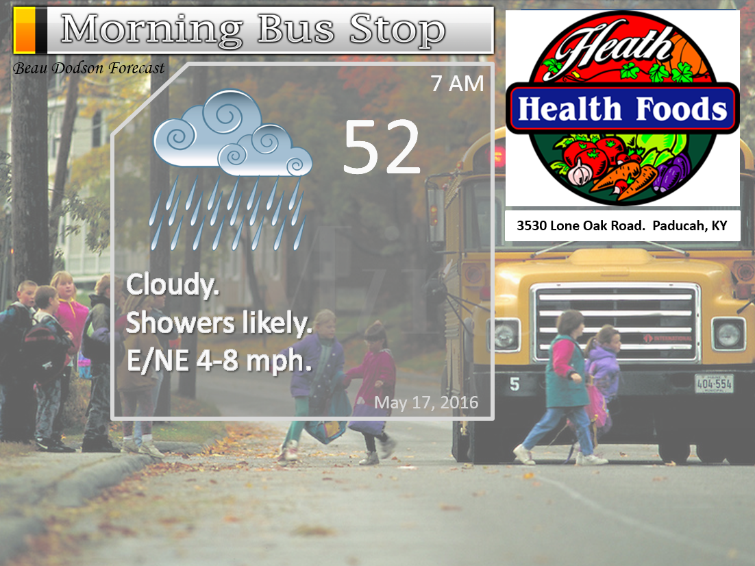
This forecast update covers far southern Illinois, far southeast Missouri, and far western Kentucky. See the coverage map on the right side of the blog.
Remember that weather evolves. Check back frequently for updates, especially during active weather.

Monday Night – Cloudy. A chance for showers and perhaps a few non-severe thunderstorms. Heaviest rain totals will be over the northern counties in the region. Northern parts of southeast Missouri and northern parts of southern Illinois.
Temperatures: Lows in the 48-54 degree range
Winds: Winds east and southeast at 5-10 mph.
What is the chance for precipitation? 60%
Coverage of precipitation: Scattered to numerous
My confidence in this part of the forecast verifying is High
Should I be concerned about snow or ice? No
Should I cancel my outdoor plans? Maybe have a plan B
Is severe weather expected? Unlikely
What impact is expected? Wet roadways. Lightning.
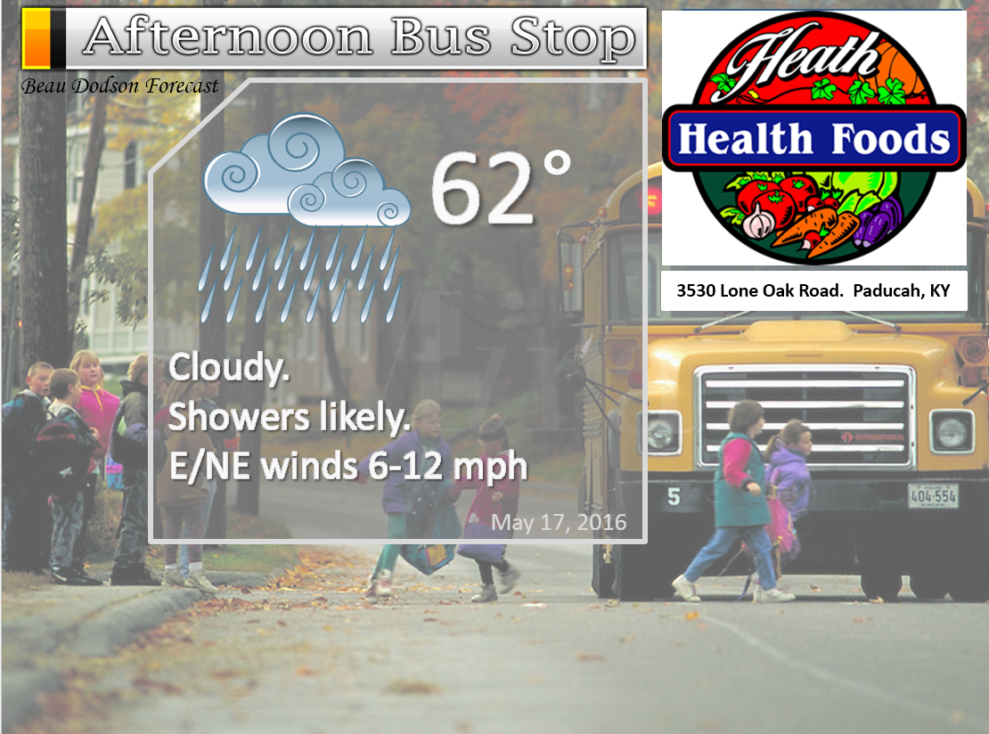
Tuesday – Mostly cloudy and cool for part of the area. Showers. Thunderstorms possible. Non-severe. Heaviest rain totals will be over the northern counties in the region. Northern parts of southeast Missouri and northern parts of southern Illinois.
Temperatures: High temperatures in the 54-58 degree range for most of southern Illinois and southeast Missouri. The Missouri Bootheel into the Kentucky/Tennessee line area might reach the 60s. This will depend on cloud cover. Keep that in mind.
Winds: East and northeast winds at 6-12 mph with gusts to 18
What is the chance for precipitation? 60%-70%
Coverage of precipitation? Numerous
My confidence in this part of the forecast verifying is High
Should I be concerned about snow or ice? No
Should I cancel my outdoor plans? Maybe have a plan B
Is severe weather expected? No
What impact is expected? Wet roadways. Lightning.
Tuesday Night – Cloudy. A few showers possible.
Temperatures: Lows in the 48-54 degree range
Winds: Winds east/northeast at 5-10 mph. Gusts to 12 mph.
What is the chance for precipitation? 40%. Rain should come to an end on Tuesday night.
Coverage of precipitation: Scattered
My confidence in this part of the forecast verifying is High
Should I be concerned about snow or ice? No
Should I cancel my outdoor plans? No, but monitor radars
Is severe weather expected? No
What impact is expected? Wet roadways. Small chance for lightning before 7 pm.
Rainfall totals for this whole event should range from 1″+ over our northern counties to 0.30″-0.75″ over our southern counties. Less south vs north.
Wednesday – A mix of sun and clouds. Cool.
Temperatures: High temperatures in the 66-72 degree range.
Winds: Northeast and east winds at 7-14 mph with gusts to 20-25 mph.
What is the chance for precipitation? 10%
Coverage of precipitation? None
My confidence in this part of the forecast verifying is High
Should I be concerned about snow or ice? No
Should I cancel my outdoor plans? No
Is severe weather expected? No
What impact is expected? None
Wednesday Night – Partly cloudy. Cool.
Temperatures: Lows in the 48-54 degree range
Winds: Winds east and northeast at 5-10 mph. Gusts to 12 mph.
What is the chance for precipitation? 0%
Coverage of precipitation: None
My confidence in this part of the forecast verifying is High
Should I be concerned about snow or ice? No
Should I cancel my outdoor plans? No
Is severe weather expected? No
What impact is expected? None
Thursday – Partly sunny.
Temperatures: High temperatures in the 68-74 degree range.
Winds: East winds at 6-12 mph. Gusts to 20 mph
What is the chance for precipitation? 0%
Coverage of precipitation? None
My confidence in this part of the forecast verifying is High
Should I be concerned about snow or ice? No
Should I cancel my outdoor plans? No
Is severe weather expected? No
What impact is expected? None
Thursday Night – Partly cloudy. A chance for a shower or thunderstorm.
Temperatures: Lows in the 52-56 degree range
Winds: Winds east and southeast at 5-10 mph.
What is the chance for precipitation? 20% before midnight. Increasing to 40%-50% after midnight.
Coverage of precipitation: Increasing coverage possible overnight
My confidence in this part of the forecast verifying is Medium
Should I be concerned about snow or ice? No
Should I cancel my outdoor plans? No, but monitor radars
Is severe weather expected? Unlikely
What impact is expected? Wet roadways and lightning.
Friday – Mostly cloudy. A shower or thunderstorm possible.
Temperatures: High temperatures in the 66-72 degree range.
Winds: Variable winds at 6-12 mph with gusts to 18
What is the chance for precipitation? 40%-50%
Coverage of precipitation? Scattered
My confidence in this part of the forecast verifying is Medium
Should I be concerned about snow or ice? No
Should I cancel my outdoor plans? Might want to have a plan B.
Is severe weather expected? Monitor
What impact is expected? Lightning. Wet roadways.
Friday Night – Partly to mostly cloudy. Some linger showers possible.
Temperatures: Lows in the 52-56 degree range
Winds: Winds north and northeast at 5-10 mph. Winds variable in direction at times.
What is the chance for precipitation? 40%
Coverage of precipitation: Scattered
My confidence in this part of the forecast verifying is Medium
Should I be concerned about snow or ice? No
Should I cancel my outdoor plans? Monitor
Is severe weather expected? Monitor
What impact is expected? Lightning and wet roadways.
Saturday – Partly cloudy.
Temperatures: High temperatures in the 70-75 degree range.
Winds: North and northeast winds at 6-12 mph with gusts to 15
What is the chance for precipitation? 20% (monitor updates)
Coverage of precipitation? Scattered (but monitor for changes)
My confidence in this part of the forecast verifying is Low
Should I be concerned about snow or ice? No
Should I cancel my outdoor plans? No, but monitor updates.
Is severe weather expected? No
What impact is expected?
Saturday Night – Mostly clear.
Temperatures: Lows in the 55-60 degree range
Winds: Winds north and northeast at 5-10 mph.
What is the chance for precipitation? 0%
Coverage of precipitation: None
My confidence in this part of the forecast verifying is Medium
Should I be concerned about snow or ice? No
Should I cancel my outdoor plans? No
Is severe weather expected? No
What impact is expected? None
Sunday – Mostly sunny.
Temperatures: High temperatures in the 72-76 degree range.
Winds: Northeast and east winds at 10 mph with gusts to 16 mph
What is the chance for precipitation? 0%
Coverage of precipitation?
My confidence in this part of the forecast verifying is Medium
Should I be concerned about snow or ice? No
Should I cancel my outdoor plans? No
Is severe weather expected?
What impact is expected?
Sunday Night – Mostly clear.
Temperatures: Lows in the 50-55 degree range
Winds: Winds south and southeast at 5-10 mph.
What is the chance for precipitation? 0%
Coverage of precipitation: None
My confidence in this part of the forecast verifying is High
Should I be concerned about snow or ice? No
Should I cancel my outdoor plans? No
Is severe weather expected? No
What impact is expected? None
Monday – Mostly sunny.
Temperatures: High temperatures in the 75-80 degree range.
Winds: South and southeast winds at 5-10 mph with gusts to 12 mph
What is the chance for precipitation? 0%
Coverage of precipitation? None
My confidence in this part of the forecast verifying is Medium
Should I be concerned about snow or ice? No
Should I cancel my outdoor plans? No
Is severe weather expected? No
What impact is expected? None
Monday Night – Partly cloudy.
Temperatures: Lows in the 58-64 degree range
Winds: Winds south and southeast at 5-10 mph.
What is the chance for precipitation? 0%
Coverage of precipitation: None
My confidence in this part of the forecast verifying is Low
Should I be concerned about snow or ice? No
Should I cancel my outdoor plans? No
Is severe weather expected? No
What impact is expected? None
Tuesday – Partly sunny. Warm. A thunderstorm possible.
Temperatures: High temperatures in the 78-84 degree range.
Winds: South and southwest winds at 5-10 mph with gusts to 18 mph
What is the chance for precipitation? 20%
Coverage of precipitation? Isolated
My confidence in this part of the forecast verifying is Low
Should I be concerned about snow or ice? No
Should I cancel my outdoor plans? No
Is severe weather expected? Unlikely
What impact is expected? Wet roadways and lightning.
Tuesday Night – Partly cloudy. A thunderstorm possible.
Temperatures: Lows in the 60-64 degree range
Winds: Winds south and southwest at 5-10 mph.
What is the chance for precipitation? 20%
Coverage of precipitation: Isolated
My confidence in this part of the forecast verifying is Low
Should I be concerned about snow or ice? No
Should I cancel my outdoor plans? No
Is severe weather expected? Unlikely
What impact is expected? Wet roadways and lightning.
Wednesday – Partly sunny. Warm.
Temperatures: High temperatures in the 80-84 degree range.
Winds: South and southwest winds at 6-12 mph
What is the chance for precipitation? 0%
Coverage of precipitation? None
My confidence in this part of the forecast verifying is Low
Should I be concerned about snow or ice? No
Should I cancel my outdoor plans? No
Is severe weather expected?
What impact is expected?
Wednesday Night – Partly cloudy.
Temperatures: Lows in the 60-64 degree range
Winds: Winds south and southwest at 5-10 mph.
What is the chance for precipitation? 0%
Coverage of precipitation: Isolated
My confidence in this part of the forecast verifying is Low
Should I be concerned about snow or ice? No
Should I cancel my outdoor plans? No
Is severe weather expected?
What impact is expected?
The School Bus Stop Forecast is sponsored by Heath Health and Wellness. Located next to Crowell Pools in Lone Oak, Kentucky.
Visit their web-site here. And. visit Heath Health Foods on Facebook!

The School Bus Stop Forecast is sponsored by Heath Health and Wellness. Located next to Crowell Pools in Lone Oak, Kentucky.
Visit their web-site here. And. visit Heath Health Foods on Facebook!
Heath Health Foods is a locally owned and operated retail health and wellness store. Since opening in February 2006; the store has continued to grow as a ministry with an expanding inventory which also offers wellness appointments and services along with educational opportunities. Visit their web-site here. And. visit Heath Health Foods on Facebook!
The weekend forecast is sponsored by Farmer and Company Real Estate.

The weekend forecast is sponsored by Farmer and Company Real Estate. Click here to visit their site.

Don’t forget to check out the Southern Illinois Weather Observatory web-site for weather maps, tower cams, scanner feeds, radars, and much more! Click here

An explanation of what is happening in the atmosphere over the coming days…
- Rain
- Drier Wednesday and Thursday
- More rain possible Friday into Saturday
I am loving the quiet weather. It is a bit on the cool side. I will agree with you on that topic. Especially cool for the middle of May. But, the cooler weather typically means less severe weather. But, not less rain. A trade off of sorts?
A weather system moving through our region will produce numerous showers over the next 24 hours. The heaviest rain totals are forecast to fall over the northern parts of southeast Missouri and southern Illinois (see rainfall graphic further down on the page). Those areas may experience more than 1″ of precipitation. Elsewhere, we will also have numerous showers and thunderstorms. Rainfall totals should range from 0.40″-0.80″ across much of the region. Guidance shows some areas actually receiving less than those totals.
I am not anticipating any severe thunderstorms or tornadoes.

The rain will come to an end on Tuesday night and Wednesday morning. This should leave us dry on Wednesday and Thursday. Another weather system approaches on Thursday night into Friday night. Expect an area of low pressure to develop to our west. This system will approach our region on Thursday night. Showers and thunderstorms should develop across the region during this time period. Some of the rain could be locally heavy. The severe weather threat looks small. Monitor updates. There may be adjustments to the Friday forecast.
Saturday and Sunday might end up mostly dry. However, there is little agreement in the numerical guidance. That means to monitor updates. If the area of low pressure is slow to move off to the east then shower and thunderstorm chances could very well linger into Saturday. If you have outdoor plans on Saturday then monitor updates.
I do not see any significant signs of severe weather in the charts. A very strange year. It is not normal to have such a lack of severe weather in May. We have had our fair share, but overall it has been unusually quiet. Let’s enjoy it.
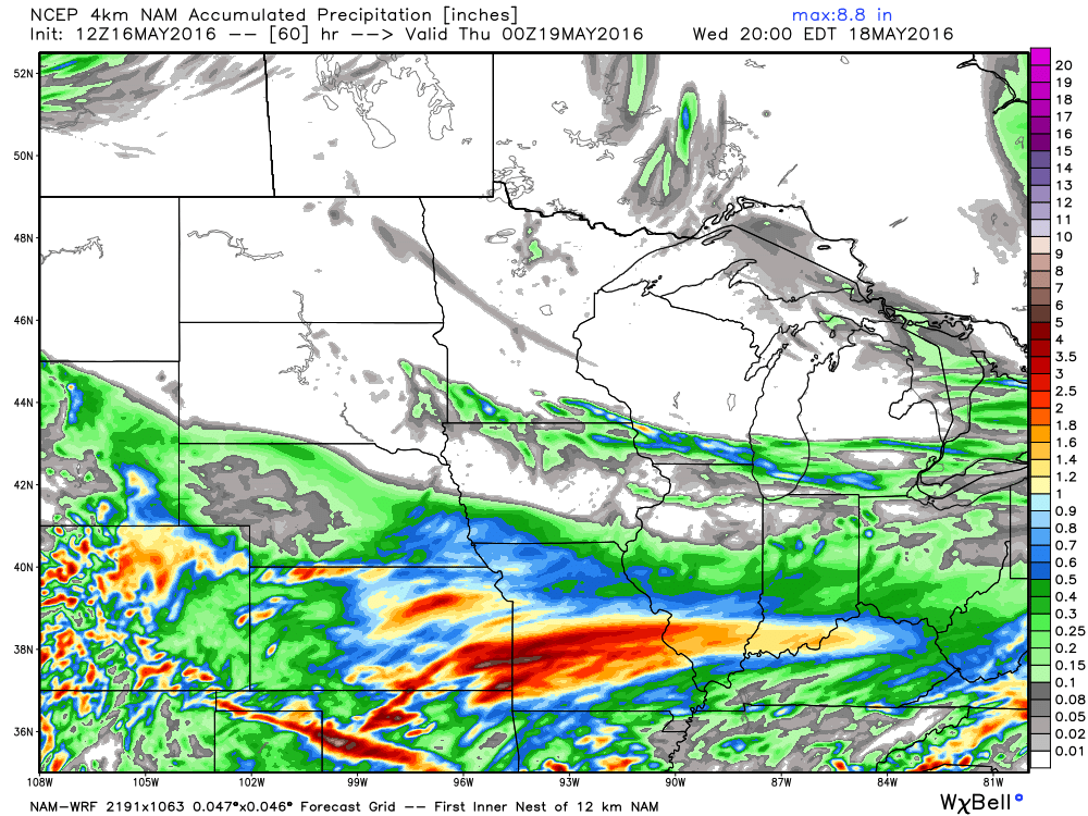
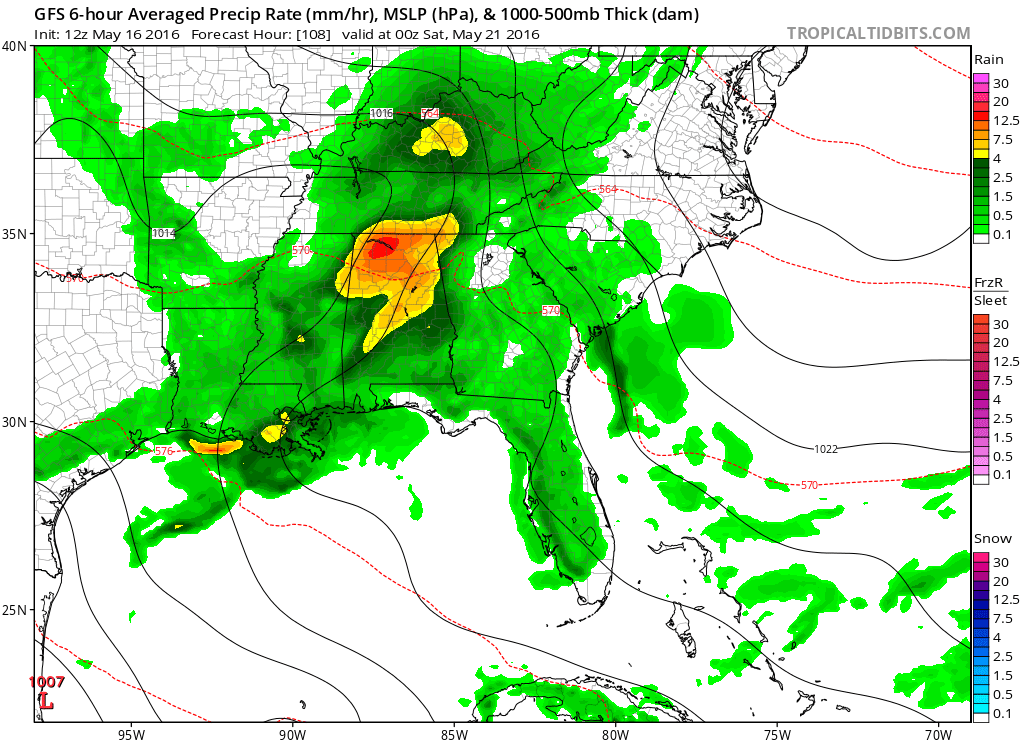
There will be a significant spread of rainfall totals for our region over the next two days. Check out the WRF guidance. Heaviest totals are likely to be over our northern counties.
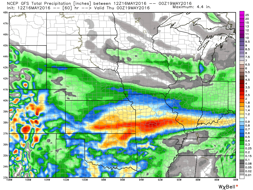
The GFS model guidance shows even less rain over parts of the region. Image is from WeatherBell. Com
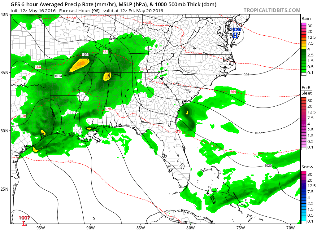
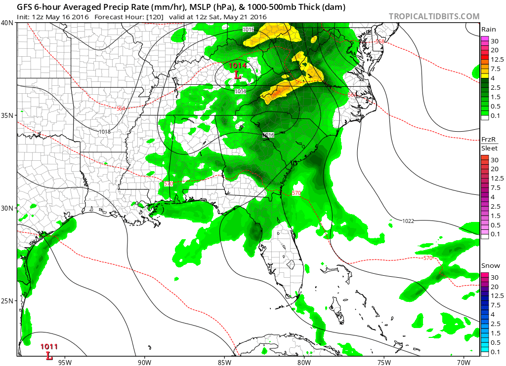
Here is the GFS model guidance for Saturday. I wanted to show you what it is indicating. Saturday’s forecast will depend on how fast the area of low pressure pushes out of the region.
This image below is for Friday morning at 7 am. Green represents rain showers.
Then on Friday evening
and then on Saturday morning at 7 am. The GFS has most of the precipitation moving off to the east.

We have regional radars and local city radars – if a radar does not seem to be updating then try another one. Occasional browsers need their cache cleared. You may also try restarting your browser. That usually fixes the problem. Occasionally we do have a radar go down. That is why I have duplicates. Thus, if one fails then try another one.
If you have any problems then please send me an email beaudodson@usawx.com
WEATHER RADAR PAGE – Click here —
We also have a new national interactive radar – you can view that radar by clicking here.
Local interactive city radars include St Louis, Mt Vernon, Evansville, Poplar Bluff, Cape Girardeau, Marion, Paducah, Hopkinsville, Memphis, Nashville, Dyersburg, and all of eastern Kentucky – these are interactive radars. Local city radars – click here

Live Lightning Data – zoom and pan: Click here
Live Lightning Data with sound (click the sound button on the left side of the page): Click here

Can we expect severe thunderstorms over the next 24 to 48 hours? Remember that a severe thunderstorm is defined as a thunderstorm that produces 58 mph winds or higher, quarter size hail or larger, and/or a tornado.
.
Monday night: Severe weather is not anticipated. Lightning possible.
Sunday through Thursday: Some lightning will be possible on Tuesday.
Friday and Saturday: Monitoring for some thunderstorms.
.

.
Adjusted temperatures and wind direction.
.

.
Flooding continues on some area rivers.
.

.
Umbrellas might be necessary Monday into Tuesday night.
.

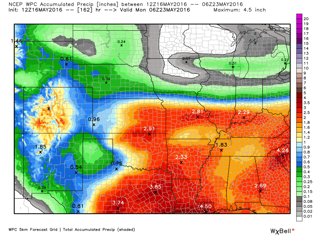
How much precipitation should we expect over the next few days?
Here is the broad-brushed rainfall totals forecast for Monday into Tuesday night. You can see that heavier band over our northern counties.
Northern counties will top 1″ of rain.
Far southeast Missouri into far southern Illinois, western Kentucky, and northwest Tennessee will receive lesser amounts. More in the 0.40″-0.80 range. Keep in mind that thunderstorms can always produce locally higher amounts.

Here are the current river stage forecasts. You can click your state and then the dot for your location. It will bring up the full forecast and hydrograph.
.
.

Here is the official 6-10 day and 8-14 day temperature and precipitation outlook. Check the date stamp at the top of each image (so you understand the time frame).
The forecast maps below are issued by the Weather Prediction Center (NOAA).


The latest 8-14 day temperature and precipitation outlook. Note the dates are at the top of the image. These maps DO NOT tell you how high or low temperatures or precipitation will be. They simply give you the probability as to whether temperatures or precipitation will be above or below normal.


Who do you trust for your weather information and who holds them accountable?
I have studied weather in our region since the late 1970’s. I have 37 years of experience in observing our regions weather patterns. My degree is in Broadcast Meteorology from Mississippi State University and an Associate of Science (AS). I am currently working on my Bachelor’s Degree in Geoscience.
My resume includes:
Member of the American Meteorological Society.
NOAA Weather-Ready Nation Ambassador.
Meteorologist for McCracken County Emergency Management. I served from 2005 through 2015.
I own and operate the Southern Illinois Weather Observatory.
Recipient of the Mark Trail Award, WPSD Six Who Make A Difference Award, Kentucky Colonel, and the Caesar J. Fiamma” Award from the American Red Cross.
In 2009 I was presented with the Kentucky Office of Highway Safety Award.
Recognized by the Kentucky House of Representatives for my service to the State of Kentucky leading up to several winter storms and severe weather outbreaks.
I am also President of the Shadow Angel Foundation which serves portions of western Kentucky and southern Illinois.
There is a lot of noise on the internet. A lot of weather maps are posted without explanation. Over time you should learn who to trust for your weather information.
My forecast philosophy is simple and straight forward.
- Communicate in simple terms
- To be as accurate as possible within a reasonable time frame before an event
- Interact with you on Twitter, Facebook, and the blog
- Minimize the “hype” that you might see on television or through other weather sources
- Push you towards utilizing wall-to-wall LOCAL TV coverage during severe weather events
I am a recipient of the Mark Trail Award, WPSD Six Who Make A Difference Award, Kentucky Colonel, and the Caesar J. Fiamma” Award from the American Red Cross. In 2009 I was presented with the Kentucky Office of Highway Safety Award. I was recognized by the Kentucky House of Representatives for my service to the State of Kentucky leading up to several winter storms and severe weather outbreaks.
If you click on the image below you can read the Kentucky House of Representatives Resolution.

Many of my graphics are from www.weatherbell.com – a great resource for weather data, model data, and more


You can sign up for my AWARE email by clicking here I typically send out AWARE emails before severe weather, winter storms, or other active weather situations. I do not email watches or warnings. The emails are a basic “heads up” concerning incoming weather conditions.