We have some great sponsors for the Weather Talk Blog. Please let our sponsors know that you appreciate their support for the Weather Talk Blog.
Milner and Orr Funeral Home and Cremation Services located in Paducah, Kentucky and three other western Kentucky towns – at Milner and Orr they believe in families helping families. You can find Milner and Orr on Facebook, as well.
![]()
.

For all of your families eye care needs. Visit their web-site here. Or, you can also visit their Facebook page.
.

Best at Enabling Body Shop Profitability since 1996. Located In Paducah Kentucky and Evansville Indiana; serving all customers in between. They provide Customer Service, along with all the tools necessary for body shops to remain educated and competitive. Click the logo above for their main web-site. You can find McClintock Preferred Finishes on Facebook, as well

Expressway Carwash and Express Lube are a locally owned and operated full service Carwash and Lube established in 1987. We have been proudly serving the community for 29 years now at our Park Avenue location and 20 years at our Southside location. We have been lucky enough to partner with Sidecar Deli in 2015, which allows us to provide our customers with not only quality service, but quality food as well. . If you haven’t already, be sure to make Expressway your one stop shop, with our carwash, lube and deli. For hours of operation and pricing visit www.expresswashlube.com or Expressway Carwash on Facebook.

TORNADO SHELTERS! Endrizzi’s Storm Shelters – For more information click here. Endrizzi Contracting and Landscaping can be found on Facebook, as well – click here
I have launched the new weather texting service! I could use your help. Be sure and sign up and fully support all of the weather data you see each day.
This is a monthly subscription service. Supporting this helps support everything else. The cost is $3 a month for one phone, $5 a month for three phones, and $10 a month for seven phones.
For more information visit BeauDodsonWeather.com
Or directly sign up at Weathertalk.com


This forecast update covers far southern Illinois, far southeast Missouri, and far western Kentucky. See the coverage map on the right side of the blog.
Remember that weather evolves. Check back frequently for updates, especially during active weather.

Tuesday Night – Cloudy. A few showers possible.
Temperatures: Lows in the 48-54 degree range
Winds: Winds east/northeast at 5-10 mph. Gusts to 12 mph.
What is the chance for precipitation? 40%. Rain should come to an end on Tuesday night.
Coverage of precipitation: Scattered
My confidence in this part of the forecast verifying is High
Should I be concerned about snow or ice? No
Should I cancel my outdoor plans? No, but monitor radars
Is severe weather expected? No
What impact is expected? Wet roadways. Small chance for lightning before 7 pm.
Rainfall totals for this whole event should range from 1″+ over our northern counties to 0.30″-0.75″ over our southern counties. Less south vs north.
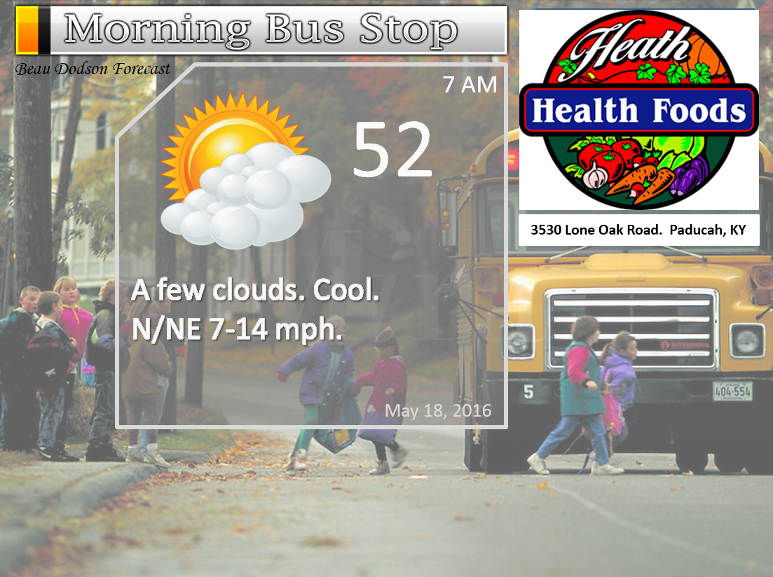
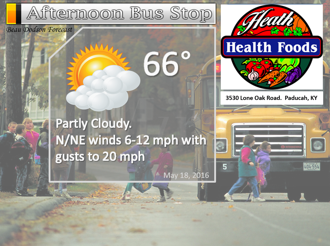
Wednesday – A mix of sun and clouds. Cool.
Temperatures: High temperatures in the 66-72 degree range.
Winds: Northeast and east winds at 7-14 mph with gusts to 20-25 mph.
What is the chance for precipitation? 10%
Coverage of precipitation? None
My confidence in this part of the forecast verifying is High
Should I be concerned about snow or ice? No
Should I cancel my outdoor plans? No
Is severe weather expected? No
What impact is expected? None
Wednesday Night – Partly cloudy. Cool.
Temperatures: Lows in the 48-54 degree range
Winds: Winds east and northeast at 5-10 mph.
What is the chance for precipitation? 0%
Coverage of precipitation: None
My confidence in this part of the forecast verifying is High
Should I be concerned about snow or ice? No
Should I cancel my outdoor plans? No
Is severe weather expected? No
What impact is expected? None
Thursday – Partly to mostly sunny.
Temperatures: High temperatures in the 68-74 degree range.
Winds: East and northeast winds at 6-12 mph. Gusts to 20 mph
What is the chance for precipitation? 0%
Coverage of precipitation? None
My confidence in this part of the forecast verifying is High
Should I be concerned about snow or ice? No
Should I cancel my outdoor plans? No
Is severe weather expected? No
What impact is expected? None
Thursday Night – Partly cloudy. A chance for a shower.
Temperatures: Lows in the 52-56 degree range
Winds: Winds east and northeast at 5-10 mph.
What is the chance for precipitation? 20% before midnight. Increasing to 40%-50% after midnight.
Coverage of precipitation: Increasing coverage possible overnight
My confidence in this part of the forecast verifying is High
Should I be concerned about snow or ice? No
Should I cancel my outdoor plans? No
Is severe weather expected? No
What impact is expected? Wet roadways
Friday – Mostly cloudy. A shower possible.
Temperatures: High temperatures in the 66-72 degree range.
Winds: Variable winds at 6-12 mph with gusts to 18
What is the chance for precipitation? 50%-60%
Coverage of precipitation? Scattered to numerous. Especially for the southern half of the region.
My confidence in this part of the forecast verifying is Medium
Should I be concerned about snow or ice? No
Should I cancel my outdoor plans? No, but monitor radars.
Is severe weather expected? No
What impact is expected? Wet roadways.
Friday Night – Partly to mostly cloudy. Some lingering showers possible.
Temperatures: Lows in the 52-56 degree range
Winds: Winds north and northeast at 5-10 mph. Winds variable in direction at times.
What is the chance for precipitation? 20%-30%
Coverage of precipitation: Isolated
My confidence in this part of the forecast verifying is High
Should I be concerned about snow or ice? No
Should I cancel my outdoor plans? No
Is severe weather expected? No
What impact is expected? Wet roadways.
Saturday – Mostly sunny. Perhaps a few clouds. Not too bad of a day. Breezy at times in open areas.
Temperatures: High temperatures in the 70-75 degree range.
Winds: North and northeast winds at 6-12 mph with gusts to 14-18
What is the chance for precipitation? 0%
Coverage of precipitation? None
My confidence in this part of the forecast verifying is High
Should I be concerned about snow or ice? No
Should I cancel my outdoor plans? No
Is severe weather expected? No
What impact is expected? None
Saturday Night – Mostly clear.
Temperatures: Lows in the 55-60 degree range
Winds: Winds north and northeast at 4-8 mph.
What is the chance for precipitation? 0%
Coverage of precipitation: None
My confidence in this part of the forecast verifying is High
Should I be concerned about snow or ice? No
Should I cancel my outdoor plans? No
Is severe weather expected? No
What impact is expected? None
Sunday – Mostly sunny. Pleasant. Milder.
Temperatures: High temperatures in the 74-78 degree range.
Winds: Northeast and east winds at 10 mph with gusts to 14 mph
What is the chance for precipitation? 0%
Coverage of precipitation? None
My confidence in this part of the forecast verifying is High
Should I be concerned about snow or ice? No
Should I cancel my outdoor plans? No
Is severe weather expected? No
What impact is expected? None
Sunday Night – Mostly clear.
Temperatures: Lows in the 50-55 degree range
Winds: Winds becoming south and southeast at 5-10 mph.
What is the chance for precipitation? 0%
Coverage of precipitation: None
My confidence in this part of the forecast verifying is High
Should I be concerned about snow or ice? No
Should I cancel my outdoor plans? No
Is severe weather expected? No
What impact is expected? None
Monday – Mostly sunny.
Temperatures: High temperatures in the 75-80 degree range.
Winds: South and southeast winds at 5-10 mph with gusts to 12 mph
What is the chance for precipitation? 0%
Coverage of precipitation? None
My confidence in this part of the forecast verifying is High
Should I be concerned about snow or ice? No
Should I cancel my outdoor plans? No
Is severe weather expected? No
What impact is expected? None
Monday Night – Partly cloudy.
Temperatures: Lows in the 56-62 degree range
Winds: Winds south and southeast at 5-10 mph.
What is the chance for precipitation? 0%
Coverage of precipitation: None
My confidence in this part of the forecast verifying is High
Should I be concerned about snow or ice? No
Should I cancel my outdoor plans? No
Is severe weather expected? No
What impact is expected? None
Tuesday – Partly sunny. Warm. A thunderstorm possible.
What impact is expected? Wet roadways and lightning.
Temperatures: High temperatures in the 78-84 degree range.
Winds: South and southwest winds at 5-10 mph with gusts to 22 mph
What is the chance for precipitation? 30%
Coverage of precipitation? Isolated
My confidence in this part of the forecast verifying is Medium
Should I be concerned about snow or ice? No
Should I cancel my outdoor plans? No
Is severe weather expected? Unlikely
Tuesday Night – Partly cloudy. A thunderstorm possible.
What impact is expected? Wet roadways and lightning.
Temperatures: Lows in the 60-64 degree range
Winds: Winds south and southwest at 5-10 mph.
What is the chance for precipitation? 20%
Coverage of precipitation: Isolated
My confidence in this part of the forecast verifying is Low
Should I be concerned about snow or ice? No
Should I cancel my outdoor plans? No
Is severe weather expected? Unlikely
Wednesday – Partly sunny. Warm. A thunderstorm possible.
What impact is expected? Wet roads. Lightning.
Temperatures: High temperatures in the 80-84 degree range.
Winds: South and southwest winds at 6-12 mph
What is the chance for precipitation? 30%
Coverage of precipitation? Scattered
My confidence in this part of the forecast verifying is Low
Should I be concerned about snow or ice? No
Should I cancel my outdoor plans? No
Is severe weather expected? Monitor updates
Wednesday Night – Partly cloudy. Thunderstorm possible.
What impact is expected? Wet roadways. Lightning.
Temperatures: Lows in the 60-64 degree range
Winds: Winds south and southwest at 5-10 mph.
What is the chance for precipitation? 20%
Coverage of precipitation: Scattered
My confidence in this part of the forecast verifying is Low
Should I be concerned about snow or ice? No
Should I cancel my outdoor plans? No
Is severe weather expected? Monitor updates
Thursday – Partly sunny. Warm. A thunderstorm possible.
What impact is expected? Wet roads. Lightning.
Temperatures: High temperatures in the 78-84 degree range.
Winds: South and southwest winds at 6-12 mph
What is the chance for precipitation? 30%
Coverage of precipitation? Scattered
My confidence in this part of the forecast verifying is Low
Should I be concerned about snow or ice? No
Should I cancel my outdoor plans? No
Is severe weather expected? Monitor updates
Thursday Night – Partly cloudy. A thunderstorm possible.
What impact is expected? Wet roadways. Lightning.
Temperatures: Lows in the 60-64 degree range
Winds: Winds south and southwest at 5-10 mph.
What is the chance for precipitation? 20%
Coverage of precipitation: Scattered
My confidence in this part of the forecast verifying is Low
Should I be concerned about snow or ice? No
Should I cancel my outdoor plans? No
Is severe weather expected? Monitor updates
Friday – Partly sunny. Warm.
What impact is expected? Wet roads. Lightning.
Temperatures: High temperatures in the 78-84 degree range.
Winds: South and southwest winds at 6-12 mph
What is the chance for precipitation? 10%
Coverage of precipitation?
My confidence in this part of the forecast verifying is Low
Should I be concerned about snow or ice? No
Should I cancel my outdoor plans? No
Is severe weather expected?
Thursday Night – Partly cloudy.
What impact is expected?
Temperatures: Lows in the 60-64 degree range
Winds: Winds south and southwest at 5-10 mph.
What is the chance for precipitation? 10%
Coverage of precipitation:
My confidence in this part of the forecast verifying is Low
Should I be concerned about snow or ice? No
Should I cancel my outdoor plans? No
Is severe weather expected?
The School Bus Stop Forecast is sponsored by Heath Health and Wellness. Located next to Crowell Pools in Lone Oak, Kentucky.
Visit their web-site here. And. visit Heath Health Foods on Facebook!

The School Bus Stop Forecast is sponsored by Heath Health and Wellness. Located next to Crowell Pools in Lone Oak, Kentucky.
Visit their web-site here. And. visit Heath Health Foods on Facebook!
Heath Health Foods is a locally owned and operated retail health and wellness store. Since opening in February 2006; the store has continued to grow as a ministry with an expanding inventory which also offers wellness appointments and services along with educational opportunities. Visit their web-site here. And. visit Heath Health Foods on Facebook!
The weekend forecast is sponsored by Farmer and Company Real Estate.

The weekend forecast is sponsored by Farmer and Company Real Estate. Click here to visit their site.

Don’t forget to check out the Southern Illinois Weather Observatory web-site for weather maps, tower cams, scanner feeds, radars, and much more! Click here

An explanation of what is happening in the atmosphere over the coming days…
- Cool weather
- Rain likely Thursday night into Friday night
- Monitoring Saturday’s forecast. Dry? Or, storms?
- Dry Sunday
- Much warmer next week. Eighties return!
The main weather story has been the amazingly cool temperatures. Temperatures were well below normal today. How many degrees below normal? The normal low temperature for this time of the year is around 55 degrees and the normal high temperature for this time of the year is around 77 degrees.
Here is a map showing you how many degrees below normal we were on Tuesday. Near record high temperature minimums. Meaning, some of the coolest daytime high temperatures recorded for this time of the year. Brrr?
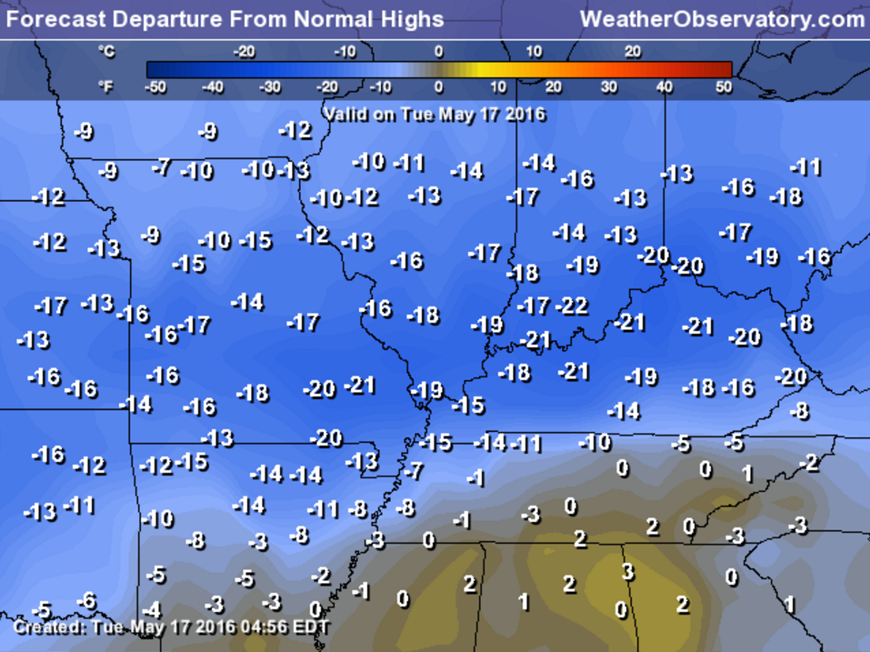
Needless to say, most people are over it. Where is spring? Well, hang on just a little bit longer. I do have good news. Spring is returning later this weekend into next week. We should top out in the 80s several days next week. Just hang tight!!
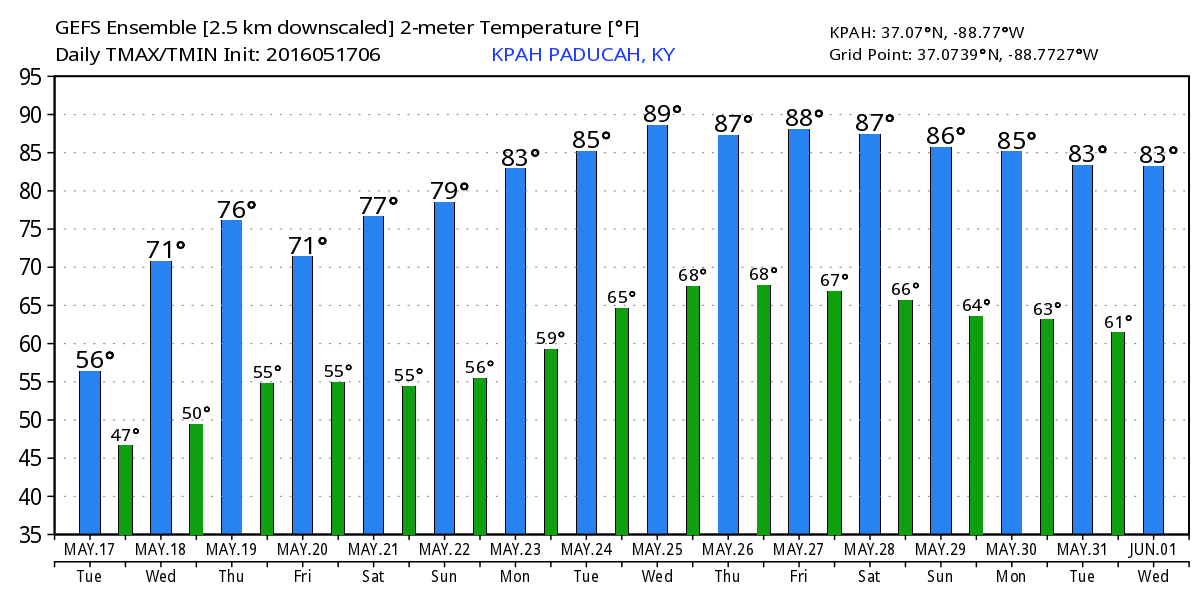
Here is the GFS 16 day high temperature map for western Kentucky. Now, I don’t trust the GFS once it gets beyond a certain range. But, the general idea is that warmer weather is in store for our local area next week. This image is from Weatherbell. The blue bars are high temperatures. Green bars are low temperatures. Dates are at the bottom of the image. Again, guidance and not gospel. This is the GFS models idea for high temperatures in the long range. Warmer, for sure.
Another storm system will approach our region on Thursday night and Friday. This will spark additional showers and thunderstorms. Some of today’s data has backed off the coverage. This will need to be monitored.
Perhaps a few strong storms on Friday. Severe weather risk appears to be low. But, monitor updates, as always.
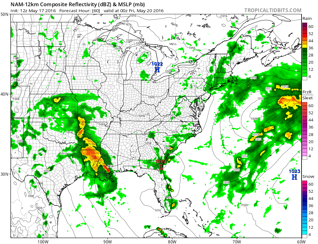
Let’s take a look at some more maps. This is the WRF model guidance. Guidance and not gospel. Meaning that this is the way one model believes everything will play out on Thursday night into Friday evening. Green and yellow represent showers and thunderstorms.
Some of the guidance lingers rain into Friday night and Saturday morning. I went mostly dry on Saturday. But, keep this in mind. Data is not in 100% agreement.
These images can be enlarged by clicking the image.
Some of today’s data has backed off the coverage for Thursday night into Friday. This will need to be monitored.
This first image is for 7 AM on Thursday. You can see showers and thunderstorms to our southwest.
This next image is for 10 pm on Thursday evening.
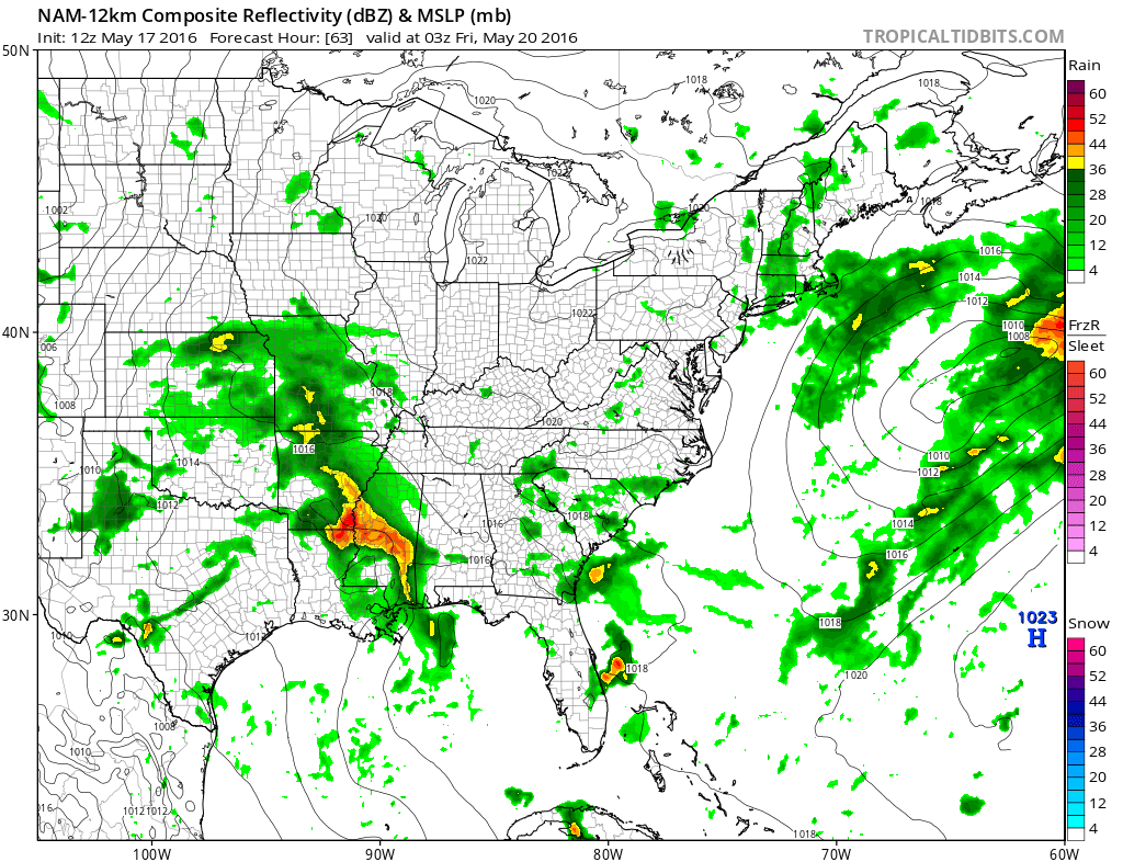
This next image is for 1 am on Friday morning.
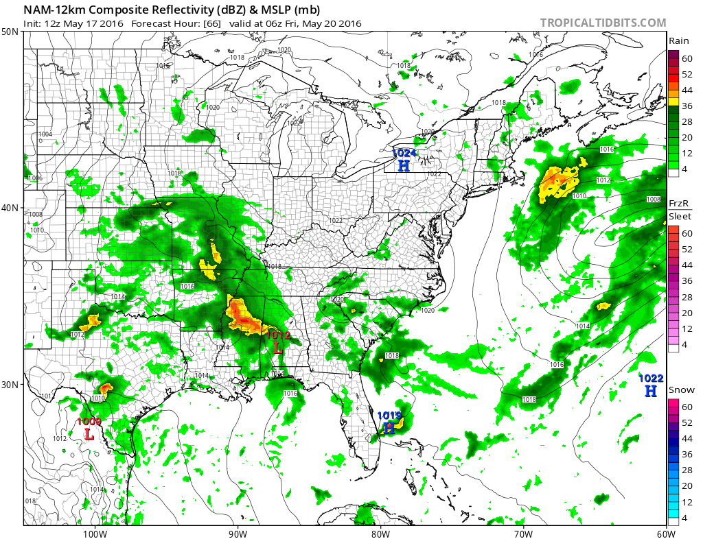
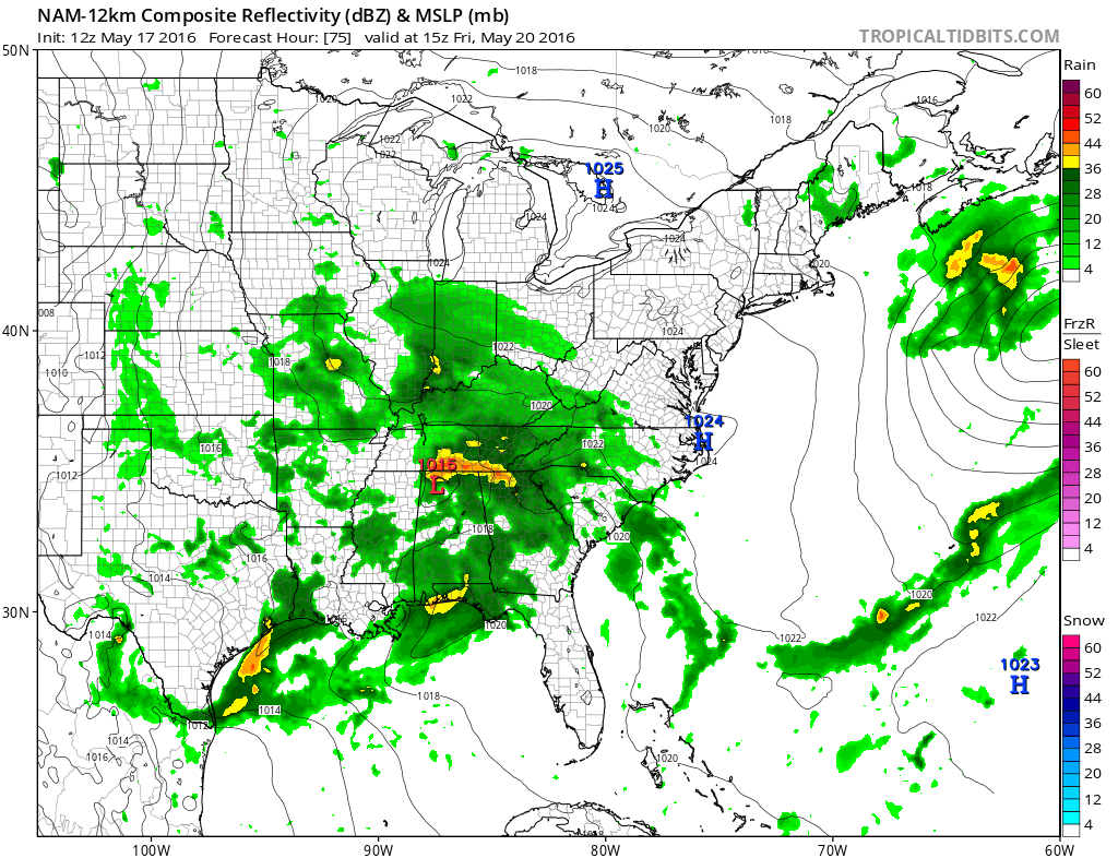
This next image is for Friday morning at 4 am. Widespread showers in our region. Some thunderstorms.
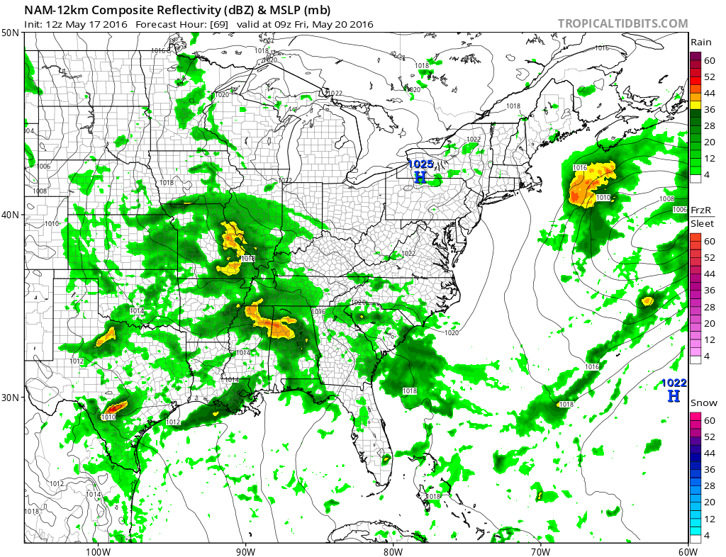
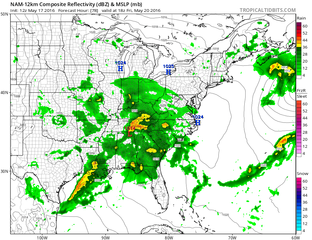
This next image is for Friday morning at 7 am. Could be a wet Friday morning.
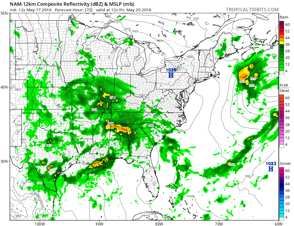
This next image is for 10 am on Friday morning.
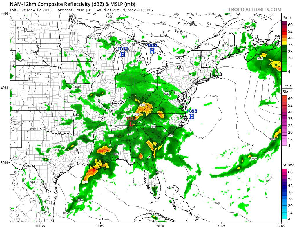
This next image is for 1 pm on Friday afternoon.
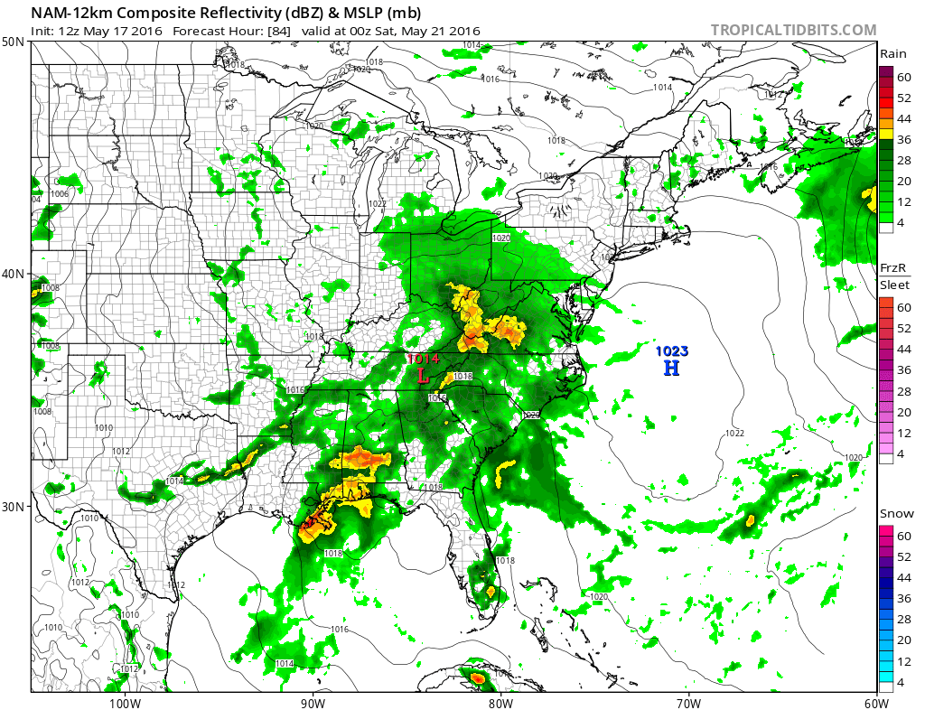
This next image is for 4 pm on Friday afternoon.
This next image is for 7 pm on Friday evening.
Let’s keep an eye on the next weekend into end of month. Stormier pattern possible.
Radar

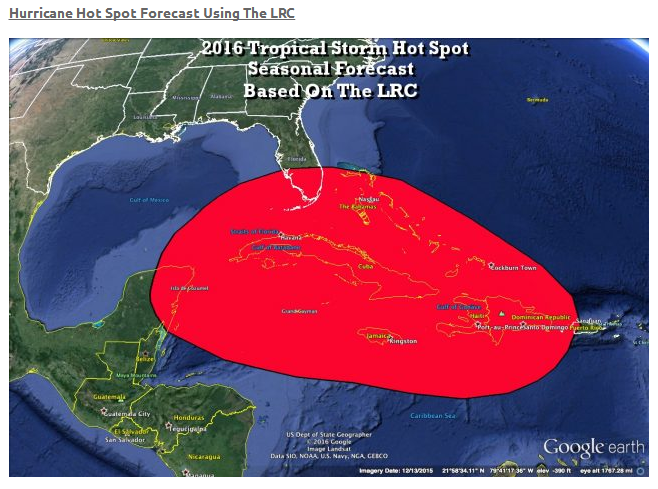
Gary’s Lezak’s long range cycle points to this being a hot spot for tropical weather this summer/fall. It won’t be the only area. But, this area is singled out as the potential for greater problems.

We have regional radars and local city radars – if a radar does not seem to be updating then try another one. Occasional browsers need their cache cleared. You may also try restarting your browser. That usually fixes the problem. Occasionally we do have a radar go down. That is why I have duplicates. Thus, if one fails then try another one.
If you have any problems then please send me an email beaudodson@usawx.com
WEATHER RADAR PAGE – Click here —
We also have a new national interactive radar – you can view that radar by clicking here.
Local interactive city radars include St Louis, Mt Vernon, Evansville, Poplar Bluff, Cape Girardeau, Marion, Paducah, Hopkinsville, Memphis, Nashville, Dyersburg, and all of eastern Kentucky – these are interactive radars. Local city radars – click here

Live Lightning Data – zoom and pan: Click here
Live Lightning Data with sound (click the sound button on the left side of the page): Click here

Can we expect severe thunderstorms over the next 24 to 48 hours? Remember that a severe thunderstorm is defined as a thunderstorm that produces 58 mph winds or higher, quarter size hail or larger, and/or a tornado.
.
Tuesday night: No severe weather.
Wednesday-Thursday: No severe storms
Thursday night: Thunderstorms possible with lightning.
Friday into Friday evening: Thunderstorms possible.
Saturday: Small chance for remaining storms. Low confidence.
Saturday night into Sunday night: No severe weather
Monday: No severe weather.
Tuesday: Monitor updates
.

.
No significant changes in this forecast package.
.

.
No major concerns through Thursday. Thunderstorms possible Thursday night into Friday night.
.

.
No
.

How much precipitation should we expect over the next few days?
Rain comes to an end on Tuesday night. We should dry out on Wednesday and Thursday. Rain returns Thursday night into Friday night. Locally heavy downpours possible.
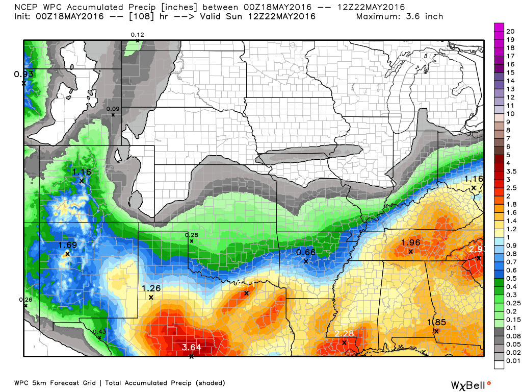
The WPC (they are an arm of NOAA) has rainfall totals being quite high on Thursday night into Friday night. About 0.40-0.50″ of these numbers are from Tuesday/Tuesday night. Keep that in mind. The WPC went too high on this last event. Let’s keep an eye on it. Locally heavy rain is possible on Thursday night into Friday night. Rainfall totals could exceed one inch in spots.
Here is the official WPC map for rainfall totals through Saturday morning. Red colors indicate two inches or more. The yellow and orange colors represent 1′ to 1.8″.
.

Here are the current river stage forecasts. You can click your state and then the dot for your location. It will bring up the full forecast and hydrograph.
.
.

Here is the official 6-10 day and 8-14 day temperature and precipitation outlook. Check the date stamp at the top of each image (so you understand the time frame).
The forecast maps below are issued by the Weather Prediction Center (NOAA).


The latest 8-14 day temperature and precipitation outlook. Note the dates are at the top of the image. These maps DO NOT tell you how high or low temperatures or precipitation will be. They simply give you the probability as to whether temperatures or precipitation will be above or below normal.


Who do you trust for your weather information and who holds them accountable?
I have studied weather in our region since the late 1970’s. I have 37 years of experience in observing our regions weather patterns. My degree is in Broadcast Meteorology from Mississippi State University and an Associate of Science (AS). I am currently working on my Bachelor’s Degree in Geoscience.
My resume includes:
Member of the American Meteorological Society.
NOAA Weather-Ready Nation Ambassador.
Meteorologist for McCracken County Emergency Management. I served from 2005 through 2015.
I own and operate the Southern Illinois Weather Observatory.
Recipient of the Mark Trail Award, WPSD Six Who Make A Difference Award, Kentucky Colonel, and the Caesar J. Fiamma” Award from the American Red Cross.
In 2009 I was presented with the Kentucky Office of Highway Safety Award.
Recognized by the Kentucky House of Representatives for my service to the State of Kentucky leading up to several winter storms and severe weather outbreaks.
I am also President of the Shadow Angel Foundation which serves portions of western Kentucky and southern Illinois.
There is a lot of noise on the internet. A lot of weather maps are posted without explanation. Over time you should learn who to trust for your weather information.
My forecast philosophy is simple and straight forward.
- Communicate in simple terms
- To be as accurate as possible within a reasonable time frame before an event
- Interact with you on Twitter, Facebook, and the blog
- Minimize the “hype” that you might see on television or through other weather sources
- Push you towards utilizing wall-to-wall LOCAL TV coverage during severe weather events
I am a recipient of the Mark Trail Award, WPSD Six Who Make A Difference Award, Kentucky Colonel, and the Caesar J. Fiamma” Award from the American Red Cross. In 2009 I was presented with the Kentucky Office of Highway Safety Award. I was recognized by the Kentucky House of Representatives for my service to the State of Kentucky leading up to several winter storms and severe weather outbreaks.
If you click on the image below you can read the Kentucky House of Representatives Resolution.

Many of my graphics are from www.weatherbell.com – a great resource for weather data, model data, and more


You can sign up for my AWARE email by clicking here I typically send out AWARE emails before severe weather, winter storms, or other active weather situations. I do not email watches or warnings. The emails are a basic “heads up” concerning incoming weather conditions.