1 PM Update
I have posted my snowfall and sleet probabilities
If you end up with more sleet then that really cuts down on snow totals. Less sleet and then you have deeper snow. Sleet does not accumulate as much as snow.
We have our first sponsor for the blog. Milner and Orr Funeral Home and Cremation Services located in Paducah, Kentucky and three other western Kentucky towns – at Milner and Orr they believe in families helping families.
![]()

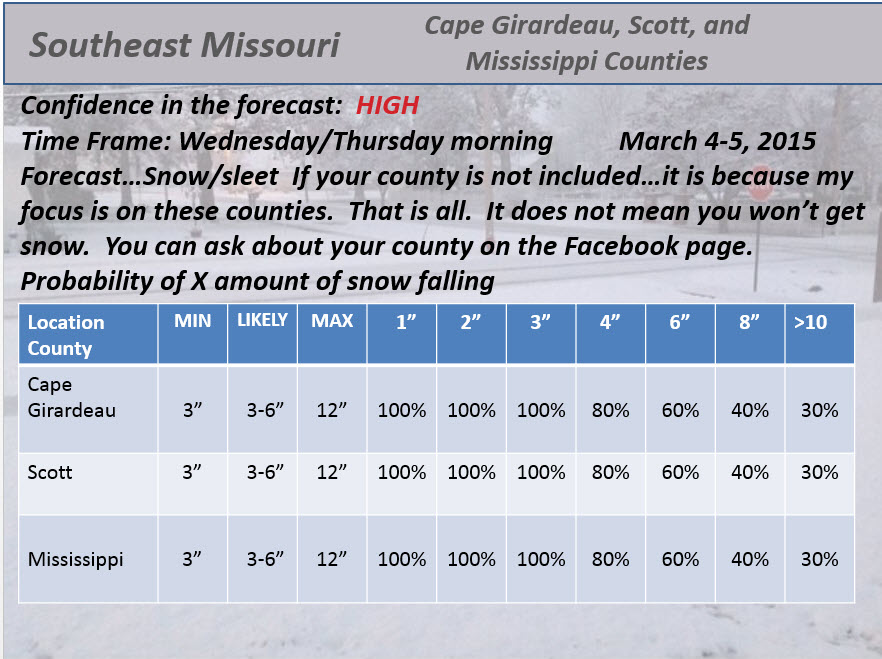
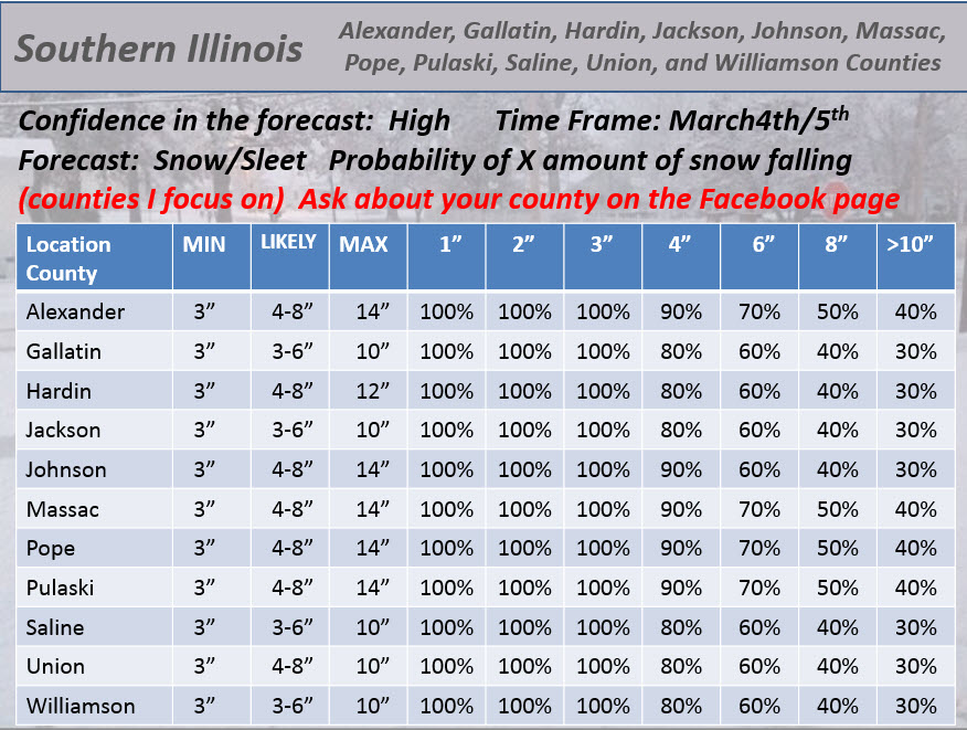
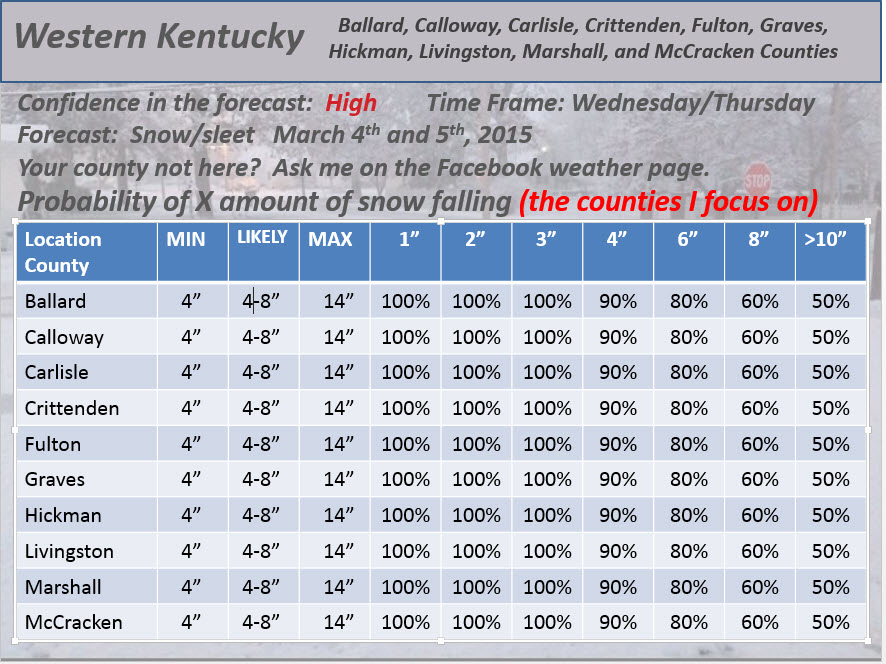
This forecast update covers far southern Illinois, far southeast Missouri, and far western Kentucky. See the coverage map on the right side of the blog.
Remember that weather evolves. Check back frequently for updates, especially during active weather.
I am asking people to consider subscribing to my data. This would help me with costs and my time. I have set up a PayPal subscription option. It has as low as $2 a month (upward). This would really help me with off-setting costs and turning this into a viable business for myself. I have done this for the past 10 years…for free. But, with some life changes, I need to try and turn this into a viable business for myself.
If you would consider this then click the link below and it will take you to the page to subscribe (or make a one time donation)
or click here – the subscribe button.
What do you receive with your subscription?
1. The AWARE emails – you can sign up for those here
2. The one on one interaction for you and your family on Facebook, Twitter, and email.
3. The Weather Observatory web-site.
4. The Weather Observatory local city interactive radars
5. The weather graphics that can be found in the forecast section of the Weather Observatory web-site
6. Contests, from time to time, for weather radios
7. My time and energy!
What do you get if you don’t subscribe? The same. Nobody has to give. But, if you can give (even $2 a month – you can’t even buy a soda at the movies for $2) then it will quickly add up. I know some will give more and I know there are some who may not be able to give anything. But, I appreciate all of you for helping to grow this small sprout into what it is today. This truly is a Jack and the beanstalk story.
BACK TO THE WEATHER!
A major winter storm will develop late tonight and continue into Wednesday night. I will be posting live updates on the Beau Dodson Weather Facebook page and here on the blog. All updates will be at the top of the page. Please see them. I will time stamp them.
Heavy rain will develop tonight, as well. The heaviest rain will be along and south of the Ohio River. Rainfall totals of 1-2″ will likely occur in some counties. This could cause some flooding concerns. The ground is frozen.
Snow and sleet develop by early morning over northern counties – Farmington, MO to Mt Vernon, IL to White County, IL first and then slides south. I am thinking the freezing line reaches the Ohio River between 8 am and 12 pm. Subject to changes…some data brings it in early and some a tad later. I will try to work on this today.
The bottom line is that big snow and sleet totals are likely over our region on Wednesday into Wednesday night. Precipitation will come down hard and fast. Sleet with thunder is likely…snow with thunder is likely.
We could see 1-2″ per hour snowfall rates at times. Sleet will pour from the sky in some areas. This will cause roads to rapidly deteriorate.
I am working on updates…watch for them at the top of the page.
This morning’s school bus stop forecast
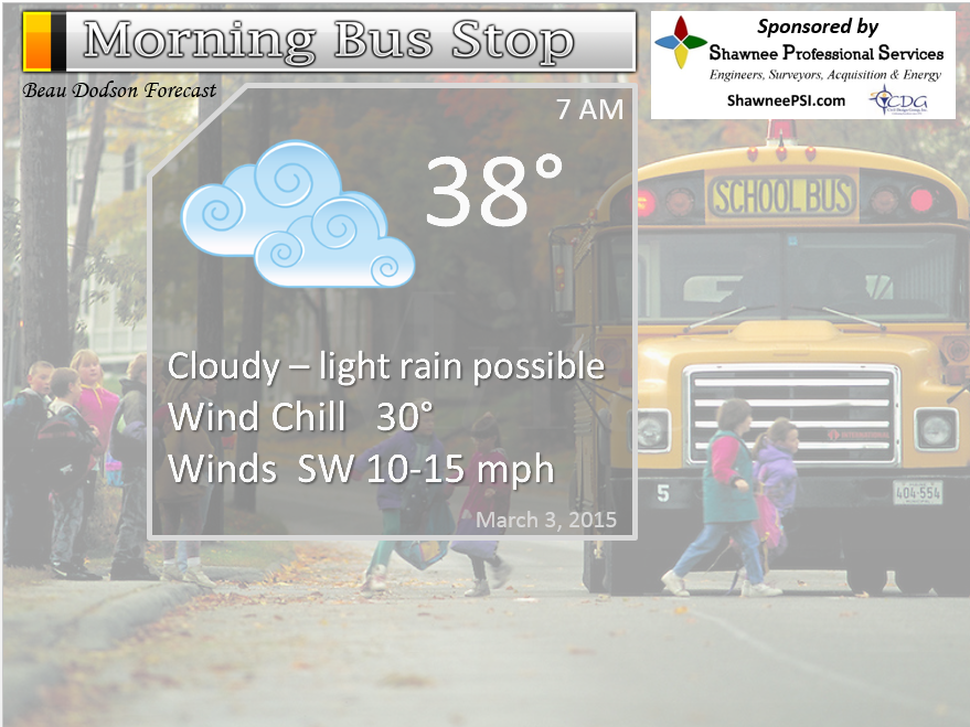
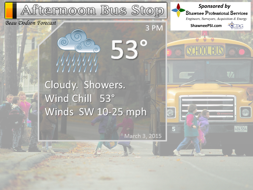
The School Bus Stop Forecast is brought to your by Shawnee Professional Services. For more information click here

Shawnee Professional Services & Civil Design Group have been providing Land Surveying, Engineering, Grant Administration and Acquisition services for the past 20 years.
Currently Licensed in Illinois, Kentucky, Missouri, Indiana, and Tennessee; please contact Shawnee for any Land Surveying or Engineering needs.
Shawnee’s company size allows them to devote individual attention to each client and to approach each project with the required thoroughness to successfully complete the project, large or small.
Shawnee combines innovative thinking and proven techniques, completing projects cost-effectively for their clients. Visit Shawnee’s website at shawneepsi.com for more information. Shawnee has offices in Paducah, KY, Vienna, IL and Benton, IL.

An explanation of what is happening in the atmosphere over the coming days…
A major winter storm is developing for the region.
I will post updates today at the top of the page. There will be several.
Heavy rain likely tonight with thunderstorms possible – esp along and south of the Ohio River. Snow and sleet develop from north to south on Wednesday morning and into the afternoon. Cold air arrives first over southern Illinois and then moves southward through the morning and early afternoon hours.
We should all be below freezing by the middle of the afternoon. Most areas will be below freezing by late morning and early afternoon.
If this is more sleet than snow then 1-3″ of sleet with 3-6″ of snow on top. If this is more snow than sleet then some areas will receive more than 6″ of snow. I will do my best on the updates today at the top of the page.
Main idea is that this is a major winter storm. High impact for travel.
Current advisories – click graphic and then click down to your county
THESE ARE THE National Weather Service forecast numbers and data

WEATHER RADAR PAGE – Click here —
We also have a new national interactive radar – you can view that radar by clicking here.
Local interactive city radars include St Louis, Mt Vernon, Evansville, Poplar Bluff, Cape Girardeau, Marion, Paducah, Hopkinsville, Memphis, Nashville, Dyersburg, and all of eastern Kentucky – these are interactive radars. Local city radars – click here
NOTE: Occasionally you will see ground clutter on the radar (these are false echoes). Normally they show up close to the radar sites – including Paducah.


Trover’s Equipment and Lawn Care Facebook Page – Family owned and operated! They are a dealer for Snapper, Simplicity, Snapper Pro, Bad Boy Mowers, and Intimidator Utility Vehicles. They are a Stihl and Dolmar power products dealer. They also are a dealer for Briggs & Stratton, Kohler gas & diesel engines, and Kawasaki engines. They service and repair just about any brand.

Heavy rain tonight could cause some flash flooding or general flooding in flood prone areas. Use care if you come across a flooded roadway.
Heavy snow and sleet likely on Wednesday morning through Wednesday night. Copious amounts likely. Major travel problems Wednesday into Friday morning. Some areas could be shut down if the big totals verify.
Check out our newest sponsors $5 meal! The DQ Grill and Chill (located across from Noble Park in Paducah, Kentucky) is the newest WeatherTalk Blog sponsor! A local business helping to sponsor the weather information that you have come to love so much.
They have a Facebook Page and I encourage you to check it out. DQ Grill and Chill on Facebook


The wild card tells you where the uncertainties are in the forecast
Wild card in this forecast – How much sleet vs snow falls. This is a big debate right now among forecasters. Either way, this is a big winter storm with a lot of sleet and snow (both).
Please check out our sponsors! G&C Multi-Services out of Paducah, Kentucky. G & C Multi-Services is a service provider in Western Kentucky that provides industrial and commercial equipment fabrication, machine troubleshooting, repair and maintenance, and installation. They can custom fabricate steel, stainless, and aluminum products per customer specifications.
Visit their web-site here. Or click the ad below! They have a Facebook page and it can be viewed here.


Brand new sponsor – working on getting this ad into the right side bar 🙂 But, I wanted to post it today. Wortham Dental’s website
And another new sponsor is Reese Baker Photography


Can we expect severe thunderstorms over the next 24 to 48 hours? Remember that a severe thunderstorm is defined as a thunderstorm that produces 58 mph winds or higher, quarter size hail or larger, and/or a tornado.
Thunderstorm threat level is ONE. Thunderstorms are possible. Also thundersnow and sleet are likely with the winter storm. Heavy precipitation totals will occur with this system.


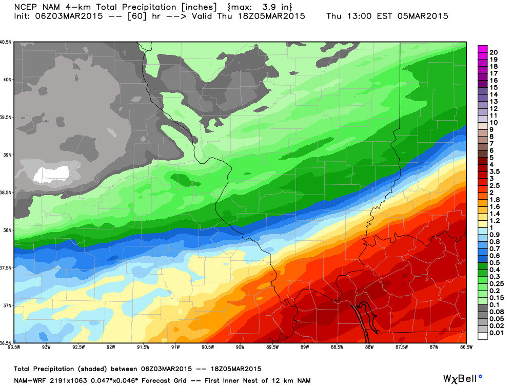
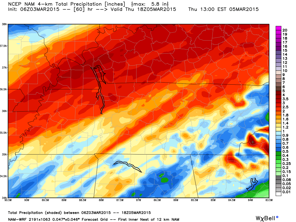
How much precipitation should we expect over the next few days?
Lot of precipitation will fall between now and Thursday morning
These are the totals of rain before 6 am on Wednesday. The snow comes after this time
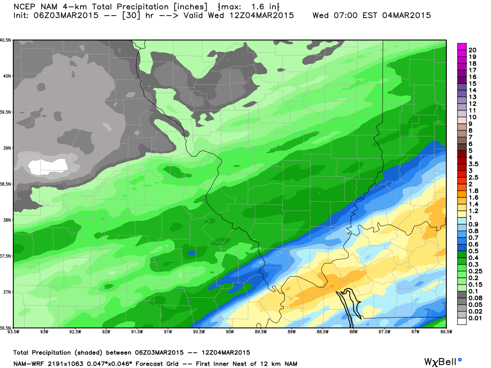
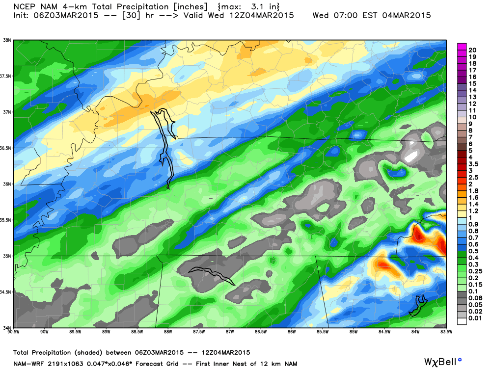
Now, let’s add it all up. Sleet, snow, rain – this is liquid totals
We have regional radars and local city radars – if a radar does not seem to be updating then try another one. Occasional browsers need their cache cleared. You may also try restarting your browser. That usually fixes the problem. Occasionally we do have a radar go down. That is why I have duplicates. Thus, if one fails then try another one.
If you have any problems then please send me an email beaudodson@usawx.com
WEATHER RADAR PAGE – Click here —
We also have a new national interactive radar – you can view that radar by clicking here.
Local interactive city radars include St Louis, Mt Vernon, Evansville, Poplar Bluff, Cape Girardeau, Marion, Paducah, Hopkinsville, Memphis, Nashville, Dyersburg, and all of eastern Kentucky – these are interactive radars. Local city radars – click here
NOTE: Occasionally you will see ground clutter on the radar (these are false echoes). Normally they show up close to the radar sites – including Paducah.
Regional Radar – Click on radar to take you our full radar page.


Regional Radar

Live Lightning Data – zoom and pan: Click here
Live Lightning Data with sound (click the sound button on the left side of the page): Click here
![]()
Current WARNINGS (a warning means take action now). Click on your county to drill down to the latest warning information. Keep in mind that there can be a 2-3 minute delay in the updated warning information.
I strongly encourage you to use a NOAA Weather Radio or warning cell phone app for the most up to date warning information. Nothing is faster than a NOAA weather radio.


Color shaded counties are under some type of watch, warning, advisory, or special weather statement. Click your county to view the latest information.

Missouri Warnings

Illinois Warnings

Kentucky Warnings

Please visit your local National Weather Service Office by clicking here. The National Weather Service Office, for our region, is located in Paducah, Kentucky. They have a lot of maps and information on their site. Local people…local forecasters who care about our region.
Many of my graphics are from www.weatherbell.com – a great resource for weather data, model data, and more

Who do you trust for your weather information and who holds them accountable?
I have studied weather in our region since the late 1970’s. I have 37 years of experience in observing our regions weather patterns. My degree is in Broadcast Meteorology from Mississippi State University and an Associate of Science (AS). I am currently working on my Bachelor’s Degree in Geoscience. Just need to finish two Spanish classes!
I am a member of the American Meteorological Society. I am a NOAA Weather-Ready Nation Ambassador. And, I am the Meteorologist for McCracken County Emergency Management.
I own and operate the Southern Illinois Weather Observatory.
There is a lot of noise on the internet. A lot of weather maps are posted without explanation. Over time you should learn who to trust for your weather information.
My forecast philosophy is simple and straight forward.
- Communicate in simple terms
- To be as accurate as possible within a reasonable time frame before an event
- Interact with you on Twitter, Facebook, and the blog
- Minimize the “hype” that you might see on television or through other weather sources
- Push you towards utilizing wall-to-wall LOCAL TV coverage during severe weather events
I am a recipient of the Mark Trail Award, WPSD Six Who Make A Difference Award, Kentucky Colonel, and the Caesar J. Fiamma” Award from the American Red Cross. In 2009 I was presented with the Kentucky Office of Highway Safety Award. I was recognized by the Kentucky House of Representatives for my service to the State of Kentucky leading up to several winter storms and severe weather outbreaks.
If you click on the image below you can read the Kentucky House of Representatives Resolution.

I am also President of the Shadow Angel Foundation which serves portions of western Kentucky and southern Illinois.


This blog was inspired by ABC 33/40’s Alabama Weather Blog – view their blog
Current tower cam view from the Weather Observatory- Click here for all cameras.

Southern Illinois Weather Observatory

The Weather Observatory

Southern Illinois Weather Observatory
WSIL TV 3 has a number of tower cameras. Click here for their tower camera page & Illinois Road Conditions

Marion, Illinois
WPSD TV 6 has a number of tower cameras. Click here for their tower camera page & Kentucky Road Conditions & Kentucky Highway and Interstate Cameras

Downtown Paducah, Kentucky
Benton, Kentucky Tower Camera – Click here for full view

Benton, Kentucky

I24 Paducah, Kentucky

I24 Mile Point 9 – Paducah, KY

I24 – Mile Point 3 Paducah, Kentucky

You can sign up for my AWARE email by clicking here I typically send out AWARE emails before severe weather, winter storms, or other active weather situations. I do not email watches or warnings. The emails are a basic “heads up” concerning incoming weather conditions.