We have our first sponsor for the blog. Milner and Orr Funeral Home and Cremation Services located in Paducah, Kentucky and three other western Kentucky towns – at Milner and Orr they believe in families helping families.
![]()

This forecast update covers far southern Illinois, far southeast Missouri, and far western Kentucky. See the coverage map on the right side of the blog.
Remember that weather evolves. Check back frequently for updates, especially during active weather.
TORNADO DRILL TODAY IN KENTUCKY – YOU MAY HEAR THE OUTDOOR WARNING SIRENS and you may receive a tornado warning on your cell phones/other
Tuesday – Some morning fog. Rain likely. Moderate rain at times. Rain will taper off this afternoon. Highs in the 50’s with light northeast winds. My confidence in this part of the forecast verifying is high
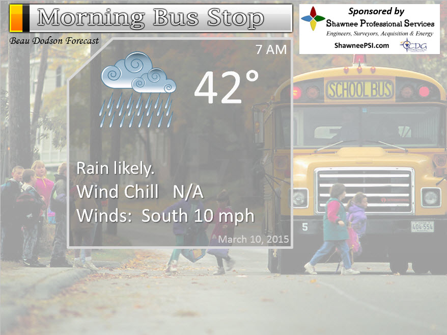
Morning School Bus Stop Weather – Cloudy with rain. Temperatures mainly in the 40’s. Northeast winds at 10 mph. Chances of schools being delayed because of the weather low.
—————————————————————————————-
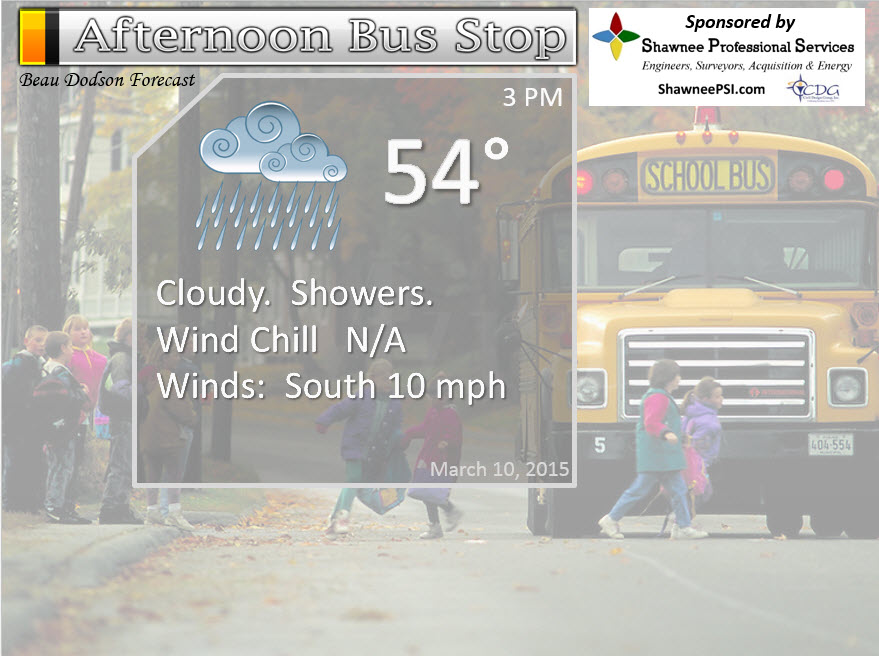
Afternoon School Bus Stop Weather – Cloudy with some rain still in the area. Temperatures in the 50’s with northeast winds at 5-10 mph.
Tuesday night – Cloudy. Rain will have come to an end. Lows mainly in the 40’s. North/northeast winds at 5-10 mph. My confidence in this part of the forecast verifying is high
Wednesday– Cloudy. Mild – spring like. Highs in the 60’s. Northeast winds at 5 mph. My confidence in this part of the forecast verifying is high
Wednesday night – Cloudy. Lows in the 40’s. Northeast winds at 5-10 mph. My confidence in this part of the forecast verifying is high
Thursday – A mix of sun and clouds. Spring like. A chance for afternoon showers. Highs in the upper 50’s to lower 60’s. Northeast winds at 10 mph. My confidence in this part of the forecast verifying is medium
The School Bus Stop Forecast is brought to your by Shawnee Professional Services. For more information click here

Current Temperatures Around The Local Area


An explanation of what is happening in the atmosphere over the coming days…
Well, I promised you some rain. The rain has arrived. Spring rain – eerrr late winter rain? Seems to be! I guess it could always be worse. It could have been more ice and snow. Let’s count our blessings and move on. A significant cold snap is likely the week of March 20th. I continue to watch this.
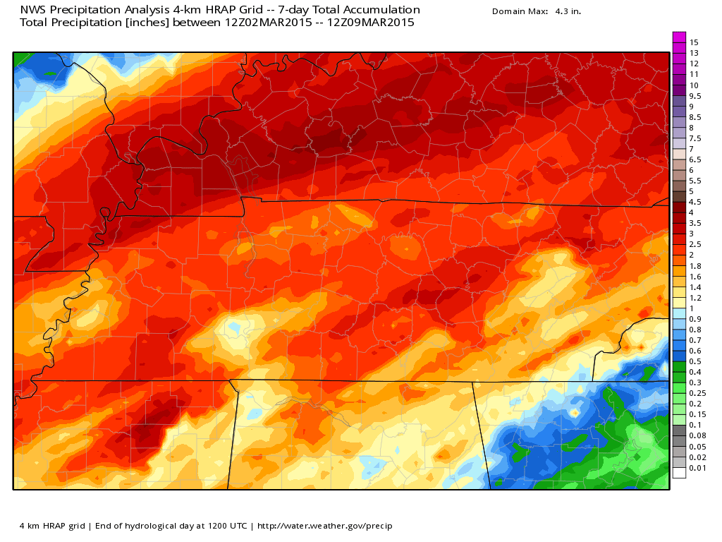
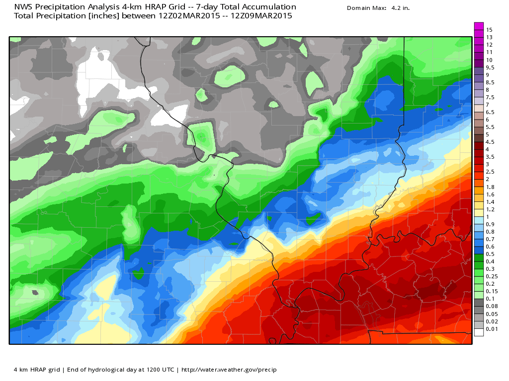
Let’s take a look at the past seven days. How much rain and snow has fallen over our region? If you melted it all down, this would be the totals
Kentucky view – scale is on the right. Images are from weatherbell.com
You can always click images for larger views.
Eastern Missouri and southern Illinois view – scale is on the right
And a regional view – scale is on the right (this is PAST rainfall – from the last 7 days).
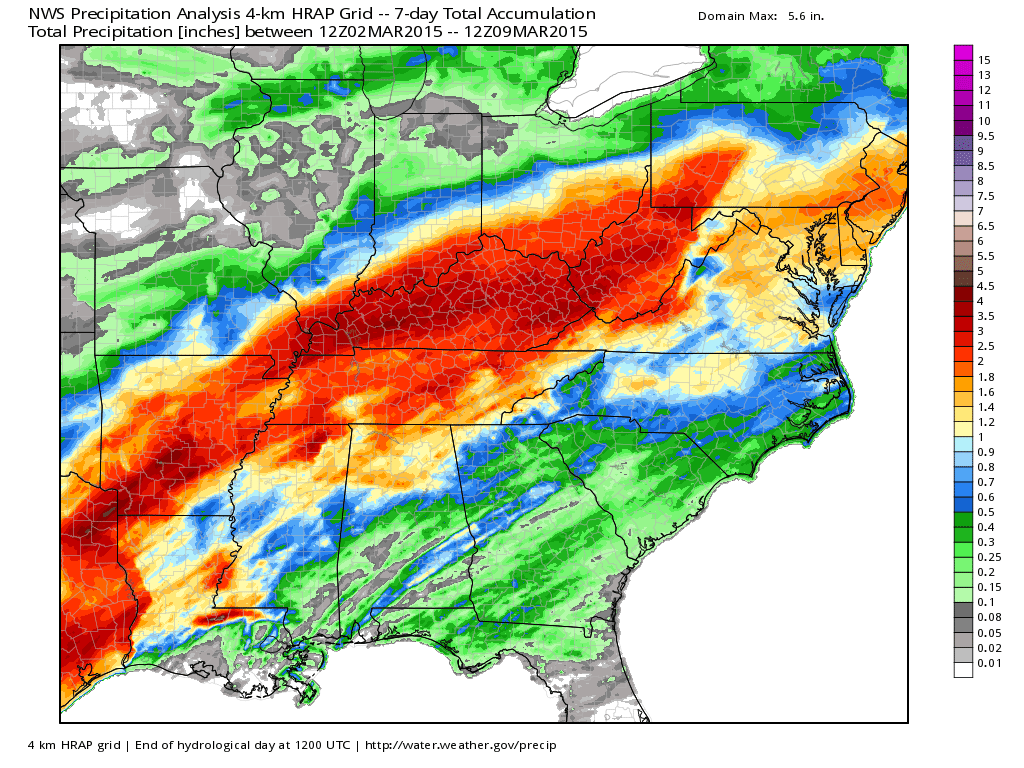
This is why we don’t need additional moisture. But, two storm systems are going to give us just that.
Today (Tuesday)…
Rain will taper Tuesday afternoon and should exit during the evening hours. That will leave us with semi-mild air for the rest of the week.
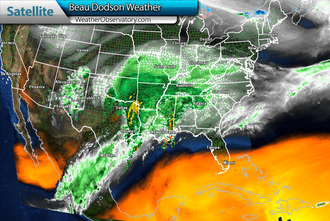
You can see the large storm system on the water vapor satellite imagery. That is a lot of moisture (Monday evening screen grab). The moisture pull is coming up from the Pacific Ocean and the Gulf of Mexico. Hmmm sounds familiar? We saw the same thing happen with the snow storm. We are going to see a repeat later this week. Click image for a larger view.
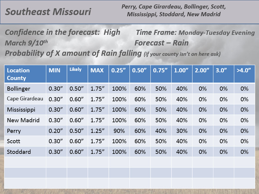
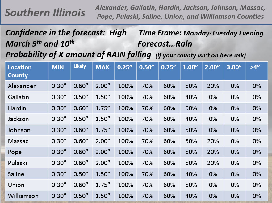
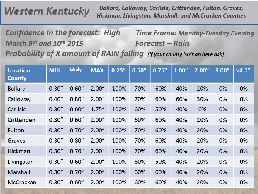
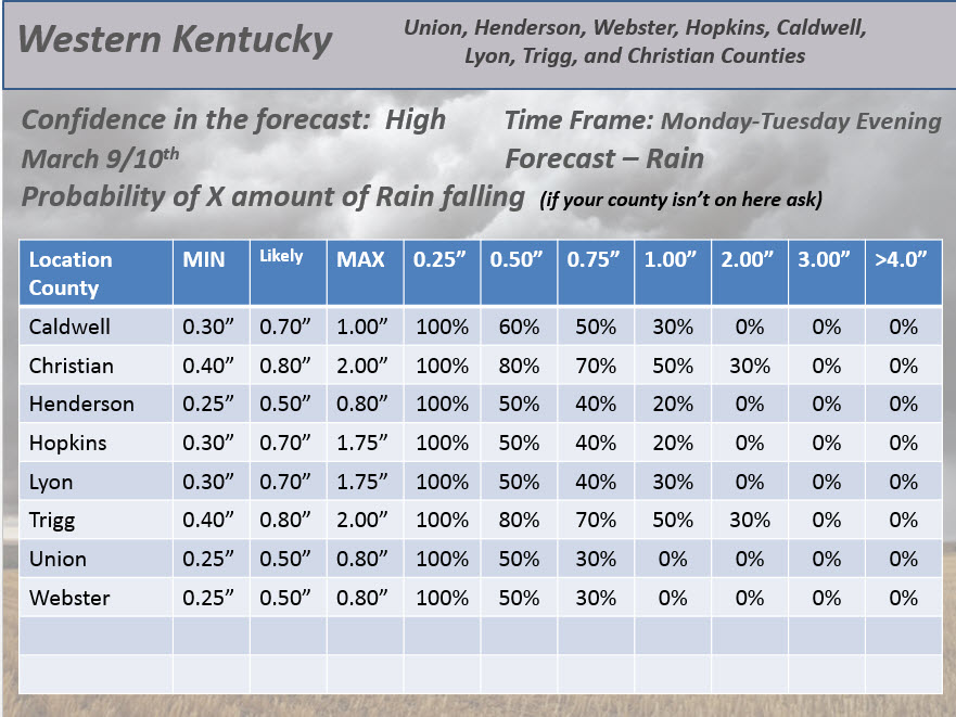
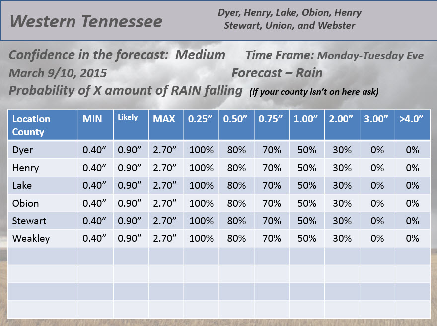
Rainfall totals will be moderate to locally heavy. Widespread 0.50″ to 1.00″ totals. See the probability charts below to get an idea of how much might fall in your county.
Here we go – this is my best forecast thoughts on how much rain will fall and the over/under. These were updated yesterday evening (increased totals a bit)
I may still be too low in the LIKELY category. But, the probabilities handle the higher potential.
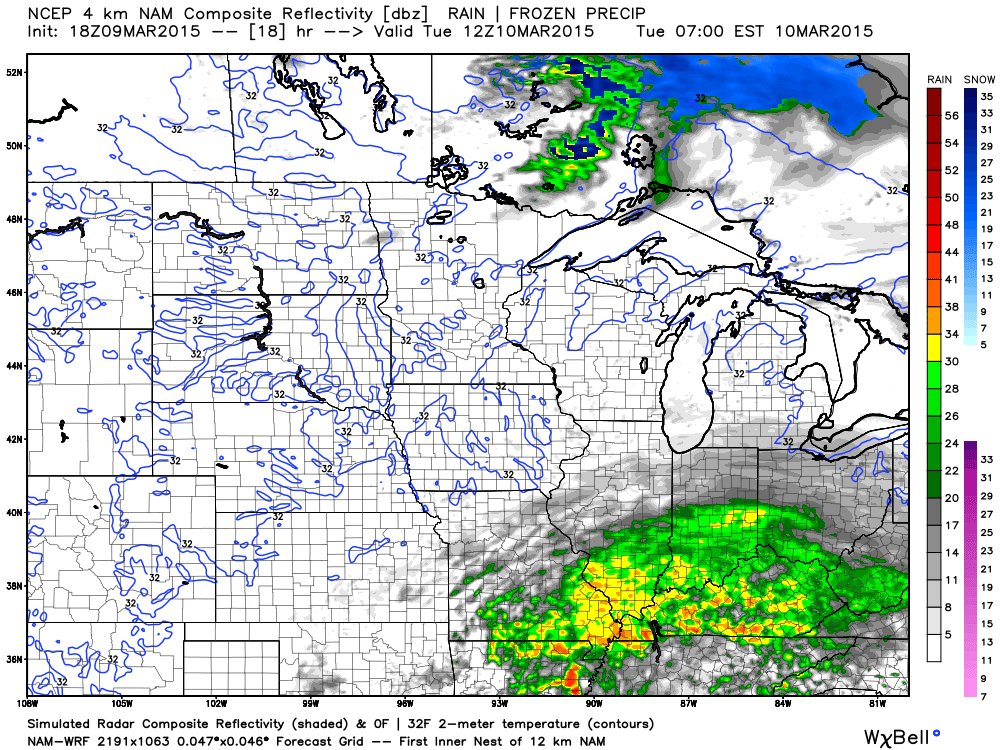
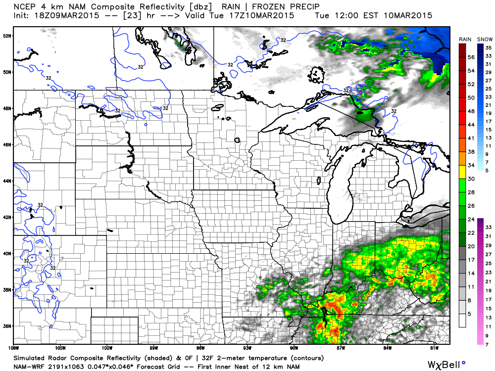
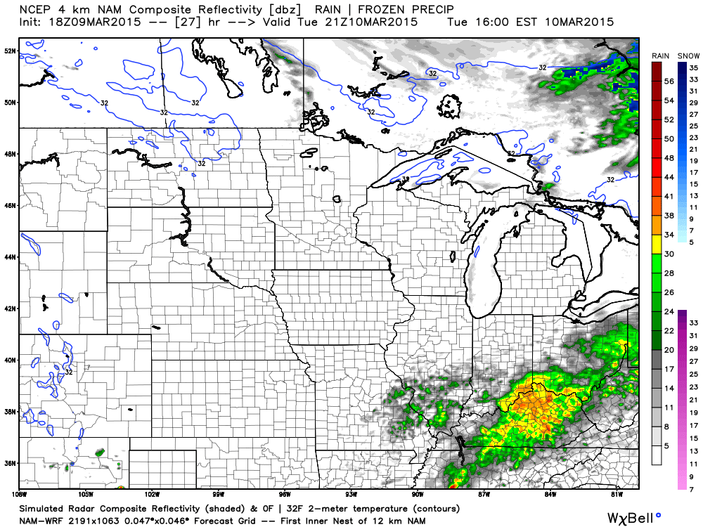
Let’s take a look at the high resolution NAM model’s future-cast radar. Rain will cover the area into Tuesday morning. Rain exits on Tuesday afternoon.
6 AM (Tuesday morning) Future-cast radar. All of those colors are rain (DBz numbers). The yellow would be some moderate rain.
11 AM future-cast radar
3 PM – 4 PM Future-cast radar. Rain is moving out!
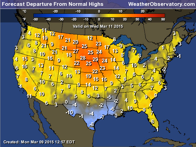
I have included the words “spring-like” in the Wednesday and Thursday forecast. We may see some 60’s in the region! A lot of clouds on Wednesday and Thursday.
Check out the anomalies for Wednesday. Temperatures will be a little above normal. Check out the Northern Plains. Well above normal temperatures in that part of the country. The normal high temperature for southern Illinois and western Kentucky is around 56 degrees.
Overnight lows will remain above freezing for the rest of the week. Shocking, I know!
Another big rain maker arrives late in the week. See the extended discussion below for the details on that one.
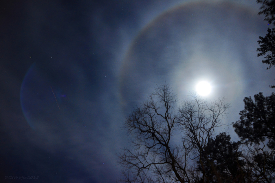
A cool photograph from the Wunderground web-site of a halo around the moon. I thought you might like it.
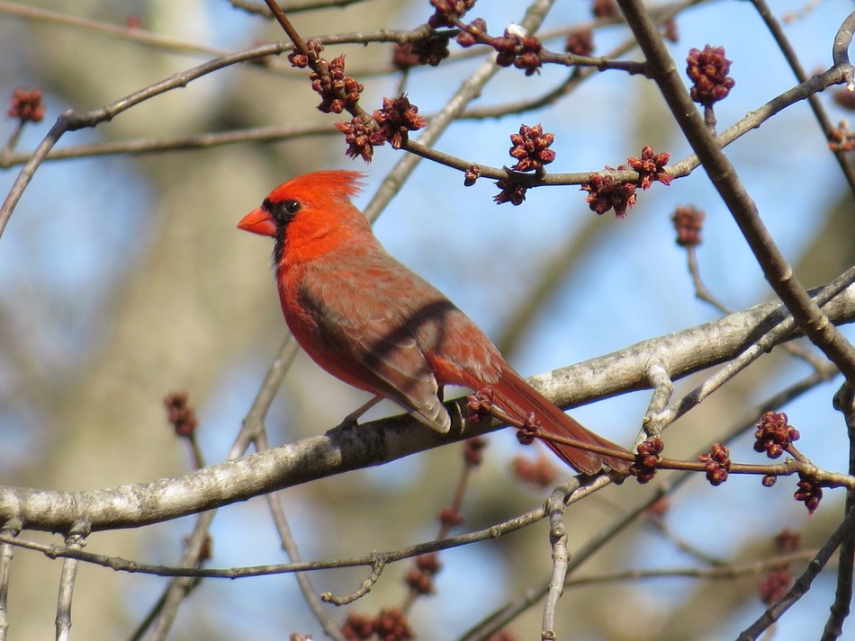
And a Cardinal – no doubt thinking about spring. Image is from Wunderground
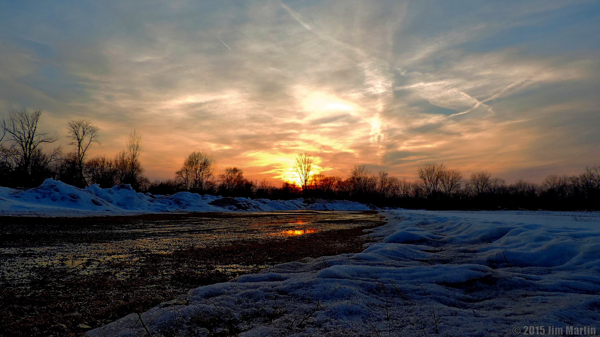
And, one more photograph from one of my friends. He lives in Findlay, Ohio.
Photographer Jim Martin
We have some flood warnings in the region. You can view those by clicking on this map and drilling down to your local county.


Radars to track the precipitation…
WEATHER RADAR PAGE – Click here —
We also have a new national interactive radar – you can view that radar by clicking here.
Local interactive city radars include St Louis, Mt Vernon, Evansville, Poplar Bluff, Cape Girardeau, Marion, Paducah, Hopkinsville, Memphis, Nashville, Dyersburg, and all of eastern Kentucky – these are interactive radars. Local city radars – click here

Don’t forget that I am trying to get people to sign up for a small monthly donation. A lot of people are giving between $2-$5. If I can build this base larger then it will help cover my costs and the time I put into all of this. I do not work for a TV or radio station.
The subscribe button.

Updated temperatures and wind speed. Otherwise, the forecast is pretty much on track.

We have a lot of rain falling on top of the soggy ground. This will cause a lot of run-off today. Streams may rise and some pockets of low land flooding possible. Flash flood risk is low. Some general flooding in low lying areas will be possible (those areas that normally have some water issues). Rivers will be on the rise this week and next week. Keep that in mind. Lot of water coming down the pike.
Check out our sponsors! There are more on the right side bar of the page, as well. Be sure and let them know that you appreciate their sponsorship of the WeatherTalk daily weather bulletin.
How about a $5 meal deal? The DQ Grill and Chill (located across from Noble Park in Paducah, Kentucky) is the newest WeatherTalk Blog sponsor! A local business helping to sponsor the weather information that you have come to love so much.
Check out their Facebook page for specials, as well DQ Grill and Chill on Facebook


Premier Portable Buildings proudly serving our region. For more information click the above ad or here
They can also be found on this Facebook page

G&C Multi-Services out of Paducah, Kentucky. G & C Multi-Services is a service provider in Western Kentucky that provides industrial and commercial equipment fabrication, machine troubleshooting, repair and maintenance, and installation. They can custom fabricate steel, stainless, and aluminum products per customer specifications.
Visit their web-site here. Or click the ad below! Facebook page.

Wortham Dental Care located in Paducah, Kentucky. The gentle dentist. Mercury free dentistry. They also do safe Mercury removal. You can find Wortham Dental Care on Facebook, as well

Trover’s Equipment and Lawn Care – Family owned and operated! They are a dealer for Snapper, Simplicity, Snapper Pro, Bad Boy Mowers, and Intimidator Utility Vehicles. They are a Stihl and Dolmar power products dealer. They also are a dealer for Briggs & Stratton, Kohler gas & diesel engines, and Kawasaki engines. They service and repair just about any brand. You can find them on Facebook, as well
The School Bus Stop Forecast is brought to your by Shawnee Professional Services. For more information click here

Shawnee Professional Services & Civil Design Group have been providing Land Surveying, Engineering, Grant Administration and Acquisition services for the past 20 years. Currently Licensed in Illinois, Kentucky, Missouri, Indiana, and Tennessee; please contact Shawnee for any Land Surveying or Engineering needs. Shawnee’s company size allows them to devote individual attention to each client and to approach each project with the required thoroughness to successfully complete the project, large or small. Visit Shawnee’s website at shawneepsi.com for more information. Shawnee has offices in Paducah, KY, Vienna, IL and Benton, IL.

Rivers continue to rise. Don’t expect them to fall off anytime soon, either. Additional rain today and later this week will keep them running high.
Here are the current river stage forecasts. You can click your state and then the dot for your location. It will bring up the full forecast and hydrograph.
Here are some current forecast hydrographs. These will be updated each day with new information.

Shawneetown, Illinois

Paducah, Kentucky Forecast Stage

Cairo, Illinois

Will I need to take action?
Umbrella alert! Rain rain rain. Lot of rain in the area tonight into Tuesday afternoon. Rain will end later on Tuesday afternoon and evening.

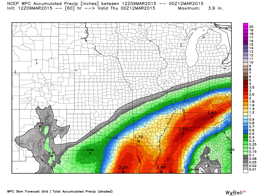
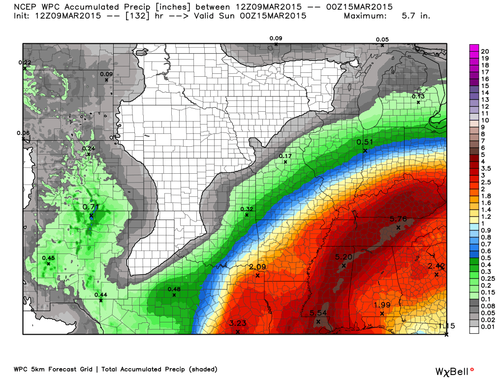
How much precipitation should we expect over the next few days?
This is round one. All of this falls through Tuesday afternoon
Then, let’s add in the next system. This is all of the rain from Tuesday through Saturday morning.
Not good news for the river basins.

I don’t have any winter weather in the forecast! Winning!
Jim Rasor has a new blog. Check it out when you have time http://mylocalweather.net/forum/home

This section of the blog is speculative forecast information. Because it is past the range of what meteorologists can forecast accurately, it should be considered speculation. Anything past day 5 is considered a long range forecast.
The big story in the long range forecast continues to be the potential for locally heavy rain on Thursday/Friday of this week. Rainfall totals may exceed 1″ in some areas. Some of the data indicates totals greater than 2″ will also be possible. A few thunderstorms could occur. Not expecting severe thunderstorms.
I continue to monitor the charts for another round of chilly/cold temperatures the week of the 20th. Another storm system move move out of Oklahoma and Arkansas during this time, as well. Hopefully just a cold rain. Will monitor and update as we move forward.
Check out the difference between this weeks temperature anomalies and the week of the 20th. The week of the 20th could bring record cold for some locations in the Ohio Valley.
These are in Celsius. Images from weatherbell.com
This week
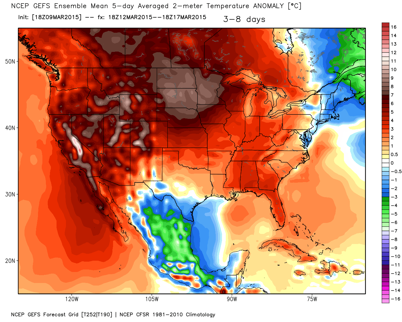
Week of the 20th
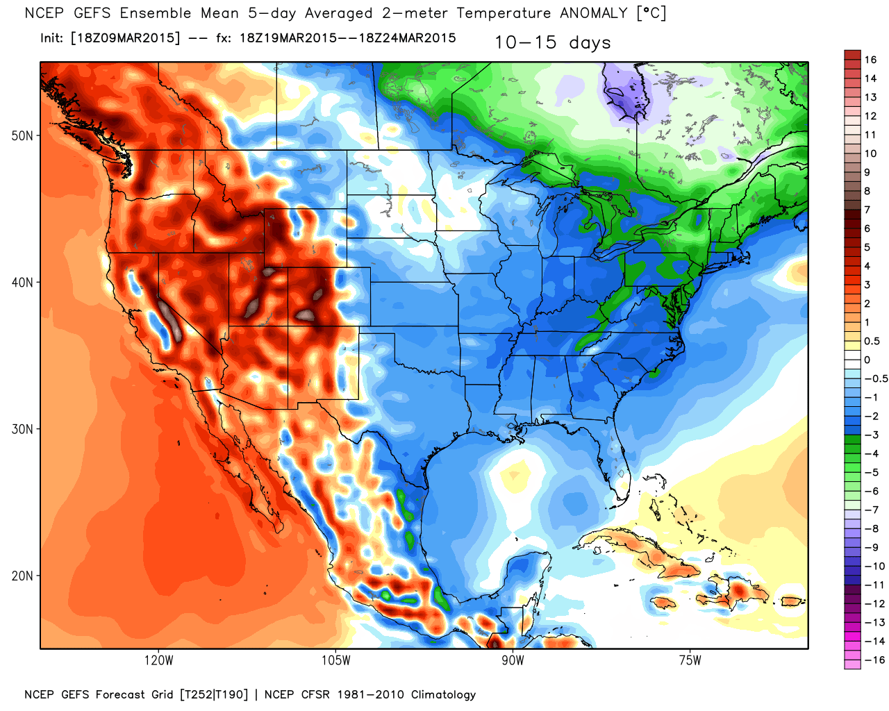
Monitor updates…the week of the 20th could be interesting
We have regional radars and local city radars – if a radar does not seem to be updating then try another one. Occasional browsers need their cache cleared. You may also try restarting your browser. That usually fixes the problem. Occasionally we do have a radar go down. That is why I have duplicates. Thus, if one fails then try another one.
If you have any problems then please send me an email beaudodson@usawx.com
WEATHER RADAR PAGE – Click here —
We also have a new national interactive radar – you can view that radar by clicking here.
Local interactive city radars include St Louis, Mt Vernon, Evansville, Poplar Bluff, Cape Girardeau, Marion, Paducah, Hopkinsville, Memphis, Nashville, Dyersburg, and all of eastern Kentucky – these are interactive radars. Local city radars – click here
NOTE: Occasionally you will see ground clutter on the radar (these are false echoes). Normally they show up close to the radar sites – including Paducah.
Regional Radar – Click on radar to take you our full radar page.


Regional Radar

Live Lightning Data – zoom and pan: Click here
Live Lightning Data with sound (click the sound button on the left side of the page): Click here
![]()
Current WARNINGS (a warning means take action now). Click on your county to drill down to the latest warning information. Keep in mind that there can be a 2-3 minute delay in the updated warning information.
I strongly encourage you to use a NOAA Weather Radio or warning cell phone app for the most up to date warning information. Nothing is faster than a NOAA weather radio.


Color shaded counties are under some type of watch, warning, advisory, or special weather statement. Click your county to view the latest information.

Missouri Warnings

Illinois Warnings

Kentucky Warnings

Please visit your local National Weather Service Office by clicking here. The National Weather Service Office, for our region, is located in Paducah, Kentucky. They have a lot of maps and information on their site. Local people…local forecasters who care about our region.


Who do you trust for your weather information and who holds them accountable?
I have studied weather in our region since the late 1970’s. I have 37 years of experience in observing our regions weather patterns. My degree is in Broadcast Meteorology from Mississippi State University and an Associate of Science (AS). I am currently working on my Bachelor’s Degree in Geoscience. Just need to finish two Spanish classes!
I am a member of the American Meteorological Society. I am a NOAA Weather-Ready Nation Ambassador. And, I am the Meteorologist for McCracken County Emergency Management.
I own and operate the Southern Illinois Weather Observatory.
There is a lot of noise on the internet. A lot of weather maps are posted without explanation. Over time you should learn who to trust for your weather information.
My forecast philosophy is simple and straight forward.
- Communicate in simple terms
- To be as accurate as possible within a reasonable time frame before an event
- Interact with you on Twitter, Facebook, and the blog
- Minimize the “hype” that you might see on television or through other weather sources
- Push you towards utilizing wall-to-wall LOCAL TV coverage during severe weather events
I am a recipient of the Mark Trail Award, WPSD Six Who Make A Difference Award, Kentucky Colonel, and the Caesar J. Fiamma” Award from the American Red Cross. In 2009 I was presented with the Kentucky Office of Highway Safety Award. I was recognized by the Kentucky House of Representatives for my service to the State of Kentucky leading up to several winter storms and severe weather outbreaks.
If you click on the image below you can read the Kentucky House of Representatives Resolution.

I am also President of the Shadow Angel Foundation which serves portions of western Kentucky and southern Illinois.
Many of my graphics are from www.weatherbell.com – a great resource for weather data, model data, and more


This blog was inspired by ABC 33/40’s Alabama Weather Blog – view their blog
Current tower cam view from the Weather Observatory- Click here for all cameras.

Southern Illinois Weather Observatory

The Weather Observatory

Southern Illinois Weather Observatory
WSIL TV 3 has a number of tower cameras. Click here for their tower camera page & Illinois Road Conditions

Marion, Illinois
WPSD TV 6 has a number of tower cameras. Click here for their tower camera page & Kentucky Road Conditions & Kentucky Highway and Interstate Cameras

Downtown Paducah, Kentucky
Benton, Kentucky Tower Camera – Click here for full view

Benton, Kentucky

I24 Paducah, Kentucky

I24 Mile Point 9 – Paducah, KY

I24 – Mile Point 3 Paducah, Kentucky

You can sign up for my AWARE email by clicking here I typically send out AWARE emails before severe weather, winter storms, or other active weather situations. I do not email watches or warnings. The emails are a basic “heads up” concerning incoming weather conditions.