We have some great sponsors for the Weather Talk Blog. Please let our sponsors know that you appreciate their support for the Weather Talk Blog.
Milner and Orr Funeral Home and Cremation Services located in Paducah, Kentucky and three other western Kentucky towns – at Milner and Orr they believe in families helping families. You can find Milner and Orr on Facebook, as well.
![]()
.

For all of your families eye care needs. Visit their web-site here. Or, you can also visit their Facebook page.
.

Best at Enabling Body Shop Profitability since 1996. Located In Paducah Kentucky and Evansville Indiana; serving all customers in between. They provide Customer Service, along with all the tools necessary for body shops to remain educated and competitive. Click the logo above for their main web-site. You can find McClintock Preferred Finishes on Facebook, as well

Expressway Carwash and Express Lube are a locally owned and operated full service Carwash and Lube established in 1987. We have been proudly serving the community for 29 years now at our Park Avenue location and 20 years at our Southside location. We have been lucky enough to partner with Sidecar Deli in 2015, which allows us to provide our customers with not only quality service, but quality food as well. . If you haven’t already, be sure to make Expressway your one stop shop, with our carwash, lube and deli. For hours of operation and pricing visit www.expresswashlube.com or Expressway Carwash on Facebook.
I have launched the new weather texting service! I could use your help. Be sure and sign up and fully support all of the weather data you see each day.
This is a monthly subscription service. Supporting this helps support everything else. The cost is $3 a month for one phone, $5 a month for three phones, and $10 a month for seven phones.
For more information visit BeauDodsonWeather.com
Or directly sign up at Weathertalk.com


This forecast update covers far southern Illinois, far southeast Missouri, and far western Kentucky. See the coverage map on the right side of the blog.
Remember that weather evolves. Check back frequently for updates, especially during active weather.

Weather Radars
WEATHER RADAR PAGE – Click here
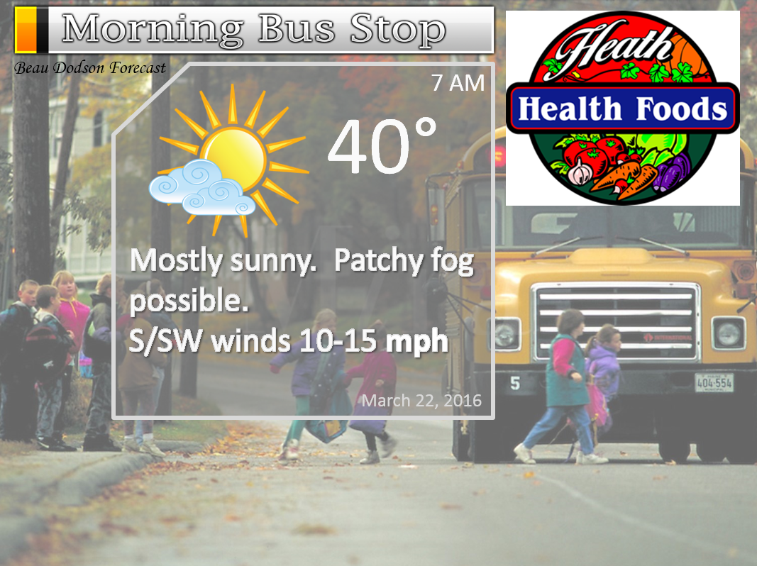
Monday Night – Mostly clear. Cool. Patchy fog possible.
Temperatures: Lows in the upper 30s to lower 40s. Temperatures may actually rise towards sunrise.
Winds: West/southwest winds at 6-12 mph. Increasing winds towards morning.
What is the chance for precipitation? 0%
Coverage of precipitation? None
My confidence in this part of the forecast verifying is High
Should I be concerned about snow or ice? No
Should I cancel my outdoor plans? No
Is severe weather expected? No
What impact is expected? None
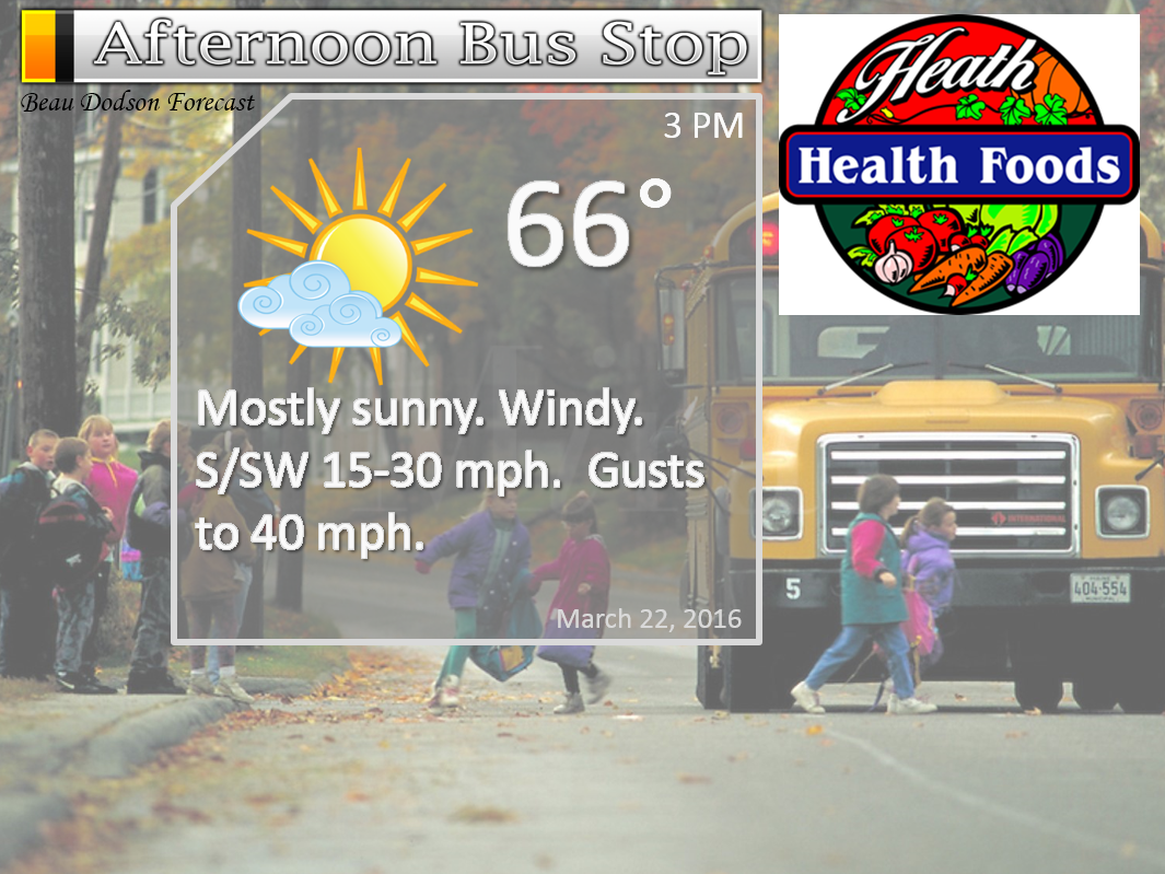
Tuesday – Perhaps patchy morning fog. Becoming mostly sunny. Warmer. Breezy.
Temperatures: High temperatures will range from 64-68 degrees.
Winds: Southwest winds at 10-20 mph with gusts to 30-40 mph.
What is the chance for precipitation? 0%
Coverage of precipitation? None
My confidence in this part of the forecast verifying is High
Should I be concerned about snow or ice? No
Should I cancel my outdoor plans? No.
Is severe weather expected? No
What impact is expected? Gusty winds.
Tuesday Night – Partly cloudy. Not as cool. Breezy.
Temperatures: Lows in the 50-55 degree range
Winds: Southwest winds at 10-20 mph. Gusty.
What is the chance for precipitation? 0%
Coverage of precipitation? None
My confidence in this part of the forecast verifying is High
Should I be concerned about snow or ice? No
Should I cancel my outdoor plans? No
Is severe weather expected? No
What impact is expected? Gusty winds.
Wednesday – Quite a few clouds. Mild. A few light rain showers possible. Gusty winds.
Temperatures: High temperatures will range from 65-70 degrees.
Winds: South/southwest winds at 10-20 mph with gusts above 25 mph.
What is the chance for precipitation? 30%
Coverage of precipitation? Isolated to perhaps scattered
My confidence in this part of the forecast verifying is Medium
Should I be concerned about snow or ice? No
Should I cancel my outdoor plans? No, but a few light showers possible
Is severe weather expected? No
What impact is expected? Gusty winds.
Wednesday Night – Cloudy. Increasing chances for showers and thunderstorms. Gusty winds likely. A strong storm or two possible.
Temperatures: Lows in the upper 50s to middle 60s
Winds: Southwest winds at 10-30 mph. Gusty. Winds may turn out of the west late at night.
What is the chance for precipitation? 80%
Coverage of precipitation? Widespread
My confidence in this part of the forecast verifying is High
Should I be concerned about snow or ice? No
Should I cancel my outdoor plans? No, but monitor radars
Is severe weather expected? Some strong storms can’t be ruled out. Risk of severe weather is fairly low.
What impact is expected? Gusty winds. Wet roadways. Lightning. A strong storm or two possible.
Thursday – Showers and thunderstorms likely during the first half of the day. Precipitation ending from west to east.
Temperatures: High temperatures in the middle to upper 50s behind the front. A few lower 60s ahead of the front. Front moves through the area during the morning and early afternoon hours.
Winds: Winds becoming westerly at 10-20 mph with gusts above 30 mph.
What is the chance for precipitation? 80% before noon and then diminishing to 20% after 3 pm. Front will sweep from west to east. Rain ends fairly soon once the front passes your area.
Coverage of precipitation? Widespread early and then becoming scattered during the afternoon.
My confidence in this part of the forecast verifying is High
Should I be concerned about snow or ice? No
Should I cancel my outdoor plans? Rain is a good bet early in the day and then diminishing chances as the day wears on. Ending first over southeast Missouri.
Is severe weather expected? Unlikely. But, monitor updates. A couple of strong storms can’t be ruled out.
What impact is expected? Lightning possible. Wet roadways. A strong storm or two possible.
Thursday Night – Some evening clouds. A chance for a rain or snow shower. Clearing as the night wears on. Colder.
Temperatures: Lows in the middle to upper 30s. If the winds die down then frost could occur.
Winds: West/northwest winds at 6-12 mph.
What is the chance for precipitation? 30% early
Coverage of precipitation? None to isolated
My confidence in this part of the forecast verifying is Medium
Should I be concerned about snow or ice? Nothing significant
Should I cancel my outdoor plans? No
Is severe weather expected? No
What impact is expected? None.
Friday – Partly sunny. Cooler.
Temperatures: High temperatures in the middle 50s
Winds: Northwest wind at 5 mph.
What is the chance for precipitation? 0%
Coverage of precipitation? None
My confidence in this part of the forecast verifying is High
Should I be concerned about snow or ice? No
Should I cancel my outdoor plans? No
Is severe weather expected? No
What impact is expected? None
Dry Saturday with temperatures into the upper 50s to middle 60s. Medium confidence.
A chance for rain showers on Sunday with temperatures in the middle to upper 60s. Rain chance 40%. Low confidence.
The School Bus Stop Forecast is sponsored by Heath Health and Wellness. Located next to Crowell Pools in Lone Oak.

Heath Health Foods is a locally owned and operated retail health and wellness store. Since opening in February 2006; the store has continued to grow as a ministry with an expanding inventory which also offers wellness appointments and services along with educational opportunities. Visit their web-site here. And. visit Heath Health Foods on Facebook!

Don’t forget to check out the Southern Illinois Weather Observatory web-site for weather maps, tower cams, scanner feeds, radars, and much more! Click here

An explanation of what is happening in the atmosphere over the coming days…
- Windy on Tuesday
- Showers and thunderstorms possible on Wednesday night/Thursday morning
- Dry on Friday
- Some clouds and showers possible Easter Sunday
The big weather story over the next few days will be a deep area of low pressure that will push across Kansas into Missouri and Iowa. The low will develop on Tuesday and Tuesday night. It will then push east/northeast on Wednesday into Thursday. The low will pass well to our north. This places our region in the mild air.
There will be a tight pressure gradient associated with this storm system. A tight pressure gradient means windy conditions. Winds will increase late Monday night and continue to increase on Tuesday. Expect wind gusts of 30-40 mph during the day on Tuesday. Then 15-25 mph on Tuesday night. Windy conditions will linger into Wednesday night and Thursday morning.
The southerly winds will help increase moisture, as well. Clouds will thicken on Wednesday and a few light rain showers will be possible. A widespread rain event will occur on Wednesday night and Thursday.
As the area of low pressure passes to our north on Wednesday night and Thursday a cold front will swing through our region. Showers and thunderstorms will develop on Wednesday afternoon from Iowa into Missouri and then into Oklahoma and Texas. This area of showers and thunderstorms will push eastward during the overnight hours on Wednesday. I am anticipating widespread rain in our region Wednesday night into Thursday morning.
The rain will end from west to east on Thursday. Lingering the longest over our eastern counties.
We may see some evening rain or snow showers as the system departs on Thursday evening.
Rainfall totals of 0.25″-0.50″ are likely with this system. And, locally higher totals are possible. Remember, thunderstorms can always produce higher totals.
The severe weather risk is not zero. But, the severe weather risk is not all that great. A few strong storms with small hail and gusty winds will be possible on both Wednesday night and Thursday morning. Perhaps a better chance for stronger storms over our western counties of southeast Missouri.
Instability with this system is not impressive. CAPE values of 100-500 will be possible. CAPE is a measure of potential energy in the atmosphere. Typically, this time of the year, one looks for readings of 500-2000. Once you reach those numbers the threat of severe weather increases.
We should dry out by Thursday afternoon into Thursday night. Again, the rain exits our eastern counties last.
Dry weather is likely on both Friday and Saturday. Another storm system approaches Saturday night into Easter Sunday. Rain showers will once again be possible during that time frame.
Easter Sunday will likely be cloudy with a chance for scattered showers. Still several days away. Hopefully the forecast will change.
Let’s take a look at some weather maps for our next storm system
I am showing you the NAM model guidance.
The overall end result is about the same for our region. Perhaps small changes in timing, but not much.
Either way we are on the warm side of this system. As the system pulls away, on Thursday afternoon, we could see some colder air wrap into the system. GFS?NAM models show some snow showers fairly far south on Thursday evening. I will keep an eye on that. Nothing significant expected.
These images are from weatherbell.com
This first image is for Wednesday afternoon. You can see heavy snow over Nebraska in the blue and purple. You can see some spotty light rain over our area. The green colors. Wednesday will deliver quite a few clouds. Gusty winds. Spotty light rain or drizzle.
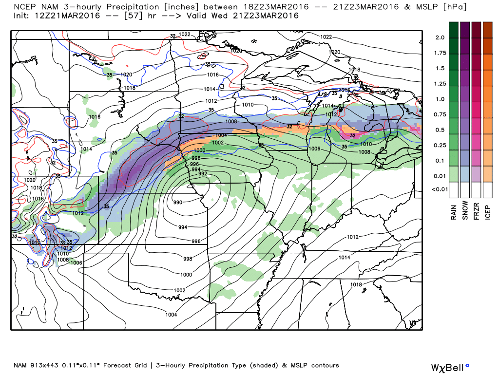
Here is the Wednesday evening map. You can see the area of low pressure over southern Iowa and northern Missouri. The closed isobars represent the area of low pressure. A cold front is draped from the low into Missouri and western Arkansas. Showers and thunderstorms along and ahead of the front. Green represents rain. Blue and purple represent snow. Purple being heavy snow.
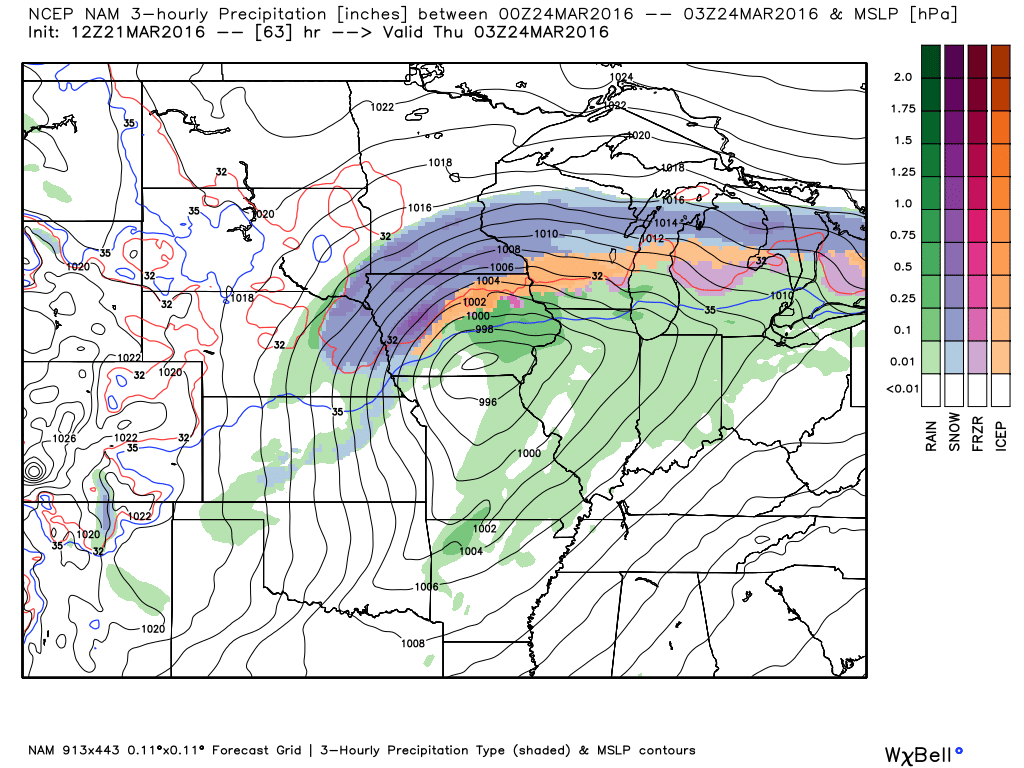
The low pushes into Illinois late Wednesday night. The cold front is draped across Missouri into Arkansas. It will push eastward overnight and into Thursday morning.
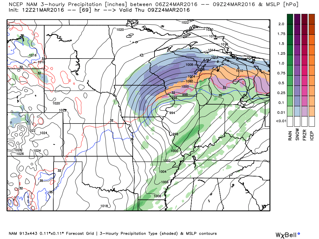
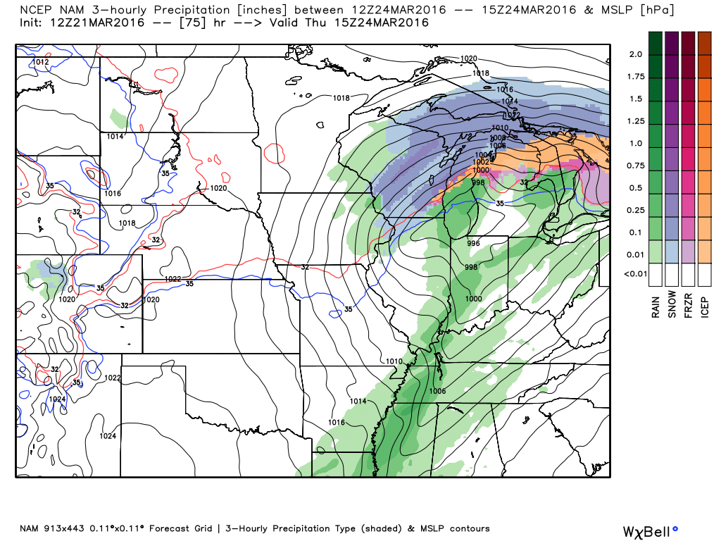
By Thursday morning the low has moved into northern Illinois. It continues to track northeast. The cold front will be sliding across our region on Thursday morning and afternoon. Showers and some thunderstorms along the front.
This next image shows you the weather map for 10 am on Thursday morning. It is showing showers and storms in our local area. Snow well to the north in Wisconsin. The low is now moving into southwest Michigan. Cold front slices across our region.
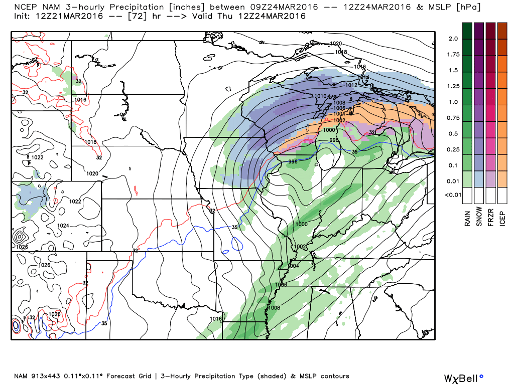
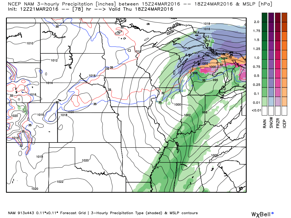
By 1 pm on Thursday the front has moved through most of our area. Showers and storms will continue for the eastern half of the area into early/mid afternoon.
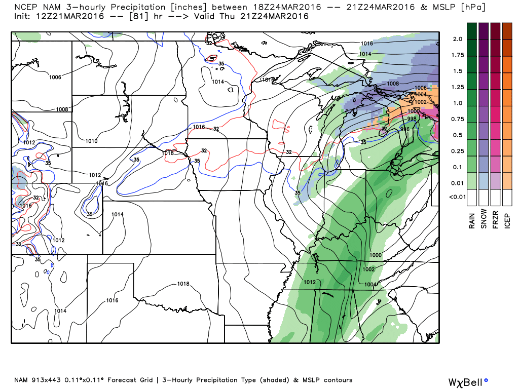
This next map is for Thursday around 4-5 pm. Rain continues to track eastward. Still some rain in our area. Thunderstorms, as well. Drying out from west to east. You can see the low over southwest Michigan.
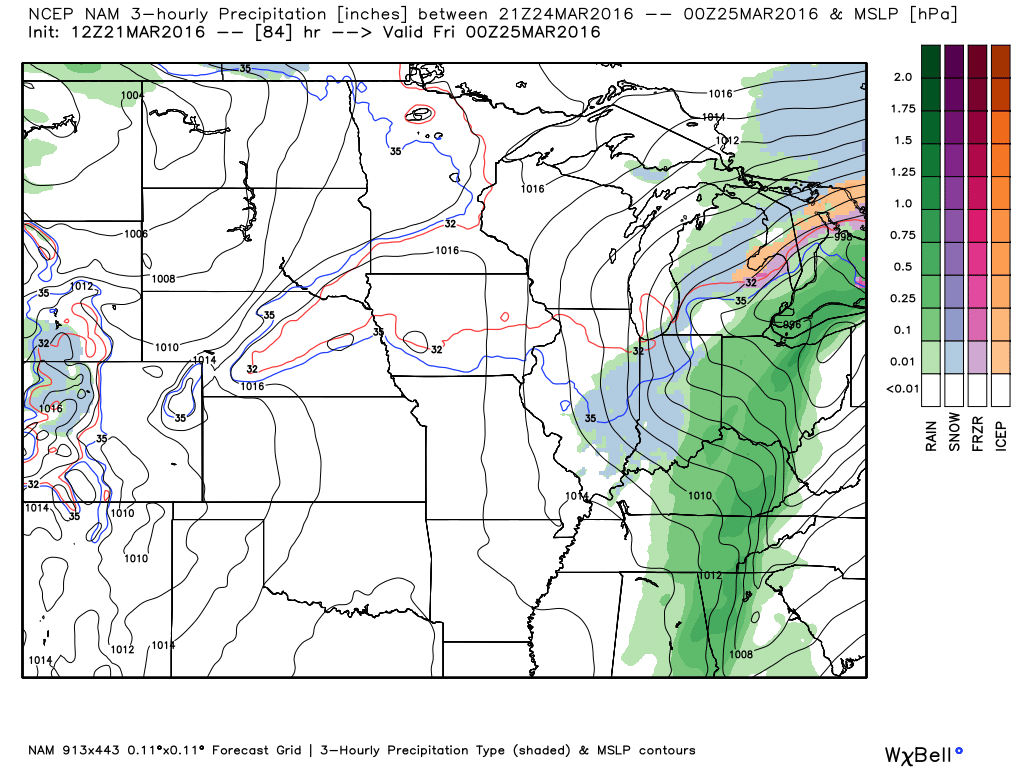
This last map is for Thursday evening at 7 pm. It does show some light rain or snow showers over parts of Illinois and Indiana (blue is snow and green represents rain). Dry for most of the area. Clouds will linger. Clearing late at night.

Here are the current river stage forecasts. You can click your state and then the dot for your location. It will bring up the full forecast and hydrograph.

Can we expect severe thunderstorms over the next 24 to 48 hours? Remember that a severe thunderstorm is defined as a thunderstorm that produces 58 mph winds or higher, quarter size hail or larger, and/or a tornado.
.
Thunderstorms are possible on Wednesday night and Thursday. A strong storm can’t be ruled out. Instability appears to be lacking. But, a strong cold front will at least provide the opportunity for lightning. Gusty winds near storms. Right now the severe weather threat appears low. I will continue to monitor and update.
.

No major changes in this forecast update.
.

No major concerns. Gusty winds on Tuesday and lightning possible Wednesday night/Thursday morning.

Windy conditions are Tuesday. We could see gusts over 30 mph.

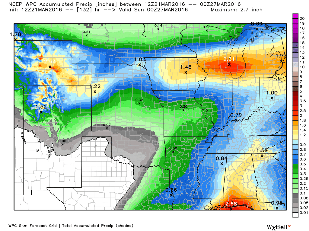
How much precipitation should we expect over the next few days?
Another rain maker Wednesday night/Thursday/Thursday night could produce some downpours.
Currently, this is the anticipated rainfall totals. This map has been shifting around quite a bit over the last few days.
Latest data shows 0.20″-0.50″. That is quite a bit lower than the thinking a few days

Here is the official 6-10 day and 8-14 day temperature and precipitation outlook. Check the date stamp at the top of each image (so you understand the time frame).
The forecast maps below are issued by the Weather Prediction Center (NOAA).


The latest 8-14 day temperature and precipitation outlook. Note the dates are at the top of the image. These maps DO NOT tell you how high or low temperatures or precipitation will be. They simply give you the probability as to whether temperatures or precipitation will be above or below normal.


Who do you trust for your weather information and who holds them accountable?
I have studied weather in our region since the late 1970’s. I have 37 years of experience in observing our regions weather patterns. My degree is in Broadcast Meteorology from Mississippi State University and an Associate of Science (AS). I am currently working on my Bachelor’s Degree in Geoscience.
My resume includes:
Member of the American Meteorological Society.
NOAA Weather-Ready Nation Ambassador.
Meteorologist for McCracken County Emergency Management. I served from 2005 through 2015.
I own and operate the Southern Illinois Weather Observatory.
Recipient of the Mark Trail Award, WPSD Six Who Make A Difference Award, Kentucky Colonel, and the Caesar J. Fiamma” Award from the American Red Cross.
In 2009 I was presented with the Kentucky Office of Highway Safety Award.
Recognized by the Kentucky House of Representatives for my service to the State of Kentucky leading up to several winter storms and severe weather outbreaks.
I am also President of the Shadow Angel Foundation which serves portions of western Kentucky and southern Illinois.
There is a lot of noise on the internet. A lot of weather maps are posted without explanation. Over time you should learn who to trust for your weather information.
My forecast philosophy is simple and straight forward.
- Communicate in simple terms
- To be as accurate as possible within a reasonable time frame before an event
- Interact with you on Twitter, Facebook, and the blog
- Minimize the “hype” that you might see on television or through other weather sources
- Push you towards utilizing wall-to-wall LOCAL TV coverage during severe weather events
I am a recipient of the Mark Trail Award, WPSD Six Who Make A Difference Award, Kentucky Colonel, and the Caesar J. Fiamma” Award from the American Red Cross. In 2009 I was presented with the Kentucky Office of Highway Safety Award. I was recognized by the Kentucky House of Representatives for my service to the State of Kentucky leading up to several winter storms and severe weather outbreaks.
If you click on the image below you can read the Kentucky House of Representatives Resolution.

Many of my graphics are from www.weatherbell.com – a great resource for weather data, model data, and more


You can sign up for my AWARE email by clicking here I typically send out AWARE emails before severe weather, winter storms, or other active weather situations. I do not email watches or warnings. The emails are a basic “heads up” concerning incoming weather conditions.