We have some great sponsors for the Weather Talk Blog. Please let our sponsors know that you appreciate their support for the Weather Talk Blog.
Milner and Orr Funeral Home and Cremation Services located in Paducah, Kentucky and three other western Kentucky towns – at Milner and Orr they believe in families helping families. You can find Milner and Orr on Facebook, as well.
![]()
.

For all of your families eye care needs. Visit their web-site here. Or, you can also visit their Facebook page.
.

Best at Enabling Body Shop Profitability since 1996. Located In Paducah Kentucky and Evansville Indiana; serving all customers in between. They provide Customer Service, along with all the tools necessary for body shops to remain educated and competitive. Click the logo above for their main web-site. You can find McClintock Preferred Finishes on Facebook, as well

Expressway Carwash and Express Lube are a locally owned and operated full service Carwash and Lube established in 1987. We have been proudly serving the community for 29 years now at our Park Avenue location and 20 years at our Southside location. We have been lucky enough to partner with Sidecar Deli in 2015, which allows us to provide our customers with not only quality service, but quality food as well. . If you haven’t already, be sure to make Expressway your one stop shop, with our carwash, lube and deli. For hours of operation and pricing visit www.expresswashlube.com or Expressway Carwash on Facebook.
I have launched the new weather texting service! I could use your help. Be sure and sign up and fully support all of the weather data you see each day.
This is a monthly subscription service. Supporting this helps support everything else. The cost is $3 a month for one phone, $5 a month for three phones, and $10 a month for seven phones.
For more information visit BeauDodsonWeather.com
Or directly sign up at Weathertalk.com


This forecast update covers far southern Illinois, far southeast Missouri, and far western Kentucky. See the coverage map on the right side of the blog.
Remember that weather evolves. Check back frequently for updates, especially during active weather.

Weather Radars
WEATHER RADAR PAGE – Click here
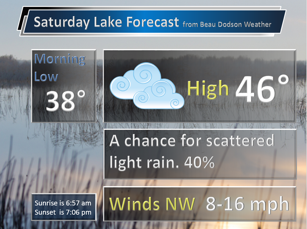
Sunday Night – Clearing and cold. Frost possible if winds die down. Freeze possible. Freeze conditions could occur in all of my forecast counties.
Temperatures: Lows in the 28-35 degree range.
Winds: West and northwest winds at 5 mph.
What is the chance for precipitation? 0%
Coverage of precipitation? None
My confidence in this part of the forecast verifying is High
Should I be concerned about snow or ice? No
Should I cancel my outdoor plans? No
Is severe weather expected? No
What impact is expected? Frost possible. Freeze possible.
Monday – Mostly sunny during the morning. Patchy fog may develop. Where fog develops you can expect a mix of sun and clouds. Cool.
Temperatures: High temperatures will range from 52-56 degrees.
Winds: West winds at 10 mph.
What is the chance for precipitation? 0%
Coverage of precipitation? None
My confidence in this part of the forecast verifying is High
Should I be concerned about snow or ice? No
Should I cancel my outdoor plans? No.
Is severe weather expected? No
What impact is expected? None
Monday Night – Mostly clear. Cool.
Temperatures: Lows in the upper 30s to lower 40s.
Winds: West/southwest winds at 6-12 mph.
What is the chance for precipitation? 0%
Coverage of precipitation? None
My confidence in this part of the forecast verifying is High
Should I be concerned about snow or ice? No
Should I cancel my outdoor plans? No
Is severe weather expected? No
What impact is expected? None
Tuesday – Mostly sunny. Warmer. Breezy.
Temperatures: High temperatures will range from 52-56 degrees.
Winds: Southwest winds at 10-20 mph with gusts over 30 mph likely.
What is the chance for precipitation? 0%
Coverage of precipitation? None
My confidence in this part of the forecast verifying is High
Should I be concerned about snow or ice? No
Should I cancel my outdoor plans? No.
Is severe weather expected? No
What impact is expected? Gusty winds.
Tuesday Night – Partly cloudy. Not as cool. Breezy.
Temperatures: Lows in the 53-56 degree range
Winds: Southwest winds at 10-20 mph. Gusty.
What is the chance for precipitation? 0%
Coverage of precipitation? None
My confidence in this part of the forecast verifying is High
Should I be concerned about snow or ice? No
Should I cancel my outdoor plans? No
Is severe weather expected? No
What impact is expected? Gusty winds.
Wednesday – Quite a few clouds. Mild. Small chance for a light rain shower. Gusty winds.
Temperatures: High temperatures will range from 64 to 68 degrees.
Winds: South/southwest winds at 10-20 mph with gusts above 30 mph.
What is the chance for precipitation? 10%
Coverage of precipitation? Isolated
My confidence in this part of the forecast verifying is Medium
Should I be concerned about snow or ice? No
Should I cancel my outdoor plans? No.
Is severe weather expected? No
What impact is expected? Gusty winds.
Wednesday Night – Cloudy. A good chance for showers and thunderstorms. Gusty winds likely.
Temperatures: Lows in the upper 50s to middle 60s
Winds: Southwest winds at 10-30 mph. Gusty. Winds may turn out of the west late at night.
What is the chance for precipitation? 70%
Coverage of precipitation? Scattered to widespread
My confidence in this part of the forecast verifying is High
Should I be concerned about snow or ice? No
Should I cancel my outdoor plans? No, but monitor radars
Is severe weather expected? Some strong storms can’t be ruled out.
What impact is expected? Gusty winds. Wet roadways. Lightning.
Thursday – Morning showers and thunderstorms ending. Cooler.
Temperatures: High temperatures in the 50s behind the front.
Winds: West winds at 10-20 mph with gusts above 30 mph.
What is the chance for precipitation? 60% before noon and then diminishing to 20% after noon. Front will sweep from west to east. Rain ends fairly soon once the front passes your area.
Coverage of precipitation? Scattered to widespread.
My confidence in this part of the forecast verifying is Medium
Should I be concerned about snow or ice? No
Should I cancel my outdoor plans? No, but monitor radars.
Is severe weather expected? Unlikely. But, monitor updates.
What impact is expected? Lightning possible. Wet roadways.
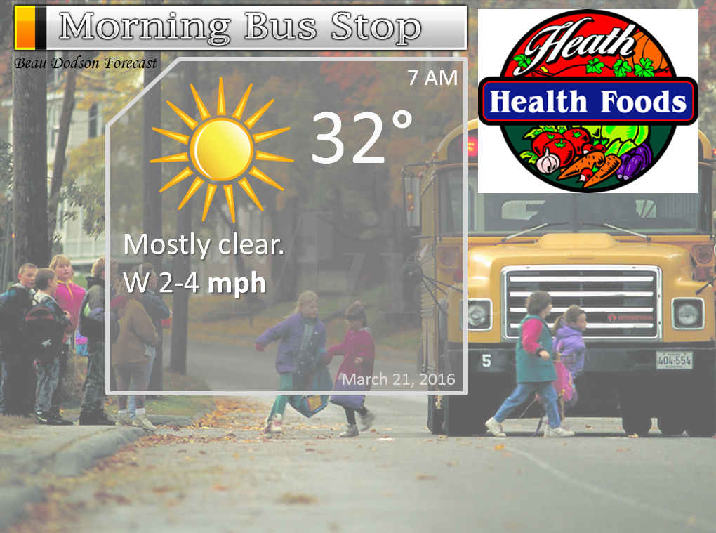
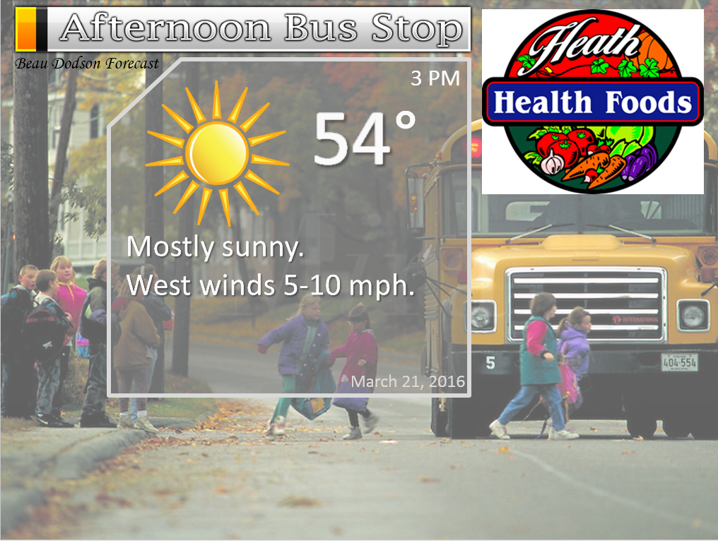
The School Bus Stop Forecast is sponsored by Heath Health and Wellness. Located next to Crowell Pools in Lone Oak.

Heath Health Foods is a locally owned and operated retail health and wellness store. Since opening in February 2006; the store has continued to grow as a ministry with an expanding inventory which also offers wellness appointments and services along with educational opportunities. Visit their web-site here. And. visit Heath Health Foods on Facebook!

Don’t forget to check out the Southern Illinois Weather Observatory web-site for weather maps, tower cams, scanner feeds, radars, and much more! Click here

An explanation of what is happening in the atmosphere over the coming days…
- Cold Sunday night with a chance for frost/freeze
- Mild by Tuesday.
- Windy Tuesday into Thursday.
- Thunderstorms possible Wednesday night and Thursday
The big weather story over the next 12 hours will be the cold temperatures. Overnight lows on Sunday night will dip into the upper 20s to lower 30s over most of our region. This will provide the opportunity for some frost and freeze conditions. Sensitive plants might be impacted by the cold temperatures.
The good news is that the cold snap will be short lived. Expect highs by Tuesday to reach into the 60s. Collective cheer! Welcome to spring 2016.
A tight pressure gradient will set up over our region on Tuesday and that could last into Thursday. That equals gusty winds. Winds above 30 mph will be possible Tuesday into Thursday.
A cold front will sweep through the region on Wednesday night and Thursday. An area of low pressure is forecast to move out of Kansas and Oklahoma on Wednesday. Pushing across Missouri, Illinois, and Iowa on Wednesday night. This will drag the cold front into our local area. Warm air will push northward ahead of the cold front.
There are a few ingredients lacking for a severe weather outbreak with this system. CAPE is one of them. CAPE is potential energy in the atmosphere. And, it appears CAPE numbers will be fairly low on Wednesday night and Thursday. Some thunderstorms will occur along the front, but severe storm risk appears small. We have been fortunate over the last few months. Very few severe weather reports in our region. We are starting the year off on the right foot. Let’s hope it continues.
From here until the middle of June we will be monitoring each system for the potential of severe weather. Many of our severe weather events occur in April, May, and June. Then again in late October and November.
Another missing ingredient will be deep moisture. Dew points will likely rise into the 50s on Wednesday and Wednesday night. Maybe lower 60s. Upper 50s and lower 60s normally are what I look for when forecasting severe weather. This event might be marginal when it comes to higher dew points. This is because of our current cold snap. Cold air will push all the way to the Gulf of Mexico over the next 24 hours.
The cold front will sweep through the region by Thursday afternoon and evening. Colder air is likely behind the system on Thursday night. Perhaps some more thirties.
I am watching a series of storm systems over the coming weeks. Another chance for showers and storms around Saturday night and Sunday. Low confidence on that event.
We will warm up in front of each system and cool down behind them. The charts still show quite a bit of cold air potential over the next two weeks. We may not be finished with below freezing readings.
Let’s take a look at some weather maps.
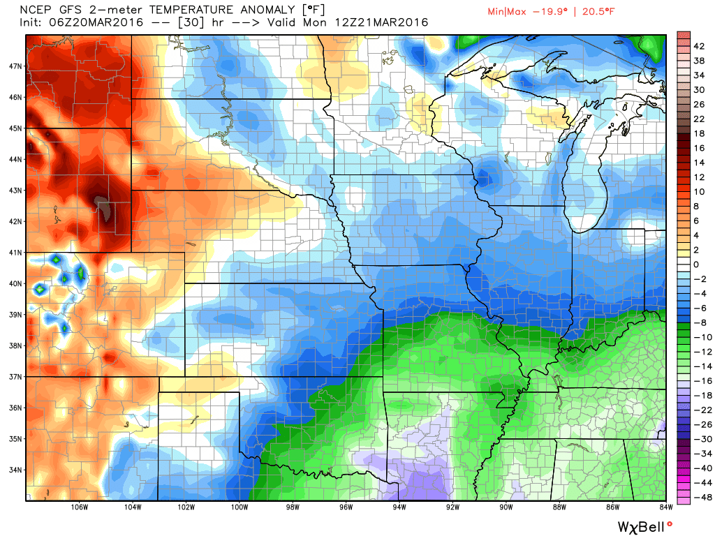
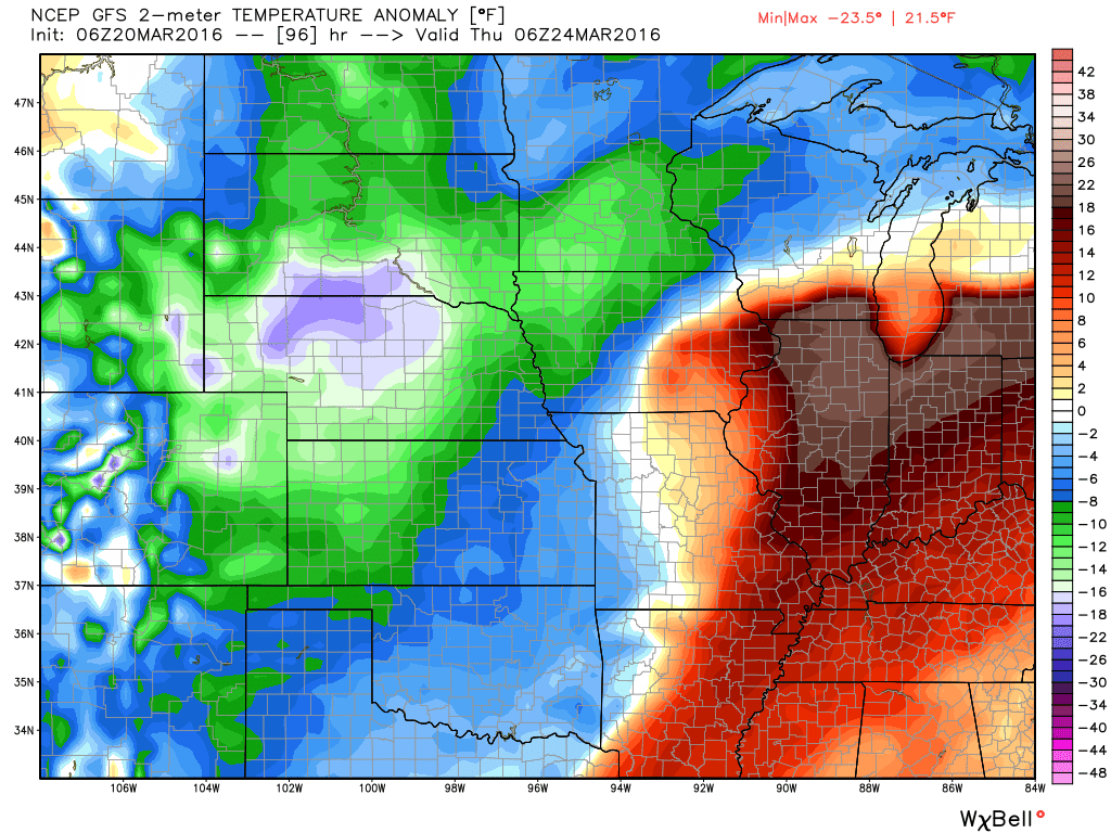
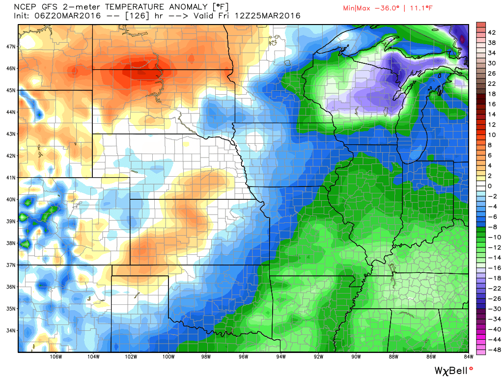
Let me show you the temperature anomaly maps for the next few days. How much above or below normal will temperatures be? Red and orange represents above normal. Blue and green represents below normal.
Normal high temperature for this time of the year are around 60 degrees.
Normal low temperatures for this time of the year are around 38-40 degrees.
This first map is for Monday morning. We are below normal. The green represents ten to fifteen degrees below normal.
Now, let’s move ahead to Wednesday night and Thursday morning. Notice the warm surge of air? That occurs ahead of our cold front. The low is well to our north. The low is helping to draw warm and moist air northward into our local area.
Moving ahead to Friday morning. This is behind the cold front. See how that works! We go back below normal. We warm up ahead of the fronts. We cool down behind the fronts.
Speaking of fronts.
Let’s look at the surface map for Wednesday into Thursday. This is our next storm system.
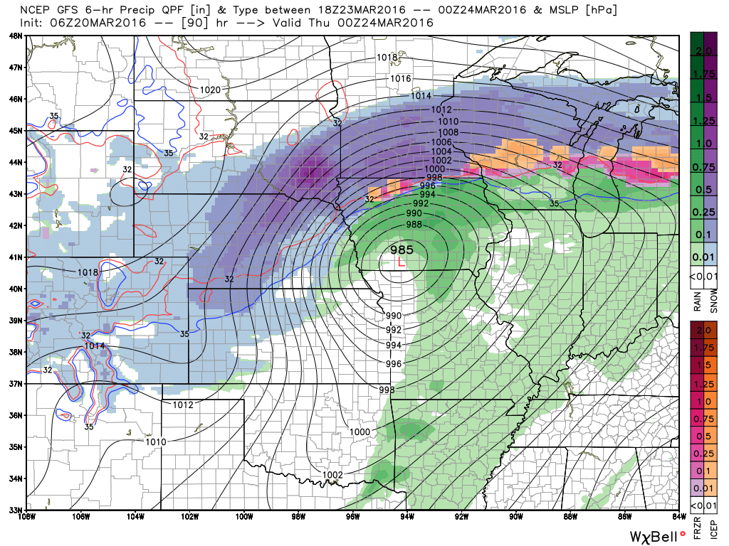
The GFS takes the low further north than the EC guidance. The EC guidance takes the low from central Missouri into central Illinois. The GFS takes the low into Iowa and northern Illinois.
This first map is for Wednesday evening at 7 pm. Look at the snowstorm well to our north. Heavy snow across parts of Iowa, South Dakota, Minnesota, and Wisconsin. This is the GFS model guidance. If the system is further south then the snow would be a little further south, as well. Not in our region. We will be in the warm sector of the storm. Deep low with this event. Expect the area of low pressure to drop into the upper 980s or lower 990s (millibars).
The GFS shows the low at 985 mb over southern Iowa at 7 pm on Wednesday evening. Tight isobars will produce strong and gusty winds for our region. Isobars are equal lines of pressure. Those are the circle lines you see around the area of low pressure. Tightly packed isobars would mean strong and gusty winds.
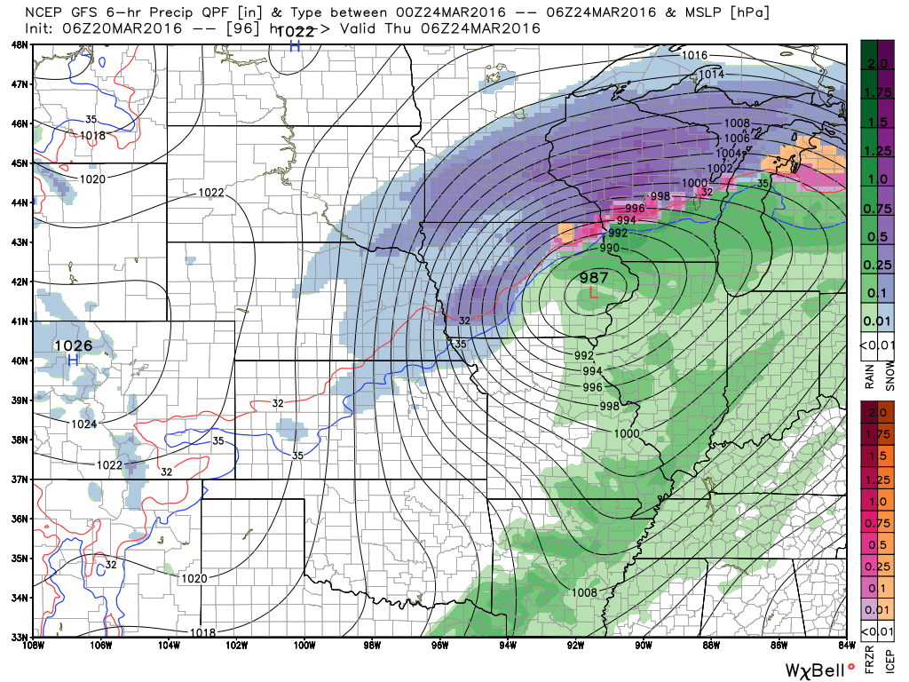
Moving ahead to later in the night. This is Thursday morning at 1 am. Low continue to track northeast. This would drag a cold front through our local area. Showers and storms ahead of the front.
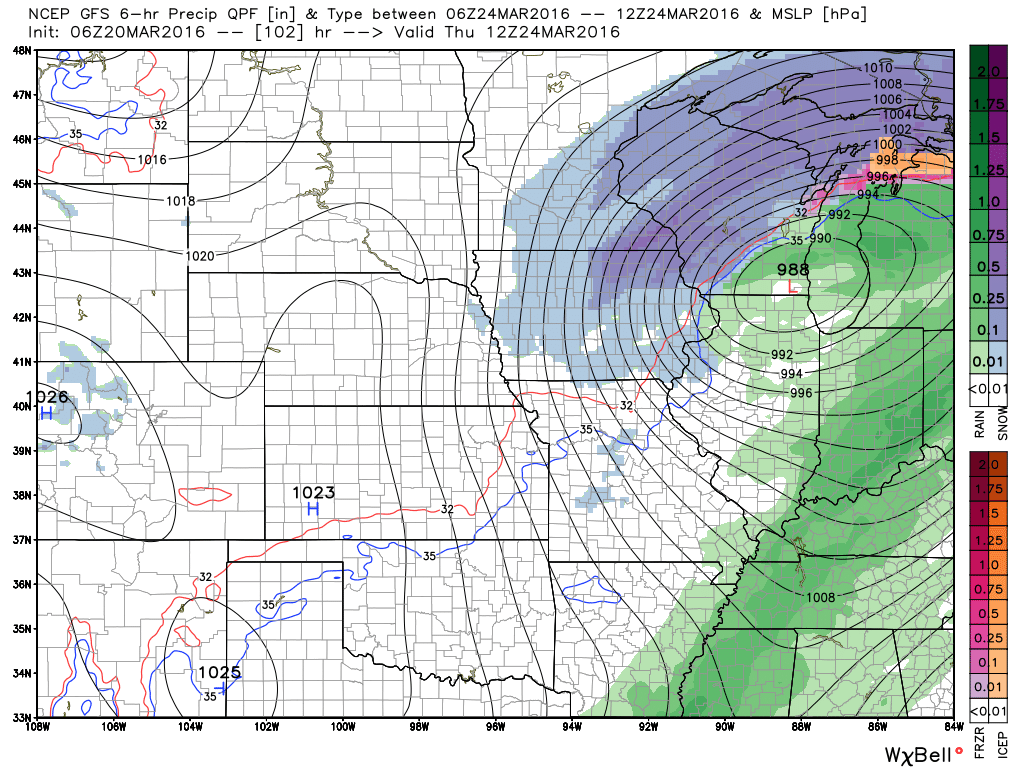
Finally, moving ahead to Thursday morning at 7 am. We still have some showers over our area. Perhaps some lightning, as well. Very heavy snow well to our north. Winter storm warnings will likely be needed with this event. Not sure about blizzard warnings. Certainly possible. Well to our north.
The front should pass through our region on Thursday morning. Heavier rain ahead of the front. Lighter rain immediately behind the front.
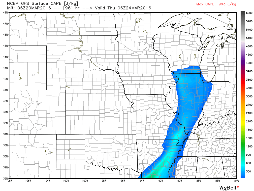
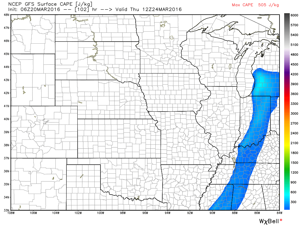
Here is the CAPE map for Wednesday night. A sliver of CAPE over our region. CAPE numbers are expected to be low. Whether this event can produce strong storms is questionable. If the CAPE numbers were higher then I would be more concerned. CAPE is potential energy for thunderstorms. The cold front would be right behind the blue colors. The colors represent CAPE numbers. Low numbers. Low is good.
Moving ahead to Thursday morning at 7 am. You can see CAPE numbers are still low. This, as the system pulls away. The cold front would be right behind the colors. The colors represent CAPE numbers. Low numbers. Low is good.
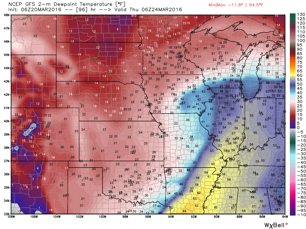
Let’s take a quick look at dew points. Dew point is a measure of moisture in the atmosphere. Dew point is better than using humidity when it comes to determining how much moisture is available for thunderstorms. Normally upper 50s and lower 60s+ are the numbers I look for when it comes to stronger storms. You can see a surge of higher dew points ahead of the cold front. You can mentally picture the area of low pressure over southern Iowa. The low rotates counter-clockwise. That means it would pull moisture northward from the Gulf of Mexico and then wrap it around itself. Southerly winds will be strong on Tuesday and Wednesday ahead of the system.
Plenty to monitor over the coming weeks. We are entering our stormy time of the year. Above normal precipitation appears likely over the coming 30 day period.

Here are the current river stage forecasts. You can click your state and then the dot for your location. It will bring up the full forecast and hydrograph.

Can we expect severe thunderstorms over the next 24 to 48 hours? Remember that a severe thunderstorm is defined as a thunderstorm that produces 58 mph winds or higher, quarter size hail or larger, and/or a tornado.
.
Thunderstorms are possible on Wednesday night and Thursday. A strong storm can’t be ruled out. Instability appears to be lacking. But, a strong cold front will at least provide the opportunity for lightning. Gusty winds near storms. Right now the severe weather threat appears low. I will continue to monitor and update.
.

Updated temperatures and wind speeds.
.

Frost is possible Sunday night. Freeze possible.

Frost and freeze conditions could harm sensitive plants on Sunday night.

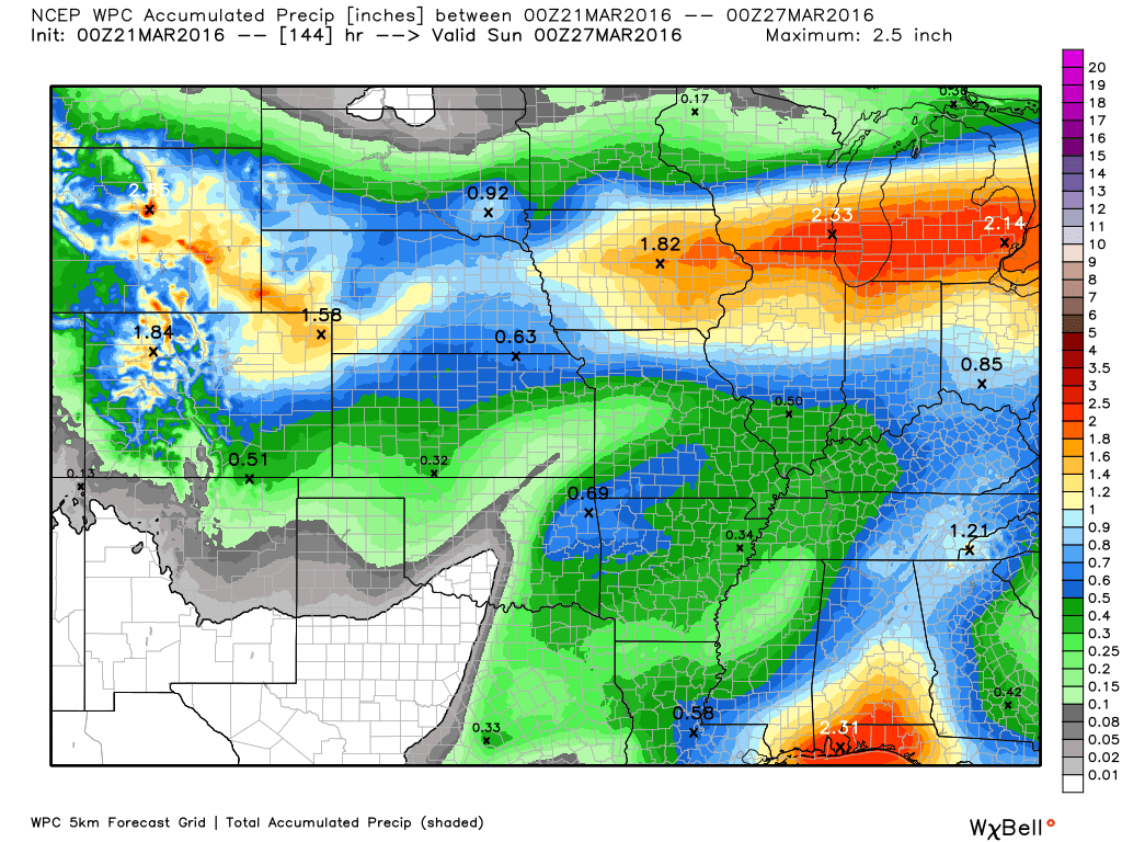
How much precipitation should we expect over the next few days?
Another rain maker Wednesday night/Thursday/Thursday night could produce some downpours.
Currently, this is the anticipated rainfall totals. This map has been shifting around quite a bit over the last few days.
NOAA updates this twice a day. At one time they had us in the 2-3″ rain totals. That has been reduced by quite a bit. Now the numbers are less than 0.50″.

Here is the official 6-10 day and 8-14 day temperature and precipitation outlook. Check the date stamp at the top of each image (so you understand the time frame).
The forecast maps below are issued by the Weather Prediction Center (NOAA).


The latest 8-14 day temperature and precipitation outlook. Note the dates are at the top of the image. These maps DO NOT tell you how high or low temperatures or precipitation will be. They simply give you the probability as to whether temperatures or precipitation will be above or below normal.


Who do you trust for your weather information and who holds them accountable?
I have studied weather in our region since the late 1970’s. I have 37 years of experience in observing our regions weather patterns. My degree is in Broadcast Meteorology from Mississippi State University and an Associate of Science (AS). I am currently working on my Bachelor’s Degree in Geoscience.
My resume includes:
Member of the American Meteorological Society.
NOAA Weather-Ready Nation Ambassador.
Meteorologist for McCracken County Emergency Management. I served from 2005 through 2015.
I own and operate the Southern Illinois Weather Observatory.
Recipient of the Mark Trail Award, WPSD Six Who Make A Difference Award, Kentucky Colonel, and the Caesar J. Fiamma” Award from the American Red Cross.
In 2009 I was presented with the Kentucky Office of Highway Safety Award.
Recognized by the Kentucky House of Representatives for my service to the State of Kentucky leading up to several winter storms and severe weather outbreaks.
I am also President of the Shadow Angel Foundation which serves portions of western Kentucky and southern Illinois.
There is a lot of noise on the internet. A lot of weather maps are posted without explanation. Over time you should learn who to trust for your weather information.
My forecast philosophy is simple and straight forward.
- Communicate in simple terms
- To be as accurate as possible within a reasonable time frame before an event
- Interact with you on Twitter, Facebook, and the blog
- Minimize the “hype” that you might see on television or through other weather sources
- Push you towards utilizing wall-to-wall LOCAL TV coverage during severe weather events
I am a recipient of the Mark Trail Award, WPSD Six Who Make A Difference Award, Kentucky Colonel, and the Caesar J. Fiamma” Award from the American Red Cross. In 2009 I was presented with the Kentucky Office of Highway Safety Award. I was recognized by the Kentucky House of Representatives for my service to the State of Kentucky leading up to several winter storms and severe weather outbreaks.
If you click on the image below you can read the Kentucky House of Representatives Resolution.

Many of my graphics are from www.weatherbell.com – a great resource for weather data, model data, and more


You can sign up for my AWARE email by clicking here I typically send out AWARE emails before severe weather, winter storms, or other active weather situations. I do not email watches or warnings. The emails are a basic “heads up” concerning incoming weather conditions.