We have some great sponsors for the Weather Talk Blog. Please let our sponsors know that you appreciate their support for the Weather Talk Blog.
Milner and Orr Funeral Home and Cremation Services located in Paducah, Kentucky and three other western Kentucky towns – at Milner and Orr they believe in families helping families. You can find Milner and Orr on Facebook, as well.
![]()
.

For all of your families eye care needs. Visit their web-site here. Or, you can also visit their Facebook page.
.

Best at Enabling Body Shop Profitability since 1996. Located In Paducah Kentucky and Evansville Indiana; serving all customers in between. They provide Customer Service, along with all the tools necessary for body shops to remain educated and competitive. Click the logo above for their main web-site. You can find McClintock Preferred Finishes on Facebook, as well

Expressway Carwash and Express Lube are a locally owned and operated full service Carwash and Lube established in 1987. We have been proudly serving the community for 29 years now at our Park Avenue location and 20 years at our Southside location. We have been lucky enough to partner with Sidecar Deli in 2015, which allows us to provide our customers with not only quality service, but quality food as well. . If you haven’t already, be sure to make Expressway your one stop shop, with our carwash, lube and deli. For hours of operation and pricing visit www.expresswashlube.com or Expressway Carwash on Facebook.
I have launched the new weather texting service! I could use your help. Be sure and sign up and fully support all of the weather data you see each day.
This is a monthly subscription service. Supporting this helps support everything else. The cost is $3 a month for one phone, $5 a month for three phones, and $10 a month for seven phones.
For more information visit BeauDodsonWeather.com
Or directly sign up at Weathertalk.com


This forecast update covers far southern Illinois, far southeast Missouri, and far western Kentucky. See the coverage map on the right side of the blog.
Remember that weather evolves. Check back frequently for updates, especially during active weather.

Weather Radars
WEATHER RADAR PAGE – Click here
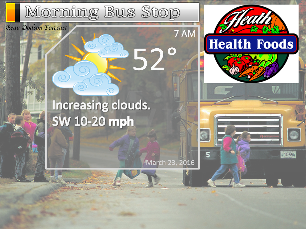
Tuesday Night – Partly cloudy. Not as cool. Breezy.
Temperatures: Lows in the 50-55 degree range
Winds: Southwest winds at 10-20 mph. Gusty.
What is the chance for precipitation? 0%
Coverage of precipitation? None
My confidence in this part of the forecast verifying is High
Should I be concerned about snow or ice? No
Should I cancel my outdoor plans? No
Is severe weather expected? No
What impact is expected? Gusty winds.
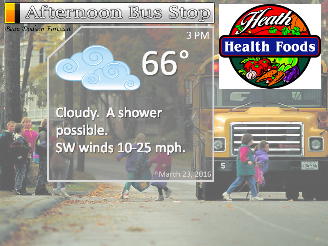
Wednesday – Quite a few clouds. Mild. A few light rain showers possible. Gusty winds.
Temperatures: High temperatures will range from 65-70 degrees.
Winds: South/southwest winds at 10-20 mph with gusts above 25 mph.
What is the chance for precipitation? 30%
Coverage of precipitation? Isolated to perhaps scattered
My confidence in this part of the forecast verifying is Medium
Should I be concerned about snow or ice? No
Should I cancel my outdoor plans? No, but a few light showers possible
Is severe weather expected? No
What impact is expected? Gusty winds. Perhaps some wet roadways.
Wednesday Night – Cloudy. Increasing chances for showers and thunderstorms as the night wears on. Gusty winds likely. A strong storm or two possible.
Temperatures: Lows in the upper 50s to middle 60s
Winds: Southwest winds at 10-30 mph. Gusty.
What is the chance for precipitation? 40% before 11 pm and then 80% after 11 pm
Coverage of precipitation? Becoming widespread late at night
My confidence in this part of the forecast verifying is High
Should I be concerned about snow or ice? No
Should I cancel my outdoor plans? No, but monitor radars
Is severe weather expected? Some strong storms can’t be ruled out. Risk of severe weather is fairly low, but not zero.
What impact is expected? Gusty winds. Wet roadways. Lightning. A strong storm or two possible.
Thursday – Showers and thunderstorms likely during the first half of the day. Precipitation ending from west to east as the day wears on. Best chances for precipitation before 1 pm.
Temperatures: High temperatures in the middle to upper 50s behind the front. A few lower 60s ahead of the front. Front moves through the area during the morning and early afternoon hours.
Winds: Winds becoming west/northwest at 10-20 mph with gusts above 30 mph.
What is the chance for precipitation? 80% before 1 pm and then diminishing to 20% after 1 pm. Front will sweep through the area from west to east. Rain ends fairly soon once the front passes your area.
Coverage of precipitation? Widespread early and then becoming scattered during the afternoon.
My confidence in this part of the forecast verifying is High
Should I be concerned about snow or ice? No
Should I cancel my outdoor plans? Rain is a good bet early in the day and then diminishing chances as the day wears on. Ending first over southeast Missouri. Ending last over the Pennyrile area of western Kentucky.
Is severe weather expected? Monitor updates. A couple of strong storms can’t be ruled out.
What impact is expected? Lightning possible. Wet roadways. A strong storm or two possible with gusty winds and small hail.
Thursday Night – Some evening clouds. Small chance for a shower. Clearing sky conditions overnight. Cold.
Temperatures: Lows in the lower to middle 30s.
Winds: West/northwest winds at 6-12 mph.
What is the chance for precipitation? 20% early
Coverage of precipitation? None to isolated
My confidence in this part of the forecast verifying is High
Should I be concerned about snow or ice? Nothing significant
Should I cancel my outdoor plans? No
Is severe weather expected? No
What impact is expected? None.
Friday – Partly sunny. Cooler.
Temperatures: High temperatures in the middle 50s
Winds: Northwest wind at 5 mph.
What is the chance for precipitation? 0%
Coverage of precipitation? None
My confidence in this part of the forecast verifying is High
Should I be concerned about snow or ice? No
Should I cancel my outdoor plans? No
Is severe weather expected? No
What impact is expected? None
Friday Night – Mostly clear. Chilly. Small chance for frost.
Temperatures: Lows in the middle to upper 30s
Winds: Southeast winds at 5 mph.
What is the chance for precipitation? 0%
Coverage of precipitation? None
My confidence in this part of the forecast verifying is High
Should I be concerned about snow or ice? No
Should I cancel my outdoor plans? No
Is severe weather expected? No
What impact is expected? None.
Saturday – Mostly sunny and mild. Nice day anticipated for outdoor activities.
Temperatures: High temperatures in the middle 60s
Winds: South and southeast winds at 8-16 mph.
What is the chance for precipitation? 0%
Coverage of precipitation? None
My confidence in this part of the forecast verifying is High
Should I be concerned about snow or ice? No
Should I cancel my outdoor plans? No
Is severe weather expected? No
What impact is expected? None
Saturday Night – Increasing clouds. Slight chance for a shower late at night.
Temperatures: Lows in the upper 40s to lower 50s
Winds: South/southeast winds at 5-10 mph
What is the chance for precipitation? 20%
Coverage of precipitation? Isolated
My confidence in this part of the forecast verifying is High
Should I be concerned about snow or ice? No
Should I cancel my outdoor plans? No
Is severe weather expected? No
What impact is expected? Maybe some wet roadways.
Sunday – Cloudy. A chance for showers. A thunderstorm possible. Low confidence on the thunderstorm part of the forecast. Higher confidence on some showers.
Temperatures: High temperatures middle 60s
Winds: Southwest winds at 10 mph.
What is the chance for precipitation? 40%-50%
Coverage of precipitation? Scattered
My confidence in this part of the forecast verifying is Medium
Should I be concerned about snow or ice? No
Should I cancel my outdoor plans? No, but some showers are possible. Monitor updates if you have outdoor events.
Is severe weather expected? No
What impact is expected? Lightning. Wet roadways.
The School Bus Stop Forecast is sponsored by Heath Health and Wellness. Located next to Crowell Pools in Lone Oak, Kentucky.
Visit their web-site here. And. visit Heath Health Foods on Facebook!
The School Bus Stop Forecast is sponsored by Heath Health and Wellness. Located next to Crowell Pools in Lone Oak.

Heath Health Foods is a locally owned and operated retail health and wellness store. Since opening in February 2006; the store has continued to grow as a ministry with an expanding inventory which also offers wellness appointments and services along with educational opportunities. Visit their web-site here. And. visit Heath Health Foods on Facebook!

Don’t forget to check out the Southern Illinois Weather Observatory web-site for weather maps, tower cams, scanner feeds, radars, and much more! Click here

An explanation of what is happening in the atmosphere over the coming days…
- Windy
- A light shower possible on Wednesday
- Showers and thunderstorms increasingly likely on Wednesday night/Thursday morning
- Dry Friday and Saturday
- Showers again possible by Sunday
Weather Radars
WEATHER RADAR PAGE – Click here
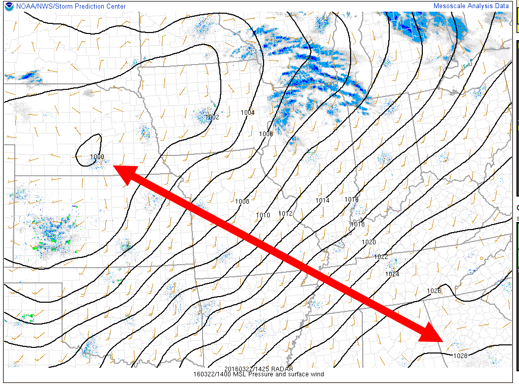
I hope you were not flying a kite today. I figure your kite is long gone by now! Winds of 30-45 mph were reported across much of the region on Tuesday afternoon. March winds.
The winds are in response to a tightening pressure gradient over our local area. Low pressure to our north and high pressure to our south. We are squeezed in the middle. Tight isobars equal strong and gusty winds.
Here is a look at the pressure gradient map. Note the low pressure over Nebraska. High pressure over the southeast United States. Tight gradient over our local area.
Clouds will increase on Wednesday and a few light showers will be possible as moisture increases on southerly winds. A cold front will push into our region on Wednesday night and Thursday morning. Timing this front has been a bit of a problem over the last few days. Some of the data wants to bring the front in earlier vs later.
At this time, it appears the cold front will push into southeast Missouri late Wednesday night and early Thursday morning. Showers and thunderstorms will develop along the front. The precipitation will first move into southeast Missouri and then spread eastward.
The best chance for showers and storms will be after midnight on Wednesday night and before 11 am on Thursday morning. Again, ending from west to east during the day on Thursday. Precipitation will linger the longest over the Pennyrile area of western Kentucky.
Instability is lacking with this system. However, wind fields aloft are going to be strong. A bit of a balancing act when it comes to the severe weather risk. If instability were greater then I would be more concerned. As it stands, a few storms could be intense. Strong winds, frequent lightning, and small hail can’t be ruled out. The severe weather risk isn’t great, but it isn’t zero. A few storms could approach severe levels. Thus, leave your weather radios on during Wednesday night and Thursday.
The front will sweep eastward during the day on Thursday. This will shut down the precipitation chances. Our winds will switch to the west/northwest and cooler weather will return.
Colder weather is anticipated on Thursday and Friday night. Lows will dip into the 30s. Winds should prevent widespread frost. We will need to monitor for a freeze on Friday night. Right now it appears temperatures might stay just above freezing for most of the area. Monitor updates if you have concerns.
We will warm back up on Saturday and Sunday. Saturday is the pick day of the weekend. Expect high temperatures in the 60s both days. Clouds and showers could be an issue on Sunday. There remain some questions as to coverage of the precipitation for Sunday. I know many of you have outdoor events. Monitor forecast updates.
Let’s look at some maps
These images are from weatherbell.com and this the NAM model guidance
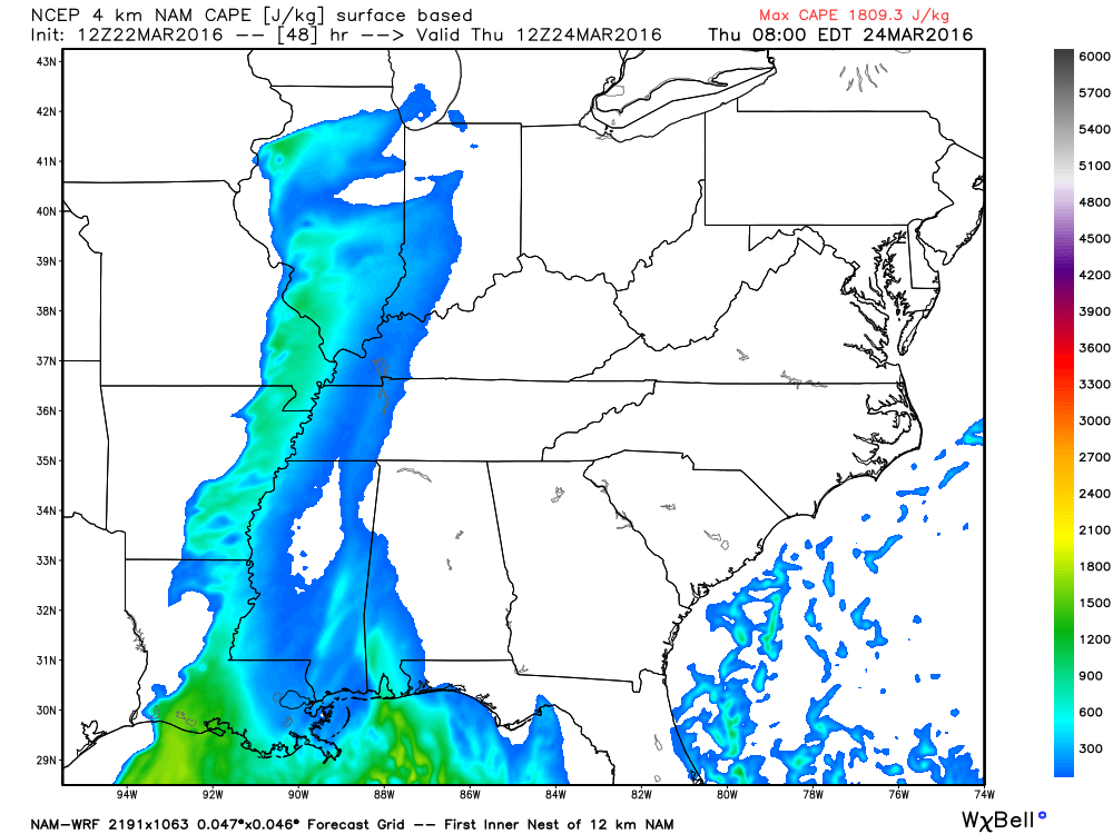
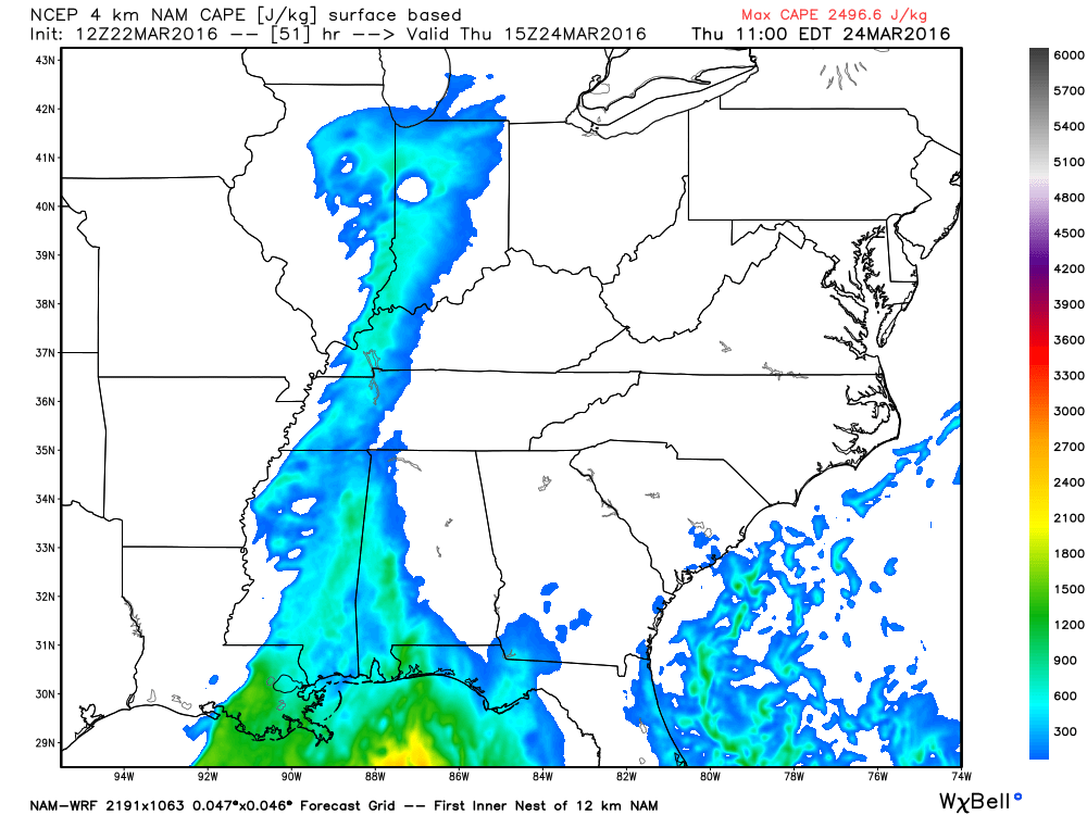
These first two maps are CAPE. CAPE is available potential energy for thunderstorms. These numbers have gone up a little bit. Higher numbers represent a greater risk for severe weather. I can’t rule out some intense storms late Wednesday night and Thursday morning. This will need to be monitored.
This first image is for 7 am on Wednesday morning. The cold front is pushing eastward into the area. Where the color ends is where the front is located (west side of the blue color zone).
This image is for 10 am on Wednesday morning. Front is moving eastward.
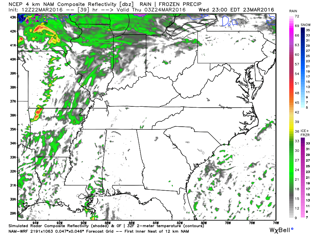
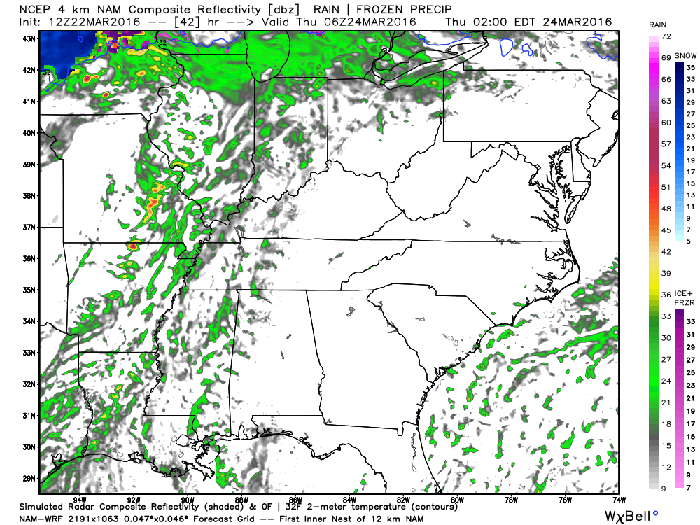
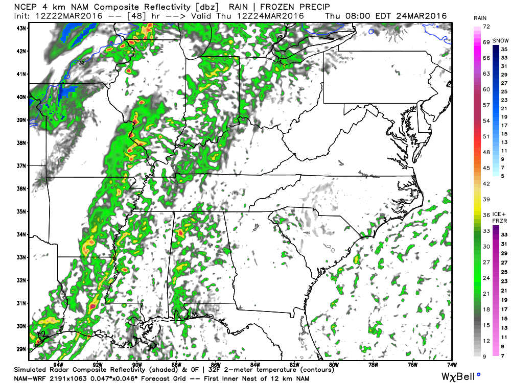
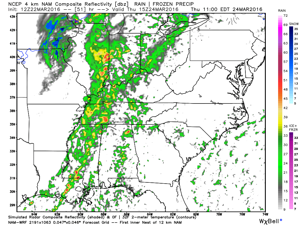
Let’s take a look at some radar images.
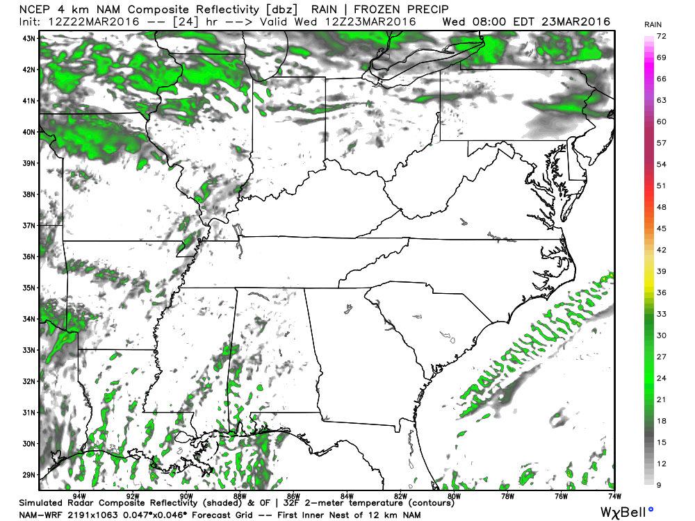
This is the future-cast radar. What radar might look like. Green represents rain showers.
This first image is for 7 am on Wednesday morning. A few showers possible. Light.
This next image is for 10 pm on Wednesday evening. See the line developing from northern Missouri into western Arkansas? That is the cold front. Brighter colors represent thunderstorms.
This next image is for 1 am on Thursday morning. The front is shifting eastward. Some thunderstorms along and ahead of the front.
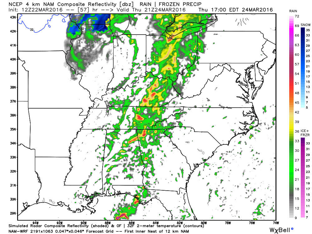
This next image is for 7 am on Thursday morning. The front is pushing through eastern Missouri. Showers and thunderstorms along and ahead of the front. Some strong storms possible.
This next image is for 10 am on Thursday morning. The front is pushing eastward. Rain has ended over our western counties. Rain continues elsewhere.
This next image is for 4 pm on Thursday afternoon. Most of the rain has ended. Note the snow over northern Illinois in blue.
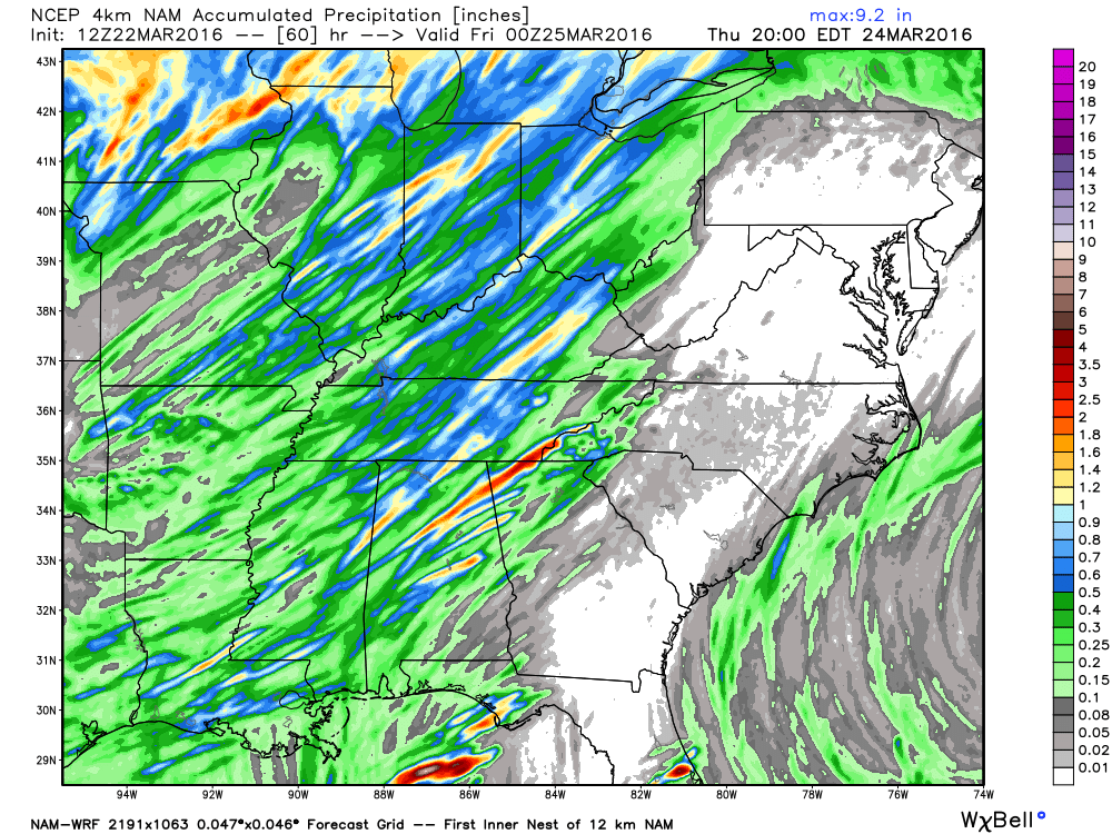
Here are the projected rainfall totals from the NAM/WRF model guidance. Those streaks represent thunderstorms. Pockets of heavier totals. Widespread 0.25″-0.50″ expected. Pockets of greater than 0.50″.
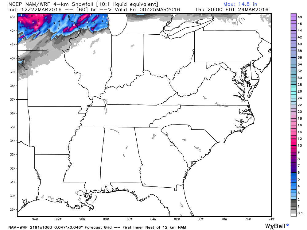
Snowfall totals. Snow well to our north. Heavy snow for some areas.
Weather Radars
WEATHER RADAR PAGE – Click here

Here are the current river stage forecasts. You can click your state and then the dot for your location. It will bring up the full forecast and hydrograph.

Can we expect severe thunderstorms over the next 24 to 48 hours? Remember that a severe thunderstorm is defined as a thunderstorm that produces 58 mph winds or higher, quarter size hail or larger, and/or a tornado.
.
Thunderstorms are possible on Wednesday night and Thursday. A few of the storms could be on the strong side with lightning, gusty winds, and small hail. Storms may approach severe levels. A severe thunderstorm is one that produces 1″ hail, 58 mph winds, and/or a tornado. The severe weather risk with this event is small, but not zero.
The thunderstorm risk for Friday and Saturday will be zero.
Monitoring Sunday for some showers and perhaps thunderstorms. Low confidence.
.

No major changes in this forecast update.
.

I am monitoring Wednesday night and Thursday morning for a few strong storms.

Some storms possible on Wednesday night and Thursday morning. Lightning, strong gusty winds, and even small hail will be possible.

How much precipitation should we expect over the next few days?
A few light showers are possible on Wednesday, but not expecting much in the way of totals. Perhaps a trace to 0.10″
A heavier rain event is possible Wednesday night and Thursday. Expect rainfall totals of 0.25″-0.50″. Locally higher totals are possible in thunderstorms.
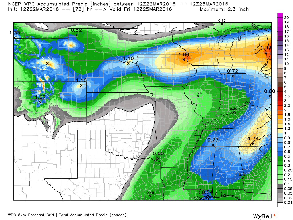
Here is the latest rainfall outlook through Thursday.

Here is the official 6-10 day and 8-14 day temperature and precipitation outlook. Check the date stamp at the top of each image (so you understand the time frame).
The forecast maps below are issued by the Weather Prediction Center (NOAA).


The latest 8-14 day temperature and precipitation outlook. Note the dates are at the top of the image. These maps DO NOT tell you how high or low temperatures or precipitation will be. They simply give you the probability as to whether temperatures or precipitation will be above or below normal.


Who do you trust for your weather information and who holds them accountable?
I have studied weather in our region since the late 1970’s. I have 37 years of experience in observing our regions weather patterns. My degree is in Broadcast Meteorology from Mississippi State University and an Associate of Science (AS). I am currently working on my Bachelor’s Degree in Geoscience.
My resume includes:
Member of the American Meteorological Society.
NOAA Weather-Ready Nation Ambassador.
Meteorologist for McCracken County Emergency Management. I served from 2005 through 2015.
I own and operate the Southern Illinois Weather Observatory.
Recipient of the Mark Trail Award, WPSD Six Who Make A Difference Award, Kentucky Colonel, and the Caesar J. Fiamma” Award from the American Red Cross.
In 2009 I was presented with the Kentucky Office of Highway Safety Award.
Recognized by the Kentucky House of Representatives for my service to the State of Kentucky leading up to several winter storms and severe weather outbreaks.
I am also President of the Shadow Angel Foundation which serves portions of western Kentucky and southern Illinois.
There is a lot of noise on the internet. A lot of weather maps are posted without explanation. Over time you should learn who to trust for your weather information.
My forecast philosophy is simple and straight forward.
- Communicate in simple terms
- To be as accurate as possible within a reasonable time frame before an event
- Interact with you on Twitter, Facebook, and the blog
- Minimize the “hype” that you might see on television or through other weather sources
- Push you towards utilizing wall-to-wall LOCAL TV coverage during severe weather events
I am a recipient of the Mark Trail Award, WPSD Six Who Make A Difference Award, Kentucky Colonel, and the Caesar J. Fiamma” Award from the American Red Cross. In 2009 I was presented with the Kentucky Office of Highway Safety Award. I was recognized by the Kentucky House of Representatives for my service to the State of Kentucky leading up to several winter storms and severe weather outbreaks.
If you click on the image below you can read the Kentucky House of Representatives Resolution.

Many of my graphics are from www.weatherbell.com – a great resource for weather data, model data, and more


You can sign up for my AWARE email by clicking here I typically send out AWARE emails before severe weather, winter storms, or other active weather situations. I do not email watches or warnings. The emails are a basic “heads up” concerning incoming weather conditions.