We have some great sponsors for the Weather Talk Blog. Please let our sponsors know that you appreciate their support for the Weather Talk Blog.
Milner and Orr Funeral Home and Cremation Services located in Paducah, Kentucky and three other western Kentucky towns – at Milner and Orr they believe in families helping families. You can find Milner and Orr on Facebook, as well.
![]()
.

For all of your families eye care needs. Visit their web-site here. Or, you can also visit their Facebook page.
.

Best at Enabling Body Shop Profitability since 1996. Located In Paducah Kentucky and Evansville Indiana; serving all customers in between. They provide Customer Service, along with all the tools necessary for body shops to remain educated and competitive. Click the logo above for their main web-site. You can find McClintock Preferred Finishes on Facebook, as well

Expressway Carwash and Express Lube are a locally owned and operated full service Carwash and Lube established in 1987. We have been proudly serving the community for 29 years now at our Park Avenue location and 20 years at our Southside location. We have been lucky enough to partner with Sidecar Deli in 2015, which allows us to provide our customers with not only quality service, but quality food as well. . If you haven’t already, be sure to make Expressway your one stop shop, with our carwash, lube and deli. For hours of operation and pricing visit www.expresswashlube.com or Expressway Carwash on Facebook.
I have launched the new weather texting service! I could use your help. Be sure and sign up and fully support all of the weather data you see each day.
This is a monthly subscription service. Supporting this helps support everything else. The cost is $3 a month for one phone, $5 a month for three phones, and $10 a month for seven phones.
For more information visit BeauDodsonWeather.com
Or directly sign up at Weathertalk.com


This forecast update covers far southern Illinois, far southeast Missouri, and far western Kentucky. See the coverage map on the right side of the blog.
Remember that weather evolves. Check back frequently for updates, especially during active weather.

Weather Radars
WEATHER RADAR PAGE – Click here
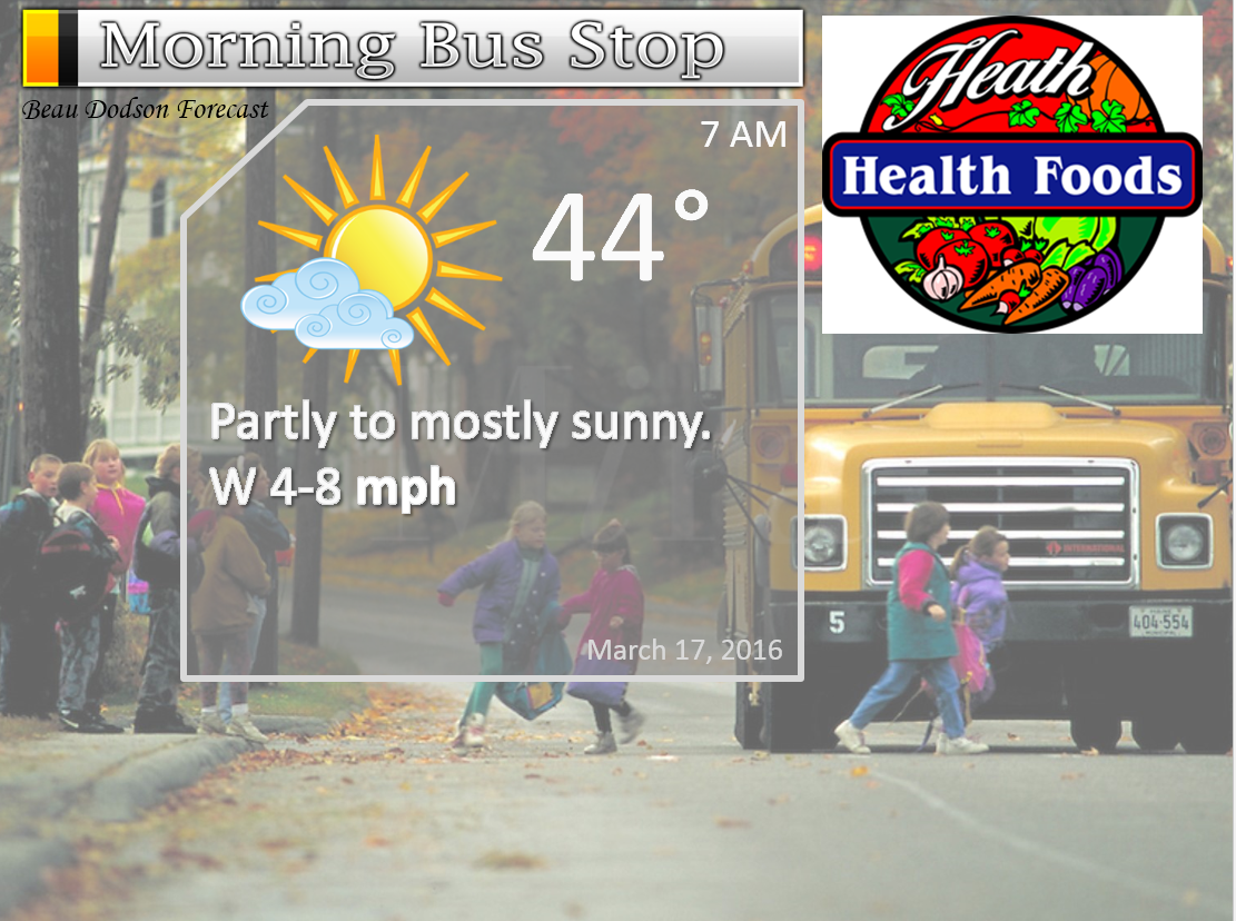
Wednesday Night – Quite a few clouds with a 10% chance for a shower. Cool.
Temperatures: Lows in the 38 to 44 degree range.
Winds: West and southwest winds at 5 mph.
What is the chance for precipitation? 10%
Coverage of precipitation? Isolated
My confidence in this part of the forecast verifying is High
Should I be concerned about snow or ice? No
Should I cancel my outdoor plans? No
Is severe weather expected? No
What impact is expected? None. If a shower develops then wet roadways.
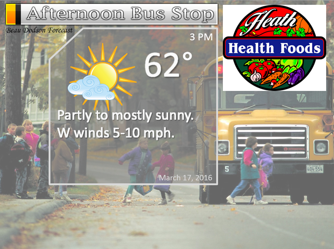
Thursday – Mix of sun and clouds. Still fairly mild, but cooler than recent days.
Temperatures: High temperatures will range from 58 to 64 degrees.
Winds: West winds at 4-8 mph. Gusts to 15 mph.
What is the chance for precipitation? 0%
Coverage of precipitation? None
My confidence in this part of the forecast verifying is High
Should I be concerned about snow or ice? No
Should I cancel my outdoor plans? No.
Is severe weather expected? No
What impact is expected? None
Thursday Night – Mostly clear. Cooler.
Temperatures: Lows in the 38 to 44 degree range.
Winds: West winds at 4-8 mph.
What is the chance for precipitation? 0%
Coverage of precipitation? None
My confidence in this part of the forecast verifying is High
Should I be concerned about snow or ice? No
Should I cancel my outdoor plans? No
Is severe weather expected? No
What impact is expected? None.
Friday – Mostly sunny in the morning. Increasing clouds in the afternoon. Cooler.
Temperatures: High temperatures will range from 55-60 degrees.
Winds: North and northwest winds at 4-8 mph.
What is the chance for precipitation? 10%
Coverage of precipitation? None
My confidence in this part of the forecast verifying is High
Should I be concerned about snow or ice? No
Should I cancel my outdoor plans? No.
Is severe weather expected? No
What impact is expected? None
Friday Night – Increasing clouds. A 40% chance for a shower. Small chance for a snowflake.
Temperatures: Lows in the 38 to 44 degree range.
Winds: West winds at 5 mph.
What is the chance for precipitation? 40%
Coverage of precipitation? Scattered
My confidence in this part of the forecast verifying is Medium
Should I be concerned about snow or ice? Unlikely
Should I cancel my outdoor plans? No
Is severe weather expected? No
What impact is expected? None. If a shower develops then wet roadways.
Saturday – Quite a few clouds. Cool. A 20% chance for a shower.
Temperatures: High temperatures will range from 48-54 degrees.
Winds: Northeast winds at 4-8 mph.
What is the chance for precipitation? 20%
Coverage of precipitation? None
My confidence in this part of the forecast verifying is Medium
Should I be concerned about snow or ice? No
Should I cancel my outdoor plans? No.
Is severe weather expected? No
What impact is expected? Maybe some wet roadways.
Saturday Night – Partly cloudy. Cold.
Temperatures: Lows in the 35-40 degree range.
Winds: West and northwest winds at 5 mph.
What is the chance for precipitation? 0%
Coverage of precipitation? None
My confidence in this part of the forecast verifying is Medium
Should I be concerned about snow or ice? No
Should I cancel my outdoor plans? No
Is severe weather expected? No
What impact is expected? None.
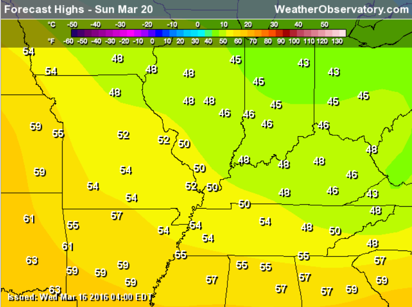
Sunday – Mostly sunny. Cool.
Temperatures: High temperatures will range from 48-52 degrees.
Winds: Northwest winds at 4-8 mph.
What is the chance for precipitation? 0%
Coverage of precipitation? None
My confidence in this part of the forecast verifying is Medium
Should I be concerned about snow or ice? No
Should I cancel my outdoor plans? No.
Is severe weather expected? No
What impact is expected? None
The School Bus Stop Forecast is sponsored by Heath Health and Wellness. Located next to Crowell Pools in Lone Oak.

Heath Health Foods is a locally owned and operated retail health and wellness store. Since opening in February 2006; the store has continued to grow as a ministry with an expanding inventory which also offers wellness appointments and services along with educational opportunities. Visit their web-site here. And. visit Heath Health Foods on Facebook!
These numbers are off by one hour starting Sunday. I have submitted a ticket to fix them.

Don’t forget to check out the Southern Illinois Weather Observatory web-site for weather maps, tower cams, scanner feeds, radars, and much more! Click here

An explanation of what is happening in the atmosphere over the coming days…
- Cooler weather
- Fairly calm weather for March
- No severe storms in the forecast
The weather has become calm. This is a bit unusual for late March. But, we sure do need to dry out. Way too much rain lately. Let’s enjoy the break.
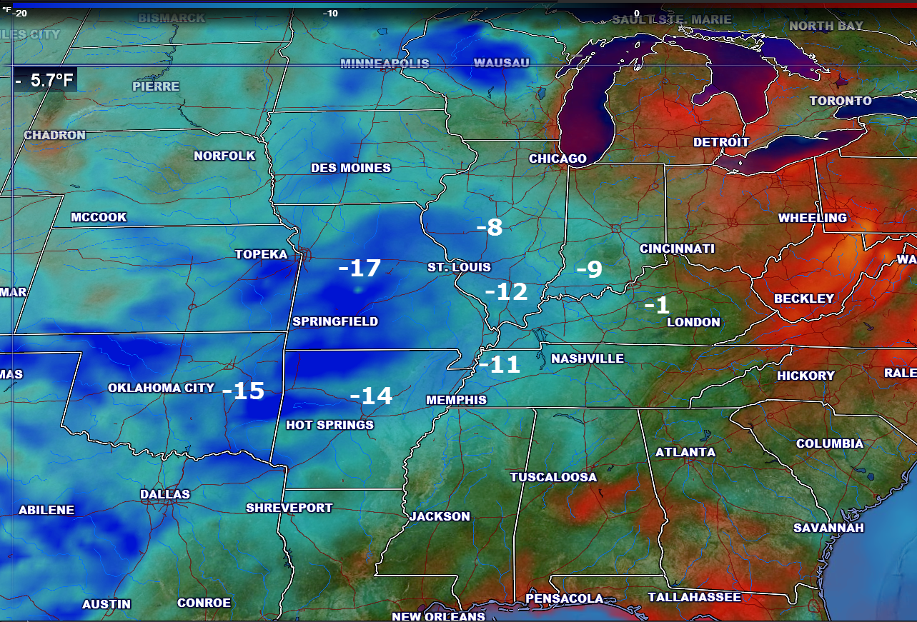
What a difference 24 hours make. Yesterday temperatures were in the upper 70s to middle 80s over our region. WAY above normal. Let’s look at the 24 hour temperature change map. This shows you how many degrees cooler it is today (at 12 pm) than yesterday.
We will have a couple of weather systems zip across the region over the coming five days. Moisture return with each system will be anemic. Thus, rain chances aren’t going to be all that great. We will also experience a cooling trend through the weekend.
One of the weak systems will pass through our region tonight and Thursday morning (early). Some clouds and maybe a light shower will accompany the system. Trace amounts of rain in some spots. Dry will be the general rule.
Another system approaches on Friday afternoon (late) into Saturday night. I can’t rule out a shower with this system. But, it really does not look like much.
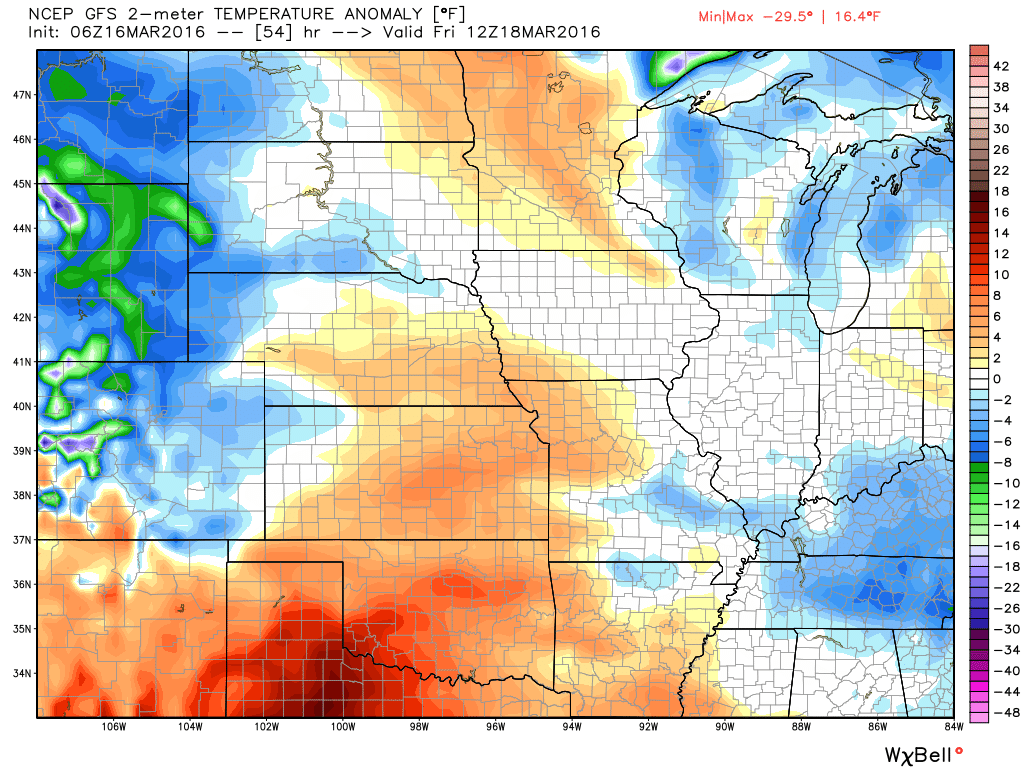
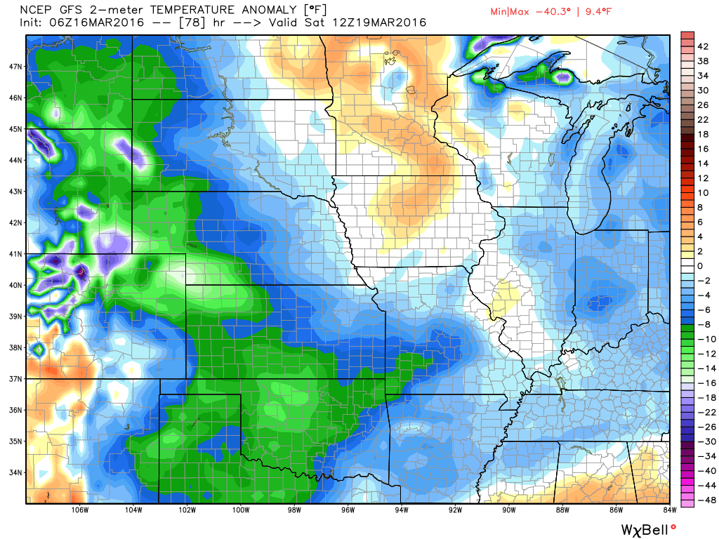
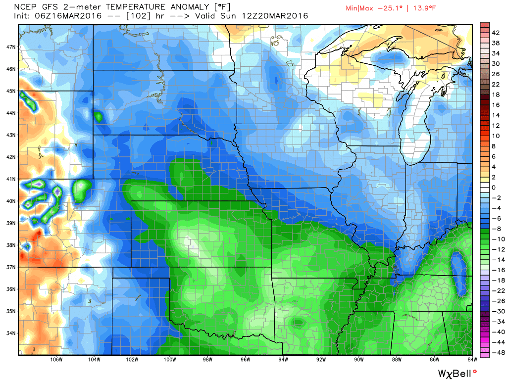
I suppose the bigger story will be colder weather. Temperatures by Friday, Saturday, and Sunday morning will dip to below normal. Expect some 30s for morning lows. And chilly highs in the upper 40s to middle 50s. Normal low temperatures are from 38-40 degrees. Some morning we will be near normal. Other mornings we will dip below normal.
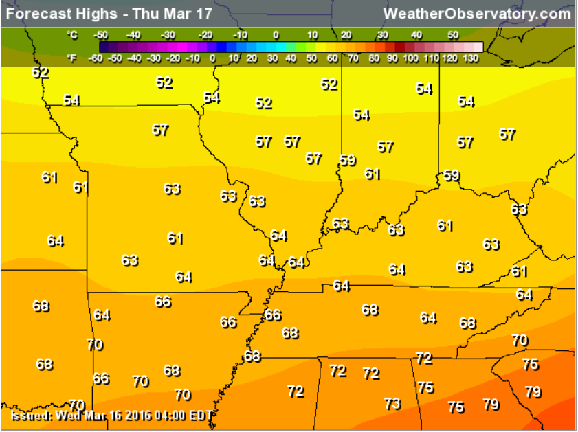
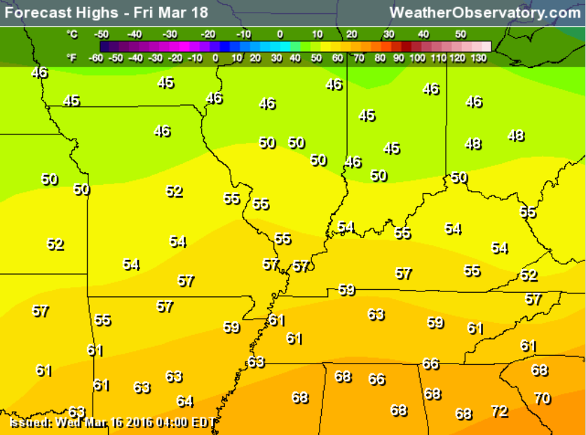
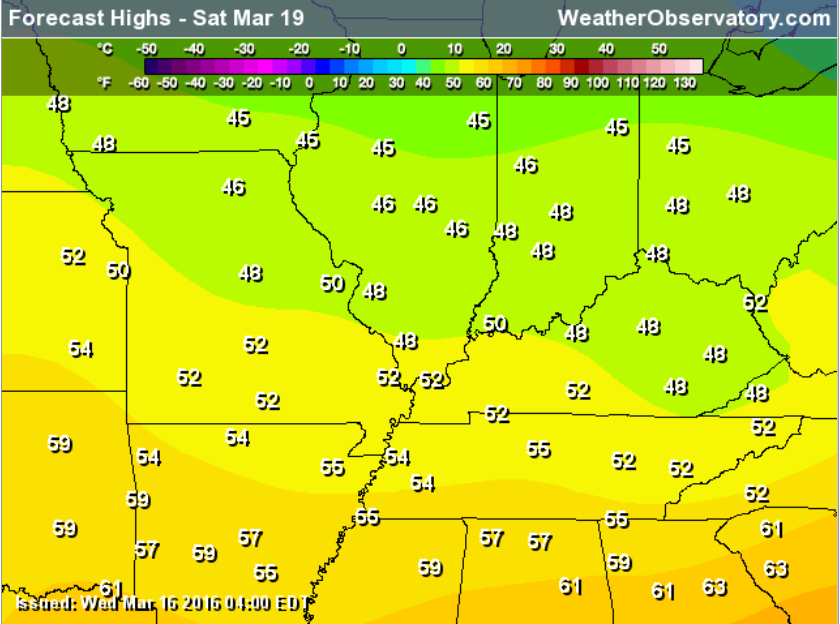
Let’s walk through the temperatures.
Thursday high temperatures
Friday
Saturday highs
Sunday highs
Let’s look at the temperature anomalies each morning (how many degrees above or below normal will temperatures be). This first map is for Friday morning. Normal low temperatures are around 38-40 degrees. We will dip below normal on some mornings. Images are from weatherbell.com
Saturday morning. This map shows you how many degrees above or below normal temperatures will be.
Sunday morning anomalies
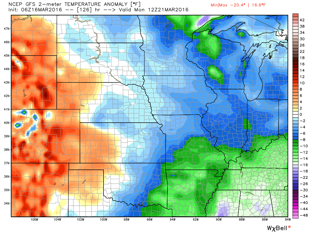
Monday morning anomalies

Here are the current river stage forecasts. You can click your state and then the dot for your location. It will bring up the full forecast and hydrograph.

Can we expect severe thunderstorms over the next 24 to 48 hours? Remember that a severe thunderstorm is defined as a thunderstorm that produces 58 mph winds or higher, quarter size hail or larger, and/or a tornado.
.
Thunderstorms are not expected through the weekend.
.

No major changes in this forecast package.
.

No concerns.

No

How much precipitation should we expect over the next few days?
Small chance for light rain on Wednesday night. Perhaps some more light showers this weekend. Not expecting anything significant. Light rain showers.

Here is the official 6-10 day and 8-14 day temperature and precipitation outlook. Check the date stamp at the top of each image (so you understand the time frame).
The forecast maps below are issued by the Weather Prediction Center (NOAA).


The latest 8-14 day temperature and precipitation outlook. Note the dates are at the top of the image. These maps DO NOT tell you how high or low temperatures or precipitation will be. They simply give you the probability as to whether temperatures or precipitation will be above or below normal.


Who do you trust for your weather information and who holds them accountable?
I have studied weather in our region since the late 1970’s. I have 37 years of experience in observing our regions weather patterns. My degree is in Broadcast Meteorology from Mississippi State University and an Associate of Science (AS). I am currently working on my Bachelor’s Degree in Geoscience.
My resume includes:
Member of the American Meteorological Society.
NOAA Weather-Ready Nation Ambassador.
Meteorologist for McCracken County Emergency Management. I served from 2005 through 2015.
I own and operate the Southern Illinois Weather Observatory.
Recipient of the Mark Trail Award, WPSD Six Who Make A Difference Award, Kentucky Colonel, and the Caesar J. Fiamma” Award from the American Red Cross.
In 2009 I was presented with the Kentucky Office of Highway Safety Award.
Recognized by the Kentucky House of Representatives for my service to the State of Kentucky leading up to several winter storms and severe weather outbreaks.
I am also President of the Shadow Angel Foundation which serves portions of western Kentucky and southern Illinois.
There is a lot of noise on the internet. A lot of weather maps are posted without explanation. Over time you should learn who to trust for your weather information.
My forecast philosophy is simple and straight forward.
- Communicate in simple terms
- To be as accurate as possible within a reasonable time frame before an event
- Interact with you on Twitter, Facebook, and the blog
- Minimize the “hype” that you might see on television or through other weather sources
- Push you towards utilizing wall-to-wall LOCAL TV coverage during severe weather events
I am a recipient of the Mark Trail Award, WPSD Six Who Make A Difference Award, Kentucky Colonel, and the Caesar J. Fiamma” Award from the American Red Cross. In 2009 I was presented with the Kentucky Office of Highway Safety Award. I was recognized by the Kentucky House of Representatives for my service to the State of Kentucky leading up to several winter storms and severe weather outbreaks.
If you click on the image below you can read the Kentucky House of Representatives Resolution.

Many of my graphics are from www.weatherbell.com – a great resource for weather data, model data, and more


You can sign up for my AWARE email by clicking here I typically send out AWARE emails before severe weather, winter storms, or other active weather situations. I do not email watches or warnings. The emails are a basic “heads up” concerning incoming weather conditions.