We have some great sponsors for the Weather Talk Blog. Please let our sponsors know that you appreciate their support for the Weather Talk Blog.
Milner and Orr Funeral Home and Cremation Services located in Paducah, Kentucky and three other western Kentucky towns – at Milner and Orr they believe in families helping families. You can find Milner and Orr on Facebook, as well.
![]()
.

For all of your families eye care needs. Visit their web-site here. Or, you can also visit their Facebook page.
.

Best at Enabling Body Shop Profitability since 1996. Located In Paducah Kentucky and Evansville Indiana; serving all customers in between. They provide Customer Service, along with all the tools necessary for body shops to remain educated and competitive. Click the logo above for their main web-site. You can find McClintock Preferred Finishes on Facebook, as well

Expressway Carwash and Express Lube are a locally owned and operated full service Carwash and Lube established in 1987. We have been proudly serving the community for 29 years now at our Park Avenue location and 20 years at our Southside location. We have been lucky enough to partner with Sidecar Deli in 2015, which allows us to provide our customers with not only quality service, but quality food as well. . If you haven’t already, be sure to make Expressway your one stop shop, with our carwash, lube and deli. For hours of operation and pricing visit www.expresswashlube.com or Expressway Carwash on Facebook.
I have launched the new weather texting service! I could use your help. Be sure and sign up and fully support all of the weather data you see each day.
This is a monthly subscription service. Supporting this helps support everything else. The cost is $3 a month for one phone, $5 a month for three phones, and $10 a month for seven phones.
For more information visit BeauDodsonWeather.com
Or directly sign up at Weathertalk.com


This forecast update covers far southern Illinois, far southeast Missouri, and far western Kentucky. See the coverage map on the right side of the blog.
Remember that weather evolves. Check back frequently for updates, especially during active weather.

Weather Radars
WEATHER RADAR PAGE – Click here
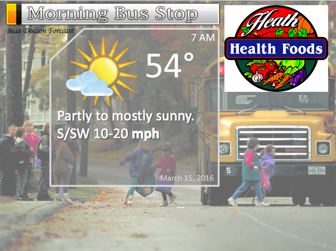
Monday Night – Partly cloudy.
Temperatures: Lows in the 54-58 degree range
Winds: South winds 6-12 mph. Gusty after 4 am.
What is the chance for precipitation? 0%
Coverage of precipitation? None
My confidence in this part of the forecast verifying is High
Should I be concerned about snow or ice? No
Should I cancel my outdoor plans? No
Is severe weather expected? No
What impact is expected? None.
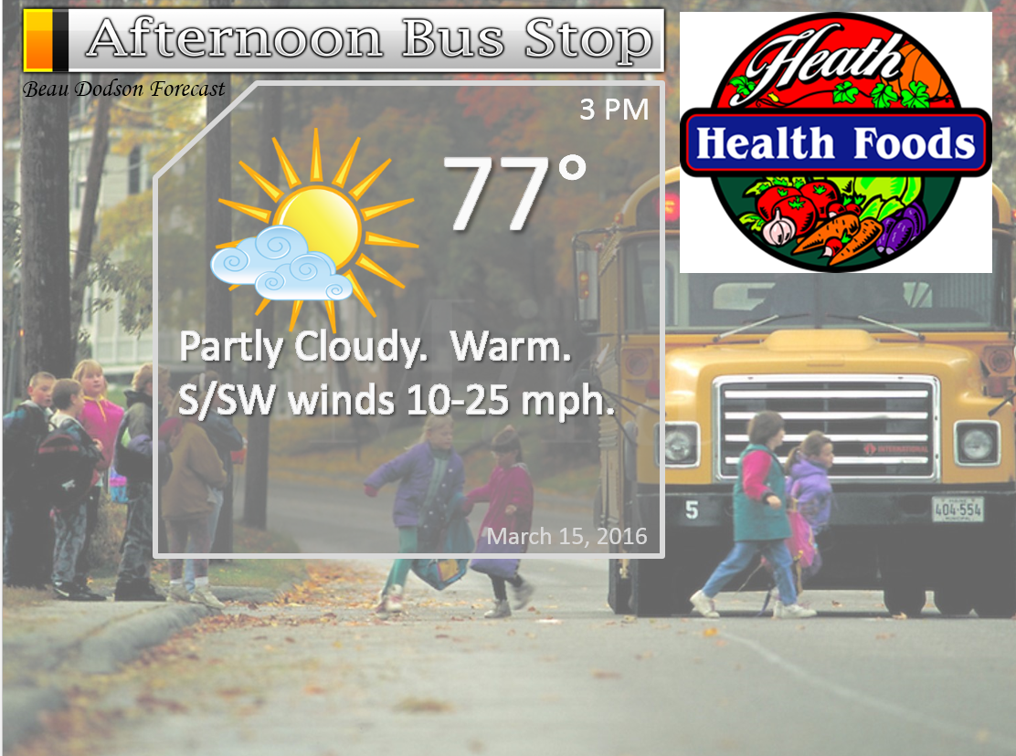
Tuesday – Partly cloudy and warm. Well above normal temperatures. A 10% chance for a morning rain shower. Then, a 20% chance for a thunderstorm developing. This would mainly be for southeast Illinois and northwest Kentucky.
Temperatures: High temperatures will range from 72-76 degrees. Isolated 80 degrees.
Winds: South/southwest winds 10-20 mph with gusts above 30 mph.
What is the chance for precipitation? 10%-20%
Coverage of precipitation? Isolated if any at all.
My confidence in this part of the forecast verifying is Medium
Should I be concerned about snow or ice? No
Should I cancel my outdoor plans? No.
Is severe weather expected? Isolated risk.
What impact is expected? Gusty winds. If storms form then gusty winds, lighting, and hail possible. This would mainly be for the Mt Vernon, IL area into northwest Kentucky. Lesser chances elsewhere.
Tuesday Night – Mostly clear. Small chance for an evening storm over our northeast and eastern counties. That would be northwest Kentucky towards Hopkinsville.
Temperatures: Lows in the 46-52 degree range
Winds: Southwest winds becoming west at 5-10 mph. Gusty early in the evening.
What is the chance for precipitation? 20% early in the evening.
Coverage of precipitation? Isolated early
My confidence in this part of the forecast verifying is High
Should I be concerned about snow or ice? No
Should I cancel my outdoor plans? No
Is severe weather expected? Small risk early in the evening. Mainly eastern counties.
What impact is expected? Early in the evening thunderstorms could produce gusty winds, hail, and lightning. Mainly eastern counties (if they develop)
Wednesday – Mostly sunny during the morning. Increasing clouds during the afternoon. Mild.
Temperatures: High temperatures will range from 64-68 degrees.
Winds: West winds at 5-10 mph.
What is the chance for precipitation? 10%
Coverage of precipitation? None
My confidence in this part of the forecast verifying is High
Should I be concerned about snow or ice? No
Should I cancel my outdoor plans? No.
Is severe weather expected? No
What impact is expected? None
Wednesday Night – Quite a few clouds with a 10% chance for a shower. Cool.
Temperatures: Lows in the 38 to 44 degree range.
Winds: West winds at 5 mph.
What is the chance for precipitation? 10%
Coverage of precipitation? Isolated
My confidence in this part of the forecast verifying is High
Should I be concerned about snow or ice? No
Should I cancel my outdoor plans? No
Is severe weather expected? No
What impact is expected? None. If a shower develops then wet roadways.
Thursday – Mostly sunny. Cooler.
Temperatures: High temperatures will range from 58 to 64 degrees.
Winds: West winds at 4-8 mph.
What is the chance for precipitation? 0%
Coverage of precipitation? None
My confidence in this part of the forecast verifying is High
Should I be concerned about snow or ice? No
Should I cancel my outdoor plans? No.
Is severe weather expected? No
What impact is expected? None
Thursday Night – Partly cloudy. Cooler.
Temperatures: Lows in the 38 to 44 degree range.
Winds: West winds at 5 mph.
What is the chance for precipitation? 20%
Coverage of precipitation? Isolated early in the day
My confidence in this part of the forecast verifying is High
Should I be concerned about snow or ice? No
Should I cancel my outdoor plans? No
Is severe weather expected? No
What impact is expected? None. If a shower develops then wet roadways.
Friday – Mostly sunny. Cooler.
Temperatures: High temperatures will range from 55-60 degrees.
Winds: North and northwest winds at 4-8 mph.
What is the chance for precipitation? 0%
Coverage of precipitation? None
My confidence in this part of the forecast verifying is High
Should I be concerned about snow or ice? No
Should I cancel my outdoor plans? No.
Is severe weather expected? No
What impact is expected? None
Friday Night – Partly cloudy. A 30% chance for a shower.
Temperatures: Lows in the 38 to 44 degree range.
Winds: West winds at 5 mph.
What is the chance for precipitation? 30%
Coverage of precipitation? Isolated
My confidence in this part of the forecast verifying is Medium
Should I be concerned about snow or ice? No
Should I cancel my outdoor plans? No
Is severe weather expected? No
What impact is expected? None. If a shower develops then wet roadways.
Saturday – Quite a few clouds. Cool. A 30% chance for a shower.
Temperatures: High temperatures will range from 48-54 degrees.
Winds: Northeast winds at 4-8 mph.
What is the chance for precipitation? 30%
Coverage of precipitation? None
My confidence in this part of the forecast verifying is Medium
Should I be concerned about snow or ice? No
Should I cancel my outdoor plans? No.
Is severe weather expected? No
What impact is expected? Maybe some wet roadways.
Saturday Night – Quite a few clouds. A 20% chance for a shower.
Temperatures: Lows in the 35-40 degree range.
Winds: West winds at 5 mph.
What is the chance for precipitation? 20%
Coverage of precipitation? Isolated
My confidence in this part of the forecast verifying is Medium
Should I be concerned about snow or ice? No
Should I cancel my outdoor plans? No
Is severe weather expected? No
What impact is expected? None. If a shower develops then wet roadways.
Sunday – Quite a few clouds. Cool temperatures.
Temperatures: High temperatures will range from 50-55 degrees.
Winds: Northwest winds at 4-8 mph.
What is the chance for precipitation? 10%
Coverage of precipitation? None
My confidence in this part of the forecast verifying is Medium
Should I be concerned about snow or ice? No
Should I cancel my outdoor plans? No.
Is severe weather expected? No
What impact is expected? None
The School Bus Stop Forecast is sponsored by Heath Health and Wellness. Located next to Crowell Pools in Lone Oak.

Heath Health Foods is a locally owned and operated retail health and wellness store. Since opening in February 2006; the store has continued to grow as a ministry with an expanding inventory which also offers wellness appointments and services along with educational opportunities. Visit their web-site here. And. visit Heath Health Foods on Facebook!
These numbers are off by one hour starting Sunday. I have submitted a ticket to fix them.

Don’t forget to check out the Southern Illinois Weather Observatory web-site for weather maps, tower cams, scanner feeds, radars, and much more! Click here

An explanation of what is happening in the atmosphere over the coming days…
- Warm on Tuesday
- Windy on Tuesday
- Small chance for a strong storms Tuesday afternoon and night
- Cooler Wednesday into the weekend.
Portions of the region are coming out of an extremely wet seven day period. Widespread 1.5-4″ of rain fell over about 60%-70% of the area. The least amount of rain was over southeast Missouri and southwest Illinois. Totals there ranged from 0.25″-1.00″. Parts of southern Illinois, western Kentucky, the Missouri Bootheel, and northwest Tennessee picked up 1″ to 10″ of rain. I am sure you have seen some of the flood photos from western Tennessee.
The event also produced one report of wind damage. That was in southwest Calloway County on Saturday night. Otherwise, no other severe weather was reported, thankfully. Arkansas was hit hard last night with tornadoes and hail. The storms weakened as they moved into our region, as expected.
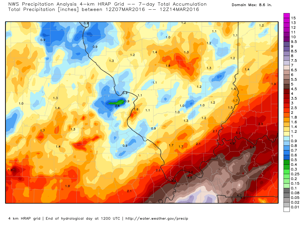
Let’s take a look at those rainfall totals. This was a big rain event for many areas. These are the seven day rainfall totals.
Here is the Missouri and Illinois view. Notice the least amount was over the northern parts of southeast Missouri.
Here is the Kentucky and Tennessee version. Note that very heavy band that moved through western Tennessee into the Pennyrile area of western Kentucky. Ten days ago it appeared that would be the area with the least amount of rain. All the forecasts had to shift last Wednesday. The system lived up to its potential.
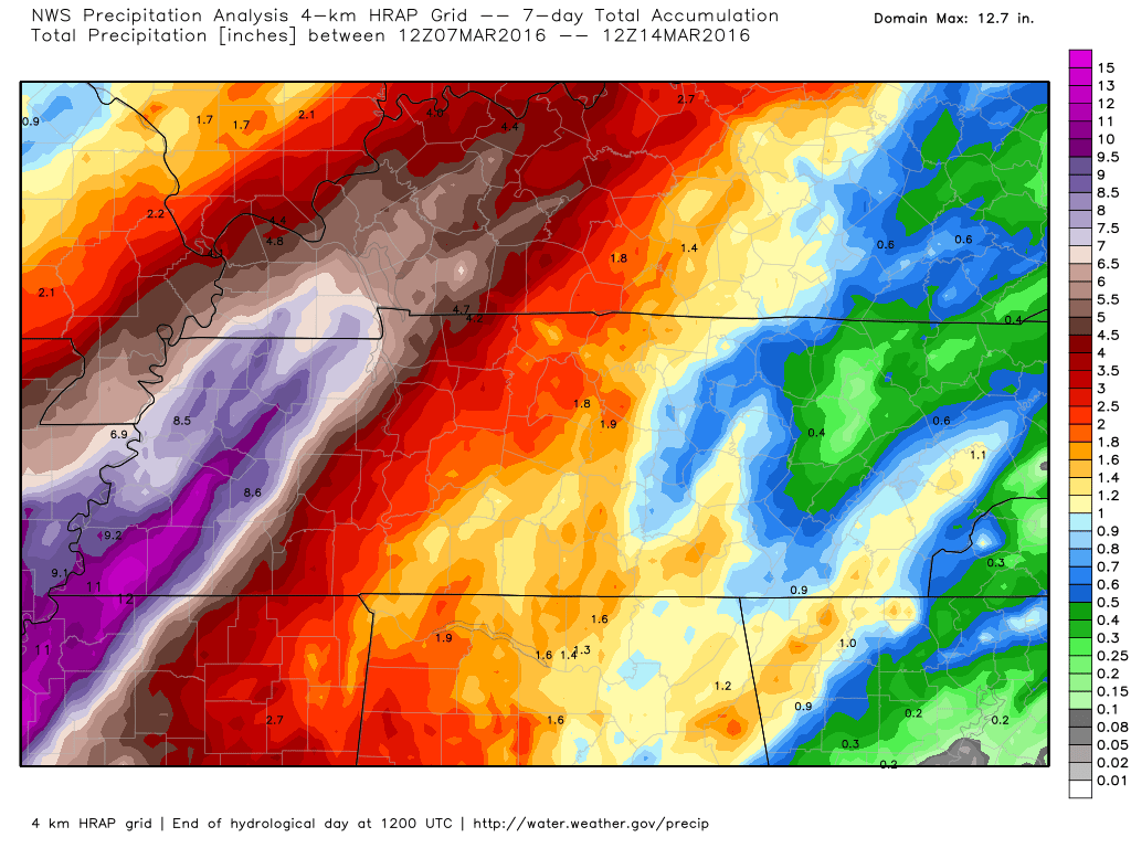
This was a well forecast event from 12 days out. The only shift was last Wednesday when I had to adjust the heaviest rain axis quite a bit eastward.
Hopefully we can find ourselves a break from the big rain totals (at least for awhile). I am not tracking any major rain producers in the short term. Which, is great news.
I am, however, tracking at least some precipitation makers over the coming seven days. Mostly on the light side. Cooler temperatures, as well.
Several fast moving systems will either brush or move through our region starting on Tuesday afternoon.
There is a small chance for a shower on Tuesday morning.
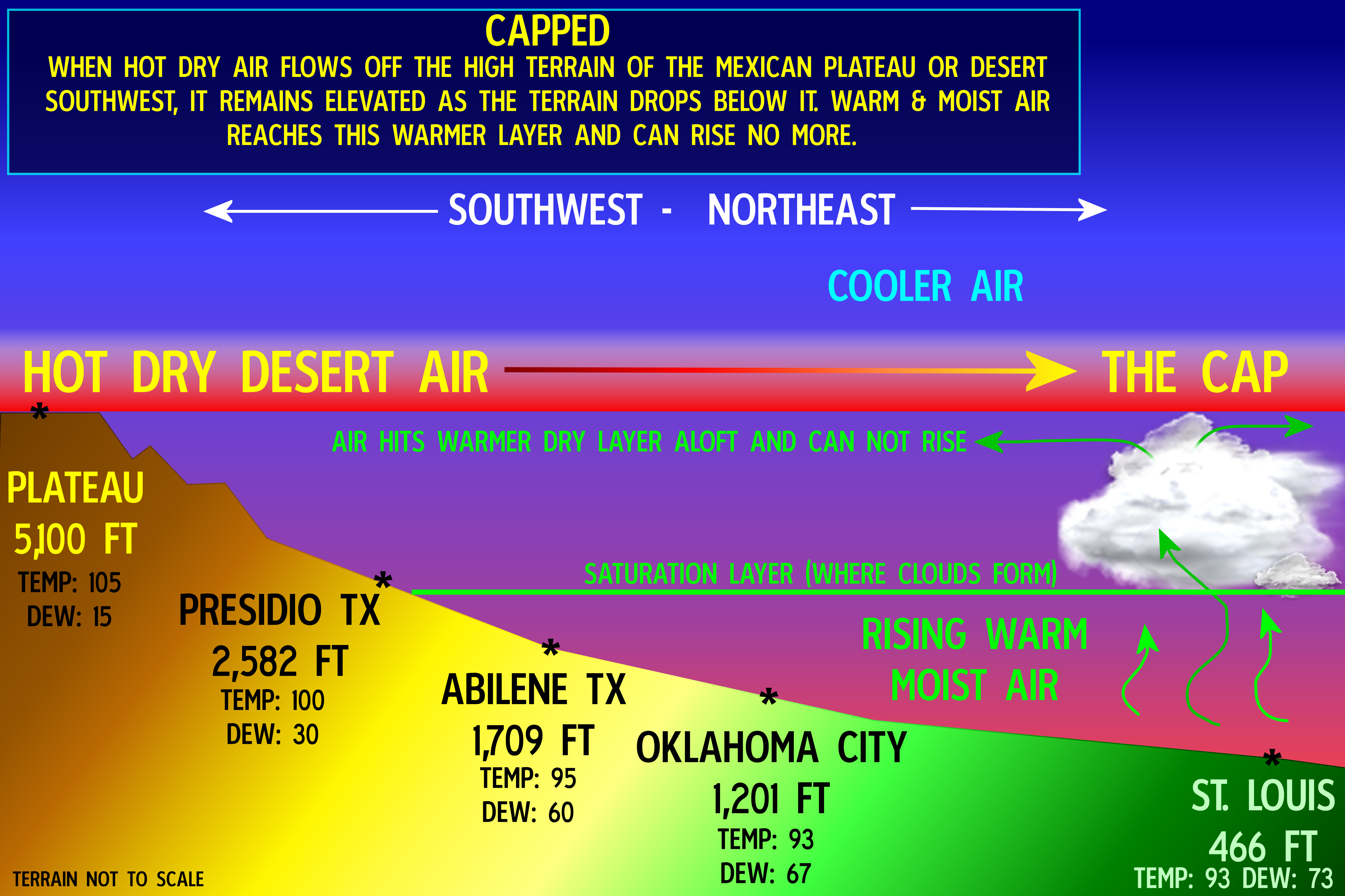
The main system arrives on Tuesday afternoon and night. Thankfully we will be mostly CAPPED. A CAP is a warm layer aloft. This warm layer aloft can keep thunderstorms from forming. In order to break the CAP you need lift. Strong lift. We will have a cold front tomorrow. That will act as a lift. But, the CAP may be strong enough to prevent even the cold front from lifting the air.
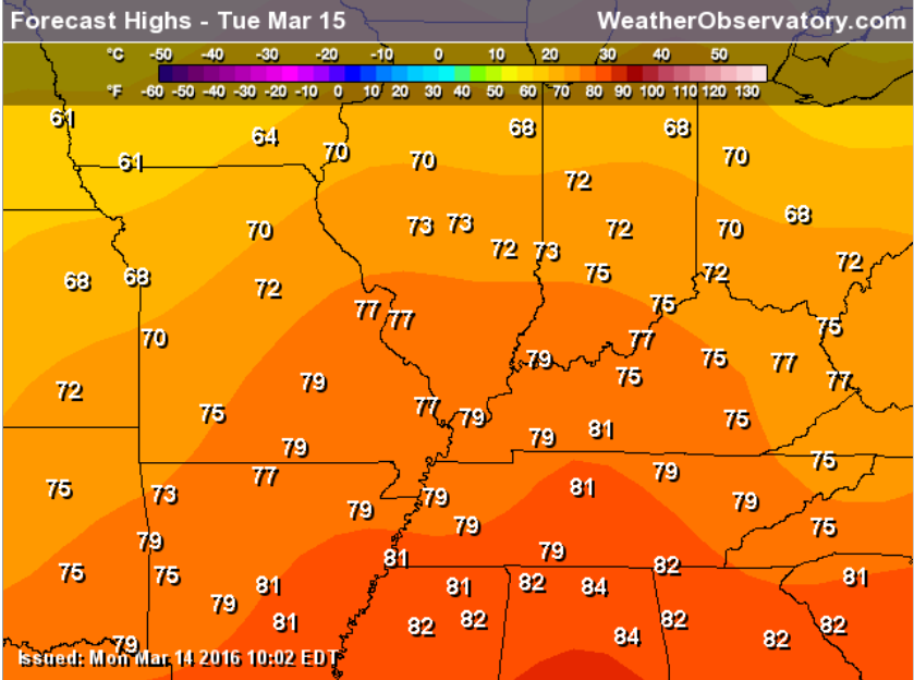
Warm temperatures on Tuesday. Perhaps some of the warmest air of the season. Here is the high temperature map for Tuesday afternoon.
Officially the Storm Prediction Center has outlined our region for severe storms. But, I believe the CAP will keep the chances very low for thunderstorm develop. If storms were to form then they would be from Mt Vernon, Illinois towards northwest Kentucky. Perhaps a 20% chance. And, less than 20% chance elsewhere.
If storms do form then they would be intense.
Here is an example of the CAP. Although temperatures won’t be this warm on Tuesday. This graphic just gives you an idea of what I am talking about. Warm layer aloft = the CAP. The CAP prevents rising warm/moist air from moving beyond the warm layer. Thus, capping the chance for storms. If the rising air does break through the warm layer then explosive thunderstorm activity can occur. You will hear me talk about the CAP quite often during the spring and summer months.
Cooler temperatures are expected Wednesday into the weekend. However, nothing extreme. Just cooler (more seasonal).
High temperatures in the middle 60s are possible Wednesday and Thursday. Highs on Friday will only be around 54-58 degrees. Highs on Saturday and Sunday will likely only be in the upper 40s to middle 50s. Cool. Low temperatures in the upper 30s are expected Thursday night, Friday night, and Saturday night.
A weak weather system will skirt our area on Wednesday afternoon and Wednesday night. Perhaps a few showers. Another system around Friday night and Saturday. A few showers possible at that time, as well.

Here are the current river stage forecasts. You can click your state and then the dot for your location. It will bring up the full forecast and hydrograph.

Can we expect severe thunderstorms over the next 24 to 48 hours? Remember that a severe thunderstorm is defined as a thunderstorm that produces 58 mph winds or higher, quarter size hail or larger, and/or a tornado.
.
Tuesday:
A small chance for a strong thunderstorm on Tuesday afternoon and Tuesday night. This would mostly be from Mt Vernon, Illinois towards northwest Kentucky. If storms do form then they could produce high winds and hail. The overall risk is small. There is a warm layer aloft (this is called a CAP) that should help prevent much in the way of activity for our region. I will keep an eye on it. Officially the Storm Prediction Center does have us in a risk zone.
.

No major changes in this forecast package.
.

There is a small risk for a strong thunderstorm over southeast Illinois and northwest Kentucky on Tuesday afternoon and night. If a storm does form then it could be intense. Otherwise, no major problems anticipated.

No problems anticipated. I will keep an eye on storm chances for Tuesday afternoon and night. This event should be more to our north and east.

How much precipitation should we expect over the next few days?
A small chance for thunderstorms on Tuesday afternoon and night. This event should mostly be to our north and east. But, if a storm does pop up it could drop heavy rain. Rainfall totals will be 0.00″ for most of the region. If a storm does form then 0.25″-0.50″ could fall. The chance of this is around 20%.

Here is the official 6-10 day and 8-14 day temperature and precipitation outlook. Check the date stamp at the top of each image (so you understand the time frame).
The forecast maps below are issued by the Weather Prediction Center (NOAA).


The latest 8-14 day temperature and precipitation outlook. Note the dates are at the top of the image. These maps DO NOT tell you how high or low temperatures or precipitation will be. They simply give you the probability as to whether temperatures or precipitation will be above or below normal.


Who do you trust for your weather information and who holds them accountable?
I have studied weather in our region since the late 1970’s. I have 37 years of experience in observing our regions weather patterns. My degree is in Broadcast Meteorology from Mississippi State University and an Associate of Science (AS). I am currently working on my Bachelor’s Degree in Geoscience.
My resume includes:
Member of the American Meteorological Society.
NOAA Weather-Ready Nation Ambassador.
Meteorologist for McCracken County Emergency Management. I served from 2005 through 2015.
I own and operate the Southern Illinois Weather Observatory.
Recipient of the Mark Trail Award, WPSD Six Who Make A Difference Award, Kentucky Colonel, and the Caesar J. Fiamma” Award from the American Red Cross.
In 2009 I was presented with the Kentucky Office of Highway Safety Award.
Recognized by the Kentucky House of Representatives for my service to the State of Kentucky leading up to several winter storms and severe weather outbreaks.
I am also President of the Shadow Angel Foundation which serves portions of western Kentucky and southern Illinois.
There is a lot of noise on the internet. A lot of weather maps are posted without explanation. Over time you should learn who to trust for your weather information.
My forecast philosophy is simple and straight forward.
- Communicate in simple terms
- To be as accurate as possible within a reasonable time frame before an event
- Interact with you on Twitter, Facebook, and the blog
- Minimize the “hype” that you might see on television or through other weather sources
- Push you towards utilizing wall-to-wall LOCAL TV coverage during severe weather events
I am a recipient of the Mark Trail Award, WPSD Six Who Make A Difference Award, Kentucky Colonel, and the Caesar J. Fiamma” Award from the American Red Cross. In 2009 I was presented with the Kentucky Office of Highway Safety Award. I was recognized by the Kentucky House of Representatives for my service to the State of Kentucky leading up to several winter storms and severe weather outbreaks.
If you click on the image below you can read the Kentucky House of Representatives Resolution.

Many of my graphics are from www.weatherbell.com – a great resource for weather data, model data, and more


You can sign up for my AWARE email by clicking here I typically send out AWARE emails before severe weather, winter storms, or other active weather situations. I do not email watches or warnings. The emails are a basic “heads up” concerning incoming weather conditions.