We have some great sponsors for the Weather Talk Blog. Please let our sponsors know that you appreciate their support for the Weather Talk Blog.
Milner and Orr Funeral Home and Cremation Services located in Paducah, Kentucky and three other western Kentucky towns – at Milner and Orr they believe in families helping families. You can find Milner and Orr on Facebook, as well.
![]()
.

For all of your families eye care needs. Visit their web-site here. Or, you can also visit their Facebook page.
.

Best at Enabling Body Shop Profitability since 1996. Located In Paducah Kentucky and Evansville Indiana; serving all customers in between. They provide Customer Service, along with all the tools necessary for body shops to remain educated and competitive. Click the logo above for their main web-site. You can find McClintock Preferred Finishes on Facebook, as well

Expressway Carwash and Express Lube are a locally owned and operated full service Carwash and Lube established in 1987. We have been proudly serving the community for 29 years now at our Park Avenue location and 20 years at our Southside location. We have been lucky enough to partner with Sidecar Deli in 2015, which allows us to provide our customers with not only quality service, but quality food as well. . If you haven’t already, be sure to make Expressway your one stop shop, with our carwash, lube and deli. For hours of operation and pricing visit www.expresswashlube.com or Expressway Carwash on Facebook.
I have launched the new weather texting service! I could use your help. Be sure and sign up and fully support all of the weather data you see each day.
This is a monthly subscription service. Supporting this helps support everything else. The cost is $3 a month for one phone, $5 a month for three phones, and $10 a month for seven phones.
For more information visit BeauDodsonWeather.com
Or directly sign up at Weathertalk.com


This forecast update covers far southern Illinois, far southeast Missouri, and far western Kentucky. See the coverage map on the right side of the blog.
Remember that weather evolves. Check back frequently for updates, especially during active weather.

Weather Radars
WEATHER RADAR PAGE – Click here
Sunday Night – Cloudy. A 60% chance for showers and thunderstorms. A strong storm possible with gusty winds and hail. Lightning, as well.
Temperatures: Lows in the 52-56 degree range
Winds: South winds 6-12 mph.
What is the chance for precipitation? 60%
Coverage of precipitation? Scattered to widespread
My confidence in this part of the forecast verifying is High
Should I be concerned about snow or ice? No
Should I cancel my outdoor plans? No
Is severe weather expected? Isolated risk. Strong winds and hail are possible with the most intense storms.
What impact is expected? Wet roadways. Lightning. A few reports of hail. Strong winds near the most intense storms.
Monday – Partly to mostly cloudy. A 20% chance for a morning shower.
Temperatures: High temperatures will range from 66-72
Winds: Southwest winds 6-12 mph. Gusts to 16 mph. Winds becoming more westerly during the afternoon.
What is the chance for precipitation? 20%
Coverage of precipitation? Isolated
My confidence in this part of the forecast verifying is High
Should I be concerned about snow or ice? No
Should I cancel my outdoor plans? No
Is severe weather expected? No
What impact is expected? Wet roadways.
Monday Night – Partly cloudy.
Temperatures: Lows in the 54-58 degree range
Winds: South winds 6-12 mph. Gusty after 4 am.
What is the chance for precipitation? 10%
Coverage of precipitation? None
My confidence in this part of the forecast verifying is High
Should I be concerned about snow or ice? No
Should I cancel my outdoor plans? No
Is severe weather expected? No
What impact is expected? None.
Tuesday – Partly cloudy and warm. Well above normal temperatures. A 30% chance for a thunderstorm developing. If storms do develop then they could be strong. Some question as to whether storms will form. There will be a warm layer of air aloft. This warm layer might prevent storms from forming. Cold front moves through the area during the afternoon hours.
Temperatures: High temperatures will range from 72-76 degrees. Isolated 80 degrees.
Winds: South/southwest winds 10-20 mph with gusts above 30 mph.
What is the chance for precipitation? 30%
Coverage of precipitation? Isolated if any at all.
My confidence in this part of the forecast verifying is Medium
Should I be concerned about snow or ice? No
Should I cancel my outdoor plans? No.
Is severe weather expected? Isolated risk.
What impact is expected? Gusty winds. If storms form then gusty winds, lighting, and hail possible.
Tuesday Night – Partly cloudy. turning cooler. Any evening thunderstorm activity will come to an end.
Temperatures: Lows in the 44-48 degree range
Winds: Southwest winds becoming northwest at 10-20 mph. Winds could be quite gusty during the evening hours. Winds lessening after midnight.
What is the chance for precipitation? 20% early in the evening.
Coverage of precipitation? Isolated early
My confidence in this part of the forecast verifying is High
Should I be concerned about snow or ice? No
Should I cancel my outdoor plans? No
Is severe weather expected? Small risk early in the evening. Mainly eastern counties.
What impact is expected? Early in the evening thunderstorms could produce gusty winds, hail, and lightning. Mainly eastern counties (if they develop)
Wednesday – Mostly sunny. Mild.
Temperatures: High temperatures will range from 62-66 degrees.
Winds: West winds at 5 mph.
What is the chance for precipitation? 0%
Coverage of precipitation? None
My confidence in this part of the forecast verifying is High
Should I be concerned about snow or ice? No
Should I cancel my outdoor plans? No.
Is severe weather expected? No
What impact is expected? None
Wednesday Night – Increasing clouds with a 20% chance for a shower. Cool.
Temperatures: Lows in the 38 to 44 degree range.
Winds: West winds at 5 mph.
What is the chance for precipitation? 20%
Coverage of precipitation? Isolated
My confidence in this part of the forecast verifying is High
Should I be concerned about snow or ice? No
Should I cancel my outdoor plans? No
Is severe weather expected? No
What impact is expected? None. If a shower develops then wet roadways.
Thursday – Mostly sunny. Cooler.
Temperatures: High temperatures will range from 58 to 64 degrees.
Winds: West winds at 5 mph.
What is the chance for precipitation? 0%
Coverage of precipitation? None
My confidence in this part of the forecast verifying is High
Should I be concerned about snow or ice? No
Should I cancel my outdoor plans? No.
Is severe weather expected? No
What impact is expected? None
Friday through Sunday should be partly to mostly cloudy. A 60% chance for showers Friday afternoon into Saturday morning. Then, a 20% chance for showers Saturday afternoon. Dry Saturday night into Sunday night. Highs in the upper 50s to lower 60s and lows in the upper 30s to lower 40s.
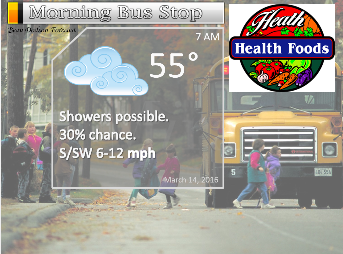
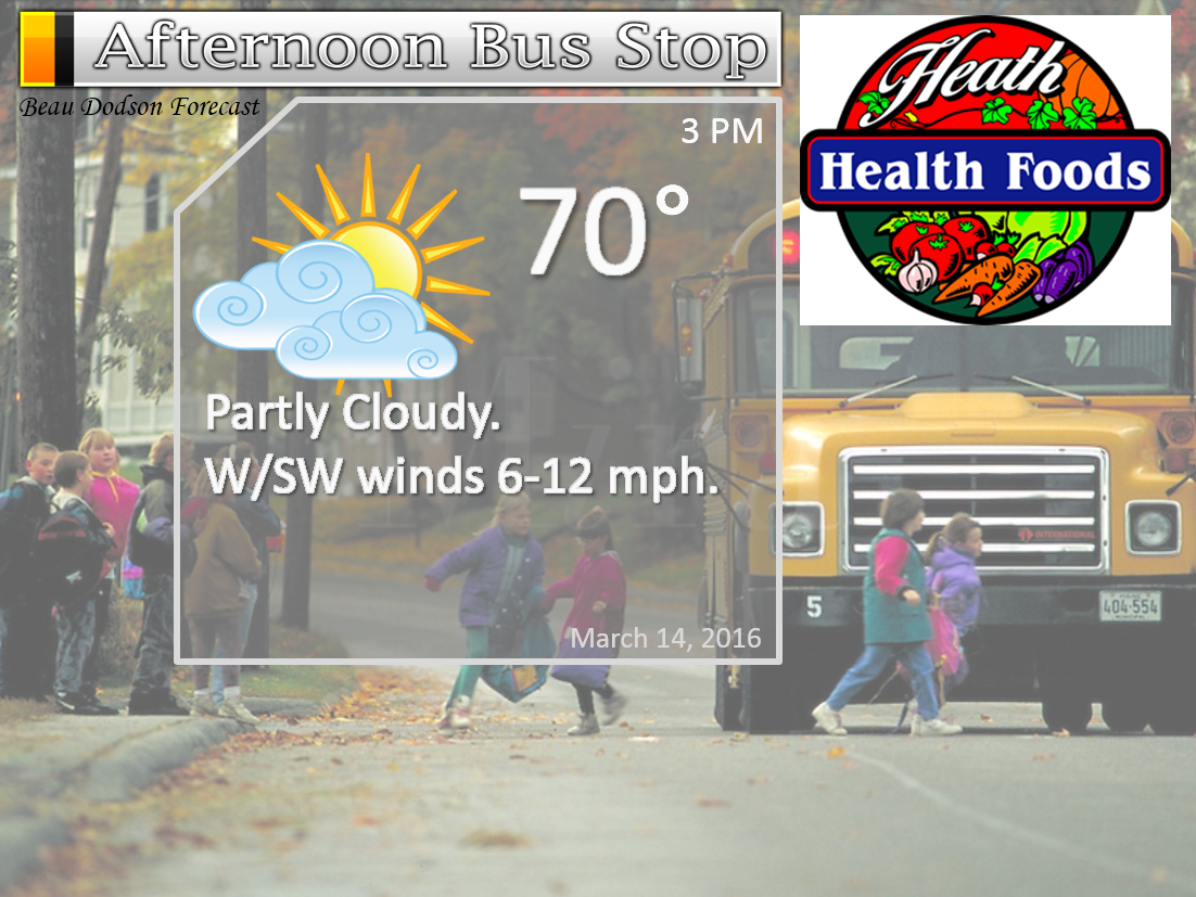
The School Bus Stop Forecast is sponsored by Heath Health and Wellness. Located next to Crowell Pools in Lone Oak.

Heath Health Foods is a locally owned and operated retail health and wellness store. Since opening in February 2006; the store has continued to grow as a ministry with an expanding inventory which also offers wellness appointments and services along with educational opportunities. Visit their web-site here. And. visit Heath Health Foods on Facebook!
These numbers are off by one hour starting Sunday. I have submitted a ticket to fix them.

Don’t forget to check out the Southern Illinois Weather Observatory web-site for weather maps, tower cams, scanner feeds, radars, and much more! Click here

An explanation of what is happening in the atmosphere over the coming days…
- Thunderstorms on Sunday night
- Mild both Monday and Tuesday
- Windy Tuesday
- A few storms on Tuesday?
- Cooler/colder Wednesday night into the weekend
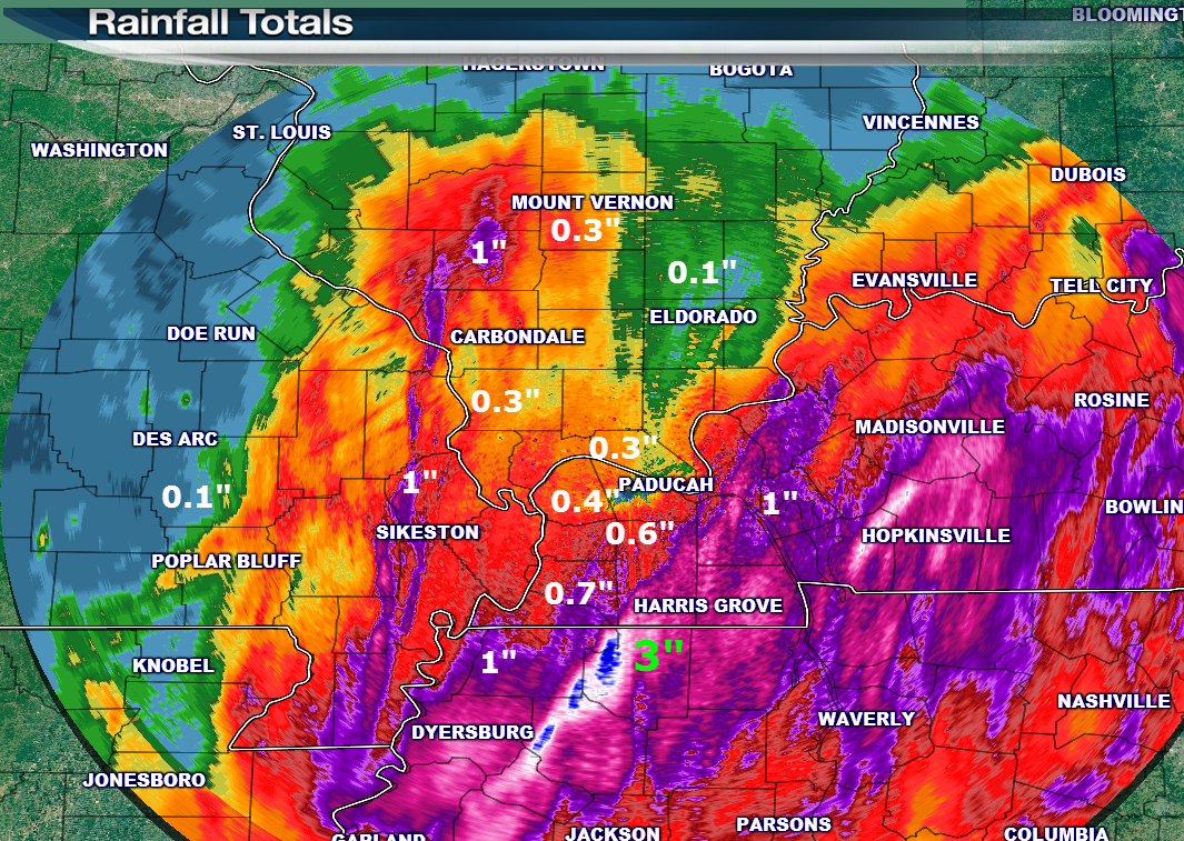
Showers and thunderstorms moved through the region on Saturday night and Sunday morning. As expected, rainfall totals varied greatly. Anywhere from less than 0.10″ to over 3″ fell in my forecast county area. Heaviest rains fell over northwest Tennessee and western Kentucky. Significant flooding occurred over northwest Tennessee. This included one levee break that caused the evacuation of twenty homes.
Martin, Tennessee experienced serious flooding. Some reports of two feet of water in the business district.
Here is a look at the radar estimated rainfall totals. I labeled a few of the colors. You can get some sense of the placement of the heavier rain bands via this image. Note the very heavy totals over northwest Tennessee. Same areas that were hit hard a few days ago. Some locations have picked up 7-10″ of rain over the past seven days.
————————————————————
SUNDAY NIGHT and MONDAY MORNING:
The main weather story for the next 12 hours will be a fast moving area of low pressure that will pass over our region later this afternoon and tonight (Sunday night). This system will spark severe thunderstorms over parts of Arkansas. Showers and thunderstorms will also develop over our local area. A few of the storms could be quite strong. I can’t rule out some reports of gusty winds, hail, frequent lightning, and heavy downpours.
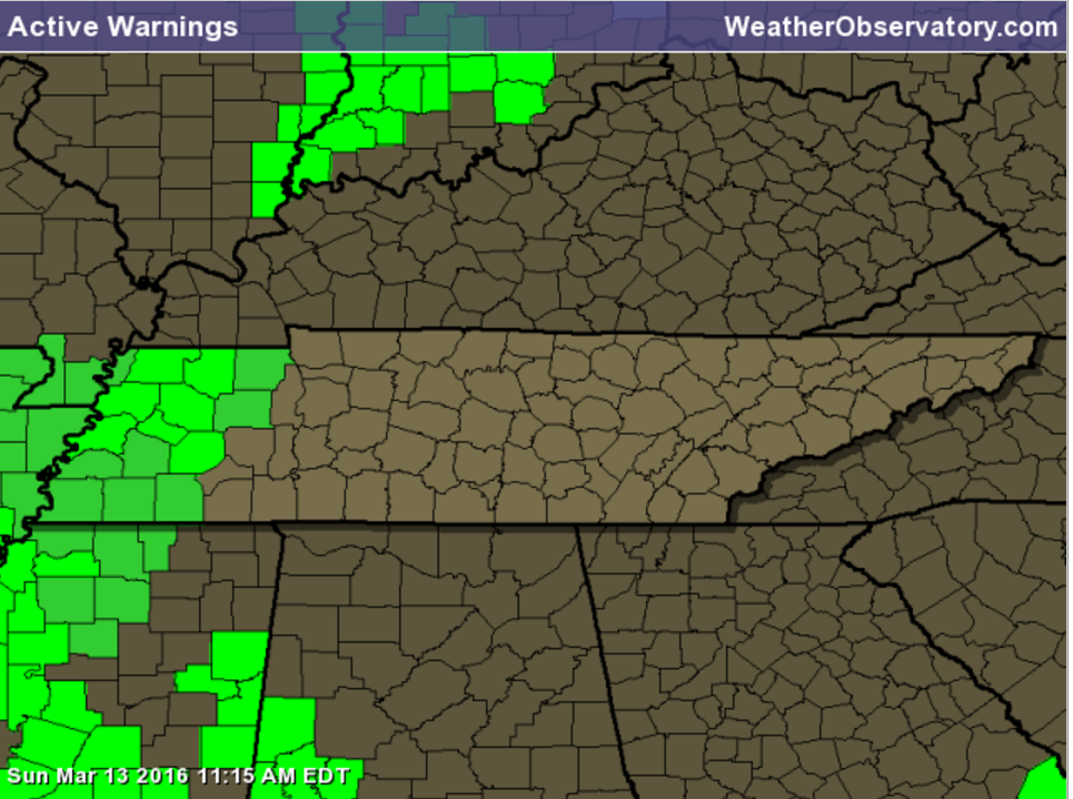
A flash flood watch remains in effect for the Missouri Bootheel and northwest Tennessee. This watch will expire at 7 am on Monday morning.
Here is the placement of that watch (in green)
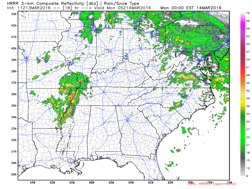
Let’s take a look at the HRRR model guidance. This data set shows storms in our region after 8 pm tonight and lasting into the early morning hours. There remains some question on the exact timing of the storms. But, I wanted to show you this future-cast radar.
This first image is what radar might look like at 12 am on Monday morning (late Sunday night). You can see a complex of showers and thunderstorms moving over parts of the region. Northern counties might not experience much in the way of precipitation. Southern counties should receive the higher totals.
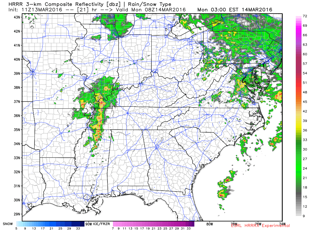
And, this next image is for 3 AM on Monday morning. Again, some question on the exact timing. Storms might arrive earlier than this model is showing.
Let’s look at another model. This one is the NAM/WRF. High resolution guidance. It shows storms earlier in the night. This is the 10 pm image.
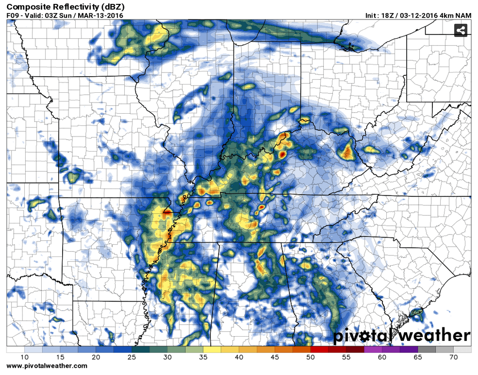
So, as you can see, there is some debate on the exact timing of showers and storms on Sunday night.
The system will pass off to our east on Monday morning. Only a few remaining showers are anticipated before the lunch hour on Monday. Most areas will remain dry on Monday.
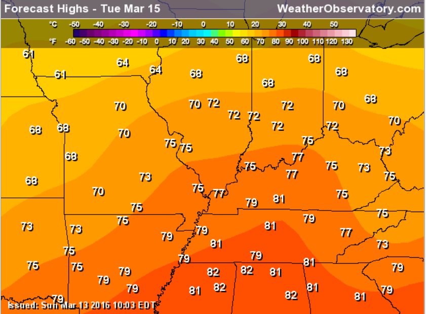
A strong cold front will sweep through our region on Tuesday. Warm and windy conditions will occur ahead of the cold front. High temperatures will be in the middle to upper 70s. Quite a bit of sunshine, as well. This will help make the atmosphere unstable. However, a warm layer of air aloft (called a CAP) might prevent thunderstorms from forming. The CAP will be weaker to our north. If the CAP were to break then a few severe thunderstorms could develop. This will need to be monitored.
At this time, the severe weather risk appears small on Tuesday, but not zero. I will examine the charts on Monday and update accordingly.
Check out the warm temperatures on Tuesday. Spring!
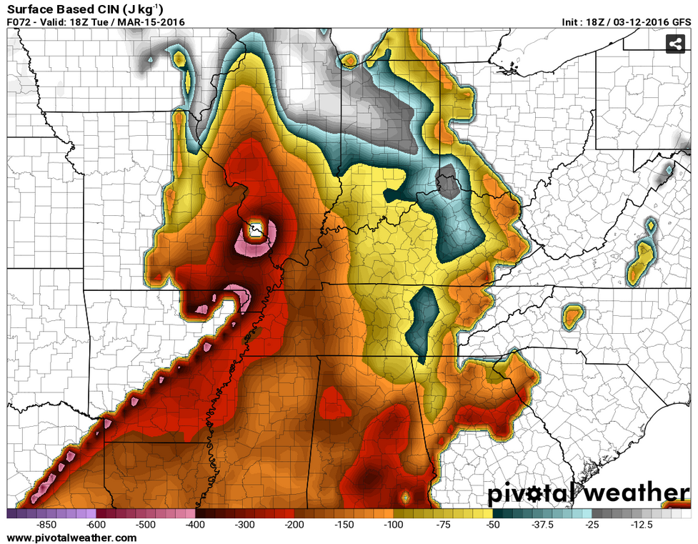
Here is a look at that CAP. A CAP is a warm layer of air aloft. These are some BIG numbers. Might be hard to break this CAP.
This first image is for the 11 am to 1 pm time frame. STRONG CAP. Those bright colors represent a strong lid on the atmosphere.
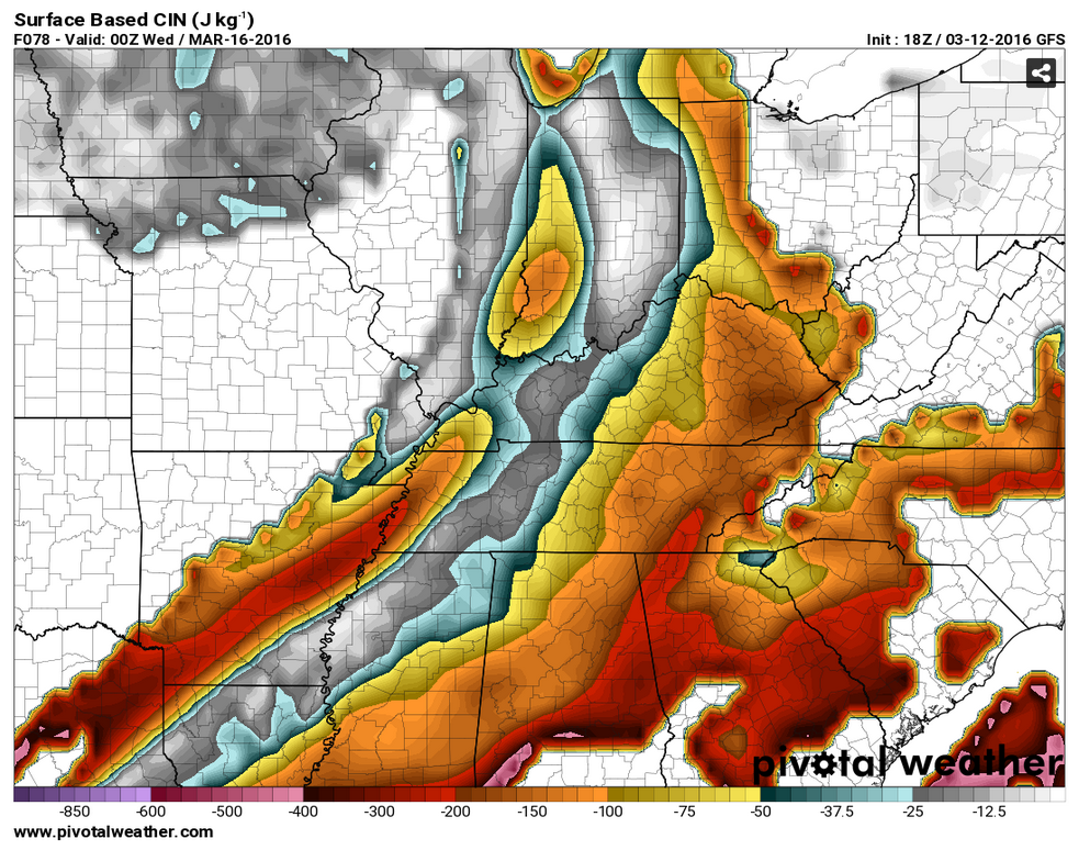
As we move through the afternoon the CAP does weaken a bit. But, will it be enough weakening to allow storms to form? That is the question.
Cooler air arrives behind the cold front on Wednesday into the weekend. Overnight lows on Wednesday night, Thursday night, and Friday night should dip into the upper 30s and lower 40s. Chilly air. But, not extreme.
One fly in the long range ointment will be a cold front on Friday. An area of low pressure is forecast to move in or near our region. If the low moves over our area then we might warm into the 60s. Showers and thunderstorms might accompany this system on Friday afternoon into Saturday morning. Monitor updates. Low confidence on the Friday and Saturday forecast.
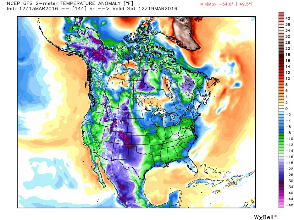
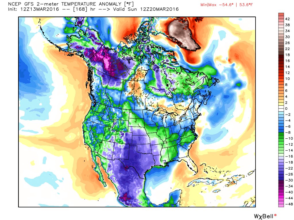
Here are the temperature anomalies for Saturday and Sunday (March 19th and 20th). Below normal temperatures are anticipated for much of the country. The scale is on the right side. Click image for a larger view.
And, here is Sunday

Here are the current river stage forecasts. You can click your state and then the dot for your location. It will bring up the full forecast and hydrograph.

Can we expect severe thunderstorms over the next 24 to 48 hours? Remember that a severe thunderstorm is defined as a thunderstorm that produces 58 mph winds or higher, quarter size hail or larger, and/or a tornado.
.
A few storms could produce strong winds, hail, lightning, and heavy rain on Sunday night. The best chance for heavier storms will be near the MO/AR and KY/TN borders. A small risk for severe thunderstorms. The Sunday night threat level will be a two.

Tuesday:
Another chance for storms will arrive on Tuesday afternoon. There remains some question as to whether storms will be able to form. A warm layer of air aloft, called a CAP, could keep thunderstorm development suppressed. Monitor updates.
.

No major changes in the forecast. I did mention a thunderstorm on Tuesday.
.

The main concern will be continued flooding over northwest Tennessee. Also, a few strong storms are possible Sunday night. Gusty winds, hail, lightning, and brief heavy rain will be possible with the stronger cells. Small risk for severe weather.

Another round of showers and storms possible Sunday night into early Monday morning.

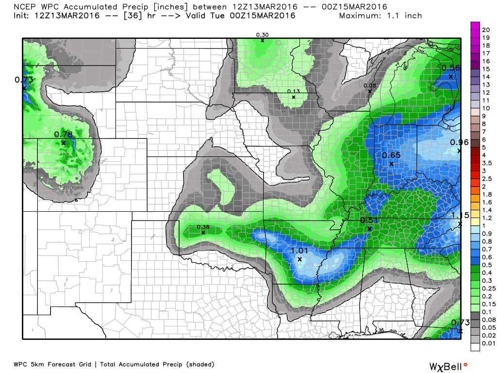
How much precipitation should we expect over the next few days?
Showers and thunderstorms are possible Sunday night into early Monday morning. Precipitation should come to an end on Monday morning.
A few storms are possible on Tuesday. There will be a strong CAP on the atmosphere Tuesday. Storms may struggle to form. A CAP is a warm layer of air aloft. This can prevent vigorous thunderstorm updrafts from forming.
Rainfall totals will vary greatly over the coming 12 hour period. Anywhere from 0.00″ to 0.75″. Thunderstorms can always produce locally higher totals. As we have witnessed over the past week.
Here is the official NOAA rainfall outlook. Again, some places might not receive much.

Here is the official 6-10 day and 8-14 day temperature and precipitation outlook. Check the date stamp at the top of each image (so you understand the time frame).
The forecast maps below are issued by the Weather Prediction Center (NOAA).


The latest 8-14 day temperature and precipitation outlook. Note the dates are at the top of the image. These maps DO NOT tell you how high or low temperatures or precipitation will be. They simply give you the probability as to whether temperatures or precipitation will be above or below normal.


Who do you trust for your weather information and who holds them accountable?
I have studied weather in our region since the late 1970’s. I have 37 years of experience in observing our regions weather patterns. My degree is in Broadcast Meteorology from Mississippi State University and an Associate of Science (AS). I am currently working on my Bachelor’s Degree in Geoscience.
My resume includes:
Member of the American Meteorological Society.
NOAA Weather-Ready Nation Ambassador.
Meteorologist for McCracken County Emergency Management. I served from 2005 through 2015.
I own and operate the Southern Illinois Weather Observatory.
Recipient of the Mark Trail Award, WPSD Six Who Make A Difference Award, Kentucky Colonel, and the Caesar J. Fiamma” Award from the American Red Cross.
In 2009 I was presented with the Kentucky Office of Highway Safety Award.
Recognized by the Kentucky House of Representatives for my service to the State of Kentucky leading up to several winter storms and severe weather outbreaks.
I am also President of the Shadow Angel Foundation which serves portions of western Kentucky and southern Illinois.
There is a lot of noise on the internet. A lot of weather maps are posted without explanation. Over time you should learn who to trust for your weather information.
My forecast philosophy is simple and straight forward.
- Communicate in simple terms
- To be as accurate as possible within a reasonable time frame before an event
- Interact with you on Twitter, Facebook, and the blog
- Minimize the “hype” that you might see on television or through other weather sources
- Push you towards utilizing wall-to-wall LOCAL TV coverage during severe weather events
I am a recipient of the Mark Trail Award, WPSD Six Who Make A Difference Award, Kentucky Colonel, and the Caesar J. Fiamma” Award from the American Red Cross. In 2009 I was presented with the Kentucky Office of Highway Safety Award. I was recognized by the Kentucky House of Representatives for my service to the State of Kentucky leading up to several winter storms and severe weather outbreaks.
If you click on the image below you can read the Kentucky House of Representatives Resolution.

Many of my graphics are from www.weatherbell.com – a great resource for weather data, model data, and more


You can sign up for my AWARE email by clicking here I typically send out AWARE emails before severe weather, winter storms, or other active weather situations. I do not email watches or warnings. The emails are a basic “heads up” concerning incoming weather conditions.