We have our first sponsor for the blog. Milner and Orr Funeral Home and Cremation Services located in Paducah, Kentucky and three other western Kentucky towns – at Milner and Orr they believe in families helping families.
![]()

This forecast update covers far southern Illinois, far southeast Missouri, and far western Kentucky. See the coverage map on the right side of the blog.
Remember that weather evolves. Check back frequently for updates, especially during active weather.
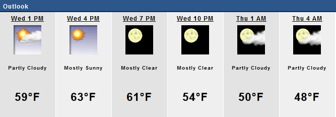
Wednesday – Patchy morning fog. Some clouds today and it will be mild – spring like. Clearing is likely during the late morning or afternoon hours. Bring on the sun! Highs well into the 50’s and perhaps some lower 60’s. Can’t beat that! Northeast winds – light. My confidence in this part of the forecast verifying is high
Morning School Bus Stop Weather – Some clouds. Temperatures mainly in the 40’s. Northeast winds at 10 mph. Chances of schools being delayed because of the weather low.
—————————————————————————————-
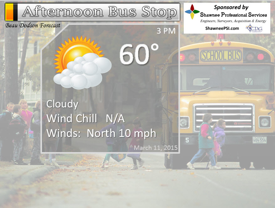
Afternoon School Bus Stop Weather – Mix of sun and clouds. Temperatures in the upper 50’s to lower 60’s with northeast winds at 5-10 mph.
Wednesday night – Some clouds. Lows mainly in the 40’s. North/northeast winds at 5-10 mph. My confidence in this part of the forecast verifying is medium
Thursday– Cloudy. Rain chances increase through the day from the south. Mild – spring like. Highs in the 60’s. East/Northeast winds at 5 mph. My confidence in this part of the forecast verifying is high
Thursday night – Rain likely. Rumbles of thunder possible. Lows in the 40’s. East/Northeast winds at 5-10 mph. My confidence in this part of the forecast verifying is high
Friday – Cloudy with some rain likely. Rumbles of thunder possible. Mild with highs in the lower 60’s. East winds becoming north/northwest towards evening at 10 mph. My confidence in this part of the forecast verifying is medium
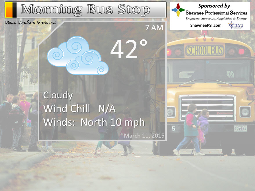
The School Bus Stop Forecast is brought to your by Shawnee Professional Services. For more information click here

Current Temperatures Around The Local Area


An explanation of what is happening in the atmosphere over the coming days…
Highlights…
1. Dry today
2. Moderate to heavy possible Thursday evening into Friday evening
3. Widespread 1″-2″ of rain (maybe more for some counties) likely
4. Flood watches may need to be issued for parts of our region for this next week
5. Rivers continue to rise (see the flood section)
Our soggy Tuesday will turn into a dry Wednesday. We could use some dry down time, but no rest for the weary. Our next storm system is already taking shape and will bring precipitation chances back by Thursday. We may even hear some rumbles of thunder. Not expecting severe weather.
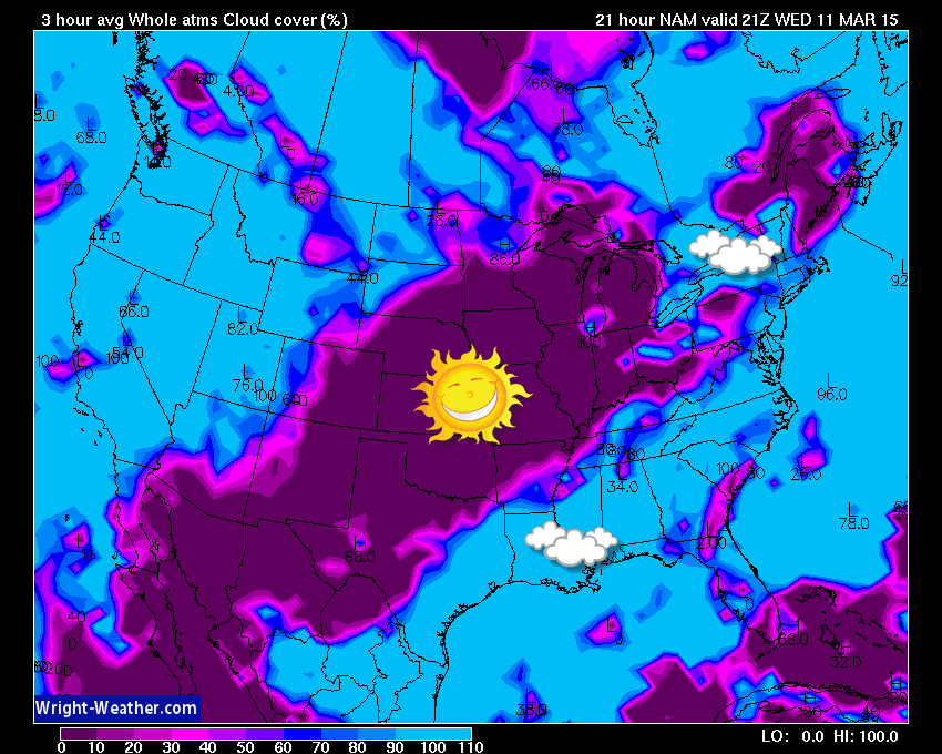
Let’s check out cloud cover for Wednesday. The blue area would be cloudy sky conditions. The purple would be clearing. That clearing line will move west to east on Wednesday.
10 AM Map
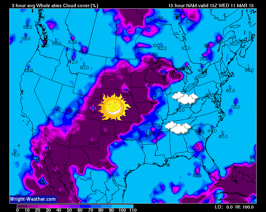
4 PM Map
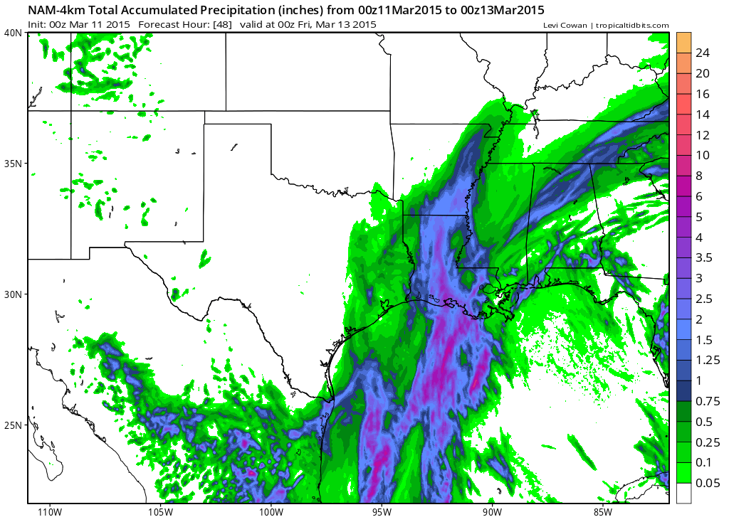
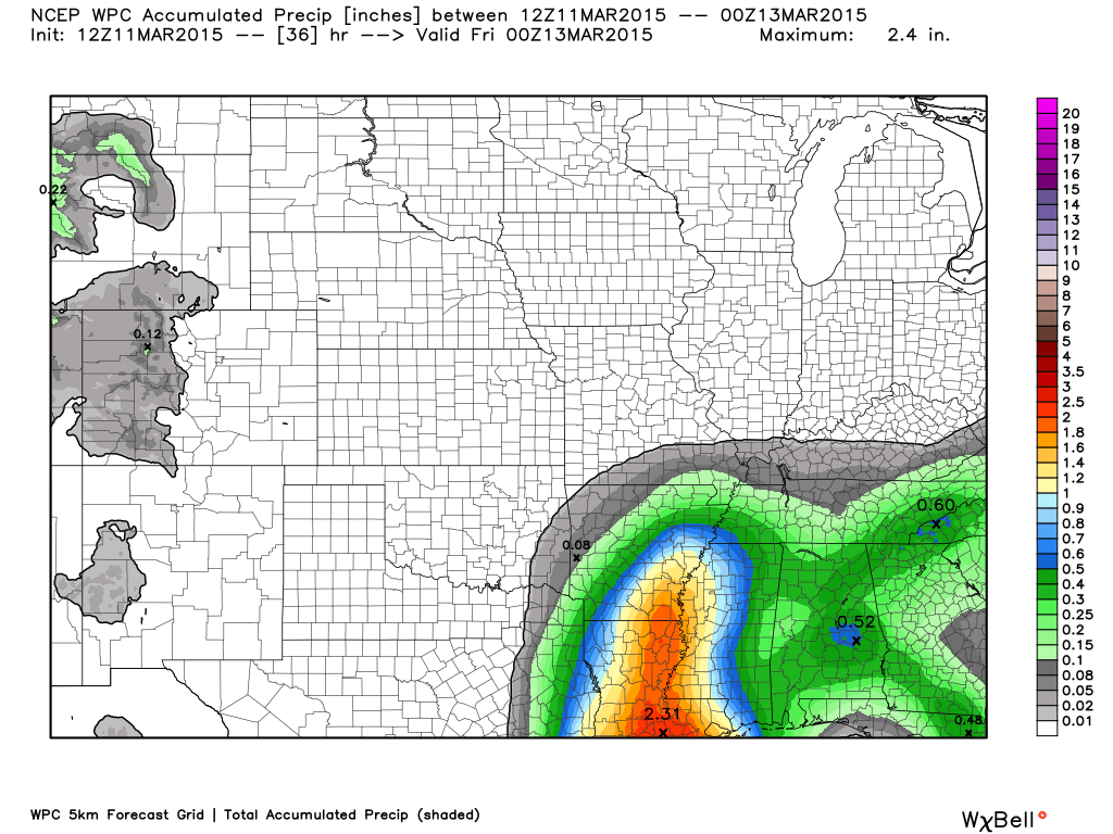
Widespread rainfall totals of 1.00″ – 2.00″ are likely going to occur in the region. There remains some question on the exact track of the area of low pressure. That is going to be key to where the heaviest rain band sets up shop. No matter where the rain falls, it will be an unwelcome rain. The ground is super-saturated, streams and ditches have a lot of water in them, rivers are rising, and additional rain will exacerbate the problems.
Some training of showers and even thunderstorms will be possible with this event. If that occurs then there could be some pockets of flooding. This will need to be monitored. Training is where heavier precipitation moves over the same area repeatedly.
The 1″-2″ is a rough idea of rainfall totals. I will try to narrow it down a bit more on the next update.
The good news is that we may see a break from the rain after this next system. At least for a bit. It is spring and spring does bring rain and thunderstorms, so obviously there will be more to come.
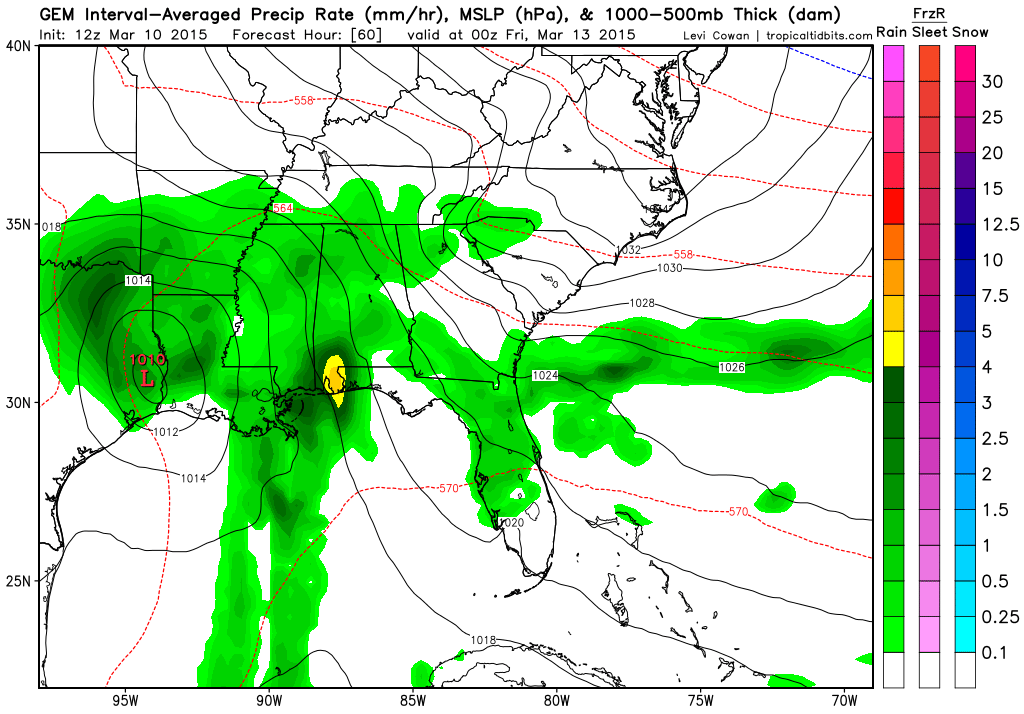
Let me show you the Canadian model and how it brings the rain into our region. Green colors would be rain.
You can see the red L on the Texas and Louisiana coastline. That is the area of low pressure that will move north. LOT of moisture with this system. Any system that comes out of the Gulf of Mexico is going to produce quite a bit of rain.
This is Thursday late afternoon and evening. Rain is knocking on our door or could already be moving into southern counties.
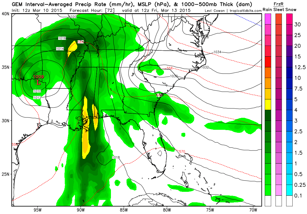
This is the Friday morning weather map. The area of low pressure is located near the Texas, Oklahoma, and Arkansas border. A bit odd to see a system move straight out of the Gulf of Mexico (this time of the year).
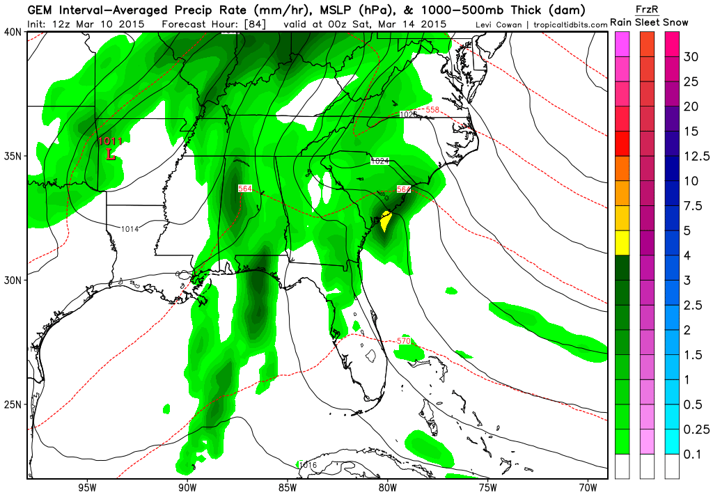
This is the Friday evening weather map. Still a lot of green in our area. This is a big concern. Water soaked grounds do not need this kind of rain. Flood watches may need to be issued for parts of our area.
The high resolution NAM model brings rain into the Missouri Bootheel, northwest Tennessee, and parts of west Kentucky as early as 3 pm to 5 pm on Thursday.
7 PM Precipitation totals according to the high resolution NAM model. You can see some precipitation already in parts of our area by that time. So, keep that in mind. We may have rain before sunset in some of our counties.
Let’s take a look at rainfall from the NAM model – weatherbell.com image
Different models and forecasts paint different rainfall totals. What most of them have in common is that they are showing quite a bit of additional rain on Thursday evening into Friday afternoon. Some data lingers precipitation into Saturday morning, as well. Light.
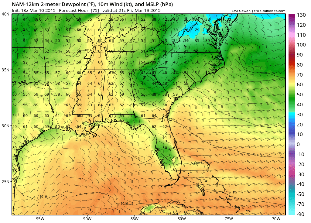
It has been awhile since we have had to talk about dew points. Once we have dew points of 60 and above then the atmosphere starts to feel humid. The higher the dew point the more moisture that is in the air. The more moisture that is in the air means the chances for heavy rainfall rises. We can see the dew points on Friday will be rising above 60 degrees. You can even see some middle 60’s over west Tennessee.
Bottom line…some moderate to heavy rain is likely to occur Thursday night into Friday. We may have to deal with some flooding.
Speaking of spring weather…
For those new to the Beau Dodson Weather Facebook page and the blog – during severe thunderstorm outbreaks I will post 3 hour now-cast threads on the Facebook page (not expecting any severe weather this week). These are similar to the snow storm threads. In those threads I will post updates as to how the storms are evolving and what you can expect. You can also ask questions within those threads. I don’t normally post warnings (unless something major is happening). You should have a NOAA Weather Radio for your warnings (I recommend the Midland 300 model). You can also find weather warning app’s online.
A major cold snap is likely the week of the 20th and into the following week, perhaps. More record cold for some? We will have to wait and see. See the extended discussion below.
Don’t forget that I am trying to get people to sign up for a small monthly donation. A lot of people are giving between $2-$5. If I can build this base then it will help cover my costs and the time I put into all of this. I do not work for a TV or radio station. It does cost a lot of money to bring you this weather information on a daily basis.
The subscribe button.
We have some flood warnings in the region. You can view those by clicking on this map and drilling down to your local county.


No significant changes to the on-going forecast numbers. Some debate on timing of precipitation Thursday. I think most areas will start picking up rain on Thursday night. We may see some showers moving into the Missouri and Arkansas border area and the Kentucky and Tennessee border area by evening.

All of this rain is a concern. If nothing else this will keep river levels higher for a longer period of time. I suspect it will also mean some adjustments upward in river crest levels. So far this has not be a severe flood, but if we keep receiving heavy rain then it certainly could evolve into something a bit more serious. The overall pattern favors the sub-tropical jet to remain active.
I do see a break next week perhaps as cold weather returns. If the cold returns then that would tend to mean drier weather for a bit (assuming we don’t get another snow fall on top of all of this). I am telling people winter isn’t over…at least the cold. Whether we see additional snow, nobody knows that, yet.
Check out our sponsors! There are more on the right side bar of the page, as well. Be sure and let them know that you appreciate their sponsorship of the WeatherTalk daily weather bulletin.
How about a $5 meal deal? The DQ Grill and Chill (located across from Noble Park in Paducah, Kentucky) is the newest WeatherTalk Blog sponsor! A local business helping to sponsor the weather information that you have come to love so much.
Check out their Facebook page for specials, as well DQ Grill and Chill on Facebook


Premier Portable Buildings proudly serving our region. For more information click the above ad or here
They can also be found on this Facebook page

G&C Multi-Services out of Paducah, Kentucky. G & C Multi-Services is a service provider in Western Kentucky that provides industrial and commercial equipment fabrication, machine troubleshooting, repair and maintenance, and installation. They can custom fabricate steel, stainless, and aluminum products per customer specifications.
Visit their web-site here. Or click the ad below! Facebook page.

Wortham Dental Care located in Paducah, Kentucky. The gentle dentist. Mercury free dentistry. They also do safe Mercury removal. You can find Wortham Dental Care on Facebook, as well

Trover’s Equipment and Lawn Care – Family owned and operated! They are a dealer for Snapper, Simplicity, Snapper Pro, Bad Boy Mowers, and Intimidator Utility Vehicles. They are a Stihl and Dolmar power products dealer. They also are a dealer for Briggs & Stratton, Kohler gas & diesel engines, and Kawasaki engines. They service and repair just about any brand. You can find them on Facebook, as well

Shawnee Professional Services & Civil Design Group have been providing Land Surveying, Engineering, Grant Administration and Acquisition services for the past 20 years. Currently Licensed in Illinois, Kentucky, Missouri, Indiana, and Tennessee; please contact Shawnee for any Land Surveying or Engineering needs. Shawnee’s company size allows them to devote individual attention to each client and to approach each project with the required thoroughness to successfully complete the project, large or small. Visit Shawnee’s website at shawneepsi.com for more information. Shawnee has offices in Paducah, KY, Vienna, IL and Benton, IL.

Can we expect severe thunderstorms over the next 24 to 48 hours? Remember that a severe thunderstorm is defined as a thunderstorm that produces 58 mph winds or higher, quarter size hail or larger, and/or a tornado.
Thunderstorm threat level is ONE. This is for Thursday night and Friday.


Rivers continue to rise. Don’t expect them to fall off anytime soon, either. We have Tuesday’s rain to drain into the system and then we have another widespread mod to heavy rain event for Thursday and Friday. Expect some adjustments in the river crest levels.
Here are the current river stage forecasts. You can click your state and then the dot for your location. It will bring up the full forecast and hydrograph.
Here are some current forecast hydrographs. These will be updated each day with new information.

Shawneetown, Illinois

Paducah, Kentucky Forecast Stage

Cairo, Illinois

Will I need to take action?
Dry weather today. Umbrellas will be needed again towards Thursday evening and into Friday.

How much precipitation should we expect over the next few days?
Another round of moderate to heavy rain is likely as we move into Thursday evening and Friday. We do not need this rain.
The bulk of this event arrives Thursday night and Friday.
Here are the rainfall totals through 7 pm on Thursday. You can see the rain is edging northward. Images are from weatherbell.com and you can click the image for a larger view.
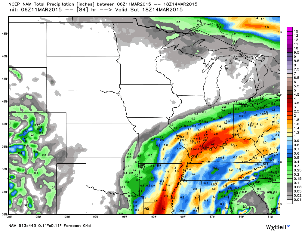
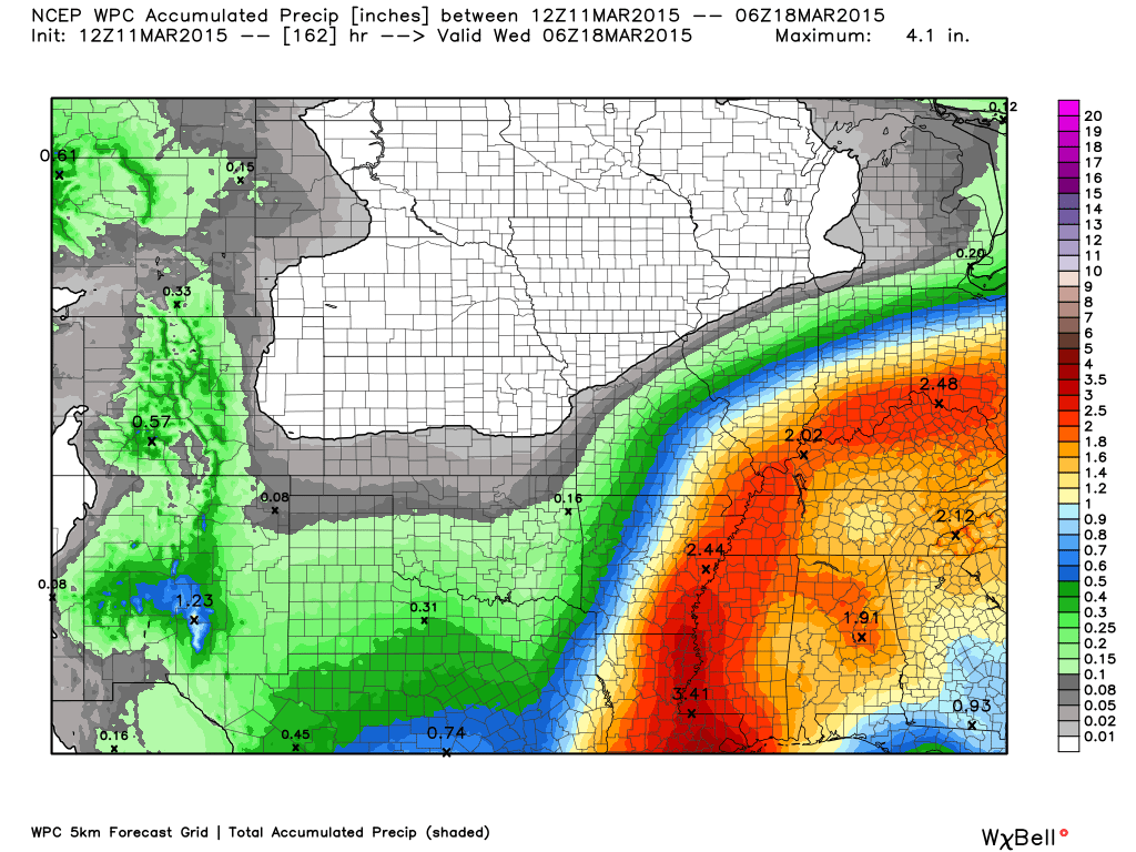
Let’s take a look at rainfall totals through Saturday morning. Quite a bit of rain, once again.

I don’t have any winter weather in the forecast!
Jim Rasor has a new blog. Check it out when you have time http://mylocalweather.net/forum/home

This section of the blog is speculative forecast information. Because it is past the range of what meteorologists can forecast accurately, it should be considered speculation. Anything past day 5 is considered a long range forecast.
Let’s look beyond this weekend.
I have been watching for the potential of a lot of cold weather as we push towards the end of next week and into the following week. A lot of meteorologists are picking up on these signals.
Whether we get moisture into the cold air is questionable. But, it will just need to be monitored as we move forward.
We should see decent temperatures Saturday and Sunday and then into early next week. If the cold air returns then it would be later in the week.
The weekend should be mostly dry. Data does spit out a few showers on Saturday morning. I will monitor that part of the forecast. Hopefully we can get away with a mostly dry weekend.
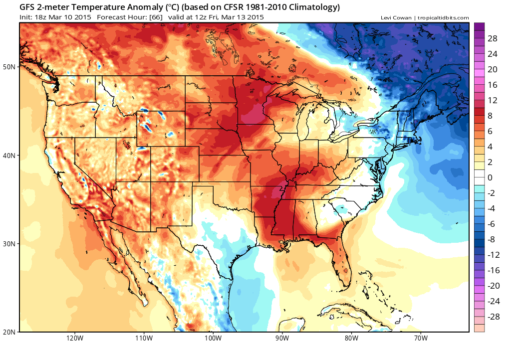
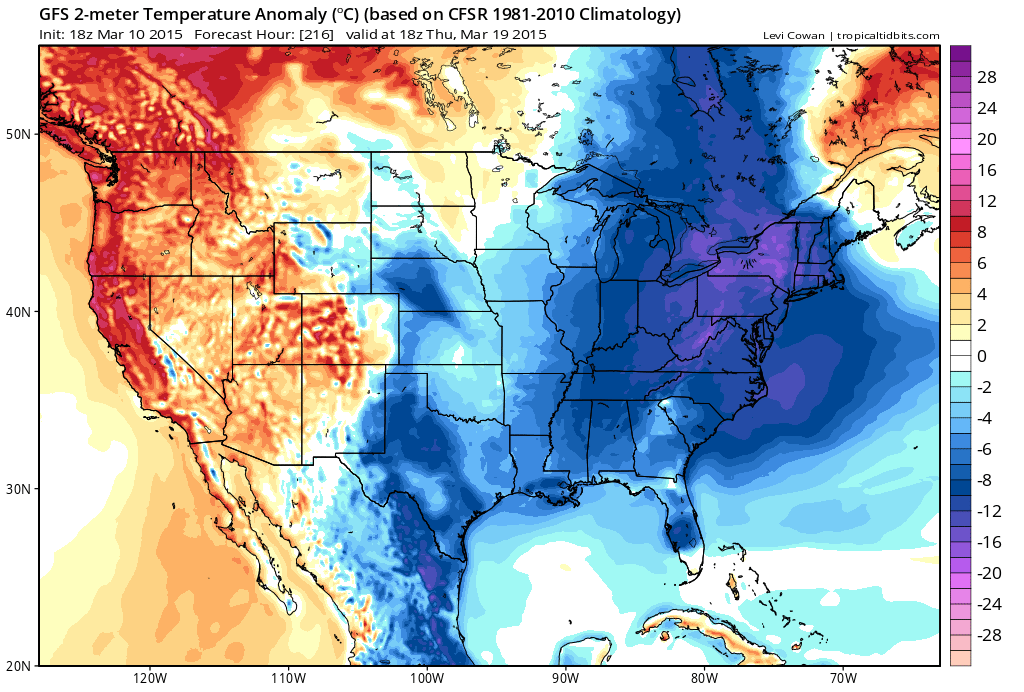
Let’s compare Fridays anomalies vs next Thursday. This map shows you how much above or below normal temperatures will be.
This is Friday – ABOVE normal!
Now, let’s look at next Thursday. Blue colors mean below normal temperatures.

We have regional radars and local city radars – if a radar does not seem to be updating then try another one. Occasional browsers need their cache cleared. You may also try restarting your browser. That usually fixes the problem. Occasionally we do have a radar go down. That is why I have duplicates. Thus, if one fails then try another one.
If you have any problems then please send me an email beaudodson@usawx.com
WEATHER RADAR PAGE – Click here —
We also have a new national interactive radar – you can view that radar by clicking here.
Local interactive city radars include St Louis, Mt Vernon, Evansville, Poplar Bluff, Cape Girardeau, Marion, Paducah, Hopkinsville, Memphis, Nashville, Dyersburg, and all of eastern Kentucky – these are interactive radars. Local city radars – click here
NOTE: Occasionally you will see ground clutter on the radar (these are false echoes). Normally they show up close to the radar sites – including Paducah.

Regional Radar – Click on radar to take you our full radar page.


Regional Radar

Live Lightning Data – zoom and pan: Click here
Live Lightning Data with sound (click the sound button on the left side of the page): Click here
![]()
Current WARNINGS (a warning means take action now). Click on your county to drill down to the latest warning information. Keep in mind that there can be a 2-3 minute delay in the updated warning information.
I strongly encourage you to use a NOAA Weather Radio or warning cell phone app for the most up to date warning information. Nothing is faster than a NOAA weather radio.


Color shaded counties are under some type of watch, warning, advisory, or special weather statement. Click your county to view the latest information.

Missouri Warnings

Illinois Warnings

Kentucky Warnings

Please visit your local National Weather Service Office by clicking here. The National Weather Service Office, for our region, is located in Paducah, Kentucky. They have a lot of maps and information on their site. Local people…local forecasters who care about our region.


Who do you trust for your weather information and who holds them accountable?
I have studied weather in our region since the late 1970’s. I have 37 years of experience in observing our regions weather patterns. My degree is in Broadcast Meteorology from Mississippi State University and an Associate of Science (AS). I am currently working on my Bachelor’s Degree in Geoscience. Just need to finish two Spanish classes!
I am a member of the American Meteorological Society. I am a NOAA Weather-Ready Nation Ambassador. And, I am the Meteorologist for McCracken County Emergency Management.
I own and operate the Southern Illinois Weather Observatory.
There is a lot of noise on the internet. A lot of weather maps are posted without explanation. Over time you should learn who to trust for your weather information.
My forecast philosophy is simple and straight forward.
- Communicate in simple terms
- To be as accurate as possible within a reasonable time frame before an event
- Interact with you on Twitter, Facebook, and the blog
- Minimize the “hype” that you might see on television or through other weather sources
- Push you towards utilizing wall-to-wall LOCAL TV coverage during severe weather events
I am a recipient of the Mark Trail Award, WPSD Six Who Make A Difference Award, Kentucky Colonel, and the Caesar J. Fiamma” Award from the American Red Cross. In 2009 I was presented with the Kentucky Office of Highway Safety Award. I was recognized by the Kentucky House of Representatives for my service to the State of Kentucky leading up to several winter storms and severe weather outbreaks.
If you click on the image below you can read the Kentucky House of Representatives Resolution.

I am also President of the Shadow Angel Foundation which serves portions of western Kentucky and southern Illinois.
Many of my graphics are from www.weatherbell.com – a great resource for weather data, model data, and more


This blog was inspired by ABC 33/40’s Alabama Weather Blog – view their blog
Current tower cam view from the Weather Observatory- Click here for all cameras.

Southern Illinois Weather Observatory

The Weather Observatory

Southern Illinois Weather Observatory
WSIL TV 3 has a number of tower cameras. Click here for their tower camera page & Illinois Road Conditions

Marion, Illinois
WPSD TV 6 has a number of tower cameras. Click here for their tower camera page & Kentucky Road Conditions & Kentucky Highway and Interstate Cameras

Downtown Paducah, Kentucky
Benton, Kentucky Tower Camera – Click here for full view

Benton, Kentucky

I24 Paducah, Kentucky

I24 Mile Point 9 – Paducah, KY

I24 – Mile Point 3 Paducah, Kentucky

You can sign up for my AWARE email by clicking here I typically send out AWARE emails before severe weather, winter storms, or other active weather situations. I do not email watches or warnings. The emails are a basic “heads up” concerning incoming weather conditions.