We have our first sponsor for the blog. Milner and Orr Funeral Home and Cremation Services located in Paducah, Kentucky and three other western Kentucky towns – at Milner and Orr they believe in families helping families. You can find Milner and Orr on Facebook, as well.
![]()

This forecast update covers far southern Illinois, far southeast Missouri, and far western Kentucky. See the coverage map on the right side of the blog.
Remember that weather evolves. Check back frequently for updates, especially during active weather.
Thursday – Increasing clouds. Some morning dense fog in spots. Showers possible as the day wears on. Spring like temperatures into the 60’s. Northeast winds at 5-10 mph. My confidence in this part of the forecast verifying is high
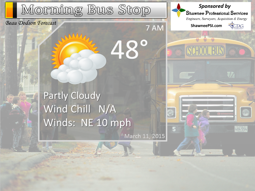
Morning School Bus Stop Weather – Partly sunny and cool. Temperatures in the 40’s. Light winds. Chances of schools being delayed because of the weather zero.
—————————————————————————————-
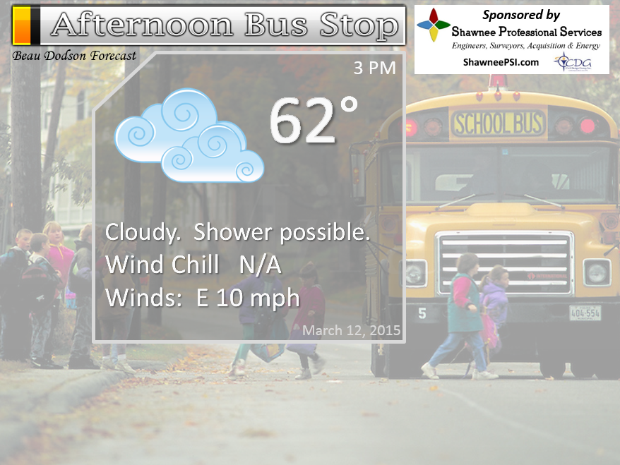
Afternoon School Bus Stop Weather – Cloudy with a shower possible. Mild. Temperatures in the 60’s with light winds.
Thursday night – Mostly cloudy with rain likely. A chance for a rumble of thunder. Lows will be in the 50’s. East winds at 10 mph – winds turning southeast towards morning. My confidence in this part of the forecast verifying is high
Friday – Rain likely with a chance for thunder. Some heavy downpours possible, as well. Mild. Highs into the 60’s. South winds at 10-15 mph. My confidence in this part of the forecast verifying is medium
Friday night – Rain showers likely. Lows in the 50’s. Southwest winds at 10 mph. My confidence in this part of the forecast verifying is medium
Saturday – Cloudy with some lingering showers possible. Highs in the upper 50’s to lower 60’s. Winds mostly from the north at 10 mph. My confidence in this part of the forecast verifying is medium
Latest data lingers rain a bit longer on Saturday.
School Bus Stop Forecast
The School Bus Stop Forecast is brought to your by Shawnee Professional Services. For more information click here

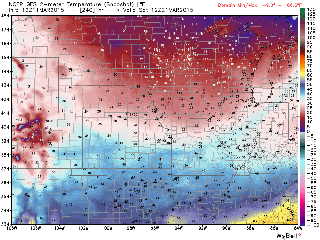
Current Temperatures Around The Local Area


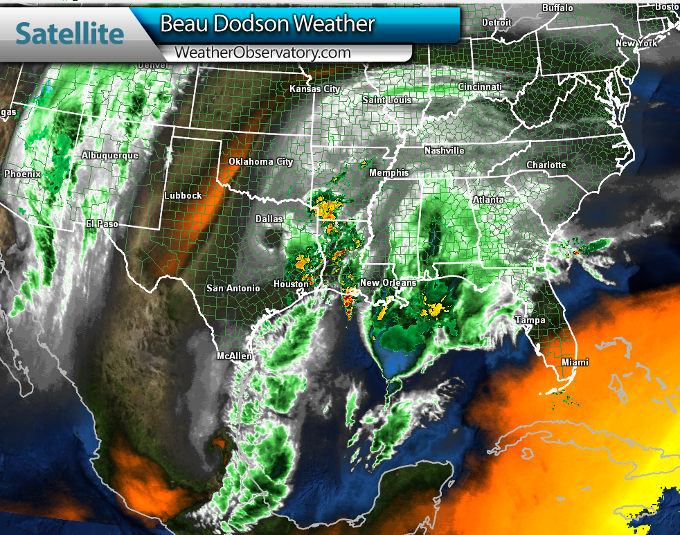
You can see our system forming down in the Gulf of Mexico. A bit odd for early March.

Water Vapor – watch the moisture to our south and southwest. That will be streaming in here tonight into Friday night.


An explanation of what is happening in the atmosphere over the coming days…
Here comes the rain, again. Starting to sound like a broken record with the rain in the forecast. The good news is that this will be the last heavy rain event for a little while. Of course, spring is knocking on our door and that means more storms down the road. But, for now we just have to get through this event.
Here is the radar link so you can track the rain on Thursday afternoon and evening

We have regional radars and local city radars – if a radar does not seem to be updating then try another one. Occasional browsers need their cache cleared. You may also try restarting your browser. That usually fixes the problem. Occasionally we do have a radar go down. That is why I have duplicates. Thus, if one fails then try another one.
WEATHER RADAR PAGE – Click here —
We also have a new national interactive radar – you can view that radar by clicking here.
Local interactive city radars include St Louis, Mt Vernon, Evansville, Poplar Bluff, Cape Girardeau, Marion, Paducah, Hopkinsville, Memphis, Nashville, Dyersburg, and all of eastern Kentucky – these are interactive radars. Local city radars – click here
NOTE: Occasionally you will see ground clutter on the radar (these are false echoes). Normally they show up close to the radar sites – including Paducah.

Concerns…
My main concern is flooding. I told you that I suspected flood watches would be issued for the area. And, they have been. Aerial flood watches and flood watches cover most of the local area. They run from Thursday night through early Saturday morning.
You can read the text of the watches by clicking here and drilling down to your county…Watches and Warnings
Rainfall will be on the heavy side, especially on Friday. Some rumbles of thunder can’t be ruled out. Best chance for thunder will be near the AR/MO border and then into the KY/TN border areas. Maybe a little north of there. No severe thunderstorms. That is great news. But, thunderstorms could enhance rainfall totals in a few counties.
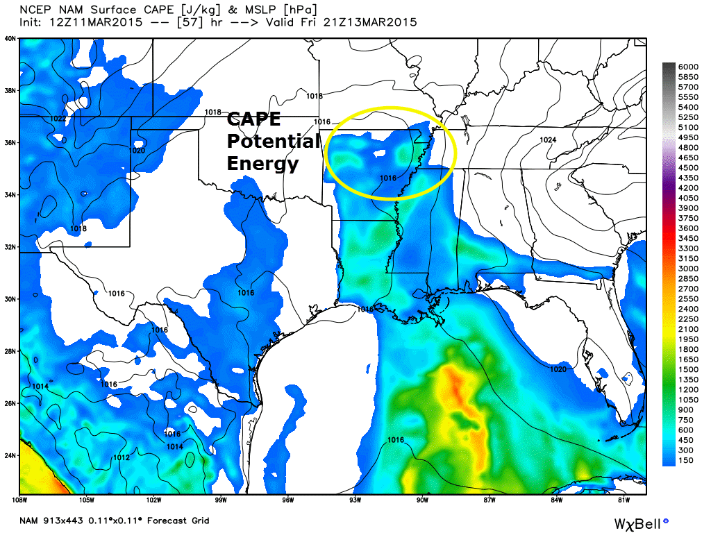
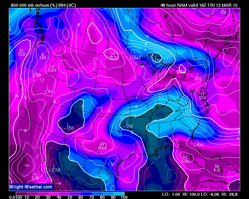
Let’s look at CAPE values. This is another term you should get used to hearing. CAPE is how meteorologists measure energy in the atmosphere. The higher the number usually means the more potential for the atmosphere to produce thunderstorms. Of course there are a bunch of other variables that go into producing storms. CAPE is one measure of energy. More about what CAPE means.
You can see the blue colors creeping into parts of our area on Friday (southern Missouri and the Missouri Bootheel). What does that mean for you and me? It means that there could be a few isolated rumbles of thunder. We are missing other ingredients, for severe weather. The problem with thunderstorms will be enhanced rainfall totals…where they occur. Most likely the MO/AR border area and perhaps KY/TN border areas and southward.
I also like to look at lifted index values. That tells me a little bit more about how much lift is in the atmosphere. Once we get into the negative range then I start to thinking about thunderstorms, as well. The dark area/hatched would be 0 to negative lift index numbers. This is for 7 am on Friday. See how they creep into our area?
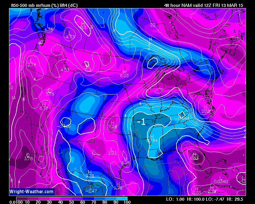
Later in the day – Again, the dark shaded area is negative numbers or approaching negative. I checked the soundings and they showed mostly near to above 0. Either way, the parameters are there for a few thunderstorms. Not worried about severe weather. More concerned about enhanced rainfall totals.
There is a great disconnect in the model data as to where to place the heaviest rainfall. The high resolution data is keeping parts of western Kentucky and western Tennessee in lesser totals.
The TREND has been west. This system a few days ago was forecast to produce the heaviest rains from central Kentucky into west Tennessee. With each passing 12 hour period the data kept shifting it further and further west.
As a forecaster I can’t help but take note of this westward trend. The main concern is that it really impacts how much rain will fall in our area. The heaviest band keeps shifting west. This lowers my confidence as to how much rain falls in our area. I feel that the placement of the heaviest rain axis will be over Arkansas into Missouri and Illinois. The only question is how far east to place this band.
The warm front is going to be key as to where the heavier rain falls. Areas along and north of the front will experience the most rain. The warm front will push into the Missouri Bootheel and west Kentucky on Friday. This will place an enhanced area of rainfall over some of our counties.
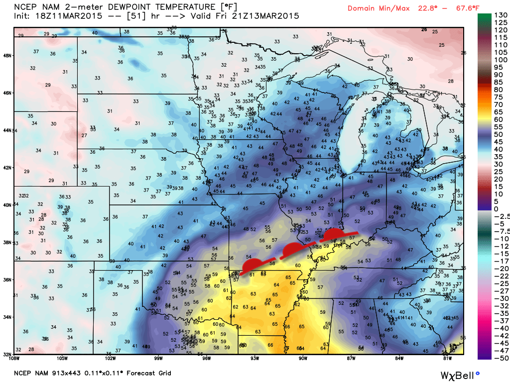
Here is the dew point map. Forecasters use the dew point to determine how much moisture is in the air. You can see those yellow colors…those represent higher dew points. Once we get into spring we should keep an eye on dew points. They are a factor in severe weather development. The good news, again, is that severe storms won’t be a concern with this particular event.
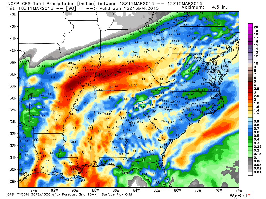
Right now I am forecasting the heaviest rain totals to be across northern Arkansas into southern and southeast Missouri and then into southern Illinois. Rainfall totals could be in the 1-3″ range in those areas.
For western Kentucky and Tennessee the forecast is for widespread 0.75″-1.50″ totals. Any shift in the track of the area of low pressure and warm front could increase those totals. I am a little concerned (concerned in the aspect of an accurate forecast) about one high resolution model showing very little rain over parts of KY/TN. It has been consistently showing this. This is because of how it tracks the area of low pressure and the best lift.
For now, we will go with the widespread rain totals mentioned above. If something changes then I will update.
Rivers and streams/creeks are high. We do not need this rain. Expect some flash flooding or flooding issues in those areas that often have problems.
This does not look to be one of those events were the flooding becomes crazy in areas that don’t usually flood. If your area normally has some water issues during moderate to heavy rain, then you may have problems with this event.
Avoid flooded roadways, as always. Also be sure and report flooded roadways to local law enforcement and transportation departments.
Let’s walk you through some maps
All of the maps are click-able and can be enlarged.
First off, let’s find the system. Check it out! Down there in the Gulf of Mexico. This is an odd track for March. We don’t typically see a storm come out of the Gulf of Mexico and head north…not in March. But, that is what is going to happen.
This is the water vapor satellite image. You can see all of the high level moisture down in Texas, Louisiana, Mississippi, and Alabama. This is coming north. Look at that moisture feed straight down into the Gulf of Mexico. Amazing.
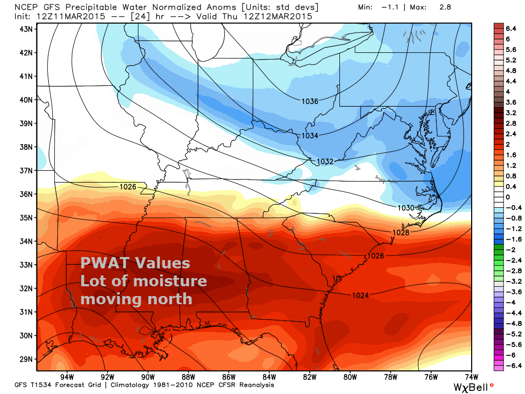
Now let me show you PWAT values. If you follow my blog then you need to learn what PWAT means. It is precipitable water values. How much moisture is in the air. The higher the numbers, the higher the risk for moderate to heavy rain.
This system is going to be loaded up with moisture. These are the anomalies. Red means well above normal values.
This first map is for Thursday morning around 7 am. See all of the dark red to our south? That is our system spreading northward. Let’s walk through the rest of the day into Friday on the maps that follow.
Watch how that red area spreads northward on Thursday night and Friday. This is Thursday evening. It has definitely spread north. That means the atmosphere is becoming juiced up.
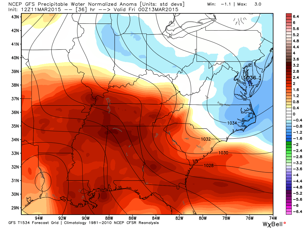
Moving into Friday – lot of red. Lot of moisture. A sustained period of high PWAT values. That is a signal that meteorologists look for when it comes to locally moderate to heavy rain.
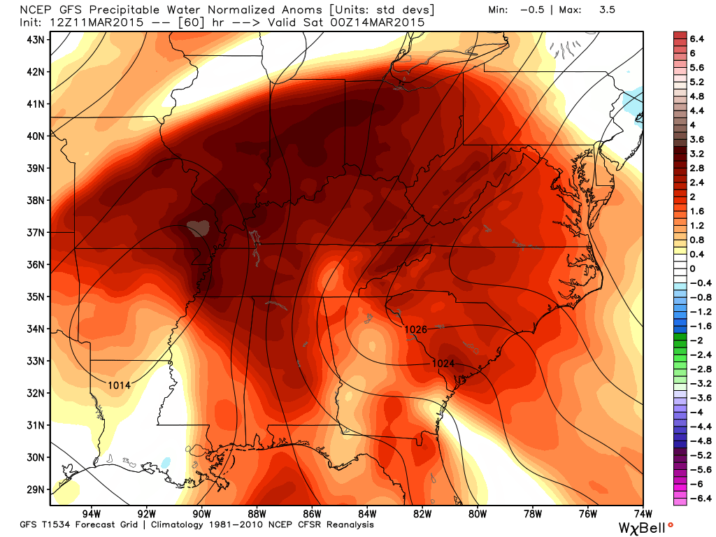
We might see some training of rain showers. If that occurs then pockets of heavier totals will occur. This is a bit of an odd system. The way it will move. This leads me to believe that some areas could see repeated moderate to heavy showers.
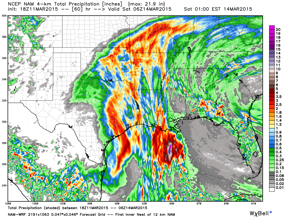
Let’s look at rainfall totals (images are from weatherbell.com). These are a bunch of the models that I look at each day. What has been occurring over the past 3 days is a westward shift in the track of this system. The NAM first picked up on this (a great model). The GFS has been HORRIBLE lately. Terrible model in the short range. Not sure why anyone uses it for short range forecasting. It has been wrong with just about every event for the past 2 months. NAM has been superior in the short range. Anyway, sorry – soap box moment.
I mentioned above that one high resolution model was showing a lack of rain over parts of Kentucky and Tennessee. This is a bit odd, but it has been showing this for the past 4 or 5 runs. You can see the heaviest totals from Missouri into Illinois.
This is the WRF/NAM. I am curious to see if future runs of this model change it’s idea on the area of lesser totals. I just wanted to show you this. If it does end up being correct then I will give it a shout out in Saturday’s update! By then we will know how it all panned out.
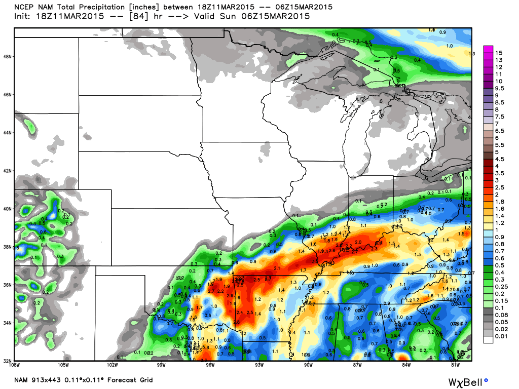
Moving on…let’s look at the operational NAM model. You can see widespread rain in our region. Heaviest totals from Arkansas into part of west Tennessee and then in Missouri and Illinois. Lot of rain everywhere else, as well. The red are the heaviest totals.
Here is the GFS model. It has finally caught on that this system is going to be further west. It also shows the heavy totals from Arkansas into Missouri and then into our area. It has been shifting west. We will see how far west the heaviest totals end up.
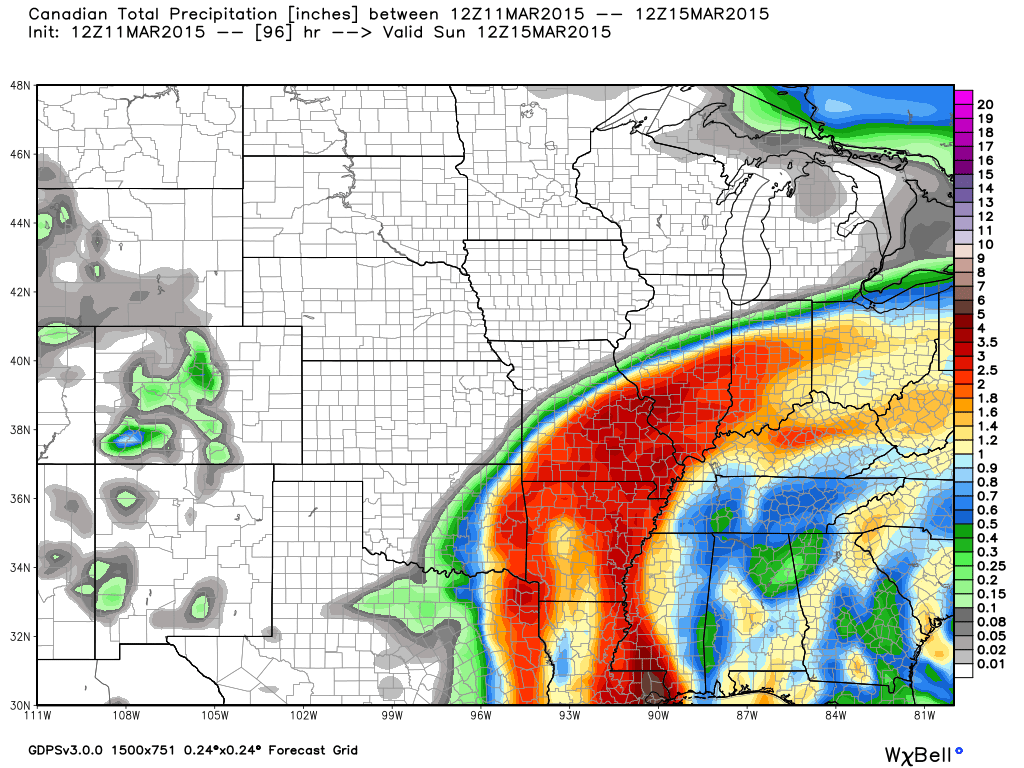
The Canadian GEM model. You get the idea. Lot of rain is forecast for our region on Thursday night into Saturday morning. You also can see the general idea that all the data places the heaviest totals north and west of the Ohio River and along the Mississippi River.
The Weekend…
Latest data lingers rain a bit longer on Saturday. I will monitor this part of the forecast. Otherwise, high temperatures on Saturday and Sunday will be seasonable. Highs in the 50’s and/or 60’s.
Sunday will be dry.
Monday will be dry.
Tuesday will be dry.
Would you like to help support my forecasting efforts?
Don’t forget that I am trying to get people to sign up for a small monthly donation. A lot of people are giving between $2-$5. If I can build this base larger then it will help cover my costs and the time I put into all of this. I do not work for a TV or radio station.
The subscribe button.

Updated rain chances for today. Showers already moving into the Missouri Bootheel and southern Missouri.

Flooding is the concern. We do not need more rain. We are going to get more rain. Locally heavy rainfall totals could cause streams to overflow their banks. Overland flooding is also possible. If you live in a flood prone area then you will want to monitor the situation.
Advisory map – click on your county to read the text

Check out our sponsors! There are more on the right side bar of the page, as well. Be sure and let them know that you appreciate their sponsorship of the WeatherTalk daily weather bulletin.
How about a $5 meal deal? The DQ Grill and Chill (located across from Noble Park in Paducah, Kentucky) is the newest WeatherTalk Blog sponsor! A local business helping to sponsor the weather information that you have come to love so much.
Check out their Facebook page for specials, as well DQ Grill and Chill on Facebook


Premier Portable Buildings proudly serving our region. For more information click the above ad or here
They can also be found on this Facebook page
G&C Multi-Services out of Paducah, Kentucky. G & C Multi-Services is a service provider in Western Kentucky that provides industrial and commercial equipment fabrication, machine troubleshooting, repair and maintenance, and installation. They can custom fabricate steel, stainless, and aluminum products per customer specifications.
Visit their web-site here. Or click the ad below! Facebook page.


Wortham Dental Care located in Paducah, Kentucky. The gentle dentist. Mercury free dentistry. They also do safe Mercury removal. You can find Wortham Dental Care on Facebook, as well

Trover’s Equipment and Lawn Care – Family owned and operated! They are a dealer for Snapper, Simplicity, Snapper Pro, Bad Boy Mowers, and Intimidator Utility Vehicles. They are a Stihl and Dolmar power products dealer. They also are a dealer for Briggs & Stratton, Kohler gas & diesel engines, and Kawasaki engines. They service and repair just about any brand. You can find them on Facebook, as well
The School Bus Stop Forecast is brought to your by Shawnee Professional Services. For more information click here

Shawnee Professional Services & Civil Design Group have been providing Land Surveying, Engineering, Grant Administration and Acquisition services for the past 20 years. Currently Licensed in Illinois, Kentucky, Missouri, Indiana, and Tennessee; please contact Shawnee for any Land Surveying or Engineering needs. Shawnee’s company size allows them to devote individual attention to each client and to approach each project with the required thoroughness to successfully complete the project, large or small. Visit Shawnee’s website at shawneepsi.com for more information. Shawnee has offices in Paducah, KY, Vienna, IL and Benton, IL.

Rivers continue to rise. Don’t expect them to fall off anytime soon, either.
The good news is that after this rain event we should see a period of dry weather into early next week. Much needed, I might add!
Here are the current river stage forecasts. You can click your state and then the dot for your location. It will bring up the full forecast and hydrograph.
Here are some current forecast hydrographs. These will be updated each day with new information.

Shawneetown, Illinois

Paducah, Kentucky Forecast Stage

Cairo, Illinois

Flood prone areas will want to monitor water levels.
Otherwise, umbrella weather!

Can we expect severe thunderstorms over the next 24 to 48 hours? Remember that a severe thunderstorm is defined as a thunderstorm that produces 58 mph winds or higher, quarter size hail or larger, and/or a tornado.
Thunderstorm threat level is ONE. A few thunderstorms will be possible on tonight into Friday. Severe weather is not anticipated.


How much precipitation should we expect over the next few days?
Quite a bit of rain expected in the region between Thursday night and Saturday morning. As mentioned above, there are some questions as to the exact placement of the heaviest rainfall. Keep this in mind. Confidence is lower than normal for part of our area picking up heavy rain. Confidence is higher for heavier totals of parts of Illinois and Missouri.
I will keep an eye on the latest data. Either way, rain will occur over our entire region. Some will end up with bigger totals. As always.
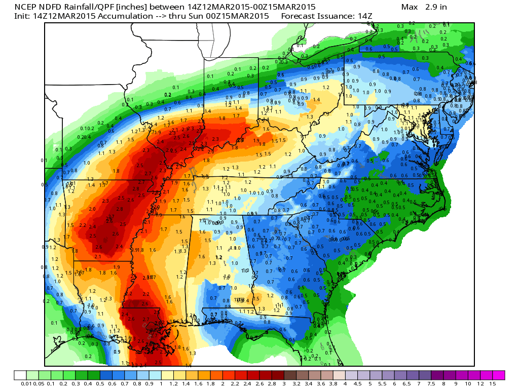
These are the official NWS gridded rainfall forecast totals. In other words, these are the totals the NWS are forecasting. Image from weatherbell.com

No winter weather! Imagine that. Winter is slipping away. One day a time…close and closer to spring we go. Light at the end of the tunnel.
Jim Rasor has a new blog. Check it out when you have time http://mylocalweather.net/forum/home

This section of the blog is speculative forecast information. Because it is past the range of what meteorologists can forecast accurately, it should be considered speculation. Anything past day 5 is considered a long range forecast.
A lot of people are talking about a snowstorm next week or the week after. Rumors flying faster than Wile. E Coyote chasing the Roadrunner. But, woah woah woah – let’s put on the brakes.

Now, if you have been following me for anytime at all then you will know that I am not a fan of these day 10 snowfall maps that people float around. This time I have not seen the maps. What I have seen are a few non-meteorologists saying (this was as of last week, as a matter of fact) that another big snowstorm would hit our region around the 20th. Then, to add to the drama, the Farmers Almanac apparently is forecasting snow around the same time.
What is the truth? Could they be right?
Well, of course they could be right. And, of course…they could be wrong. They are throwing a dart.
As I have been talking about for awhile now, we are going to see more cold weather. Winter is not finished. The question is whether or not the SNOW is finished. When you have cold air then you have at least a chance for snow.
The signals are there for a cold spell towards the middle/end of next week and lasting into at least part of the following week. But, the signals are not all that strong, yet, for a snow event in our region. Could that change? It sure could. We take a wait and see approach when forecasting snow days and days in advance. Anyone telling you that it is going to snow next week is guessing. They are seeing that it will turn cold again. They are seeing that the pattern might favor some snow somewhere in the Eastern United States, but that is it. There are no details. There can not be a real forecast that far in advance. Yes, there CAN be a forecast, but it is not going to be a reliable forecast.
We have plenty of time to monitor. I am on top of the situation. 🙂 I will continue to monitor the trends over the coming days.
How cold might this cold snap be? We are definitely not finished with the 20’s. We may not be finished with temperatures in the teens. The core of the cold weather should be towards the last part of next week.
I am thinking that April and May might bring above normal temperatures. We will see how that goes. This recurring cycle seems to not want to let cold. A lot of northwest flow. That means winds from the northwest. That means cool temperatures. If it does continue then we can expect several rounds of below normal temperatures, as well.
I am not tracking any other significant precipitation events, at this time. We get through today and tomorrow/Saturday morning then we should be somewhat dry for a spell. Hopefully that will give the rivers a chance to drain.
Watching for precipitation chances towards the middle or end of next week.
Still not seeing any signals for severe thunderstorms, either. That is certainly great news. Welcome news.
Here is what that cold shot looks like in the long range data
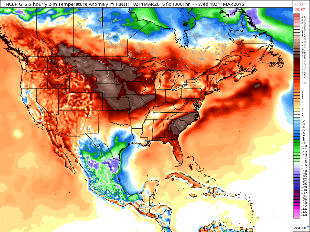
Today’s temperature anomalies. WARM for a large chunk of the U.S. – well above normal temperatures
What does temperature anomalies mean? This map tells you how much above or below normal temperatures are. In F°
Let’s look at late next week…uh oh. Blue can’t be good news. That is the beginning of a big cold blast.
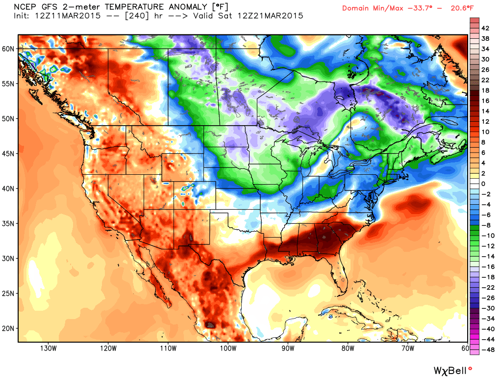
What would that look like temperature wise? Brrr – that is the cold air moving into the Missouri Valley on Friday night and Saturday morning (the 20th and 21st). I think we see low temperatures into the 20’s again before all is said and done. We can handle that. Now, whether or not we see teens again, that is the question. We shall see.
Also, keep in mind – models sometimes overplay their hand on cold temperatures this far out. Yes, it will likely be cold later next week. But how cold…we will have to watch the data.
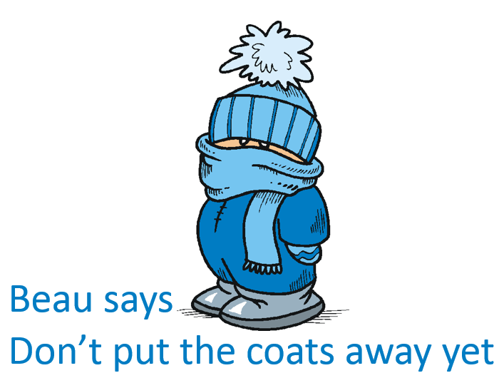
Maybe don’t be the coats away just yet.
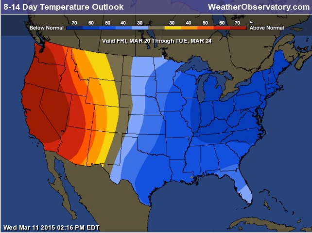
The 8-14 Day Temperature Forecast – tells the story
We have regional radars and local city radars – if a radar does not seem to be updating then try another one. Occasional browsers need their cache cleared. You may also try restarting your browser. That usually fixes the problem. Occasionally we do have a radar go down. That is why I have duplicates. Thus, if one fails then try another one.
If you have any problems then please send me an email beaudodson@usawx.com
WEATHER RADAR PAGE – Click here —
We also have a new national interactive radar – you can view that radar by clicking here.
Local interactive city radars include St Louis, Mt Vernon, Evansville, Poplar Bluff, Cape Girardeau, Marion, Paducah, Hopkinsville, Memphis, Nashville, Dyersburg, and all of eastern Kentucky – these are interactive radars. Local city radars – click here
NOTE: Occasionally you will see ground clutter on the radar (these are false echoes). Normally they show up close to the radar sites – including Paducah.
Regional Radar – Click on radar to take you our full radar page.


Regional Radar

Live Lightning Data – zoom and pan: Click here
Live Lightning Data with sound (click the sound button on the left side of the page): Click here
![]()
Current WARNINGS (a warning means take action now). Click on your county to drill down to the latest warning information. Keep in mind that there can be a 2-3 minute delay in the updated warning information.
I strongly encourage you to use a NOAA Weather Radio or warning cell phone app for the most up to date warning information. Nothing is faster than a NOAA weather radio.


Color shaded counties are under some type of watch, warning, advisory, or special weather statement. Click your county to view the latest information.

Missouri Warnings

Illinois Warnings

Kentucky Warnings

Please visit your local National Weather Service Office by clicking here. The National Weather Service Office, for our region, is located in Paducah, Kentucky. They have a lot of maps and information on their site. Local people…local forecasters who care about our region.


Here is the official 6-10 day and 8-14 day temperature and precipitation outlook. Check the date stamp at the top of each image (so you understand the time frame).
The forecast maps below are issued by the Weather Prediction Center (NOAA).


The latest 8-14 day temperature and precipitation outlook. Note the dates are at the top of the image. These maps DO NOT tell you how high or low temperatures or precipitation will be. They simply give you the probability as to whether temperatures or precipitation will be above or below normal.


Who do you trust for your weather information and who holds them accountable?
I have studied weather in our region since the late 1970’s. I have 37 years of experience in observing our regions weather patterns. My degree is in Broadcast Meteorology from Mississippi State University and an Associate of Science (AS). I am currently working on my Bachelor’s Degree in Geoscience. Just need to finish two Spanish classes!
I am a member of the American Meteorological Society. I am a NOAA Weather-Ready Nation Ambassador. And, I am the Meteorologist for McCracken County Emergency Management.
I own and operate the Southern Illinois Weather Observatory.
There is a lot of noise on the internet. A lot of weather maps are posted without explanation. Over time you should learn who to trust for your weather information.
My forecast philosophy is simple and straight forward.
- Communicate in simple terms
- To be as accurate as possible within a reasonable time frame before an event
- Interact with you on Twitter, Facebook, and the blog
- Minimize the “hype” that you might see on television or through other weather sources
- Push you towards utilizing wall-to-wall LOCAL TV coverage during severe weather events
I am a recipient of the Mark Trail Award, WPSD Six Who Make A Difference Award, Kentucky Colonel, and the Caesar J. Fiamma” Award from the American Red Cross. In 2009 I was presented with the Kentucky Office of Highway Safety Award. I was recognized by the Kentucky House of Representatives for my service to the State of Kentucky leading up to several winter storms and severe weather outbreaks.
If you click on the image below you can read the Kentucky House of Representatives Resolution.

I am also President of the Shadow Angel Foundation which serves portions of western Kentucky and southern Illinois.
Many of my graphics are from www.weatherbell.com – a great resource for weather data, model data, and more


This blog was inspired by ABC 33/40’s Alabama Weather Blog – view their blog
Current tower cam view from the Weather Observatory- Click here for all cameras.

Southern Illinois Weather Observatory

The Weather Observatory

Southern Illinois Weather Observatory
WSIL TV 3 has a number of tower cameras. Click here for their tower camera page & Illinois Road Conditions

Marion, Illinois
WPSD TV 6 has a number of tower cameras. Click here for their tower camera page & Kentucky Road Conditions & Kentucky Highway and Interstate Cameras

Downtown Paducah, Kentucky
Benton, Kentucky Tower Camera – Click here for full view

Benton, Kentucky

I24 Paducah, Kentucky

I24 Mile Point 9 – Paducah, KY

I24 – Mile Point 3 Paducah, Kentucky

You can sign up for my AWARE email by clicking here I typically send out AWARE emails before severe weather, winter storms, or other active weather situations. I do not email watches or warnings. The emails are a basic “heads up” concerning incoming weather conditions.