We have some great sponsors for the Weather Talk Blog. Please let our sponsors know that you appreciate their support for the Weather Talk Blog.
Milner and Orr Funeral Home and Cremation Services located in Paducah, Kentucky and three other western Kentucky towns – at Milner and Orr they believe in families helping families. You can find Milner and Orr on Facebook, as well.
![]()
.

For all of your families eye care needs. Visit their web-site here. Or, you can also visit their Facebook page.
.

Endrizzi’s Storm Shelters – For more information click here. Endrizzi Contracting and Landscaping can be found on Facebook, as well – click here
.

Best at Enabling Body Shop Profitability since 1996. Located In Paducah Kentucky and Evansville Indiana; serving all customers in between. They provide Customer Service, along with all the tools necessary for body shops to remain educated and competitive. Click the logo above for their main web-site. You can find McClintock Preferred Finishes on Facebook, as well
.

Duck/goose decoys? Game calls? Optics? We have you covered! Click the logo above or visit Final Flight on Facebook, as well.
.
.
I have launched the new weather texting service! I could use your help. Be sure and sign up and fully support all of the weather data you see each day.
This is a monthly subscription service. Supporting this helps support everything else. The cost is $3 a month for one phone, $5 a month for three phones, and $10 a month for seven phones.
For more information visit BeauDodsonWeather.com
Or directly sign up at Weathertalk.com


This forecast update covers far southern Illinois, far southeast Missouri, and far western Kentucky. See the coverage map on the right side of the blog.
Remember that weather evolves. Check back frequently for updates, especially during active weather.
Click Here For River Stage Forecasts…
Avoid flooded roadways!

This is a complex forecast and the forecast will vary GREATLY across our region. It is possible that we have 50 degrees in west KY with thunderstorms on Saturday and then 30s over parts of southeast Missouri with snow. Tricky forecast.
Friday night – An increasing chance for showers after midnight.
Temperatures: Lows are going to vary across the area. 40s are likely over northern parts of southeast Missouri and southern Illinois. Upper 40s to lower 50s possible over the rest of southeast Missouri, southern Illinois, western Kentucky, and northwest Tennessee.
Winds: South winds at 6-12 mph. Winds may turn towards the northwest over our far northwest counties of the area.
What is the chance for precipitation? 20% before midnight. Increasing to 60% by Saturday morning.
Coverage of precipitation? Scattered
My confidence in this part of the forecast verifying is Medium
Should I be concerned about snow or ice? No
Should I cancel my outdoor plans? No
Is severe weather expected? No
What impact is expected? Wet roadways. Rivers and streams will continue to run high. Avoid flooded roadways.
There are some guidance packages that show 1-2″ of snow possible over the rest of the area on Saturday evening and night. The chances are small. But, not zero. I would say about 30%-40% chance of that happening. Keep this in mind. There remain some questions about this system and the eventual outcome of snow over our area.
Saturday – Cloudy. Rain overspreading the region. A few downpours possible. Maybe a rumble of thunder over southeast Illinois, western Kentucky and northwest Tennessee. Rain may change or mix with snow over parts of southeast Missouri and southern Illinois. Most likely this would occur from near Winona, Missouri towards Mt Vernon, Illinois. North and west of that line. Can’t rule out accumulating snow in those areas. If you have travel plans to the north and west on Saturday then monitor updated information.
Temperatures: Highs in the upper 40s to lower 50s. Temperatures will fall behind the cold front. Wide range of temperatures on Saturday. Expect 30s for our far northwest counties. Butler County, Missouri towards Ste Genevieve County, Missouri towards Mt Vernon, Illinois. If the low tracks as expected then temperatures will fall into the 30s in those areas. Any change in the track of the low will change the forecast conditions for our area. Keep this in mind.
Winds: Southeast winds at 10-20 mph ahead of the cold front. Winds will switch to the west/northwest behind the cold front at speeds of 10-25 mph with gusts above 30 mph.
What is the chance for precipitation? 100%
Coverage of precipitation? Widespread
My confidence in this part of the forecast verifying is Medium
Should I be concerned about snow or ice? Snow will be possible over our west and northwest counties of southeast Missouri and southern Illinois. That would include Ripley County, Missouri and then northeast from there into Perry County, Missouri and then into Jefferson County, Illinois. Along that line and west/north of that line stands the best chance for accumulating snow. ANY shift in this storm will change the placement of snow. We are talking about a few counties difference between rain and snow. Tricky forecast.
Should I cancel my outdoor plans? Rain likely. Have a plan B.
Is severe weather expected? No, but lightning is possible over western Kentucky and northwest Tennessee. Very small risk for strong storms over western Tennessee and near the Kentucky and Tennessee border. Gusty winds the main concern.
What impact is expected? Wet roadways. Maybe some lightning. Rivers and streams will continue to run high. Avoid flooded roadways. There will be a chance for some slick roads developing during Saturday afternoon and evening over our far northwest counties. Ripley County, Missouri towards Perry/Ste Genevieve County, MO towards perhaps Mt Vernon. Further west/northwest you travel the better odds of experiencing some slushy/wet snow. And, eventually the slushy snow would move into central Illinois. See maps in the discussion part of the blog.
Saturday night – A chance for showers changing to snow showers. A brief period of sleet possible. Turning colder from northwest to southeast. Patchy light freezing drizzle also possible over western Kentucky. Perhaps a dusting or so of snow for some areas. More over far western counties and northwest counties in southeast Missouri and southern Illinois. Black ice is possible. That means moisture on roadways freeze.
Temperatures: Lows in the 25 to 35 degree range. Temperatures may vary a bit on Saturday night as a cold front moves through the area.
Winds: Northwest winds at 10-30 mph. Winds may be gusty.
What is the chance for precipitation? 80% before midnight and then 60% after midnight.
Coverage of precipitation? Scattered to widespread.
My confidence in this part of the forecast verifying is Medium
Should I be concerned about snow or ice? Rain should change to snow or wintry mix before ending.
Should I cancel my outdoor plans? Colder temperatures and some precipitation possible.
Is severe weather expected? No
What impact is expected? If the cold air moves in quick enough then there could be a few slick spots if a little moisture remains on roadways.
Sunday – Mix of sun and clouds. Can’t rule out a morning flurry or light freezing drizzle. Cold. Windy at times. Wind chills could dip into the single digits to teens.
Temperatures: Highs in the upper 20s to middle 30s. Temperatures may not rise much on Sunday. Steady or even falling temperatures.
Winds: Northwest wind 10-20 mph. Higher gusts possible.
What is the chance for precipitation? 30% before 9 am.
Coverage of precipitation? Isolated early in the day. Mainly our eastern counties of western Kentucky.
My confidence in this part of the forecast verifying is Medium
Should I be concerned about snow or ice? Small chance for a brief period of a wintry mix before 9 am on Sunday.
Should I cancel my outdoor plans? It will be turning quite cold on Sunday with low wind chills possible.
Is severe weather expected? No
What impact is expected? If the cold air moves in quick enough then there could be a few slick spots if a little moisture remains on roadways. Low wind chills and cold temperatures.
Sunday night – Clearing. Breezy early. Bitterly cold.
Temperatures: Lows from 14 to 20 degrees across most of the area. Perhaps lower 20s near the KY/TN border.
Winds: Northwest winds at 8-16 mph dying down to 4-8 mph late.
What is the chance for precipitation? 10%
Coverage of precipitation? None
My confidence in this part of the forecast verifying is Medium
Should I be concerned about snow or ice? No
Should I cancel my outdoor plans? No, but it will be cold.
Is severe weather expected? No
What impact is expected? Cold temperatures into the teens. Low wind chills into the single digits.
Monday – Mostly sunny. Perhaps a few clouds. Cold.
Temperatures: Highs will range from the upper 20s to middle 30s. Below normal temperatures. Chilly start to the day, as well.
Winds: Northwest winds becoming southwest winds at 5-10 mph.
What is the chance for precipitation? 0%
Coverage of precipitation? None
My confidence in this part of the forecast verifying is High
Should I be concerned about snow or ice? No
Should I cancel my outdoor plans? It will be cold!
Is severe weather expected? No
What impact is expected? Cold temperatures.


Don’t forget to check out the Southern Illinois Weather Observatory web-site for weather maps, tower cams, scanner feeds, radars, and much more! Click here

An explanation of what is happening in the atmosphere over the coming days…
Highlights
1. Focus of this update will be the Saturday rain/snow system (mostly rain for my forecast counties)
2. Much colder air arrives Saturday night into Sunday
3. Chilly start to the new work week
Today is a travel day for me! Updating on the train. Forgive any spelling errors. 🙂
WEATHER RADAR PAGE – Click here —
Complicated forecast over the next 48 hours. And, the weather will vary GREATLY across our region. Keep this in mind.
There are some guidance packages that show 1-2″ of snow possible over the rest of the area on Saturday evening and night. The chances are small. But, not zero. I would say about 30%-40% chance of that happening. Keep this in mind. There remain some questions about this system and the eventual outcome of snow over our area.
The big topic seems to be our weekend winter storm. I have been asked several dozen times how much snow we can expect! I guess word spreads fast when the S word is used. And, I have seen some maps floating around with accumulation totals on them. I like to wait until 24 hours out for snowfall forecast maps. Maps don’t verify, most of the time, more than one day out. At least specific amounts.
The track of the surface low and 850 mb low is key to what happens in our region. If you read my updates then you will know that the snow usually occurs west and north of the surface low (see yesterdays post with graphic examples). And, snow usually occurs 50-75 miles west/northwest of the 850 mb low.
The surface low and 850 mb low are currently forecast to pass right over our area. That means this is mostly a rain event for southern Illinois, western Kentucky, northwest Tennessee, and far southeast Missouri. The rain would likely end as a brief period of snow and perhaps a wintry mix (some sleet/freezing drizzle briefly). This would occur as colder air filters into the region as the low pulls away to our northeast.
A period of moderate or even heavy snow is possible across parts of south central Missouri into the St Louis, Missouri area and then east/northeast from there. Perhaps a few inches of wet snow late Saturday afternoon and evening. This would happen as the area of low pressure deepens and the 850 mb low tightens up. Basically that would help tap into colder air on the west/northwest side of the low pressure centers.
If you want heavy snow over southern Illinois and western Kentucky then you want to see the 850 mb low pass through northern Mississippi and into Tennessee. Currently the 850 mb low is forecast to pass right over southeast Missouri, southern Illinois, and western Kentucky. Not a good track for accumulating snow. At least for most of us.
These type of systems can sometimes offer up surprises. Winter storms are tricky, at best, to forecast on any given day. I don’t believe far southeast Missouri, most of southern Illinois, western Kentucky, and northwest Tennessee will experience accumulating snow from this system. Yes, there could be a quick dusting in a few spots. But, the heavier snow is forecast to be just barely outside my forecast county zones.
Black ice is possible on Saturday night and Sunday morning. What is black ice? Black ice is simply ice that forms on roadways when temperatures quickly fall after a rain event. Moisture can freeze and cause slick spots. This can happen fairly quickly. Road temperatures are semi-warm. That might help us out. But, if temperatures fall into the 20s then roads could freeze. Bridges and overpasses would freeze first.
As always, the forecast can change. Especially true in the winter. If the system were to shift just a little south and east then I would need to adjust my thinking. Keep that in mind. Forecasts are always fluid.
Colder air will sweep into the area behind this system. High temperatures on Sunday may not get out of the 30s. Low temperatures on Sunday night and Monday morning will dip into the teens. Brrrr weather.
The cold weather should stick around into the new work week. And, there are signals for another big dump of cold air next week (18th-22nd). Long way off to comment on that event. But, I am monitoring.
The pattern is active. Those wanting snow should not give up. Remember, last year most of our snow was in February and March. And, that is the forecast again this year. If we were to have significant snow or ice then I have been thinking February and March.
Not saying we can’t have a snowstorm here in January. There are definitely signals for several more systems to track over the next 15-20 days. Or, the rest of January.
For those not wanting snow, well enjoy this weather.
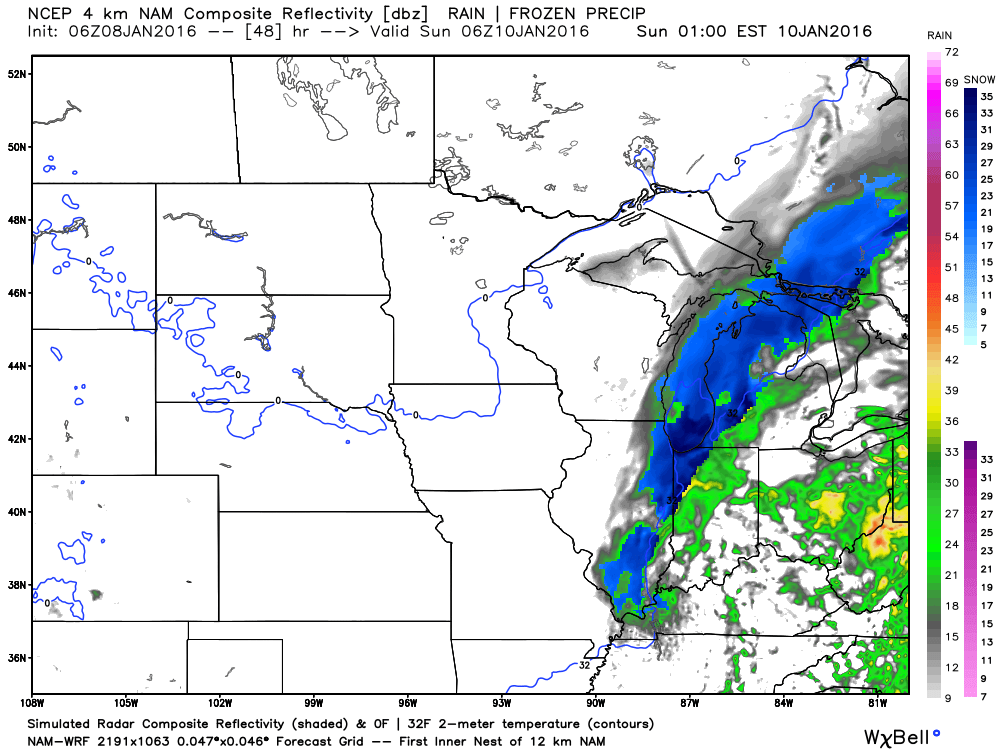
Let’s look at some maps.
These maps are from weatherbell.com
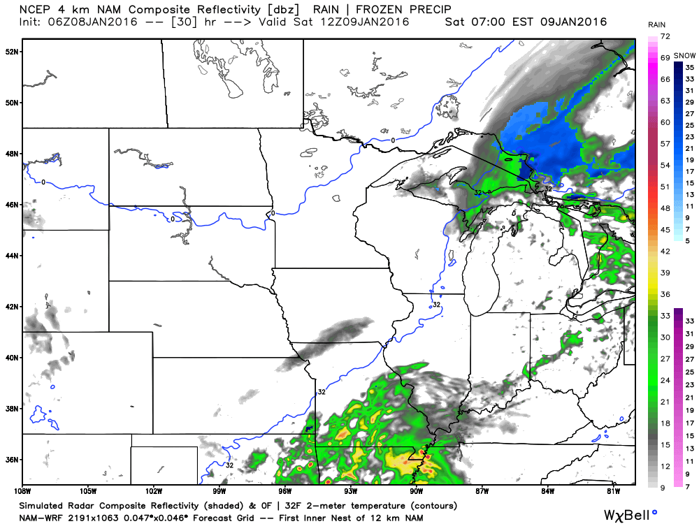
These maps are future-cast radar. What is that? That is what the radar MIGHT look like with this system. This is one models idea of how this will play out. And, I agree with it. Blue is snow. Green is rain. Click images to enlarge.
This first image is for 6 am on Saturday morning. Rain is spreading in from the southwest. The rain is moving northeast. Saturday will deliver a period of widespread rain to our area. Some thunder possible.
This next image is for Saturday at 11 am. Notice the dark blue over Missouri? That is the developing snow as cold air is pulled into this system.
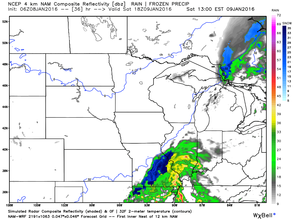
This next image is for 6 pm on Saturday evening. Notice the sharp cut off from snow to rain. VERY close call for our area on snowfall.
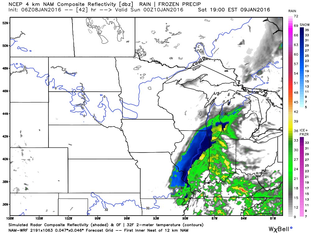
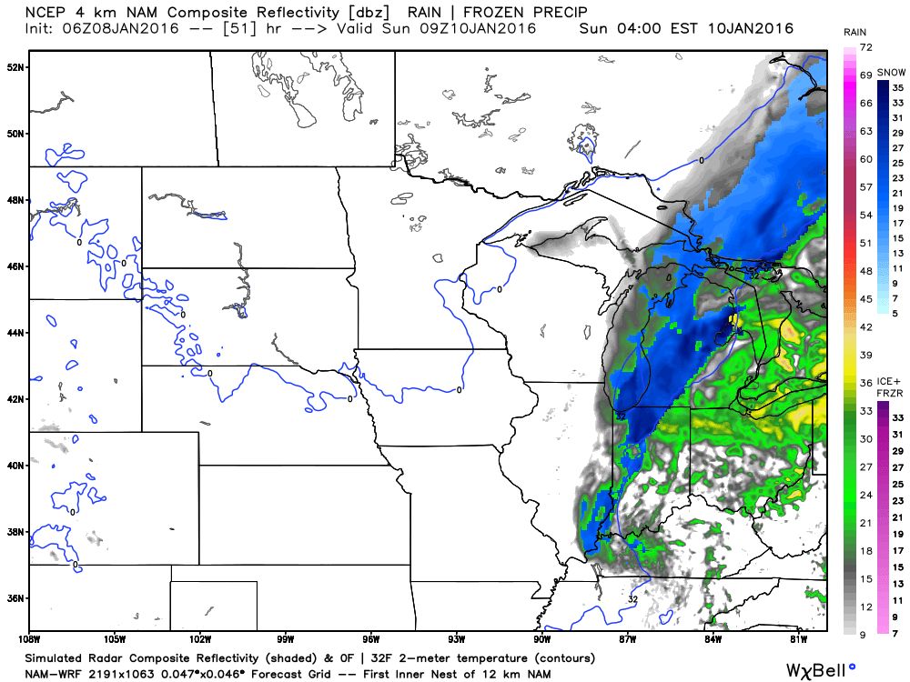
This next image is for Saturday evening around 9 pm. Give or take. Colder air is pushing into our area. Rain will change to snow showers. Maybe a brief period of sleet.
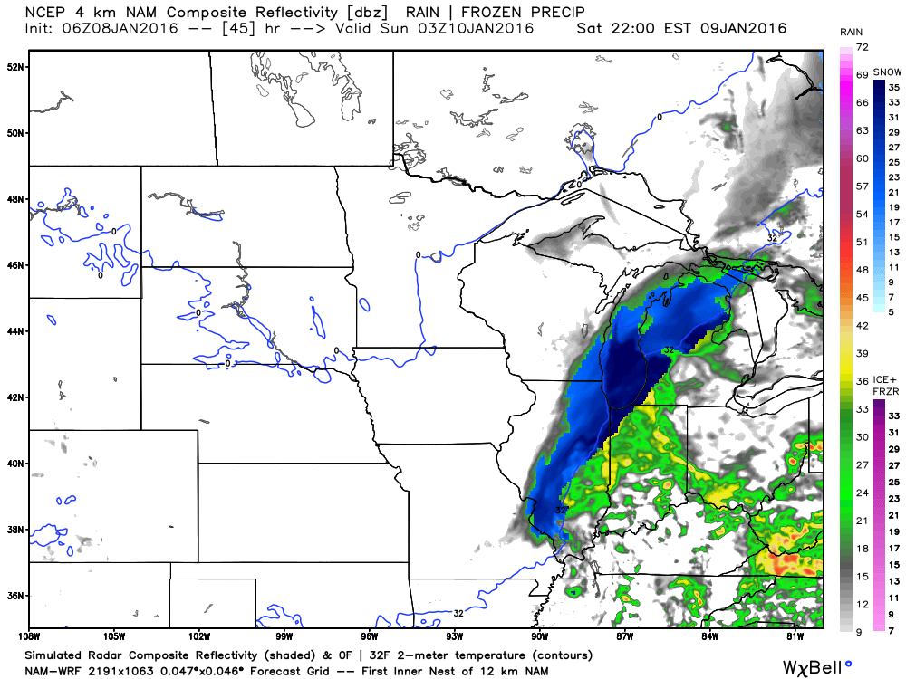
This next image is for 11 pm on Saturday night. Give or take an hour. You can see snow showers over our area. Just how much moisture is left once the cold air arrives. That is the question. Can someone pick up a dusting or an inch of snow? Yes, it is possible.
This next image is for 3 am on Sunday morning. Precipitation is moving out. Blue is snow.
It will be windy on Saturday and Sunday. Winds could gust above 30 mph from time to time. As the area of low pressure deepens the isobars will tighter up. Isobars are equal lines of pressure. The closer they are packed together the strong winds can become at the surface.
Here is the NAM model guidance depiction of the surface low on Saturday afternoon. You can see the low moving over our local area. The light blue lines represent equal lines of pressure. Isobars.
Click image to enlarge it.

As the low moves overhead, on Saturday afternoon and evening, the winds will die down. But, for those on the west and northwest side of the low, you can expect strong and gusty winds. That would like be in areas where colder air is arriving and rain is changing to snow.
Here are some forecast wind speed gusts for Saturday and Sunday. Time stamp top right.
This first image is for Saturday around 11 am. Click image for a larger view. The numbers represent wind gusts.

This next image is for Saturday afternoon around 5 pm. You can see some gusts above 30 mph over southwest Illinois back into southeast Missouri.

This next image is for 11 pm on Saturday night. Gusty winds! Some gusts are approaching 40 mph over Illinois. Expect a lot of 20-30 mph wind gusts.

This next image is for 5 am on Sunday morning. Still some 20-30 mph wind gusts, at that time.

Clickable watch and warning map


Here are the current river stage forecasts. You can click your state and then the dot for your location. It will bring up the full forecast and hydrograph.
Click Here For River Stage Forecasts…

See discussion below.

Friday – No snow or ice anticipated.
Saturday – Snow is possible over our northwest counties on Saturday. That would include areas like Ste Genevieve County, Missouri and perhaps Perry County, Missouri the north and northeast from there. Also west and northwest from there. A period of light snow will be possible across our entire area on Saturday afternoon (late) and Saturday night. Small chance for a wintry mix on Sunday morning over western Kentucky, as well. Main concern will be any moisture left on roadways. This moisture could freeze as temperatures fall into the twenties Saturday night.
Sunday – Small chance for patchy light snow or freezing drizzle over western Kentucky. Small chance. Also, there could be patchy slick spots on roads Sunday morning. Part of this will depend on whether light snow falls on Saturday night. And, if moisture is left on roadways from Saturday’s rain.
Monday/Tuesday – At this time no snow or ice is expected on Monday. Another weak system will approach our region on Monday/Tuesday. I suppose I can’t completely rule out snow flurries.

Updated rain and snow probabilities for the weekend. Also mentioned patchy ice on roadways as temperatures fall into the 20s.

Some accumulating snow is possible on Saturday and Saturday night, especially over parts of southeast Missouri and southwest Illinois. The further north and west you travel the more likely snow could accumulate. Believe most of my forecast counties won’t experience much in the way of snow accumulation. Perhaps Ste Genevieve County, Missouri towards Jefferson County, Illinois. Low confidence on sticking snow.
Patchy ice is possible on roadways Saturday night and Sunday morning. Falling temperatures could freeze any moisture left on roadways.

Avoid flooded roadways. Rivers remain high.
Monitor updated forecasts concerning the potential of snow on Saturday and Saturday night over our northwest counties.
I am also a concerned about black ice. Black ice forms as cold air moves into an area where rain has recently fallen. Wet pavements can freeze if the cold air moves in fast enough. That is a possibility on Saturday and Saturday night. If you have travel plans on Saturday/Saturday night then you will want to monitor updated forecasts.

Two wild cards in this update
Some thunder possible on Saturday over western Kentucky and western Tennessee. Severe weather risk appears minimal.
SNOW? Will our northwest counties pick up a dusting or so of snow? It does appear possible. A band of accumulating snow is likely to occur to the northwest of the area of low pressure. That could include some of our southeast Missouri counties and southwest Illinois counties. Monitor updates

How much precipitation should we expect over the next few days?
Expect this system to produce 0.40″ to 0.80″ of rain. A general rain is expected. Our Thursday system did not produce as much rain for some of you. I messed that part of the forecast up. About half the area received what I forecast. The other half did not.
This next event on Saturday should verify.

Can we expect severe thunderstorms over the next 24 to 48 hours? Remember that a severe thunderstorm is defined as a thunderstorm that produces 58 mph winds or higher, quarter size hail or larger, and/or a tornado.
The thunderstorm threat level will be a ONE on Saturday. I am now monitoring Saturday for possible thunderstorms. Believe any severe weather risk would be well to our south. But, perhaps some of our counties could experience lightning/thunder.
I am monitoring Saturday for possible storms in the region. This will be determined by the track of the area of low pressure. Not expecting severe weather. But, lightning will be possible.

Here are the current river stage forecasts. You can click your state and then the dot for your location. It will bring up the full forecast and hydrograph.
Click Here For River Stage Forecasts…
Here are some current forecast hydrographs. These will be updated each day with new information.


Smithland Lock and Dam

Paducah, Kentucky Forecast Stage

Cairo, Illinois

Cape Girardeau, Missouri

We have regional radars and local city radars – if a radar does not seem to be updating then try another one. Occasional browsers need their cache cleared. You may also try restarting your browser. That usually fixes the problem. Occasionally we do have a radar go down. That is why I have duplicates. Thus, if one fails then try another one.
If you have any problems then please send me an email beaudodson@usawx.com
WEATHER RADAR PAGE – Click here —
We also have a new national interactive radar – you can view that radar by clicking here.
Local interactive city radars include St Louis, Mt Vernon, Evansville, Poplar Bluff, Cape Girardeau, Marion, Paducah, Hopkinsville, Memphis, Nashville, Dyersburg, and all of eastern Kentucky – these are interactive radars. Local city radars – click here
NOTE: Occasionally you will see ground clutter on the radar (these are false echoes). Normally they show up close to the radar sites – including Paducah.


Here is the official 6-10 day and 8-14 day temperature and precipitation outlook. Check the date stamp at the top of each image (so you understand the time frame).
The forecast maps below are issued by the Weather Prediction Center (NOAA).


The latest 8-14 day temperature and precipitation outlook. Note the dates are at the top of the image. These maps DO NOT tell you how high or low temperatures or precipitation will be. They simply give you the probability as to whether temperatures or precipitation will be above or below normal.


Here are the current river stage forecasts. You can click your state and then the dot for your location. It will bring up the full forecast and hydrograph.
Click Here For River Stage Forecasts…

Who do you trust for your weather information and who holds them accountable?
I have studied weather in our region since the late 1970’s. I have 37 years of experience in observing our regions weather patterns. My degree is in Broadcast Meteorology from Mississippi State University and an Associate of Science (AS). I am currently working on my Bachelor’s Degree in Geoscience.
My resume includes:
Member of the American Meteorological Society.
NOAA Weather-Ready Nation Ambassador.
Meteorologist for McCracken County Emergency Management. I served from 2005 through 2015.
I own and operate the Southern Illinois Weather Observatory.
Recipient of the Mark Trail Award, WPSD Six Who Make A Difference Award, Kentucky Colonel, and the Caesar J. Fiamma” Award from the American Red Cross.
In 2009 I was presented with the Kentucky Office of Highway Safety Award.
Recognized by the Kentucky House of Representatives for my service to the State of Kentucky leading up to several winter storms and severe weather outbreaks.
I am also President of the Shadow Angel Foundation which serves portions of western Kentucky and southern Illinois.
There is a lot of noise on the internet. A lot of weather maps are posted without explanation. Over time you should learn who to trust for your weather information.
My forecast philosophy is simple and straight forward.
- Communicate in simple terms
- To be as accurate as possible within a reasonable time frame before an event
- Interact with you on Twitter, Facebook, and the blog
- Minimize the “hype” that you might see on television or through other weather sources
- Push you towards utilizing wall-to-wall LOCAL TV coverage during severe weather events
I am a recipient of the Mark Trail Award, WPSD Six Who Make A Difference Award, Kentucky Colonel, and the Caesar J. Fiamma” Award from the American Red Cross. In 2009 I was presented with the Kentucky Office of Highway Safety Award. I was recognized by the Kentucky House of Representatives for my service to the State of Kentucky leading up to several winter storms and severe weather outbreaks.
If you click on the image below you can read the Kentucky House of Representatives Resolution.

Many of my graphics are from www.weatherbell.com – a great resource for weather data, model data, and more


You can sign up for my AWARE email by clicking here I typically send out AWARE emails before severe weather, winter storms, or other active weather situations. I do not email watches or warnings. The emails are a basic “heads up” concerning incoming weather conditions.