We have some great sponsors for the Weather Talk Blog. Please let our sponsors know that you appreciate their support for the Weather Talk Blog.
Milner and Orr Funeral Home and Cremation Services located in Paducah, Kentucky and three other western Kentucky towns – at Milner and Orr they believe in families helping families. You can find Milner and Orr on Facebook, as well.
![]()
.

Wortham Dental Care located in Paducah, Kentucky. The gentle dentist. Mercury free dentistry. They also do safe Mercury removal. You can find Wortham Dental Care on Facebook, as well
.

For all of your families eye care needs. Visit their web-site here. Or, you can also visit their Facebook page.
.

Endrizzi’s Storm Shelters – For more information click here. Endrizzi Contracting and Landscaping can be found on Facebook, as well – click here
.

Best at Enabling Body Shop Profitability since 1996. Located In Paducah Kentucky and Evansville Indiana; serving all customers in between. They provide Customer Service, along with all the tools necessary for body shops to remain educated and competitive. Click the logo above for their main web-site. You can find McClintock Preferred Finishes on Facebook, as well
.

Duck/goose decoys? Game calls? Optics? We have you covered! Click the logo above or visit Final Flight on Facebook, as well.
.
.
I have launched the new weather texting service! I could use your help. Be sure and sign up and fully support all of the weather data you see each day.
This is a monthly subscription service. Supporting this helps support everything else. The cost is $3 a month for one phone, $5 a month for three phones, and $10 a month for seven phones.
For more information visit BeauDodsonWeather.com
Or directly sign up at Weathertalk.com


This forecast update covers far southern Illinois, far southeast Missouri, and far western Kentucky. See the coverage map on the right side of the blog.
Remember that weather evolves. Check back frequently for updates, especially during active weather.
Click Here For River Stage Forecasts…
Avoid flooded roadways!

Thursday night – A period of showers possible. Showers ending late.
Temperatures: Lows in the 40-45 degree range
Winds: Southeast winds at 7-14 mph
What is the chance for precipitation? 70% early and then 30% after midnight.
Coverage of precipitation? A period of widespread showers decreasing as night wears on.
My confidence in this part of the forecast verifying is High
Should I be concerned about snow or ice? No
Should I cancel my outdoor plans? Yes, have a plan B
Is severe weather expected? No
What impact is expected? Wet roadways. Rivers and streams will continue to run high. Avoid flooded roadways.
Friday – Mostly cloudy with a chance for a few breaks on the clouds. Small chance for a shower before 5 am. Mild for January.
Temperatures: Highs in the 52-56 degree range. Can’t rule out 60 degrees over the Missouri Bootheel and NW Tennessee.
Winds: South/southwest winds at 7-14 mph with gusts to 20 mph.
What is the chance for precipitation? 30% early in the morning (mainly before 5 am)
Coverage of precipitation? Scattered early in the day (before 5 am)
My confidence in this part of the forecast verifying is Medium
Should I be concerned about snow or ice? No
Should I cancel my outdoor plans? No
Is severe weather expected? No
What impact is expected? Wet roadways. Rivers and streams will continue to run high. Avoid flooded roadways.
Friday night – An increasing chance for showers after midnight.
Temperatures: Lows are going to vary across the area. 40s are likely over northern parts of southeast Missouri and southern Illinois. Upper 40s to lower 50s possible over the rest of southeast Missouri, southern Illinois, western Kentucky, and northwest Tennessee.
Winds: South winds at 6-12 mph. Winds may turn towards the northwest over our far northwest counties of the area.
What is the chance for precipitation? 20% before midnight. Increasing to 60% by Saturday morning.
Coverage of precipitation? Scattered
My confidence in this part of the forecast verifying is Medium
Should I be concerned about snow or ice? No
Should I cancel my outdoor plans? No
Is severe weather expected? No
What impact is expected? Wet roadways. Rivers and streams will continue to run high. Avoid flooded roadways.
Saturday – Cloudy. A good chance for rain. Maybe a rumble of thunder over southeast Illinois, western Kentucky and northwest Tennessee. Rain may change or mix with snow over parts of southeast Missouri and southern Illinois. Most likely this would occur from near Winona, Missouri towards Mt Vernon, Illinois. North and west of that line. Can’t rule out accumulating snow in those areas. If you have travel plans to the north and west on Saturday then monitor updated information.
Temperatures: Highs in the upper 40s to lower 50s. Temperatures will fall behind the cold front. Wide range of temperatures on Saturday. Expect 30s for our far northwest counties. Ste Genevieve County, Missouri towards Mt Vernon, Illinois. If the low tracks as expected then temperatures will fall into the 30s in those areas. Any change in the track of the low will change the forecast conditions for our area. Keep this in mind.
Winds: Southeast winds at 10-20 mph ahead of the cold front. Winds will switch to the west/northwest behind the cold front at speeds of 10-25 mph with gusts above 30 mph.
What is the chance for precipitation? 100%
Coverage of precipitation? Widespread
My confidence in this part of the forecast verifying is Medium
Should I be concerned about snow or ice? Snow will be possible over our west and northwest counties of southeast Missouri and southern Illinois. That would include Ripley County, Missouri and then northeast from there into Perry County, Missouri and then into Jefferson County, Illinois. Along that line and west/north of that line stands the best chance for accumulating snow.
Should I cancel my outdoor plans? Rain likely. Have a plan B.
Is severe weather expected? No, but lightning is possible over western Kentucky and northwest Tennessee.
What impact is expected? Wet roadways possible. Maybe some lightning. Rivers and streams will continue to run high. Avoid flooded roadways. There will be a chance for some slick roads developing during Saturday afternoon and evening over our far northwest counties. Ripley County, Missouri towards Perry/Ste Genevieve County, MO towards perhaps Mt Vernon. Further west/northwest you travel the better odds of experiencing some slushy/wet snow. And, eventually the slushy snow would move into central Illinois. See maps in the discussion part of the blog.
Saturday night – A chance for showers or snow showers. Turning colder from northwest to southeast. Patchy light freezing drizzle also possible over western Kentucky. Perhaps a dusting or so of snow for some areas. More over far western counties and northwest counties in southeast Missouri and southern Illinois.
Temperatures: Lows in the 30 to 36 degree range. Temperatures may vary a bit on Saturday night as a cold front moves through the area.
Winds: Northwest winds at 10-30 mph. Winds may be gusty.
What is the chance for precipitation? 80% before midnight and then 60% after midnight.
Coverage of precipitation? Scattered to widespread.
My confidence in this part of the forecast verifying is Medium
Should I be concerned about snow or ice? Rain should change to snow or wintry mix before ending.
Should I cancel my outdoor plans? Colder temperatures and some precipitation possible.
Is severe weather expected? No
What impact is expected? If the cold air moves in quick enough then there could be a few slick spots if a little moisture remains on roadways.
Sunday – Mix of sun and clouds. Can’t rule out a flurry. Cold. Windy at times.
Temperatures: Highs in the upper 20s to middle 30s. Temperatures may not rise much on Sunday. Steady or even falling temperatures.
Winds: Northwest wind 10-20 mph. Higher gusts possible.
What is the chance for precipitation? 30% before 9 am.
Coverage of precipitation? Isolated
My confidence in this part of the forecast verifying is Medium
Should I be concerned about snow or ice? Small chance for a brief period of a wintry mix before 9 am.
Should I cancel my outdoor plans? It will be turning quite cold on Sunday with low wind chills possible.
Is severe weather expected? No
What impact is expected? If the cold air moves in quick enough then there could be a few slick spots if a little moisture remains on roadways.


Don’t forget to check out the Southern Illinois Weather Observatory web-site for weather maps, tower cams, scanner feeds, radars, and much more! Click here

An explanation of what is happening in the atmosphere over the coming days…
Highlights
1. Focus of this update will be the Saturday rain/snow system (mostly rain for my forecast counties)
2. Much colder air arrives Saturday night into Sunday
3. Chilly start to the new work week
Rain showers will be with us on Thursday evening, but will be winding down from west to east as the evening/night wears on. Here is the interactive radar link
WEATHER RADAR PAGE – Click here —
Friday into Saturday night:
Our next system will begin to impact the area as early as Friday. A developing area of low pressure to our west will help push mild air into our local area. As a matter of fact, some areas could touch 60 degrees on Friday afternoon. How is that for January temperatures! Got to love our regions weather. Roller coaster. But, this isn’t going to last. Much colder air will filter into the region on Saturday into Sunday.
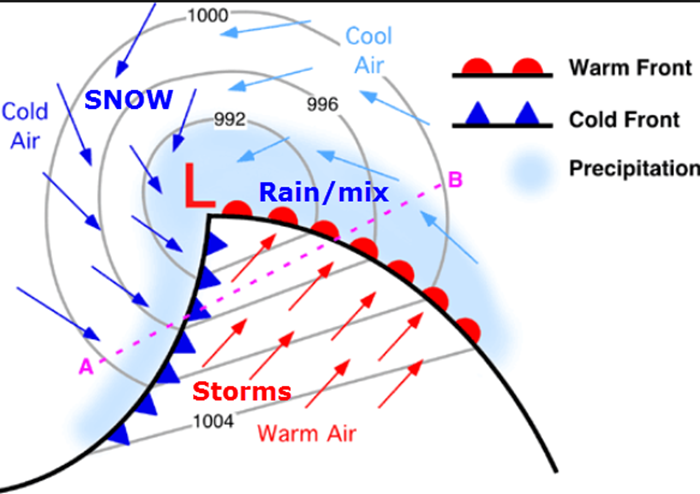
An area of low pressure is currently forecast to track through Arkansas and then move northeast into our local area on Saturday. At this time it appears the track would mean mostly rain for our region. Then, as the low pulls away, colder air will be drawn south and east. Remember, an area of low pressure rotates counter-clockwise. You have warm air pulled northward ahead of the low. You have colder air pulled south and east behind the low.
I showed you an example of this on the last blog post. I will post it again today.
Here is an example of what an area of low pressure would look like on a weather map. See the warm air? And, the cold air?
For this event, it appears there could be a few rumbles of thunder over western Kentucky and western Tennessee. No severe storms are anticipated.
Widespread rain will push through our region beginning late Friday night and ramping up on Saturday morning. Rain could be moderate at times. Colder air will rapidly push into our region behind the low. This could change the rain over to a period of light snow showers. Heavier bursts of snow are possible across parts of central and eastern Missouri into central Illinois. It is possible this band of snow will clip some of our local counties.
Now, keep in mind, the exact track of the area of low pressure is always going to be key to where the rain and snow line is drawn. For this event it appears the low will track pretty much right over our area. That keeps us mostly in the warm sector. And, the 850 mb low (a low higher up in the atmosphere) passes over our northern counties in southeast Missouri and southern Illinois. If you want snow then you want to be north and west of the 850 mb low.
Speaking of the 850 mb low. Let me show you that. There has been a trend to take this a bit further south and east. This will need to be monitored. If you want snow then you want to be on the west/northwest side of the 850 mb low. Typically about 1.5 degrees north and west of the low.
Here is the 850 mb chart. 850 mb is about 5000 feet aloft.

Now, that above is the NAM model. Let me show you the GFS model and how it tracks the low. They are both pretty close as far as agreement.

Ste Genevieve County, Missouri towards Randolph County, Illinois and perhaps Jefferson County, Illinois could see the rain change to snow on Saturday afternoon. I can’t rule out some light accumulations in those areas.
Then, as colder air filters into the rest of our area, we could experience a period of snow showers, flurries, or even patchy freezing drizzle. At this time, little to no accumulation is anticipated. Little to none would mean a dusting or less.
I will post some maps below to show you how this system should evolve.
A couple of concerns
If the cold air moves in faster than anticipated then some black ice would be possible on areas roadways. Black ice occurs when moisture is left on roadways from a recent rain event. Rain is expected on Saturday. Colder air moves in and some of that moisture remaining on the roads could freeze on Saturday night and early Sunday morning. Not sure how much of an impact this will have, but should be monitored. Warm temperatures on Friday should mean road temperatures will start out fairly warm. Also, gusty winds could help dry the roads off.
Bottom line: Some patchy slick roads could occur on Saturday night and Sunday morning in our area. But, confidence is rather low on this part of the forecast. I just wanted to mention it.
Colder air will be with us into next week. Highs on Sunday will remain in the 30s. Temperatures may actually fall during the day on Sunday. Teens are likely Sunday night and Monday morning.
Let’s look at some model guidance maps from weatherbell.com
Click images to enlarge
What you are viewing here are model guidance maps. There are many models that I could show you. I chose the NAM model. It does pretty good in the short range.
Remember, these maps are for guidance. They help make a forecast, but they don’t make a forecast. They are used for guidance.
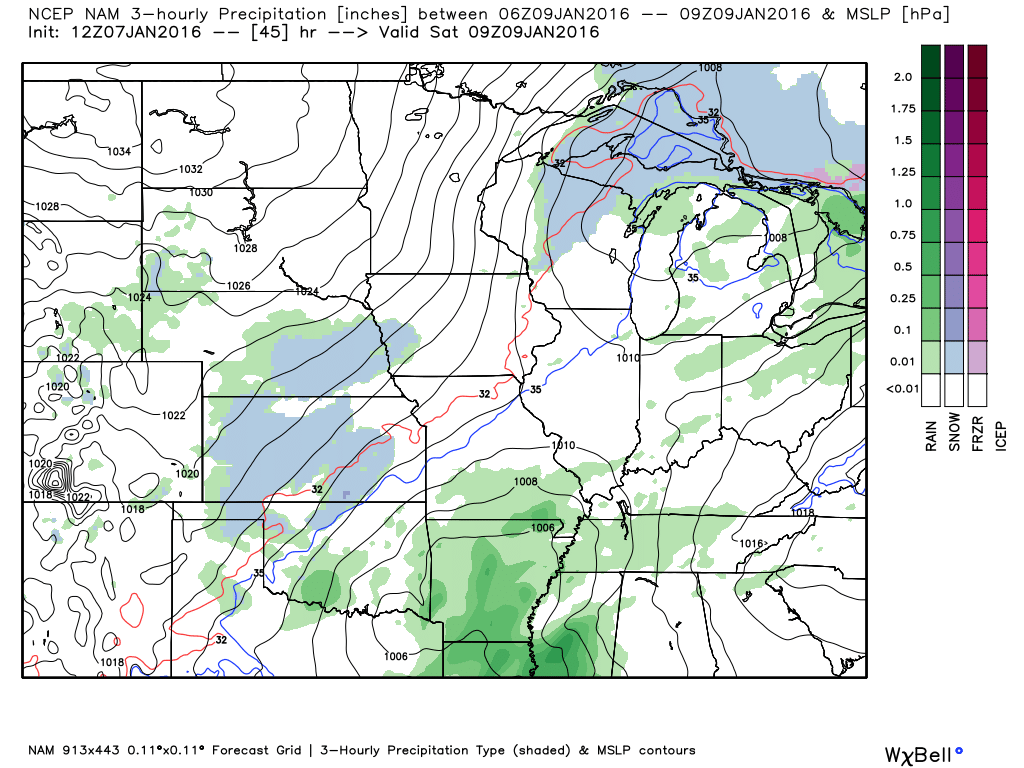
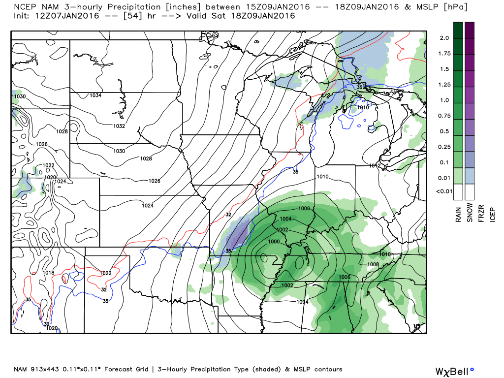
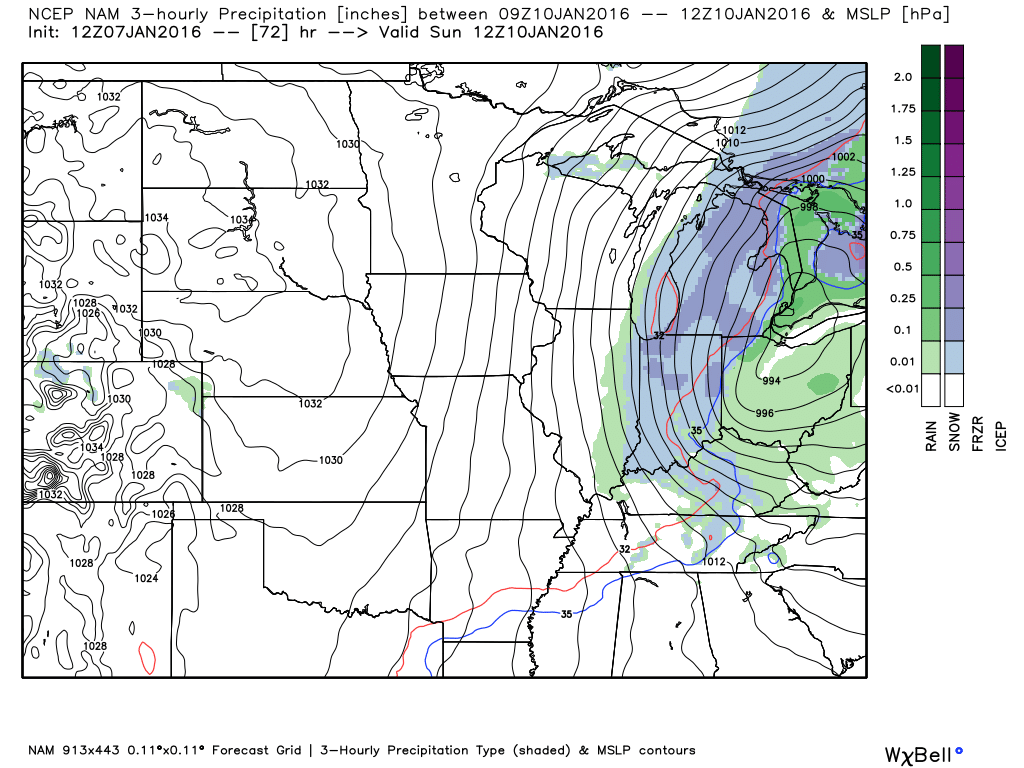
Let’s watch how the NAM model handles the area of low pressure. The low would be where the isobars (equal lines of pressure) are closed off in a circle.
This first image is for 3 am on Saturday morning. The low is forming over Arkansas. Rain showers are represented by the green colors. Blue would be snow showers.
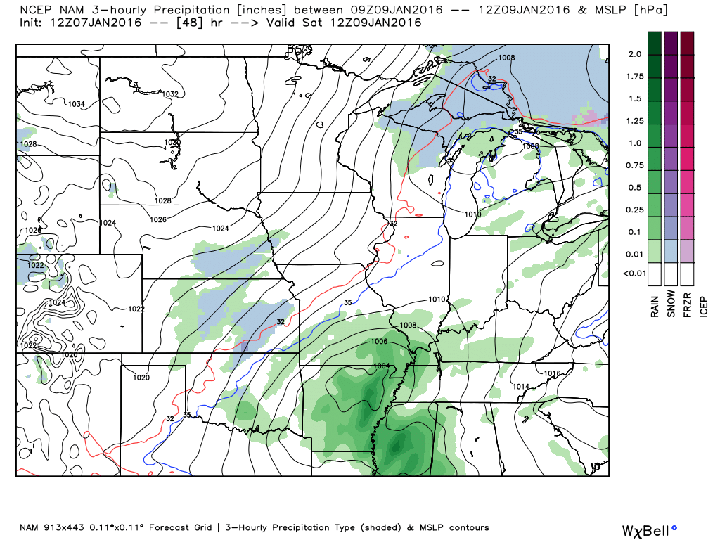
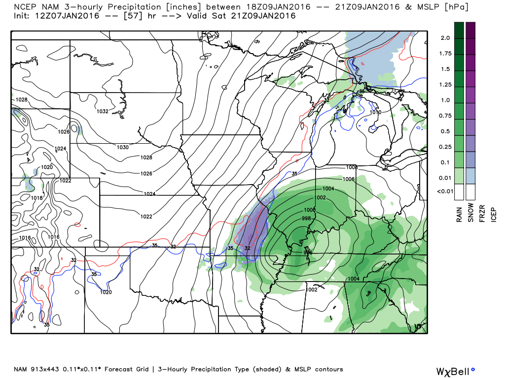
This next image is for 6 am on Saturday morning. The low is over northern Arkansas. See the closed isobars? That is the area of low pressure. It is moving northeast. Rain covers much of our area on Saturday morning.
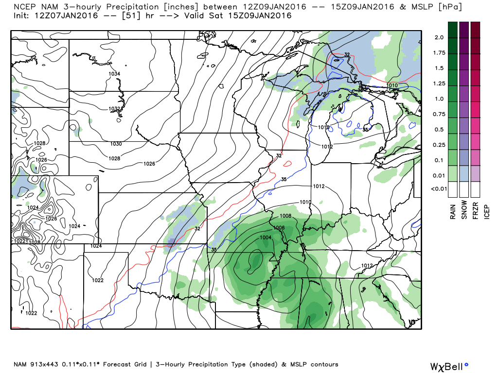
This is 9 am on Saturday morning (below). Rain covers are area. The low continues to strengthen. You can see a hint of blue on the far west side of the rain shield.
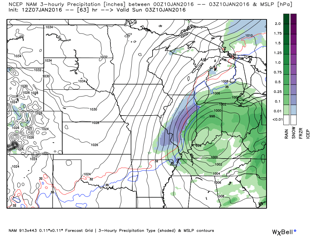
By the lunch hour on Saturday you can see the low is moving into southeast Missouri and northwest Tennessee. Snow has developed as the low tightens and colder air is pulled into Missouri. Snow over central Missouri. Rain for our entire area. Maybe thunder over Kentucky and Tennessee.
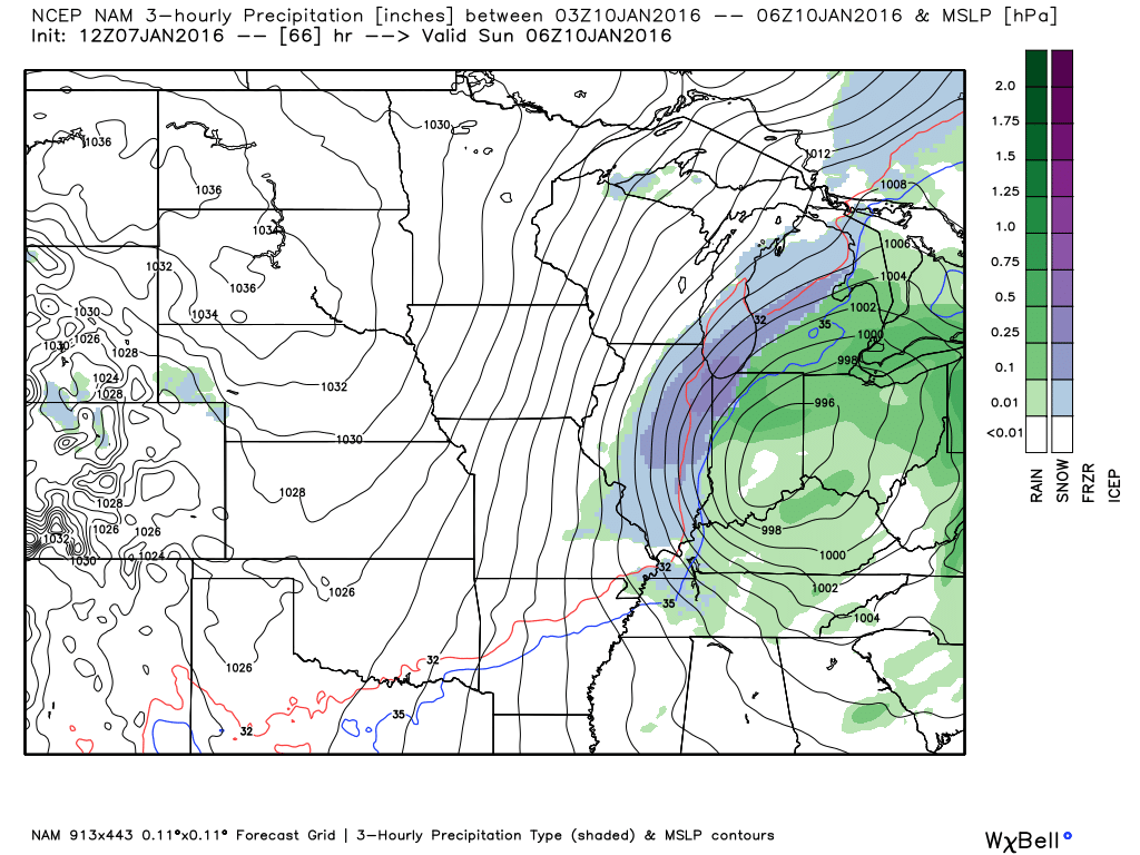
This next image is for 2-3 pm on Saturday afternoon. Rain covers our area. See the circle over west Kentucky and southern Illinois? That is the area of low pressure. Snow blankets parts of south central Missouri into the St Louis area. Brief period of moderate to heavy snow is possible on the west side of the system. Again, mostly rain in our region.
This next image is for Saturday evening around 9 pm. The low has moved into southern Indiana. Rain is changing to snow over parts of our area. Mainly our western and northwestern counties. As the system pulls away the precipitation will wind down.
This next image is for Saturday night around 11 pm. You can see the low is moving into eastern Indiana and Ohio. Perhaps some light snow showers in our area.
Finally, this last image shows you Sunday morning around 2 am to 3 am
Patchy light snow showers or even freezing drizzle is possible in our local area. Again, the main concern might end up being some black ice.
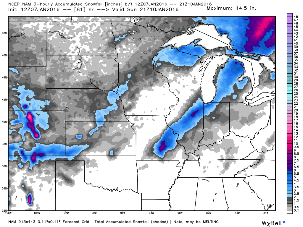
This next map is what the NAM thinks will happen as far as snow accumulation.
Low confidence on this map. Models don’t always handle snow accumulation very well. BUT, with that said, if there were going to be snow accumulation then the area in blue would stand the best chance. Mostly outside of my forecast counties.
NOW, if the storm track shifts then this map would change. The track of the area of low pressure is always key to where snow accumulates. If the low were to shift further south and east then the map might change. Just keep that in mind.
I don’t like to see snow accumulation forecast maps more than 24 hours in advance. Right now we are at 48 hours.
By the way, the gray areas represent a dusting or less of snow. Dark gray close to the blue represents around one inch of snow.
Cold air will stick around into next week. Small chance of some snow flurries on Monday night or Tuesday as another system passes our region.
I am not tracking any other snow or ice system, at this time.
Clickable watch and warning map


Here are the current river stage forecasts. You can click your state and then the dot for your location. It will bring up the full forecast and hydrograph.
Click Here For River Stage Forecasts…

See discussion below.

Friday – No snow or ice anticipated.
Saturday – Snow is possible over our northwest counties on Saturday. That would include areas like Ste Genevieve County, Missouri and perhaps Perry County, Missouri the north and northeast from there. Also west and northwest from there. A period of light snow will be possible across our entire area on Saturday afternoon (late) and Saturday night. Small chance for a wintry mix on Sunday morning over western Kentucky, as well. Main concern will be any moisture left on roadways. This moisture could freeze as temperatures fall into the twenties Saturday night.
Sunday – Small chance for patchy light snow or freezing drizzle over western Kentucky. Small chance. Also, there could be patchy slick spots on roads Sunday morning. Part of this will depend on whether light snow falls on Saturday night. And, if moisture is left on roadways from Saturday’s rain.
Monday/Tuesday – At this time no snow or ice is expected on Monday. Another weak system will approach our region on Monday/Tuesday. I suppose I can’t completely rule out snow flurries.

Updated rain and snow probabilities for the weekend. Also mentioned patchy ice on roadways as temperatures fall into the 20s.

Some accumulating snow is possible on Saturday and Saturday night, especially over parts of southeast Missouri and southwest Illinois. The further north and west you travel the more likely snow could accumulate. Believe most of my forecast counties won’t experience much in the way of snow accumulation. Perhaps Ste Genevieve County, Missouri towards Jefferson County, Illinois. Low confidence on sticking snow.
Patchy ice is possible on roadways Saturday night and Sunday morning. Falling temperatures could freeze any moisture left on roadways.

Avoid flooded roadways. Rivers remain high.
Monitor updated forecasts concerning the potential of snow on Saturday and Saturday night over our northwest counties.
I am also a concerned about black ice. Black ice forms as cold air moves into an area where rain has recently fallen. Wet pavements can freeze if the cold air moves in fast enough. That is a possibility on Saturday and Saturday night. If you have travel plans on Saturday/Saturday night then you will want to monitor updated forecasts.

Two wild cards in this update
Some thunder possible on Saturday over western Kentucky and western Tennessee. Severe weather risk appears minimal.
SNOW? Will our northwest counties pick up a dusting or so of snow? It does appear possible. A band of accumulating snow is likely to occur to the northwest of the area of low pressure. That could include some of our southeast Missouri counties and southwest Illinois counties. Monitor updates

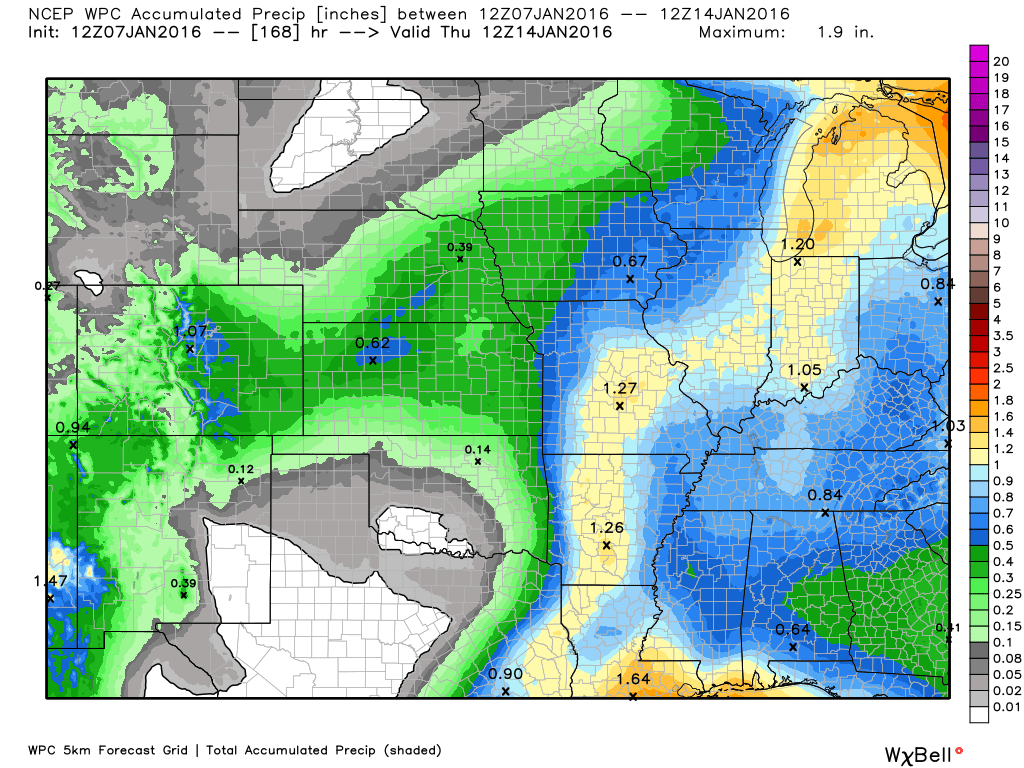
How much precipitation should we expect over the next few days?
Our next weather system arrives on Friday night into Saturday night. Expect rain to redevelop in our area on Saturday morning. Rain will linger into Saturday night. If cold air moves in quick enough then some could experience a burst of snow, as well.
These rainfall totals reflect the time period from Thursday into Sunday morning. This covers BOTH events.

Can we expect severe thunderstorms over the next 24 to 48 hours? Remember that a severe thunderstorm is defined as a thunderstorm that produces 58 mph winds or higher, quarter size hail or larger, and/or a tornado.
The thunderstorm threat level will be a ZERO on Thursday and Friday. I am now monitoring Saturday for possible thunderstorms. Believe any severe weather risk would be well to our south. But, perhaps some of our counties could experience lightning/thunder.
.
No risk of severe weather through Friday.
I am monitoring Saturday for possible storms in the region. This will be determined by the track of the area of low pressure. Not expecting severe weather. But, lightning will be possible.

Here are the current river stage forecasts. You can click your state and then the dot for your location. It will bring up the full forecast and hydrograph.
Click Here For River Stage Forecasts…
Here are some current forecast hydrographs. These will be updated each day with new information.


Smithland Lock and Dam

Paducah, Kentucky Forecast Stage

Cairo, Illinois

Cape Girardeau, Missouri

We have regional radars and local city radars – if a radar does not seem to be updating then try another one. Occasional browsers need their cache cleared. You may also try restarting your browser. That usually fixes the problem. Occasionally we do have a radar go down. That is why I have duplicates. Thus, if one fails then try another one.
If you have any problems then please send me an email beaudodson@usawx.com
WEATHER RADAR PAGE – Click here —
We also have a new national interactive radar – you can view that radar by clicking here.
Local interactive city radars include St Louis, Mt Vernon, Evansville, Poplar Bluff, Cape Girardeau, Marion, Paducah, Hopkinsville, Memphis, Nashville, Dyersburg, and all of eastern Kentucky – these are interactive radars. Local city radars – click here
NOTE: Occasionally you will see ground clutter on the radar (these are false echoes). Normally they show up close to the radar sites – including Paducah.


Here is the official 6-10 day and 8-14 day temperature and precipitation outlook. Check the date stamp at the top of each image (so you understand the time frame).
The forecast maps below are issued by the Weather Prediction Center (NOAA).


The latest 8-14 day temperature and precipitation outlook. Note the dates are at the top of the image. These maps DO NOT tell you how high or low temperatures or precipitation will be. They simply give you the probability as to whether temperatures or precipitation will be above or below normal.


Here are the current river stage forecasts. You can click your state and then the dot for your location. It will bring up the full forecast and hydrograph.
Click Here For River Stage Forecasts…

Who do you trust for your weather information and who holds them accountable?
I have studied weather in our region since the late 1970’s. I have 37 years of experience in observing our regions weather patterns. My degree is in Broadcast Meteorology from Mississippi State University and an Associate of Science (AS). I am currently working on my Bachelor’s Degree in Geoscience.
My resume includes:
Member of the American Meteorological Society.
NOAA Weather-Ready Nation Ambassador.
Meteorologist for McCracken County Emergency Management. I served from 2005 through 2015.
I own and operate the Southern Illinois Weather Observatory.
Recipient of the Mark Trail Award, WPSD Six Who Make A Difference Award, Kentucky Colonel, and the Caesar J. Fiamma” Award from the American Red Cross.
In 2009 I was presented with the Kentucky Office of Highway Safety Award.
Recognized by the Kentucky House of Representatives for my service to the State of Kentucky leading up to several winter storms and severe weather outbreaks.
I am also President of the Shadow Angel Foundation which serves portions of western Kentucky and southern Illinois.
There is a lot of noise on the internet. A lot of weather maps are posted without explanation. Over time you should learn who to trust for your weather information.
My forecast philosophy is simple and straight forward.
- Communicate in simple terms
- To be as accurate as possible within a reasonable time frame before an event
- Interact with you on Twitter, Facebook, and the blog
- Minimize the “hype” that you might see on television or through other weather sources
- Push you towards utilizing wall-to-wall LOCAL TV coverage during severe weather events
I am a recipient of the Mark Trail Award, WPSD Six Who Make A Difference Award, Kentucky Colonel, and the Caesar J. Fiamma” Award from the American Red Cross. In 2009 I was presented with the Kentucky Office of Highway Safety Award. I was recognized by the Kentucky House of Representatives for my service to the State of Kentucky leading up to several winter storms and severe weather outbreaks.
If you click on the image below you can read the Kentucky House of Representatives Resolution.

Many of my graphics are from www.weatherbell.com – a great resource for weather data, model data, and more


You can sign up for my AWARE email by clicking here I typically send out AWARE emails before severe weather, winter storms, or other active weather situations. I do not email watches or warnings. The emails are a basic “heads up” concerning incoming weather conditions.