We have our first sponsor for the blog. Milner and Orr Funeral Home and Cremation Services located in Paducah, Kentucky and three other western Kentucky towns – at Milner and Orr they believe in families helping families.
![]()

This forecast update covers far southern Illinois, far southeast Missouri, and far western Kentucky. See the coverage map on the right side of the blog.
Friday – Quite a few clouds. Some morning flurries possible/snow showers possible. Falling temperatures in the afternoon. Another blast of cold air. Northwest winds at 10-20 mph will make it feel even colder. Temperatures around 18 degrees in the morning and they will struggle to reach 20 degrees in the afternoon. Falling late in the day.
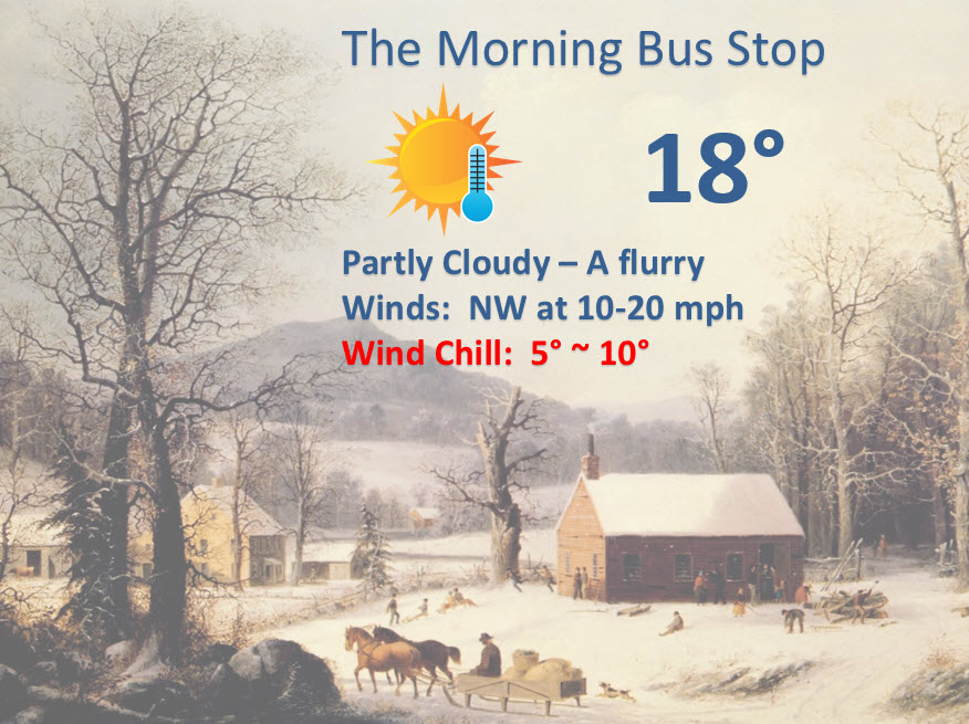
Friday School Bus Stop Weather – A few clouds and flurries possible. Temperatures around 18 degrees. Northwest winds at 10-15 mph. Wind chills in the single digits. Perhaps some gusts to 20 mph
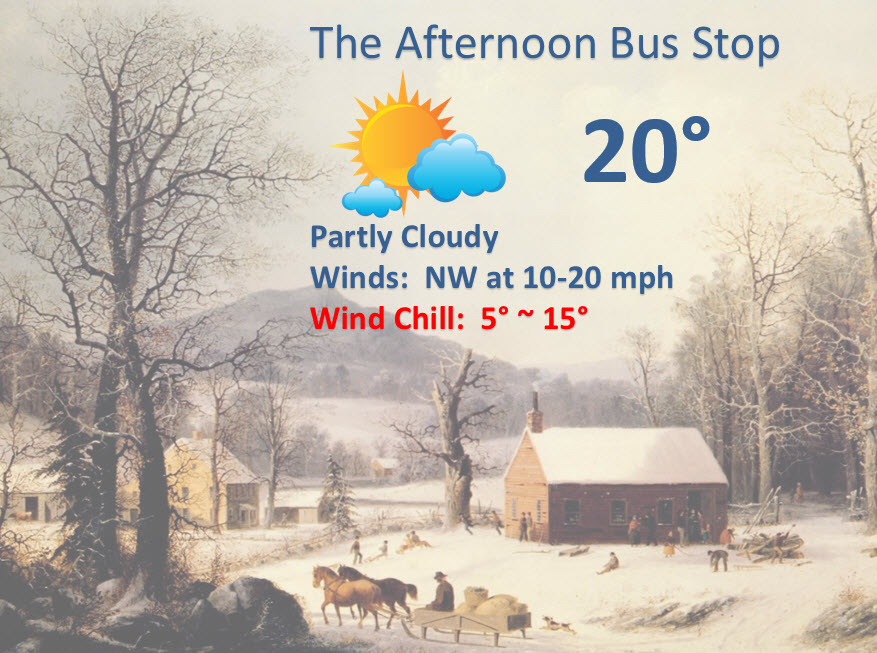
Afternoon School Bus Stop Weather – Partly cloudy. Falling temperatures in the afternoon. Temperatures around 20 degrees at the bus stop. Northwest winds at 10-15 mph. Wind chills in the single digits.
Friday night – Clearing and bitterly cold. Pipe busting temperatures in the 6-14 degree range. North winds at 5 mph becoming calm.
Saturday – Mostly sunny. Perhaps some high clouds in the afternoon. Chilly. High temperatures only in the 20’s. Winds becoming southerly at 5-10 mph.
Saturday night – Becoming cloudy. Low temperatures in the lower 20’s. Southerly winds at 5-10 mph.
Sunday – Cloudy with sleet and freezing rain developing during the afternoon and evening hours. Some of the precipitation may be rain in areas that have temperatures rise above 32 degrees. High temperatures in the 30’s. South winds at 10 mph. Some travel problems are possible. See the winter storm discussion part of the blog below

Current Temperatures Around The Local Area


An explanation of what is happening in the atmosphere over the coming days.
Weather Headlines
1. Another cold shot arrives today
2. A precipitation event is unfolding for Sunday-Monday
3. Another precipitation event possible towards Wednesday or Thursday
We have a lot to discuss in the winter storm outlook. Scroll down to read the latest details on the weekend storm system.
Today is going to be another cold one. A cold front is going to move through the area and temperatures should fall this afternoon and evening. By Saturday morning we will be back into the single digits and lower teens. It will once again be a BRRRR morning. The good news is that the kids won’t have to wait at the bus stop on Saturday morning.
There could be some snow flurries or snow showers today along the cold front.
Temperatures on Saturday, with quite a bit of sun, will not rise much. Expect highs only in the 20’s. I wish I had warmer news for you. But, I don’t.
I have been telling you about a possible precipitation event for the upcoming weekend. That is still on the table and seems almost certain. The question is what type of precipitation will fall. That has always been the question.
I go into detail about the potential in the winter storm outlook (below).

No Major changes in the forecast. I have tweaked temperatures a little bit. Nothing major.

Very cold temperatures once again tonight. Saturday morning will be bitterly cold. Don’t forget our outdoor pets. They are suffering through this cold snap, as well.
A winter weather event is possible on Sunday into Monday. See the winter storm discussion part of the blog below.

The wild card tells you where the most uncertainty is in the current forecast.
Wild card in this forecast – the wild card is going to be Sunday’s wintry precipitation. Will temperatures rise enough to prevent sleet and freezing rain from causing travel problems. A lot of questions remain on this system.

Can we expect severe thunderstorms over the next 24 to 48 hours? Remember that a severe thunderstorm is defined as a thunderstorm that produces 58 mph winds or higher, quarter size hail or larger, and/or a tornado.
Thunderstorm threat level is ZERO
No concerns about thunderstorms with temperatures this cold!


Will I need to take action?
Very cold air will settle into the region tonight and tomorrow morning.
Protect pipes. Don’t forget about our outdoor friends. They are suffering through this cold snap, as well.
Anyone with travel plans Sunday into Monday should monitor the latest forecast. Some wintry weather will be possible in or near our region.

How much rain should this system produce over our region?
Now, this is an early estimate. These totals are 100% dependent on the storms track. The intensity of the storm. I don’t have a lot of confidence just yet on how much precipitation will fall on Sunday into Monday. But, let’s give it a shot
Let’s step through this day by day
Overall the precipitation totals should be less than 0.50″ (again this is dependent on the evolution of the system).
By Sunday afternoon you can see that precipitation is moving into the area. Scattered amounts of 0.01 to 0.05″. Not a lot, but if that is sleet and freezing rain then it could cause problems.
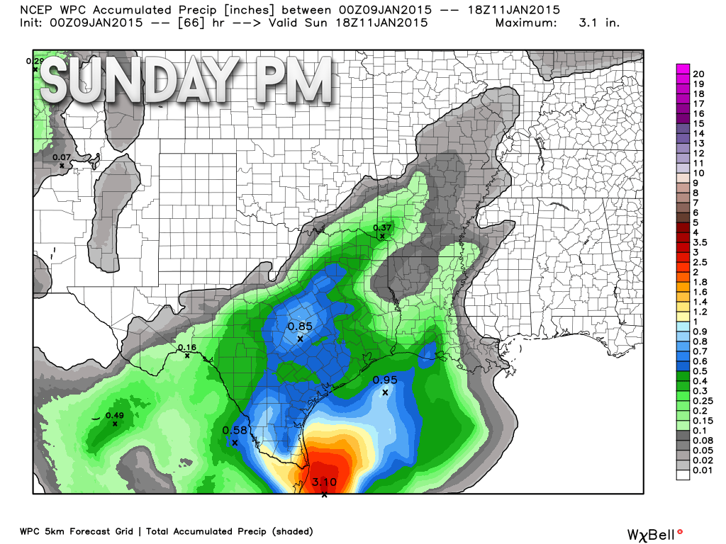
Let’s move into Monday morning (1 am) – more and more precipitation has spread into the area. Amounts by this time are in the 0.10″ to 0.20″ range. Still not a lot, but if frozen then it would cause some travel problems.
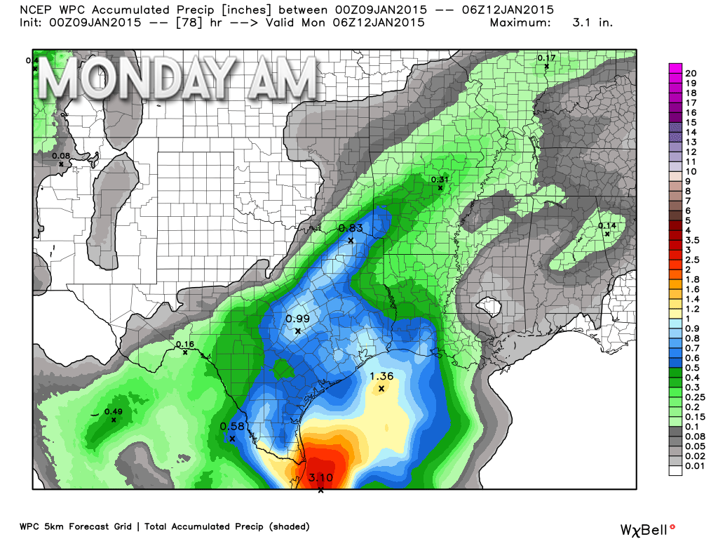
By 7 am on Monday morning these are the expected totals (this is for the entire event – totaled up – below)
By this time totals should be in the 0.20″-0.40″ range. You can see the heaviest totals are towards Poplar Bluff, Missouri and northeast Arkansas.
The last image below shows you the final totals.
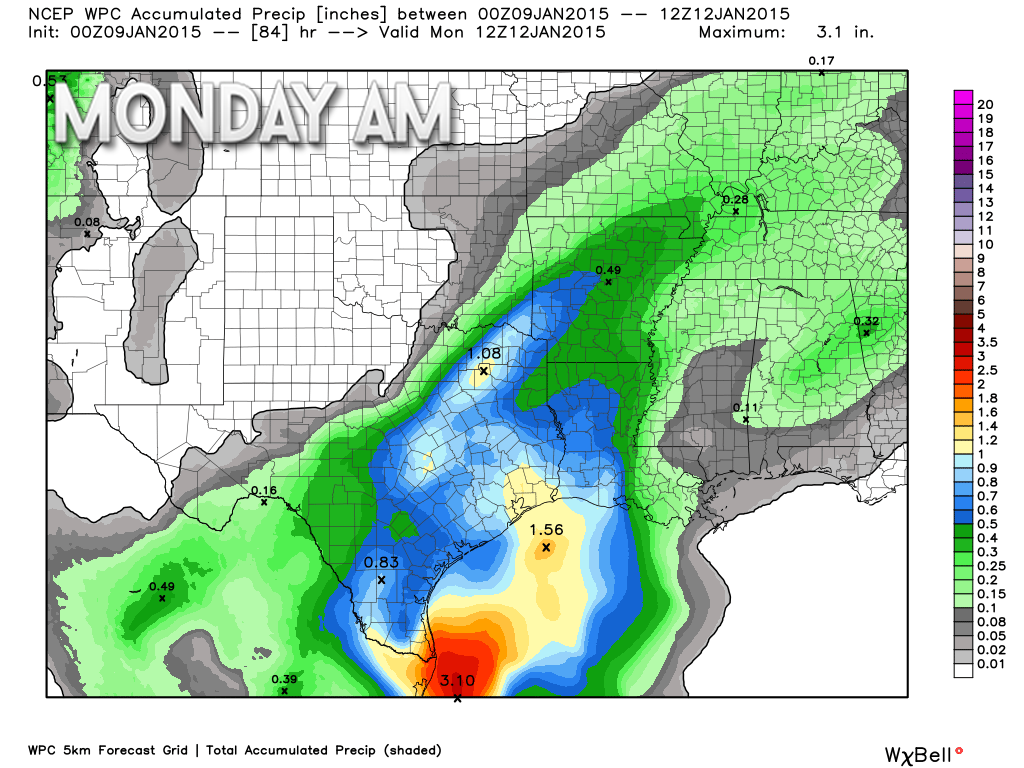
By Tuesday morning the precipitation should come to an end. These are the final expected totals.
This is the very latest forecast information (as of 6 am Friday morning). A band of heavier precipitation stretches across parts of our region. This has increased from previous forecast data.
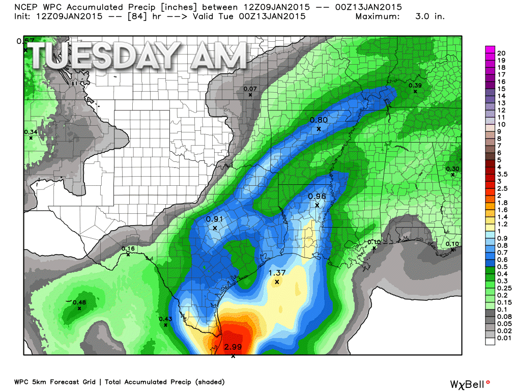
With all of that said, this storm is still being sampled by the models. I don’t have a lot of confidence in the final outcome. Above are the expected totals. We will see if there are changes in the data as we move into tonight and tomorrow. If so then I will update.
We have a new sponsor! G&C Multi-Services out of Paducah, Kentucky. G & C Multi-Services is a service provider in Western Kentucky that provides industrial and commercial equipment fabrication, machine troubleshooting, repair and maintenance, and installation. They can custom fabricate steel, stainless, and aluminum products per customer specifications.
Visit their web-site here. Or click the ad below! They have a Facebook page and it can be viewed here.


Concerns for the upcoming days…
1. Wintry mix and rain arrives on Sunday
2. Timing is still in question. I am thinking Sunday afternoon.
3. Very unsure on where the 32° line should be placed during Sunday afternoon into Monday morning.
4. Some hazardous travel conditions are possible over at least portions of the area
5. If this system remains all freezing rain then some accumulation of ice can be expected on trees and other surfaces.
Well, I know some of you want snow. We do have a wintry precipitation event developing for Sunday into Sunday night. Unfortunately, this appears to be more of an ice event than a snow event. Sleet and freezing rain. I guess that is not what you wanted to hear?
These are still a lot of questions on how Sunday into Monday unfolds. I have to figure out exactly where the freezing line will end up during this time frame.
A southwest wind will develop on Saturday night and Sunday. This will be the beginning of a slight warming trend. I say slight because temperatures on Sunday will likely not get out of the 30’s. But, how much into the 30’s is the question.
Precipitation is forecast to develop Saturday night across Arkansas and Oklahoma. This precipitation will slowly spread east/northeast into southern Missouri by late Saturday night or Sunday morning. From there it will spread into the rest of our area.
It appears precipitation will reach southern Illinois and western Kentucky on Sunday afternoon and evening. By then temperatures should have risen into the lower or middle 30’s. Some data indicates upper 30’s and even lower 40’s. I am not buying into the warmer temperatures. Not at this point, at least.
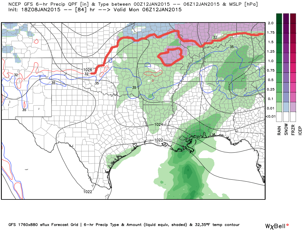
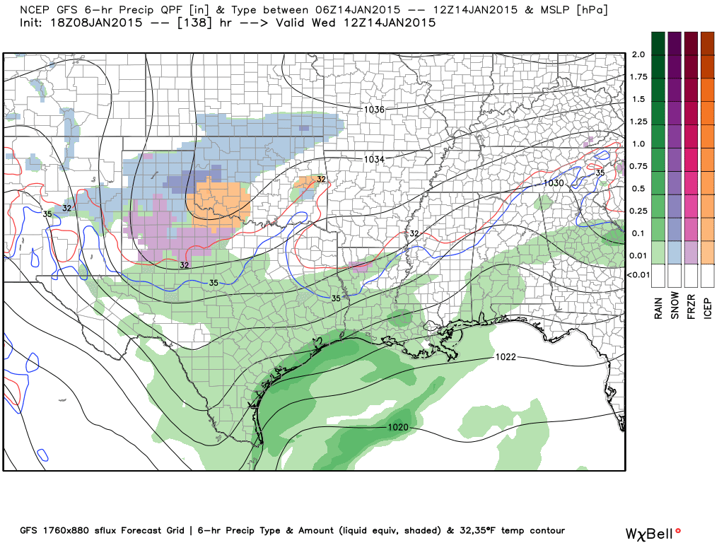
Here is what the GFS model is showing for Sunday (map below). See the freezing rain and sleet spreading into our region? That would be the colors on the map. Green would be rain.
Here is the 11 pm weather map for Sunday night – this is the GFS model. The red line would be the 32 degree line. You can see how it slices through our northern counties. The blue color is snow, the purple color is sleet/ice, and the green would be rain. You can also see a pocket of cold air over the Missouri Ozarks. Ice? Possibly lingering longer over the Ozarks.
Now, with that said – this is the GFS model. Models have a hard time forecasting cold air. I tend to not trust the models when it comes to temperature profiles over our region. Shallow cold air can be tricky to displace. If the cold air lingers longer than the models are forecasting then we will have more freezing rain and sleet vs rain.
The EC model actually keeps most of our region at the 32 degree mark and below through most of Sunday night.
This is a stay tuned event.
Temperatures on Sunday night may fall a few degrees. If this is the case then precipitation could stay in the form of sleet or freezing rain or change back to sleet and freezing rain. I say change back because temperatures may rise enough on Sunday afternoon to change the wintry mix to all rain over some of our counties.
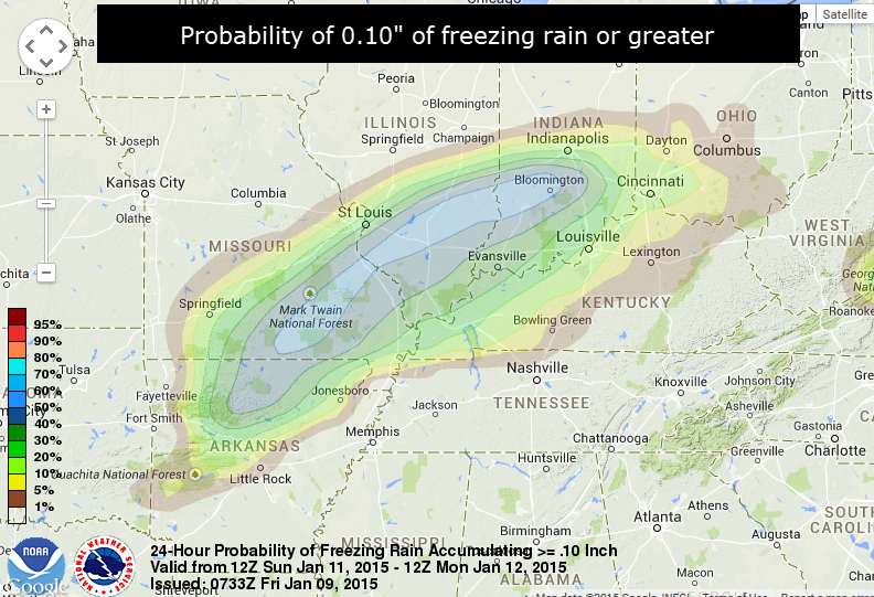
Here is the CURRENT probability forecast for 0.10″ or greater of freezing rain. The light blue is currently the area of highest risk. The probabilities then decrease as the colors move outward. This map will fluctuate over the coming days as new data arrives. But, it does give you an idea of where the data is pointing to at this time.
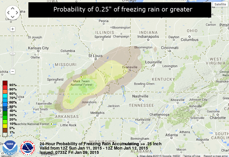
Let’s take a look at the probabilities for 0.25″ or greater of freezing rain falling. The green area inside of the yellow is the highest probability on this particular map (near Mark Twain National Forest). Again, you get the general idea of where the data is pointing. This could shift a bit further east and southeast if the cold air does not move out fast enough.
I told you there were a lot of questions left on the table concerning this system.
This system is tricky because temperatures may hover around 32 degrees over portions of our region through much of the event (into Sunday night). As a matter of fact, some of the data indicates the precipitation never does change to rain over our northern counties.
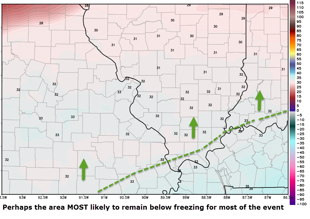
Here is where the freezing line might be place for most of the event. First thoughts – subject to changes as we move forward.
Freezing rain and sleet are more likely to turn to all rain across the Missouri Bootheel and along the Kentucky and Tennessee border on Sunday afternoon/evening.
The questionable areas are going to be southeast Missouri and southern Illinois. Also in question will be parts of western Kentucky.
The good news is that this does not appear to be a huge precipitation event. Some data does indicate higher totals. For now, however, I am thinking less than 0.50″. Of course if most of that falls as freezing rain and sleet then we would have problems.
If you have travel plans on Sunday into Monday morning then I would advise you to check back frequently for updated information. I am sure there will be changes over the coming 24 to 48 hours. Many times forecasters don’t have a handle on temperatures until the day of an event (in situations like this). I believe that might be the case this time around.
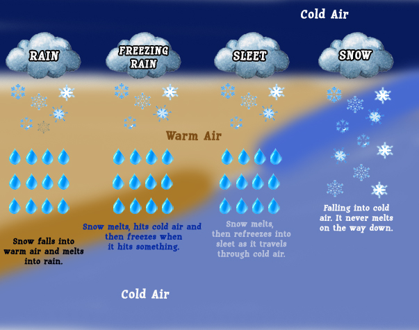
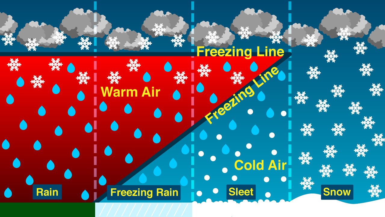
Let’s talk about the difference between rain, freezing rain, sleet, and snow. These different types of precipitation all depend on what the air temperatures is ALOFT. What happens well above our heads is what is important. If the entire column of air above us is below 32 degrees then normally that means snow. If there is a wedge of warmer air aloft and it is deep enough then we have freezing rain (assuming the surface temperature is at 32 degrees or low). If the warm air layer is not very thick then we can end up with sleet. Here are some graphics that I found online to illustrate the point
and
(as always click the image for a larger view)
Again, notice how thick the red zone is? That is the warm air layer that I mentioned. The thicker the warm air layer the more likely your snowflake is going to melt. If the warm layer extends all the way to the ground then you end up with just plain old rain.

The next weather event may impact our region on Wednesday and Thursday. Once again this event is anything but certain. The storm track is going to be key as to whether precipitation spreads into our region.
The EC model is sniffing this storm out and has been for a few days. The area of low pressure is forecast to develop well to our south and move east/northeast. This may mean that precipitation will occur in the Tennessee Valley, but stay south of our counties. However, with that said – if the area of low pressure a tad further north then it would be game on for precipitation into our counties.
Temperatures might be cold enough for this to be a snow event (if it occurs at all).
Here is what the GFS model is showing for the system. You can see on Wednesday morning that precipitation is developing well to our west and southwest. This run of the model actually shears the system apart as it moves east. It does not bring any snow into our region. Other models, however, do bring precipitation into our region.
This is a wait and see at this point. I am interested in the potential because the EC model has been showing it on/off for awhile. I think the potential for a snow event is possible in or near our region. It could be a southern storm. That would mean better chances of snow along the KY/TN border or even down into Tennessee.
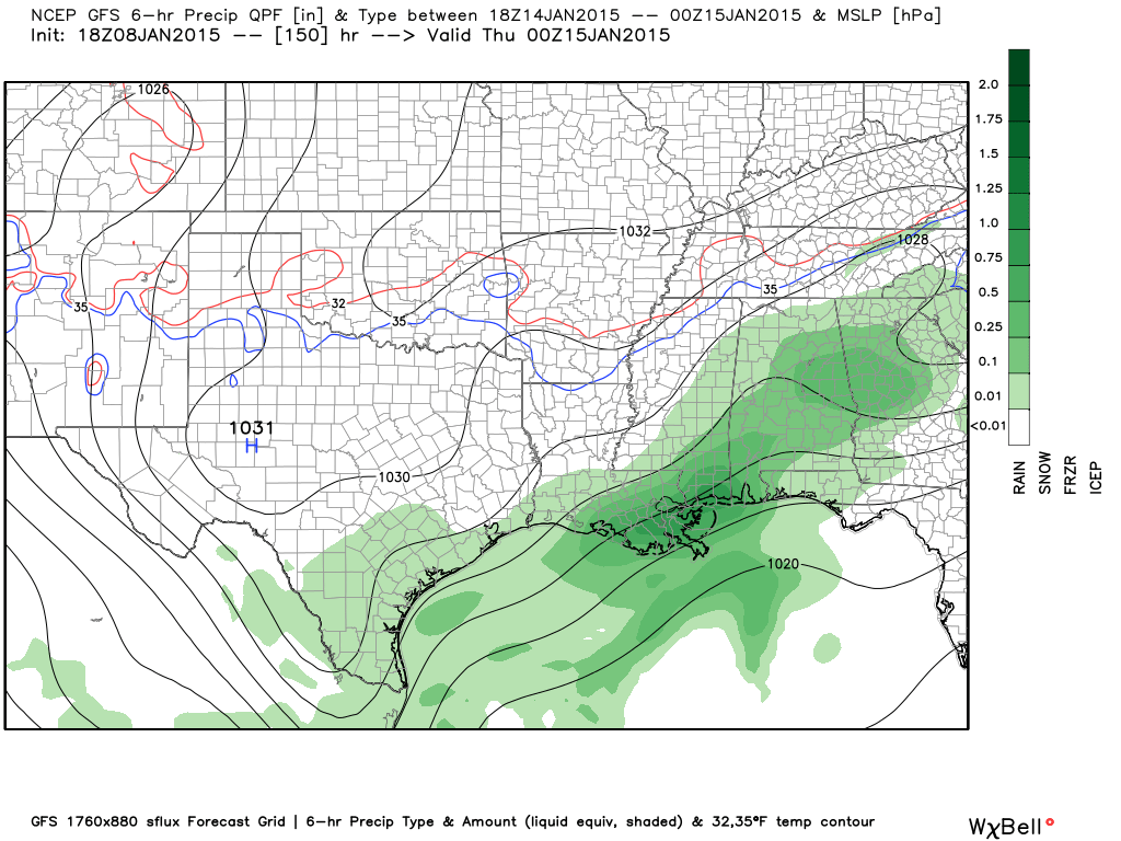
Here is that Wednesday morning GFS weather map. The blue is snow – orange is ice. Green would be rain. You can see it spreading eastward. But, check out the image below it. POOF – everything is shunted south.
This is the Wednesday evening GFS weather map. See how the precipitation has been shunted well to our south? That leaves our region dry.

We have regional radars and local city radars – if a radar does not seem to be updating then try another one. Occasional browsers need their cache cleared. You may also try restarting your browser. That usually fixes the problem. Occasionally we do have a radar go down. That is why I have duplicates. Thus, if one fails then try another one.
If you have any problems then please send me an email beaudodson@usawx.com
WEATHER RADAR PAGE – Click here —
We also have a new national interactive radar – you can view that radar by clicking here.
Local interactive city radars include St Louis, Mt Vernon, Evansville, Poplar Bluff, Cape Girardeau, Marion, Paducah, Hopkinsville, Memphis, Nashville, Dyersburg, and all of eastern Kentucky – these are interactive radars. Local city radars – click here
NOTE: Occasionally you will see ground clutter on the radar (these are false echoes). Normally they show up close to the radar sites – including Paducah.

Regional Radar – Click on radar to take you our full radar page.


Regional Radar
![]()
Current WARNINGS (a warning means take action now). Click on your county to drill down to the latest warning information. Keep in mind that there can be a 2-3 minute delay in the updated warning information.
I strongly encourage you to use a NOAA Weather Radio or warning cell phone app for the most up to date warning information. Nothing is faster than a NOAA weather radio.


Color shaded counties are under some type of watch, warning, advisory, or special weather statement. Click your county to view the latest information.

Missouri Warnings

Illinois Warnings

Kentucky Warnings

Please visit your local National Weather Service Office by clicking here. The National Weather Service Office, for our region, is located in Paducah, Kentucky.

Here is the official 6-10 day and 8-14 day temperature and precipitation outlook. Check the date stamp at the top of each image (so you understand the time frame).
The forecast maps below are issued by the Weather Prediction Center (NOAA).


The latest 8-14 day temperature and precipitation outlook. Note the dates are at the top of the image. These maps DO NOT tell you how high or low temperatures or precipitation will be. They simply give you the probability as to whether temperatures or precipitation will be above or below normal.


Many of my graphics are from www.weatherbell.com – a great resource for weather data, model data, and more


This blog was inspired by ABC 33/40’s Alabama Weather Blog – view their blog
Current tower cam view from the Weather Observatory- Click here for all cameras.

Southern Illinois Weather Observatory

The Weather Observatory

Southern Illinois Weather Observatory
WSIL TV 3 has a number of tower cameras. Click here for their tower camera page & Illinois Road Conditions

Marion, Illinois
WPSD TV 6 has a number of tower cameras. Click here for their tower camera page & Kentucky Road Conditions & Kentucky Highway and Interstate Cameras

Downtown Paducah, Kentucky
Benton, Kentucky Tower Camera – Click here for full view

Benton, Kentucky

I24 Paducah, Kentucky

I24 Mile Point 9 – Paducah, KY

I24 – Mile Point 3 Paducah, Kentucky

You can sign up for my AWARE email by clicking here I typically send out AWARE emails before severe weather, winter storms, or other active weather situations. I do not email watches or warnings. The emails are a basic “heads up” concerning incoming weather conditions.