We have our first sponsor for the blog. Milner and Orr Funeral Home and Cremation Services located in Paducah, Kentucky and three other western Kentucky towns – at Milner and Orr they believe in families helping families.
![]()

This forecast update covers far southern Illinois, far southeast Missouri, and far western Kentucky. See the coverage map on the right side of the blog.
Thursday – Mostly sunny – bitterly cold during the morning hours. Temperatures from below zero to 5 above zero. Temperatures will rise into the upper teens and lower 20’s by afternoon. Winds from the southwest at 10-15 mph and gusty. It will feel colder because of the winds. Wind chills from 0 to 10 above.
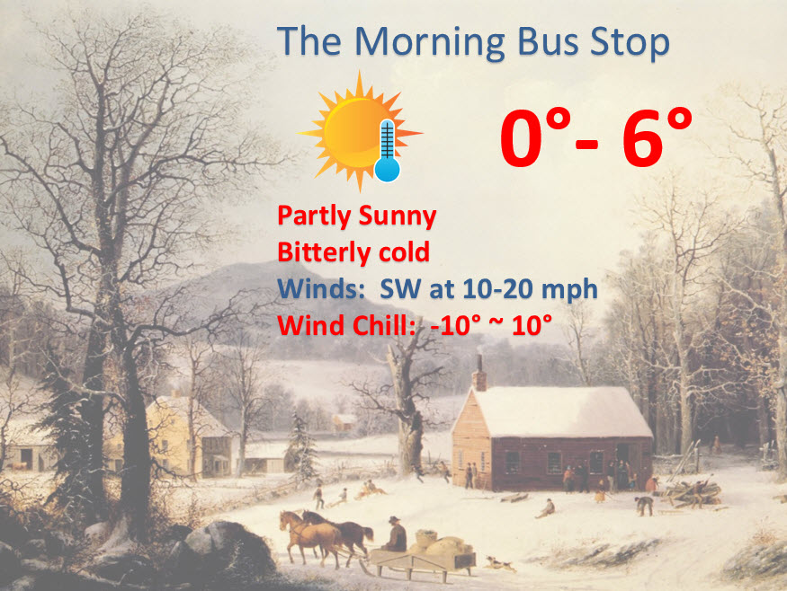
Thursday School Bus Stop Weather – Mostly clear and bitterly cold. Temperatures around 0 to 5 above. Variable winds at 5-10 mph. Wind chills from -5 to 5 above.
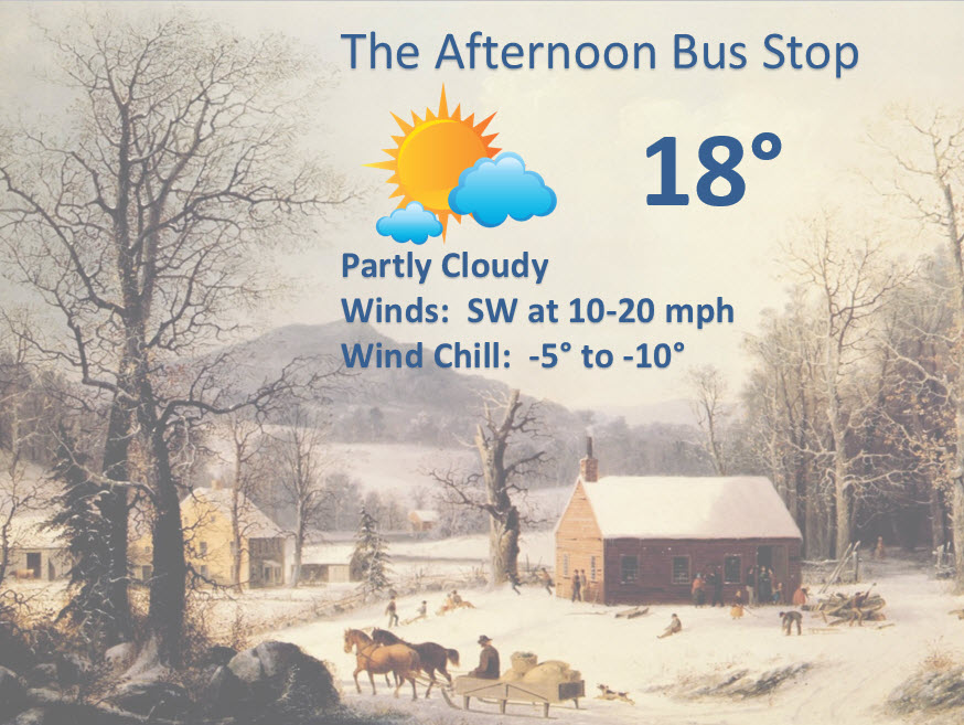
Afternoon School Bus Stop Weather – Mostly sunny. Temperatures in the lower 20’s. Southwest winds at 10-15 mph. Wind chills 0 to 10 above.
Thursday night – Partly cloudy and not as cold as Wednesday night! Flurries possible. Lows will be from 18 to 24 degrees. Southwest winds will become northwest at 10-15 mph. Gusty at times.
Friday – Partly cloudy. Chilly. Flurries possible. High temperatures only from 18 to 24 degrees. Northwest winds at 10-15 mph and gusty at times.
Friday night – Bitterly cold once again. Low temperatures from 4 to 8 degrees. Northwest winds at 5-10 mph.
Saturday – Partly cloudy and cold. High temperatures only in the 20’s. Light winds.

Current Temperatures Around The Local Area


You should be able to see the cold air on the satellite image this morning. All that milky right = cold air!


An explanation of what is happening in the atmosphere over the coming days.
NOTE: To keep things going 🙂
I am looking for sponsors/donors (outside of the ad spaces on the blog) for the weather data that I put out each day. That includes the WeatherTalk blog, the Weather Observatory web-site, the radars, and everything else you see on a daily basis.
PayPal has an option where you can set up a recurring payments. This is basically like a subscription. If a lot of people gave $5, $10, $20 a month (or other) then it would help A LOT.
Or if you don’t want to do a recurring option there is, of course, the option to donate once or every so often.
The expenses and time involved with all of the weather information is quite a bit. As you can imagine. I am not a paid meteorologist (as most of you know). I have done this as a volunteer service. This is my passion…which I am sure is obvious
I know a lot of businesses and other groups use the weather data on a regular basis to make business decisions.
This is the number one weather Facebook page in the area
I am the only meteorologist in surrounding states and the Tri-State area that answers your questions.
The weather blog is the number 1 weather blog in the area.
You can even go outside of our area and you won’t find anything quite like this. Perhaps James Spann out of Birmingham, Alabama would be the next closest comparison and Tom Skilling out of Chicago.
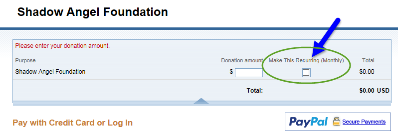
Here is the PayPal page where you can donate. Honestly, I am looking for a lot of people to do the recurring option. Then I have a solid and continuous support base. Note the option to check mark recurring payment on the page below.
Some of you don’t use PayPal.
My mailing address is
Beau Dodson
3954 Mermet Road
Belknap, IL
62908
Thanks, as always for your support.
Go here – then click donate at the bottom. That will take you to the proper page.
http://weathertalk.com/donate/
Example of the recurring option on PayPal.
Weather Headlines
1. Bitter cold today
2. Second wave of cold arrives Friday into Saturday morning
3. Precipitation this weekend into early next week
The long awaited blast of cold air has settled into the region. Temperatures dipped into the single digits yesterday afternoon over parts of southern Illinois and lower teens across western Kentucky. Bitterly cold winds made it feel even colder. Not the best weather for man or beast. Some of you even had a dusting of snow yesterday morning.
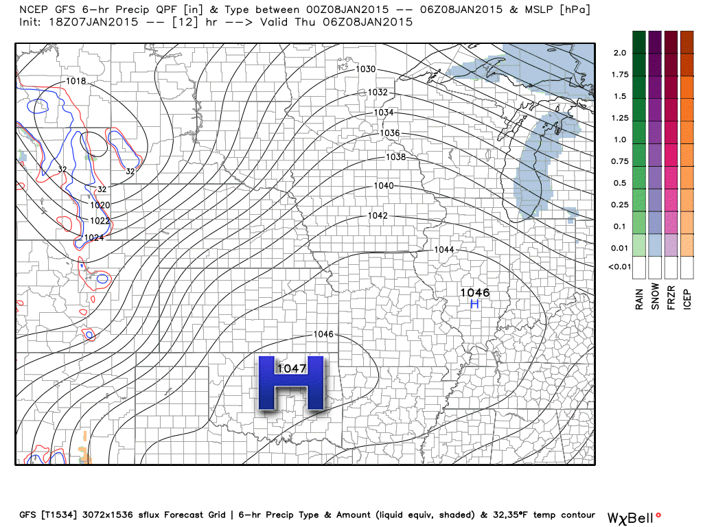
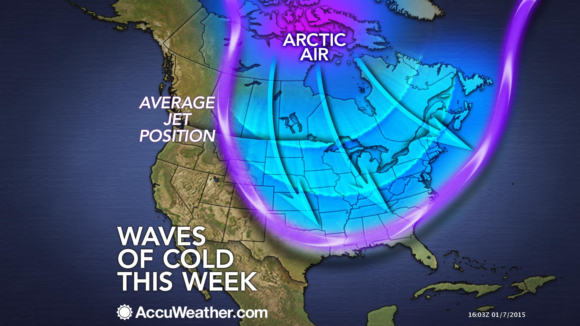
The reason for this cold air is an area of arctic high pressure that has moved into the central United States. Go check your barometers this morning. They are going to be just about as high as one could ever expect in our region.
Here is the weather map showing you the large area of high pressure. High pressure coming out of Canada during the winter months means bitterly cold air.
The good news is that temperatures will rise into the upper teens and lower 20’s later this afternoon. Is that good news? I guess it beats temperatures staying in the single digits.
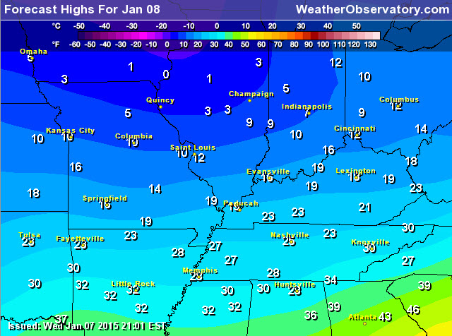
We will also see temperatures warm a bit by early next week. Let’s compare today’s highs with Monday’s highs
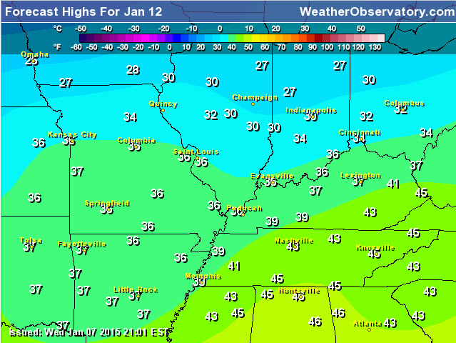
and here is Monday
Another blast of cold air will arrive on Friday into Saturday morning. I suspect we will see temperatures dip back into the single digits on Saturday morning.
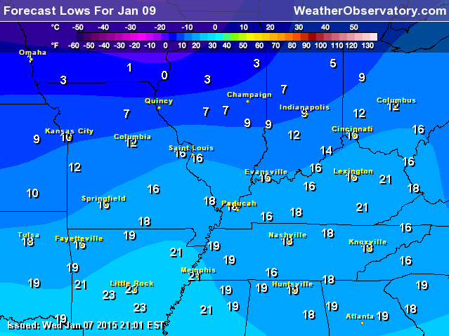
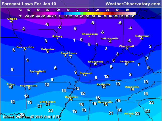
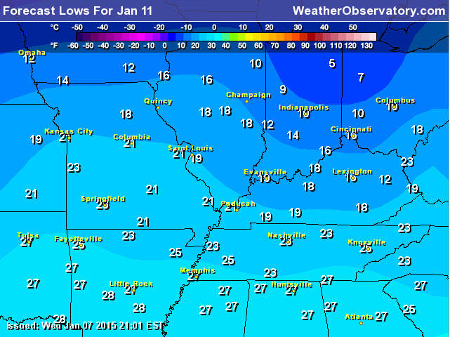
Let’s take a look at morning lows for the coming days
Friday morning lows (note that Saturday morning lows will be colder, once again)
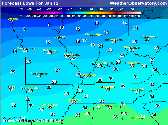
Saturday morning
Sunday morning lows (below)
Monday morning lows
You can see that temperatures do moderate a bit as we move into early next week.
The weather becomes more active as we push into the weekend and next week. Perhaps we will be dealing with some wintry precipitation? It appears at least possible.
Check out this photograph from the Wunderground.com web-site. Cold! Photo from East Dennis, MA


No major changes have been made to the short range forecast. Another blast of cold air arrives on Friday into Saturday morning.

Today’s cold temperatures, obviously are a concern. Don’t forget about your outdoor animals.
Another blast of cold air will bring single digits on Friday night and Saturday morning.
Closely monitoring Sunday into Tuesday for a wintry mix. Still not sure on temperatures. That means we may deal with all types of precipitation (including rain at some point)

The wild card tells you where the most uncertainty is in the current forecast.
Wild card in this forecast – how low will temperatures go on Friday night. Another cold blast will arrive during that time. Single digits are once again possible.

Can we expect severe thunderstorms over the next 24 to 48 hours? Remember that a severe thunderstorm is defined as a thunderstorm that produces 58 mph winds or higher, quarter size hail or larger, and/or a tornado.
Thunderstorm threat level is ZERO
No concerns about thunderstorms with temperatures this cold!


Will I need to take action?
Protection from cold air will be in order over the coming days. Single digits are again possible on Friday night and Saturday morning.
Don’t forget your outdoor pets. This cold weather impacts them, as well.
Monitor Sunday into early next week for precipitation which may include a wintry mix.

How much rain should this system produce over our region?
No precipitation through Saturday. See the discussion below for Sunday into next week. Precipitation is likely to occur during that time frame.
Some flurries or light snow is possible tonight and Friday. This is not forecast to accumulate.

Well, we do have something to talk about! A weather system will push into our region from the southwest United States on Sunday into early next week. As warmer air moves over the colder air we will see clouds and precipitation develop. There remain a lot of questions on the timing of the precipitation and temperature profiles over our region.
If the precipitation moves in on Sunday then it would likely be snow, sleet, and freezing rain. We would then need to monitor just how warm temperatures will become on Sunday night into Tuesday. If the system is weaker then the colder air may linger longer. If the system is stronger then warmer air may win the battle and the wintry mix changes to rain.
Right now it does appear that all of the precipitation will change over to rain at some point. The question is timing.
I have little confidence at this point on how this will play out (temperature wise). Stay tune and monitor updates on this potential winter weather event.

The big discussion in the long range is going to be the next weather maker late this weekend into early next week. As mentioned in the winter storm outlook, we may have to deal with a wintry mix on Sunday into Monday/Tuesday. Temperatures may rise enough by early next week to change everything over to rain. I can almost here the snow lovers booing. Just not your winter – thus far.
Precipitation type is still questionable. Another unknown is just how far north this system will track. The storm is not yet onshore. Once the storm can be sampled we will see the computer data start to merge on a solution. Right now the data is all over the place. Some of the models show quite a bit of rain. Some of the data shows quite a bit of freezing rain and sleet.
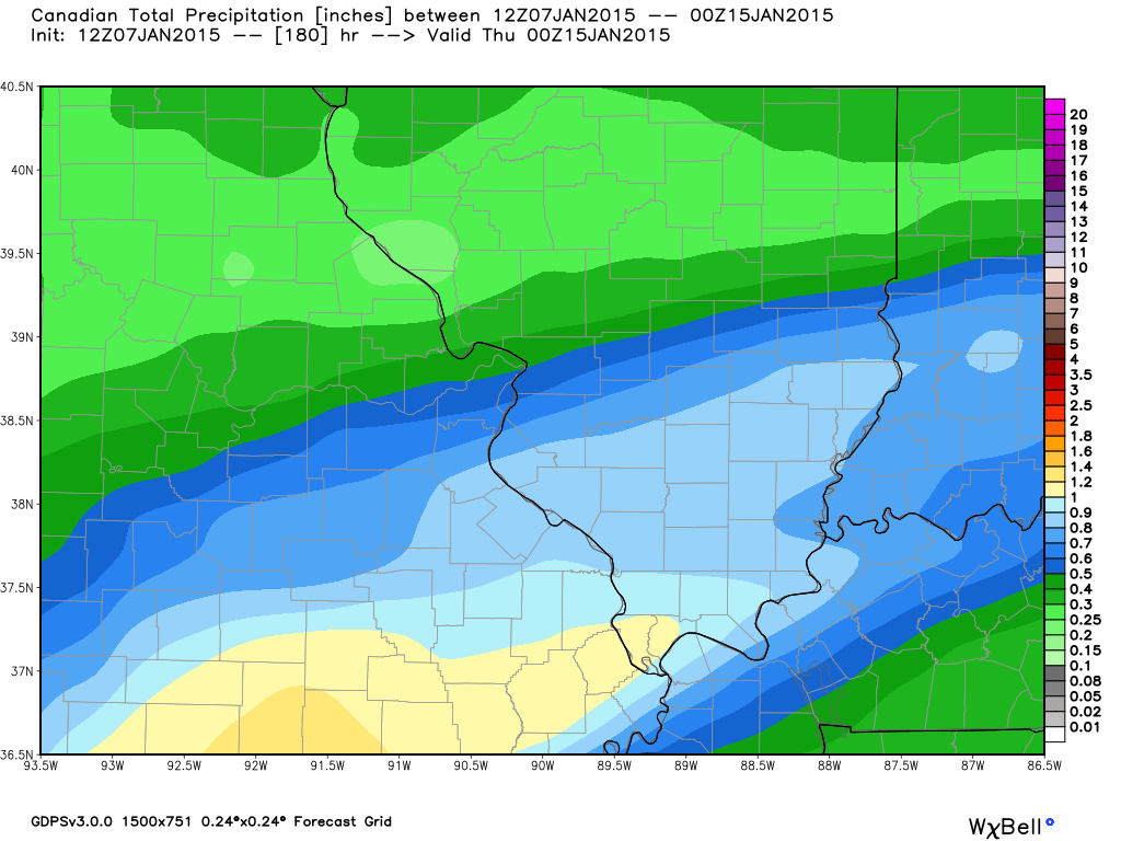
Let’s take a look at the Canadian model. This shows precipitation totals through next Wednesday. That is quite a bit of precipitation. The Canadian model is showing the precipitation beginning as a wintry mix and then changing to rain.
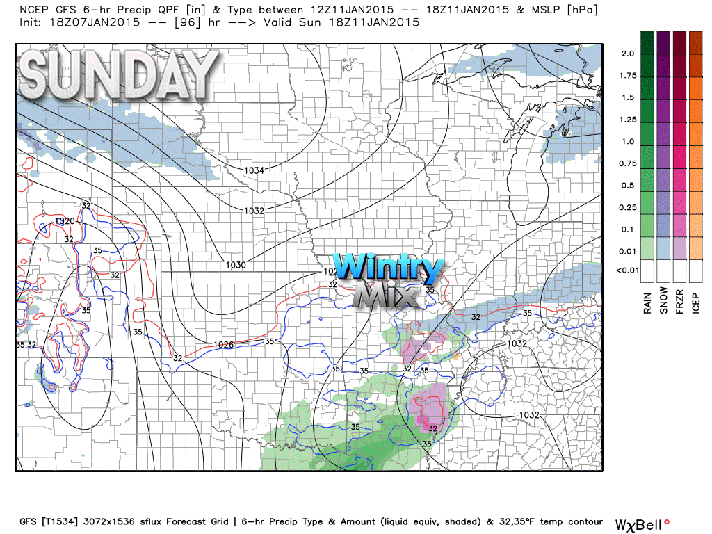
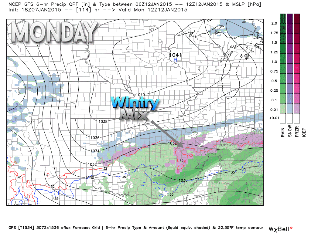
Let’s take a look at the GFS model.
It indicates a wintry mix of snow, sleet, and freezing rain spreading into our region by Sunday. The different colors are different precipitation types. Blue is snow. Pink is sleet and freezing rain. Green would be rain.
Images from www.weatherbell.com
This map is for Sunday around 12 pm. If this model is correct then we would have some precipitation spreading into the region as early as mid-morning. Again, this is just one models opinion.
Then this map below would be for Monday morning around 6 am. You can see quite a bit of precipitation spread across the region. The full winter mix of snow, sleet, and freezing rain. Also some rain over southern counties.
All of this depends on the speed of the system ejecting out of the southwest United States.

We have regional radars and local city radars – if a radar does not seem to be updating then try another one. Occasional browsers need their cache cleared. You may also try restarting your browser. That usually fixes the problem. Occasionally we do have a radar go down. That is why I have duplicates. Thus, if one fails then try another one.
If you have any problems then please send me an email beaudodson@usawx.com
WEATHER RADAR PAGE – Click here —
We also have a new national interactive radar – you can view that radar by clicking here.
Local interactive city radars include St Louis, Mt Vernon, Evansville, Poplar Bluff, Cape Girardeau, Marion, Paducah, Hopkinsville, Memphis, Nashville, Dyersburg, and all of eastern Kentucky – these are interactive radars. Local city radars – click here
NOTE: Occasionally you will see ground clutter on the radar (these are false echoes). Normally they show up close to the radar sites – including Paducah.

Regional Radar – Click on radar to take you our full radar page.


Regional Radar
![]()
Current WARNINGS (a warning means take action now). Click on your county to drill down to the latest warning information. Keep in mind that there can be a 2-3 minute delay in the updated warning information.
I strongly encourage you to use a NOAA Weather Radio or warning cell phone app for the most up to date warning information. Nothing is faster than a NOAA weather radio.


Color shaded counties are under some type of watch, warning, advisory, or special weather statement. Click your county to view the latest information.

Missouri Warnings

Illinois Warnings

Kentucky Warnings

Please visit your local National Weather Service Office by clicking here. The National Weather Service Office, for our region, is located in Paducah, Kentucky.

Here is the official 6-10 day and 8-14 day temperature and precipitation outlook. Check the date stamp at the top of each image (so you understand the time frame).
The forecast maps below are issued by the Weather Prediction Center (NOAA).


The latest 8-14 day temperature and precipitation outlook. Note the dates are at the top of the image. These maps DO NOT tell you how high or low temperatures or precipitation will be. They simply give you the probability as to whether temperatures or precipitation will be above or below normal.


Many of my graphics are from www.weatherbell.com – a great resource for weather data, model data, and more


This blog was inspired by ABC 33/40’s Alabama Weather Blog – view their blog
Current tower cam view from the Weather Observatory- Click here for all cameras.

Southern Illinois Weather Observatory

The Weather Observatory

Southern Illinois Weather Observatory
WSIL TV 3 has a number of tower cameras. Click here for their tower camera page & Illinois Road Conditions

Marion, Illinois
WPSD TV 6 has a number of tower cameras. Click here for their tower camera page & Kentucky Road Conditions & Kentucky Highway and Interstate Cameras

Downtown Paducah, Kentucky
Benton, Kentucky Tower Camera – Click here for full view

Benton, Kentucky

I24 Paducah, Kentucky

I24 Mile Point 9 – Paducah, KY

I24 – Mile Point 3 Paducah, Kentucky

You can sign up for my AWARE email by clicking here I typically send out AWARE emails before severe weather, winter storms, or other active weather situations. I do not email watches or warnings. The emails are a basic “heads up” concerning incoming weather conditions.