Saturday afternoon update…
Okay we have our travelers advisory for icy road conditions. It does cover a large chunk of the area. Pretty close to where I drew my line this morning, but ever a county or two further southeast. The advisory is for the accumulation of freezing rain. Freezing rain is rain that freezes instantly on contact with surfaces.
I have also added counties in the red circle that should experience a period of sleet and freezing rain at the start of the event. They may also have some slick roads. A bit more iffy in the red circle, but just be aware.
Also note that events like this usually have a TON of accidental falls with broken bones. The sidewalk might look wet, but it is actually ice.
Here are some graphics and the county outline of the official NWS advisory.
The red circle is where I believe some problems will also be possible early on.
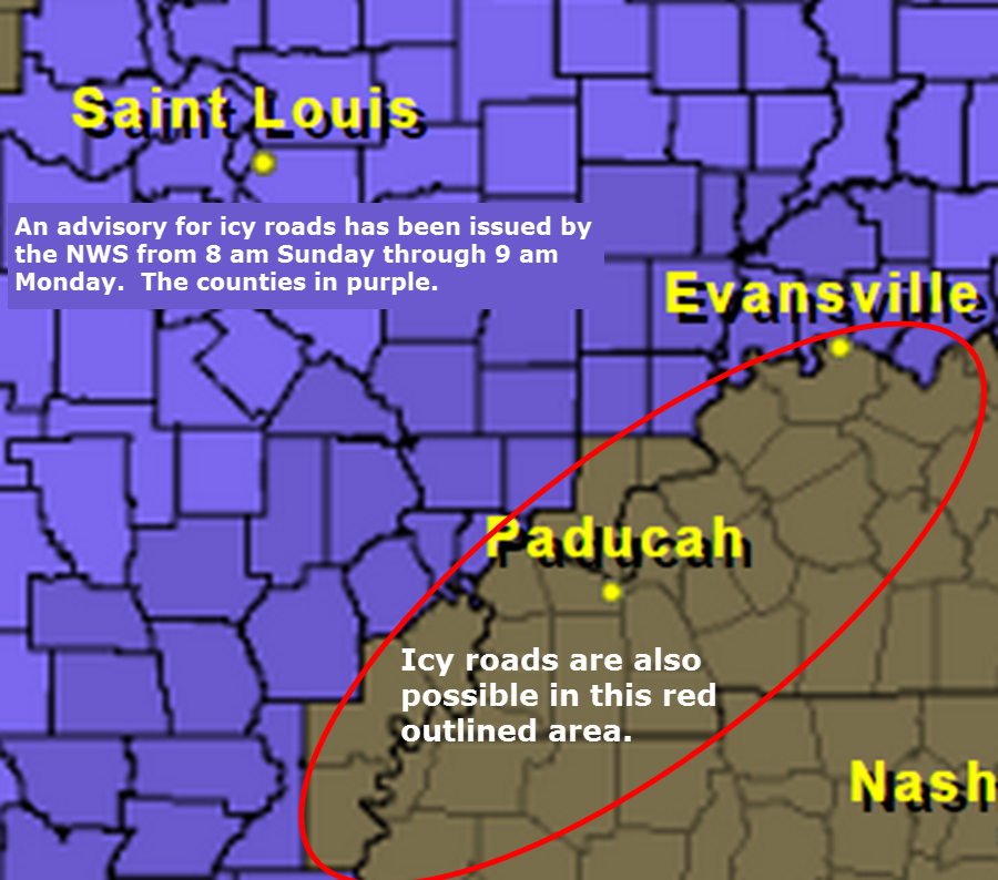
Precipitation should start tomorrow morning over southeast Missouri and spread into southern Illinois and western Kentucky by late morning and into the afternoon hours. Ice accumulation on trees, power lines, and roadways should be in the 0.10″ to 0.20″ range across the coldest areas (likely the counties in purple).
You can read the text of the travelers advisory for freezing rain by clicking here and then clicking on your particular county.
A longer Facebook thread here
Previous updates below…
We have our first sponsor for the blog. Milner and Orr Funeral Home and Cremation Services located in Paducah, Kentucky and three other western Kentucky towns – at Milner and Orr they believe in families helping families.
![]()

This forecast update covers far southern Illinois, far southeast Missouri, and far western Kentucky. See the coverage map on the right side of the blog.
I will try and update the blog a couple of times today.
Saturday – Mostly sunny. Perhaps some high clouds in the afternoon. Chilly. High temperatures only in the 20’s. Winds becoming southerly at 5-10 mph.
Saturday night – Becoming cloudy. Low temperatures in the lower 20’s. Southerly winds at 5-10 mph.
Sunday – Cloudy with sleet and freezing rain developing. Precipitation may develop during the morning hours, but it is more likely as the afternoon wears on. Precipitation will change to all rain in areas where the temperature rises above 32 degrees this would most likely occur over west KY and far far southern IL). High temperatures only in the 30’s. South winds at 10 mph. Some travel problems are possible. See the winter storm discussion part of the blog below
Sunday night – A wintry mix for parts of southeast Missouri and southern Illinois. Mostly rain for the Missouri Bootheel and western Kentucky. Low temperatures in the lower 30’s. South winds at 5-10 mph. Winds may turn out of the north late at night.
Monday – Whatever precipitation is left over will come to an end on Monday morning. It will be cold with high temperatures only in the 30’s. Falling temperatures into the 20’s during the afternoon hours. North winds at 10-20 mph. These winds will make it feel colder. Wind chills during the morning hours will be in the upper teens and lower 20’s. Wind chills by evening will be in the single digits to lower teens.
MEDIUM CONFIDENCE in this forecast…

Current Temperatures Around The Local Area


An explanation of what is happening in the atmosphere over the coming days.
Weather Headlines
1. Chilly start to your Saturday
2. Precipitation arrives on Sunday into Monday morning
3. Rain over some of our counties
4. Wintry mix of freezing rain and sleet over other parts of the area.
5. Some travel problems are possible over some of our counties Sunday into Monday
Note from this Facebook post that I am looking for sponsors and donors to keep the weather information flowing. Read more about that click here.
Welcome to the weekend! Did you stay warm last night? Most areas dipped into the single digits (very close to it for those who did not).
The good news is that we will not see thermometers return to single digits tonight! Collective cheer? I can almost hear you. The bad news is that it will remain cold for the coming days and we have to deal with a precipitation event on Sunday afternoon into Sunday night/Monday morning.
Even at this late hour, questions remain as to what type of precipitation will fall, what time precipitation will start, and what time precipitation will come to an end. This is not an easy forecast. Are they ever?
Temperatures today will rise into the 20’s. We should see quite a bit of sun. Clouds may increase this afternoon as our weather system starts to take shape to our south and southwest. We will not have to deal with precipitation today.
Clouds increase quickly tonight in response to a southwest and southerly wind flow. Moisture will start to spread back into our region from the southwest. Slowly, but surely. By Sunday morning we may already start to see some radar returns over northern Arkansas and southern Missouri.
Sunday into Monday will bring the brunt of the precipitation event
What is important to remember is that road temperatures are very cold. It will only take a tiny bit of freezing rain to cause dangerous travel conditions. This is especially true of untreated roadways.
See the winter storm forecast part of the WeatherTalk blog update for more information and some graphics (below)
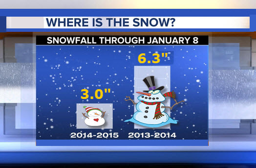
Let’s compare last years snow to this years snow

Shifted the 32 degree line a bit further south and east (see maps below)

All of my attention is centered on the winter storm discussion part of this update (see below). A wintry mix of freezing rain and sleet could cause some problems on Sunday afternoon into Monday morning. Concerns will be on slick roadways for some of us.
What is important to remember is that road temperatures are very cold. It will only take a tiny bit of freezing rain to cause dangerous travel conditions. This is especially true of untreated roadways.

The wild card tells you where the most uncertainty is in the current forecast.
Wild card in this forecast – this is an easy one! The wild card centers around the placement of the freezing rain (ice) line vs the rain line. Going to be a nail biter. Who ends up with ice vs rain.

Will I need to take action?
Anyone with travel plans Sunday into Monday should monitor the latest forecast. You may need to change your travel plans if freezing rain and sleet develops.
What is important to remember is that road temperatures are very cold. It will only take a tiny bit of freezing rain to cause dangerous travel conditions. This is especially true of untreated roadways.
This is especially true if you are heading to places like Carbondale, Marion, or Mt Vernon, Illinois. If you are heading to St Louis, Missouri. You will want to check the latest forecast and road conditions. A light wintry mix will be possible.

How much rain should this system produce over our region?
There is a lot of discussion on how much precipitation is going to fall with this system. Right now I am thinking most areas pick up 0.25″ – 0.50″ of precipitation. It is possible that parts of western Kentucky will pick up a bit more. But, let’s go with that as a general forecast idea.
Now, that 0.25″-0.50″ is liquid. If that falls as sleet then you might expect a dusting of sleet (perhaps a bit more). If that falls as freezing rain then some counties could pick up 0.10″ to 0.20″ of freezing rain. The Missouri Ozarks might stay below freezing through this entire event. If that occurs then they would have the most freezing rain accumulation.
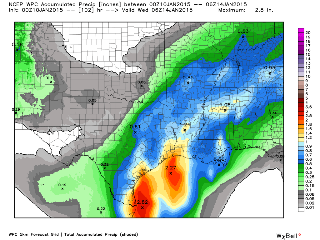
Here is the latest WPC (Weather Prediction Center) precipitation forecast. They will update this map later this morning.
You can see the blue and light blue areas over parts of far southeast Missouri, far southern Illinois, and western Kentucky. That would be 0.50 to 0.90″ of mostly rain. That is a bit higher than what I have in my forecast. I was going with 0.25″-0.50″ for the region. But, again – there could be a bit more than that over parts of far southern Illinois and western Kentucky. The Missouri Bootheel, as well.
We have a new sponsor! G&C Multi-Services out of Paducah, Kentucky. G & C Multi-Services is a service provider in Western Kentucky that provides industrial and commercial equipment fabrication, machine troubleshooting, repair and maintenance, and installation. They can custom fabricate steel, stainless, and aluminum products per customer specifications.
Visit their web-site here. Or click the ad below! They have a Facebook page and it can be viewed here.


Concerns for the upcoming days…
1. Wintry mix and rain arrives on Sunday
2. Timing is still in question.
3. Very unsure on exactly where the 32° line should be placed during Sunday afternoon into Monday morning.
4. Some hazardous travel conditions are possible over at least portions of the area
5. If this system remains all freezing rain (for parts of the area) then some accumulation of ice can be expected on trees and other surfaces.
CONFIDENCE IS LOW on this part of the forecast. This is mainly because I don’t have a lot of confidence on where to place the freezing line. It is going to be a tricky forecast right up until the event arrives.
If you have travel plans on Sunday afternoon into Monday morning then you will want to monitor the latest updates.
What is important to remember, as well, is that road temperatures are very cold. It will only take a tiny bit of freezing rain to cause dangerous travel conditions.
Over the last 24 hours there has been a movement towards general agreement on how Sunday into Monday morning will unfold across our region.
A mixture of rain, freezing rain, and sleet will develop over Arkansas and southern Missouri on Sunday morning. This precipitation will spread into our area late Sunday morning into the afternoon hours. The exact timing may still need to be fine tuned as we move forward. Typically models do not handle these type of events very well. Precipitation usually breaks out a bit earlier than the models would indicate.
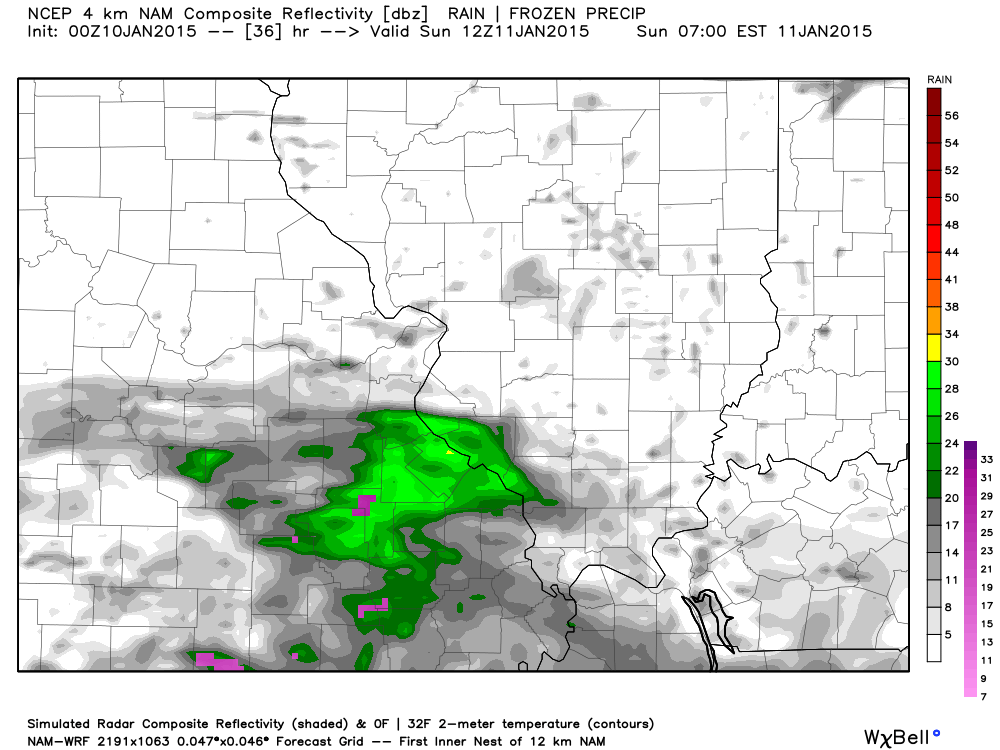
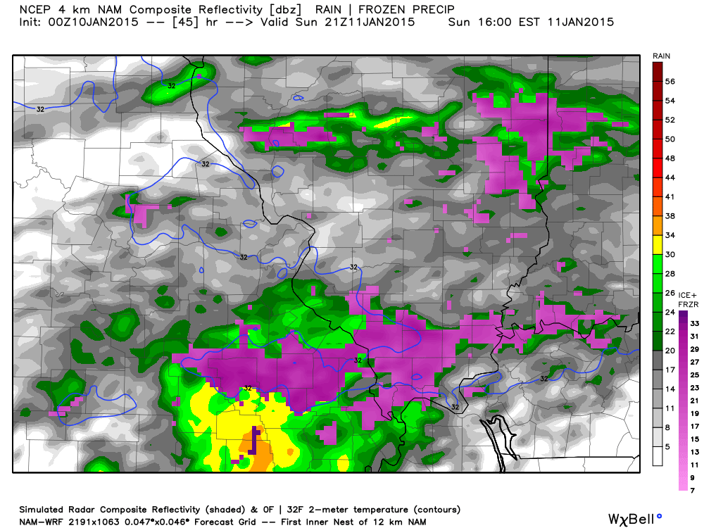
Here is the NAM WRF future-cast radar for Sunday morning and early afternoon. You can see precipitation spreading into parts of our region as early as 6 or 7 am
If precipitation does move into our counties during the early morning hours then it would likely be frozen. www.weatherbell.com images.
Here is the NAM weather model for around 3 pm. Precipitation becomes more widespread.
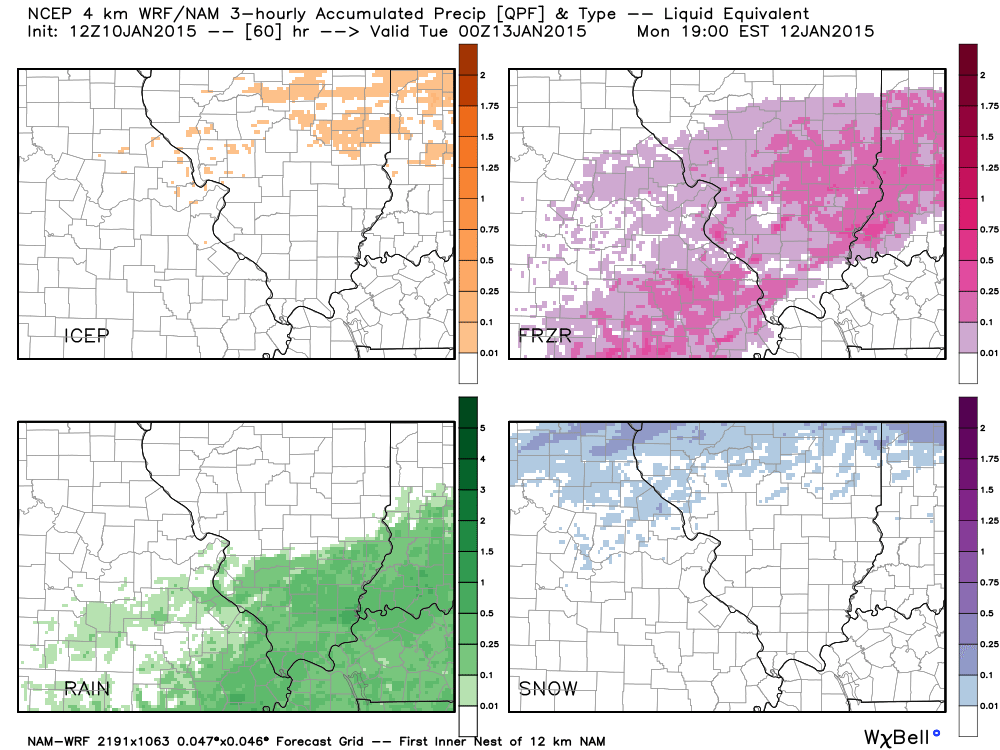
The purple is a wintry mix.
Temperatures may not rise above freezing across parts of southeast Missouri and southern Illinois through this precipitation event. If that is the case then some areas will receive freezing rain and sleet with no changeover to rain. Exactly where to draw the freezing line has been the question over the last few days. That remains the question in this update.
For now, I am drawing a line from just west of Poplar Bluff, Missouri towards Grand Tower, Illinois and then towards Mt Vernon, Illinois. This is the most likely area that will stay all frozen precipitation.
This COULD change in future updates. I will likely update the blog this morning and again this evening.
This is the 8 am update map – I have shifted the line just a bit further south. Very tough call.
It should be within one or two counties of this line.
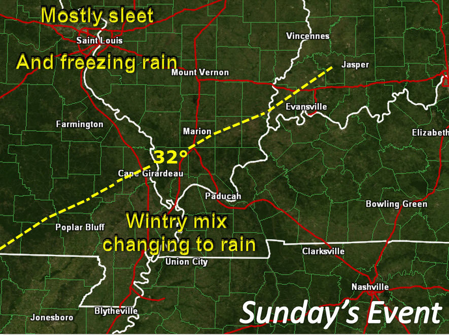
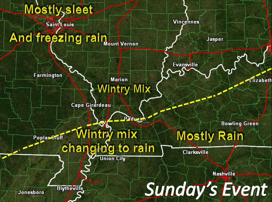
Areas just south of that yellow line should see a wintry mix changing over to rain
There are concerns about this forecast…confidence is lower than normal as to how this plays out.
Almost all of the data is showing temperatures within 1-3 degrees of freezing across most of southeast Missouri, much of southern Illinois, and along the Ohio River in western Kentucky. If this forecast is off by a couple of degrees then it could mean a larger area dealing with freezing rain and sleet.
If that were the case then the above map would look more like this
I do have some confidence that areas along the KY/TN line will be mostly rain. Areas over towards Bowling Green, as well. Mostly rain there.
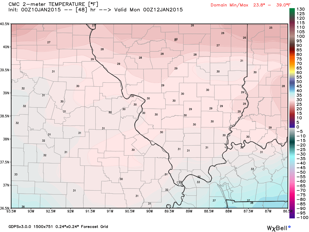
Let me show you how tricky this is. This is the Canadian weather model. These are Sunday evening temperatures. See those 31 and 32 degree readings? Very tough call on temperatures.
Good luck forecasting whether your town will be 31 degrees or 33 degrees. Much easier as you go south in the area. Areas along the KY/TN border will be mostly rain. Temperatures should be well above freezing in those areas.
Click image for a larger view. This is for 6 pm on Sunday evening.
Here is the Saturday morning updated high resolution WRF model. It breaks down the precipitation into types. The top left is sleet, the top right is freezing rain, the bottom left is rain, and the bottom right is snow.
It is drawing the rain/ice line very close to where I have drawn the 32 degree line.
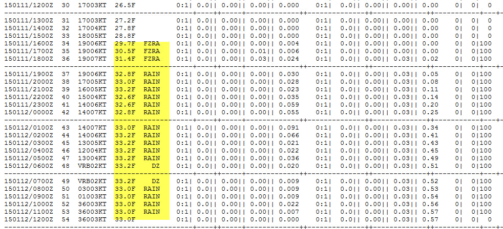
Check out this model data for Vienna, IL. Want to see just how tricky this is. I highlighted the temp and precip type. This is within 1 or 2 degrees of freezing. VERY hard to get the forecast right with temps like this.

A southern system could spread a little bit of light snow into our area around Wednesday or Thursday. Right now it looks like most of that will stay to our south. It is worth monitoring in case the track of the storm changes.
For now, my focus is on the Sunday/Monday event.

We have regional radars and local city radars – if a radar does not seem to be updating then try another one. Occasional browsers need their cache cleared. You may also try restarting your browser. That usually fixes the problem. Occasionally we do have a radar go down. That is why I have duplicates. Thus, if one fails then try another one.
If you have any problems then please send me an email beaudodson@usawx.com
WEATHER RADAR PAGE – Click here —
We also have a new national interactive radar – you can view that radar by clicking here.
Local interactive city radars include St Louis, Mt Vernon, Evansville, Poplar Bluff, Cape Girardeau, Marion, Paducah, Hopkinsville, Memphis, Nashville, Dyersburg, and all of eastern Kentucky – these are interactive radars. Local city radars – click here
NOTE: Occasionally you will see ground clutter on the radar (these are false echoes). Normally they show up close to the radar sites – including Paducah.

Regional Radar – Click on radar to take you our full radar page.


Regional Radar
![]()
Current WARNINGS (a warning means take action now). Click on your county to drill down to the latest warning information. Keep in mind that there can be a 2-3 minute delay in the updated warning information.
I strongly encourage you to use a NOAA Weather Radio or warning cell phone app for the most up to date warning information. Nothing is faster than a NOAA weather radio.


Color shaded counties are under some type of watch, warning, advisory, or special weather statement. Click your county to view the latest information.

Missouri Warnings

Illinois Warnings

Kentucky Warnings

Please visit your local National Weather Service Office by clicking here. The National Weather Service Office, for our region, is located in Paducah, Kentucky.

Here is the official 6-10 day and 8-14 day temperature and precipitation outlook. Check the date stamp at the top of each image (so you understand the time frame).
The forecast maps below are issued by the Weather Prediction Center (NOAA).


The latest 8-14 day temperature and precipitation outlook. Note the dates are at the top of the image. These maps DO NOT tell you how high or low temperatures or precipitation will be. They simply give you the probability as to whether temperatures or precipitation will be above or below normal.


Many of my graphics are from www.weatherbell.com – a great resource for weather data, model data, and more


This blog was inspired by ABC 33/40’s Alabama Weather Blog – view their blog
Current tower cam view from the Weather Observatory- Click here for all cameras.

Southern Illinois Weather Observatory

The Weather Observatory

Southern Illinois Weather Observatory
WSIL TV 3 has a number of tower cameras. Click here for their tower camera page & Illinois Road Conditions

Marion, Illinois
WPSD TV 6 has a number of tower cameras. Click here for their tower camera page & Kentucky Road Conditions & Kentucky Highway and Interstate Cameras

Downtown Paducah, Kentucky
Benton, Kentucky Tower Camera – Click here for full view

Benton, Kentucky

I24 Paducah, Kentucky

I24 Mile Point 9 – Paducah, KY

I24 – Mile Point 3 Paducah, Kentucky

You can sign up for my AWARE email by clicking here I typically send out AWARE emails before severe weather, winter storms, or other active weather situations. I do not email watches or warnings. The emails are a basic “heads up” concerning incoming weather conditions.