We have some great sponsors for the Weather Talk Blog. Please let our sponsors know that you appreciate their support for the Weather Talk Blog.
Milner and Orr Funeral Home and Cremation Services located in Paducah, Kentucky and three other western Kentucky towns – at Milner and Orr they believe in families helping families. You can find Milner and Orr on Facebook, as well.
![]()
.

Wortham Dental Care located in Paducah, Kentucky. The gentle dentist. Mercury free dentistry. They also do safe Mercury removal. You can find Wortham Dental Care on Facebook, as well
.

For all of your families eye care needs. Visit their web-site here. Or, you can also visit their Facebook page.
.

Endrizzi’s Storm Shelters – For more information click here. Endrizzi Contracting and Landscaping can be found on Facebook, as well – click here
.

Best at Enabling Body Shop Profitability since 1996. Located In Paducah Kentucky and Evansville Indiana; serving all customers in between. They provide Customer Service, along with all the tools necessary for body shops to remain educated and competitive. Click the logo above for their main web-site. You can find McClintock Preferred Finishes on Facebook, as well
.

Duck/goose decoys? Game calls? Optics? We have you covered! Click the logo above or visit Final Flight on Facebook, as well.
.
.
I have launched the new weather texting service! I could use your help. Be sure and sign up and fully support all of the weather data you see each day.
This is a monthly subscription service. Supporting this helps support everything else. The cost is $3 a month for one phone, $5 a month for three phones, and $10 a month for seven phones.
For more information visit BeauDodsonWeather.com
Or directly sign up at Weathertalk.com


This forecast update covers far southern Illinois, far southeast Missouri, and far western Kentucky. See the coverage map on the right side of the blog.
Remember that weather evolves. Check back frequently for updates, especially during active weather.
Click Here For River Stage Forecasts…
Avoid flooded roadways!
.
Tuesday night – Mostly clear and cold.
Temperatures: Lows in the 24 to 28 degree range
Winds: East/southeast winds at 4-8 mph.
What is the chance for precipitation? 0%
Coverage of precipitation? None
My confidence in this part of the forecast verifying is High
Should I be concerned about snow or ice? No
Should I cancel my outdoor plans? No
Is severe weather expected? No
What impact is expected? Rivers and streams will continue to run high. Avoid flooded roadways.
Wednesday – Periods of clouds. Cool.
Temperatures: Highs in the 38 to 44 degree range.
Winds: Southeast/south winds at 5-10 mph with afternoon gusts above 15 mph.
What is the chance for precipitation? 0%
Coverage of precipitation? None
My confidence in this part of the forecast verifying is High
Should I be concerned about snow or ice? No
Should I cancel my outdoor plans? No
Is severe weather expected? No
What impact is expected? Rivers and streams will continue to run high. Avoid flooded roadways.
Wednesday night – Becoming cloudy.
Temperatures: Lows in the 30 to 36 degree range
Winds: Southeast winds at 4-8 mph. Gusts to 12 mph.
What is the chance for precipitation? 10%
Coverage of precipitation? Isolated
My confidence in this part of the forecast verifying is High
Should I be concerned about snow or ice? No
Should I cancel my outdoor plans? No
Is severe weather expected? No
What impact is expected? Rivers and streams will continue to run high. Avoid flooded roadways.
Thursday – Cloudy. A chance for showers. Showers more likely in the afternoon.
Temperatures: Highs in the 45 to 50 degree range.
Winds: Southeast winds at 4-8 mph.
What is the chance for precipitation? 30% before noon and 40%-60% after noon
Coverage of precipitation? Scattered early and then becoming more widespread in the afternoon.
My confidence in this part of the forecast verifying is High
Should I be concerned about snow or ice? No
Should I cancel my outdoor plans? Some rain will be possible.
Is severe weather expected? No
What impact is expected? Wet roadways. Rivers and streams will continue to run high. Avoid flooded roadways.
Thursday night – Some showers likely.
Temperatures: Lows in the 36 to 43 degree range
Winds: Southeast winds at 6-12 mph. Gusts to 15 mph.
What is the chance for precipitation? 80%
Coverage of precipitation? Widespread
My confidence in this part of the forecast verifying is High
Should I be concerned about snow or ice? No
Should I cancel my outdoor plans? Yes, have a plan B
Is severe weather expected? No
What impact is expected? Wet roadways. Rivers and streams will continue to run high. Avoid flooded roadways.
Friday – Cloudy. A chance for showers, mainly during the morning hours.
Temperatures: Highs in the lower to middle 50s.
Winds: Southwest winds at 6-12 mph with gusts to 20 mph.
What is the chance for precipitation? 40%
Coverage of precipitation? Scattered early in the day
My confidence in this part of the forecast verifying is Medium
Should I be concerned about snow or ice? No
Should I cancel my outdoor plans? Some rain will be possible early in the day.
Is severe weather expected? No
What impact is expected? Wet roadways. Rivers and streams will continue to run high. Avoid flooded roadways.
Friday night – Some showers likely.
Temperatures: Lows in the 40-46 degree range
Winds: South winds at 6-12 mph.
What is the chance for precipitation? 40%
Coverage of precipitation? Scattered
My confidence in this part of the forecast verifying is Medium
Should I be concerned about snow or ice? No
Should I cancel my outdoor plans? Small chance for evening rain. Rain chances go up as you move later into the night.
Is severe weather expected? No
What impact is expected? Wet roadways. Rivers and streams will continue to run high. Avoid flooded roadways.
Saturday – Cloudy. A good chance for showers. Maybe a rumble of thunder.
Temperatures: Highs in the upper 40s to lower 50s.
Winds: South winds at 6-12 mph. Winds becoming north/northwest.
What is the chance for precipitation? 60%
Coverage of precipitation? Widespread
My confidence in this part of the forecast verifying is Medium
Should I be concerned about snow or ice? No
Should I cancel my outdoor plans? Some rain will be possible.
Is severe weather expected? No
What impact is expected? Wet roadways possible. Perhaps some lightning. Rivers and streams will continue to run high. Avoid flooded roadways.
Saturday night – A chance for showers. Turning colder from northwest to southeast.
Temperatures: Lows in the 30 to 36 degree range. Temperatures may vary a bit on Saturday night as a cold front moves through the area.
Winds: Northwest winds at 7-14 mph.
What is the chance for precipitation? 40%
Coverage of precipitation? Scattered
My confidence in this part of the forecast verifying is Medium
Should I be concerned about snow or ice? No
Should I cancel my outdoor plans? Some showers possible. Perhaps ending as a flurry or sleet pellet.
Is severe weather expected? No
What impact is expected? If the cold air moves in quick enough then there could be a few slick spots if a little moisture remains on roadways.
Sunday – Mix of sun and clouds. Can’t rule out a flurry. Cold.
Temperatures: Highs in the 30s, but falling into the 20s
Winds: Northwest wind 10-15 mph.
What is the chance for precipitation? 20%
Coverage of precipitation? Isolated
My confidence in this part of the forecast verifying is Medium
Should I be concerned about snow or ice? Small chance for a brief period of a wintry mix. Not expecting any accumulation, at this time.
Should I cancel my outdoor plans? It will be turning quite cold on Sunday with low wind chills possible.
Is severe weather expected? No
What impact is expected? If the cold air moves in quick enough then there could be a few slick spots if a little moisture remains on roadways.


Don’t forget to check out the Southern Illinois Weather Observatory web-site for weather maps, tower cams, scanner feeds, radars, and much more! Click here

An explanation of what is happening in the atmosphere over the coming days…
Highlights
1. Rivers have crested and will continue to fall
2. Chilly weather into Wednesday
3. Rain chances increase on Thursday and Friday
4. Cold wave next week
Wednesday will deliver another quiet day of weather to the region. Cool temperatures, but nothing extreme. We should see some increase in clouds on Wednesday, as well. This will be indications of a change in our weather pattern.
Weather changes are already showing up on the weather map as we push into Wednesday night and Thursday. An area of low pressure will take shape over Oklahoma and Kansas on Thursday. This low will travel northeast into Missouri, Iowa, and northern Illinois. A cold front will accompany the area of low pressure. This all spells rain for our local area.
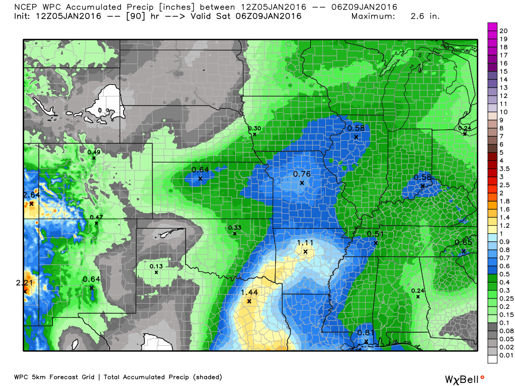
Rainfall totals from this system won’t be all that impressive. Perhaps 0.30″-0.60″. A few spots could have a little more than that. But, overall this appears to be a light rain event. These rainfall totals will not cause additional rises on the rivers. That is the good news.
Several disturbances will move through our region over the weekend into early next week. I can’t rule out some additional showers with each one of these. Both Saturday and Sunday should be cloudy. And, perhaps some light precipitation. We will need to track the falling temperatures in relation to the placement of precipitation.
Much colder air arrives on Sunday into next week. If one of these disturbances were stronger then we would be thinking about snow. But, for now, it appears they won’t be all that organized. As always, trends need to be monitored.
Occasionally temperatures fall quickly behind these cold fronts. And, if moisture is left on roadways then that could cause some slick spots. This will need to be monitored.
Temperatures by Monday morning will dip into the teens, once again.
Some charts
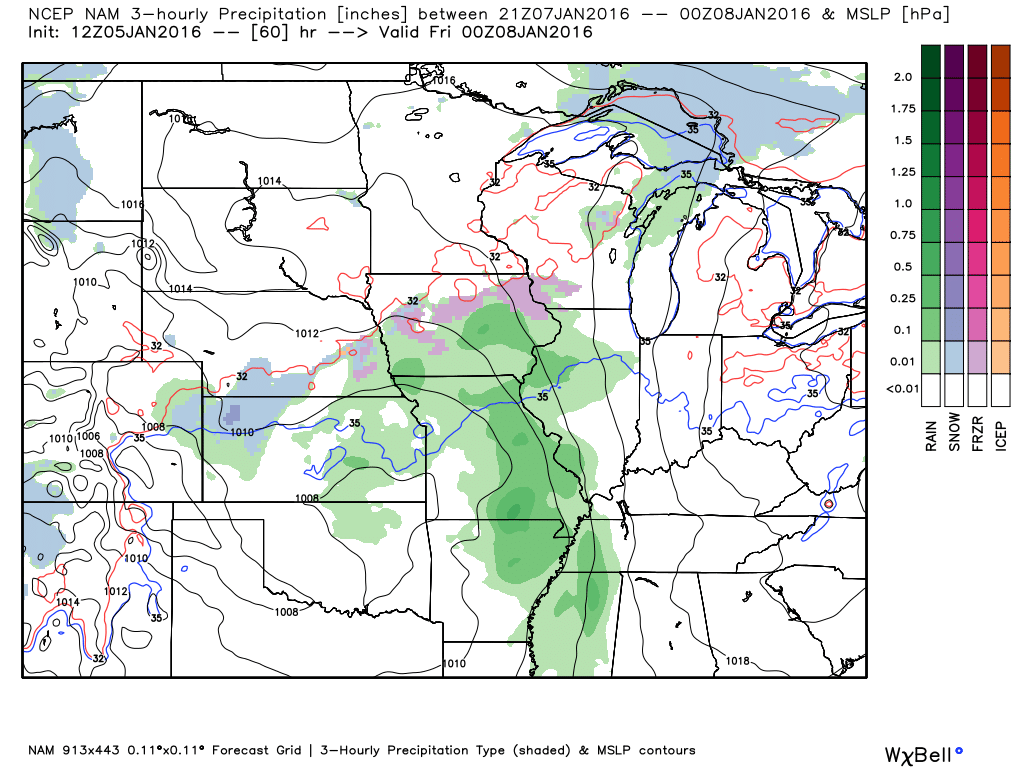
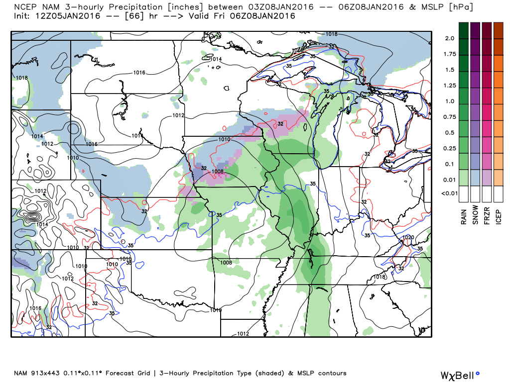
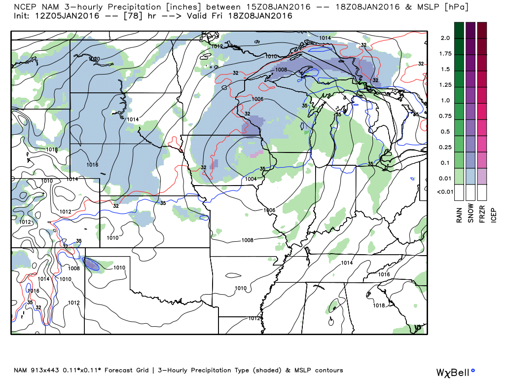
This is the NAM model guidance. The green represents rain. These maps are from weatherbell.com
This first map is for Thursday evening at 6 pm. This map shows you the rainfall totals between 3 pm and 6 pm.
This next map is for the rainfall totals between 8 pm and 11 pm on Thursday night
This next map is for Friday. You can see the rain is on the way out.
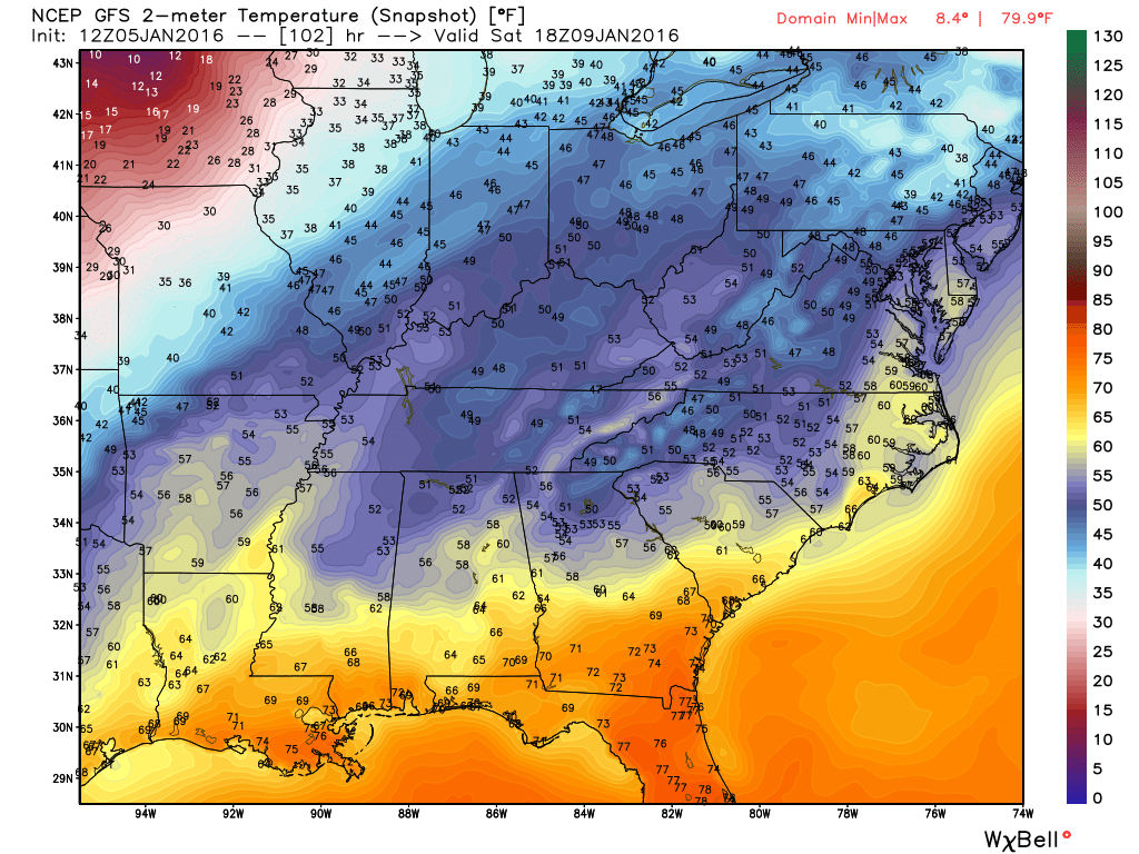
Let’s take a look at some temperature maps.
This first map is for Saturday. You can see the blue and yellow colors in our region. Those colors represents 40s and maybe some lower 50s. Click the map for a larger view.
Then, moving ahead to Sunday evening. You can see temperatures are quite a bit colder. Mostly in the 20s by Sunday afternoon and evening. Brrrr weather.
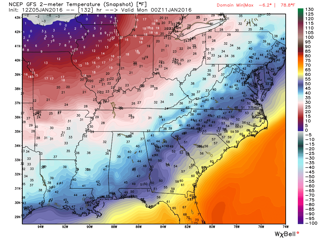
Finally, let’s look at Monday morning temperatures. Widespread teens in our area. Some below zero readings over Iowa and Wisconsin.
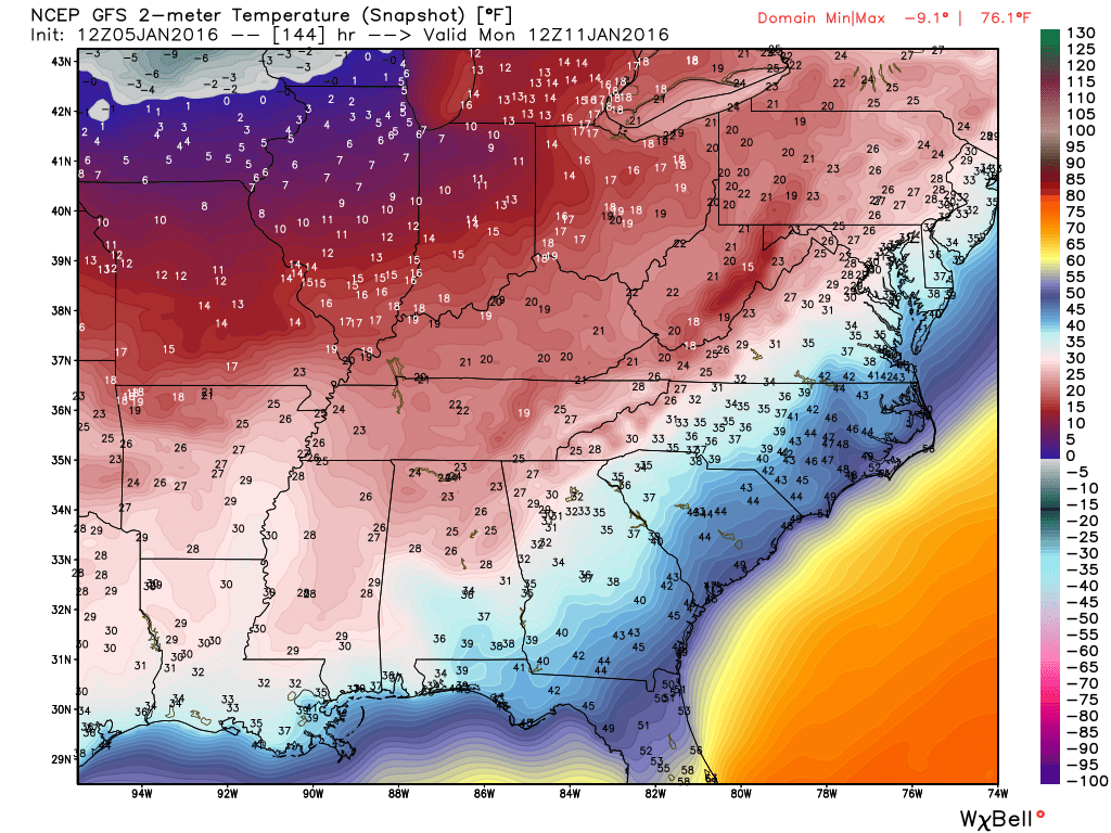
Zoomed in on the Monday morning temperatures. Could be a bit colder than this if the clouds clear out.


Here are the current river stage forecasts. You can click your state and then the dot for your location. It will bring up the full forecast and hydrograph.
Click Here For River Stage Forecasts…
Here are some current forecast hydrographs. These will be updated each day with new information.


Smithland Lock and Dam

Paducah, Kentucky Forecast Stage

Cairo, Illinois

Cape Girardeau, Missouri
Clickable map


Here are the current river stage forecasts. You can click your state and then the dot for your location. It will bring up the full forecast and hydrograph.
Click Here For River Stage Forecasts…

No snow anticipated.

Wednesday – No snow or ice anticipated.
Wednesday night – No snow or ice anticipated.
Thursday – No snow or ice anticipated.
Friday – No snow or ice anticipated.
Saturday – No snow or ice anticipated.
Sunday – Small chance for a little wintry mix as colder temperatures arrive. At this time, this does not appear to be a big deal. However, let’s keep an eye on it.

Increased cloud cover on Wednesday. Otherwise, no significant changes.

River flooding continues to be the main concern.
Monitor the latest crest forecast numbers.
Avoid flooded roadways.
Watching Saturday night and Sunday as colder air arrives. If precipitation remains then there could be a light wintry mix. Low confidence.

Rivers have crested. But, they still remain high.
Avoid flooded roadways.

The wild card for this update will be rainfall totals on Thursday and Friday. This appears to be an event that would produce 0.40″-0.60″. Some data indicates amounts greater than 0.60″. So, the wild card will be whether rainfall totals will exceed that amount.
The second wild card will be the weekend forecast. Data indicates a bit of light rain on Saturday and Sunday. We will need to track the cold air. If the cold air moves in quick enough then perhaps a light wintry mix on Sunday before precipitation ends. Low confidence, at this point.

How much precipitation should we expect over the next few days?
Watching Thursday and Friday for some rain chances.
Here are the expected rainfall totals for the Thursday/Friday system. This is the WPC map. Image is from weatherbell.com and you can click the image for a larger view

Can we expect severe thunderstorms over the next 24 to 48 hours? Remember that a severe thunderstorm is defined as a thunderstorm that produces 58 mph winds or higher, quarter size hail or larger, and/or a tornado.
The thunderstorm threat level will be a ZERO for the next seven day.
.
No risk of severe weather through the rest of this week.

We have regional radars and local city radars – if a radar does not seem to be updating then try another one. Occasional browsers need their cache cleared. You may also try restarting your browser. That usually fixes the problem. Occasionally we do have a radar go down. That is why I have duplicates. Thus, if one fails then try another one.
If you have any problems then please send me an email beaudodson@usawx.com
WEATHER RADAR PAGE – Click here —
We also have a new national interactive radar – you can view that radar by clicking here.
Local interactive city radars include St Louis, Mt Vernon, Evansville, Poplar Bluff, Cape Girardeau, Marion, Paducah, Hopkinsville, Memphis, Nashville, Dyersburg, and all of eastern Kentucky – these are interactive radars. Local city radars – click here
NOTE: Occasionally you will see ground clutter on the radar (these are false echoes). Normally they show up close to the radar sites – including Paducah.


Here is the official 6-10 day and 8-14 day temperature and precipitation outlook. Check the date stamp at the top of each image (so you understand the time frame).
The forecast maps below are issued by the Weather Prediction Center (NOAA).


The latest 8-14 day temperature and precipitation outlook. Note the dates are at the top of the image. These maps DO NOT tell you how high or low temperatures or precipitation will be. They simply give you the probability as to whether temperatures or precipitation will be above or below normal.


Here are the current river stage forecasts. You can click your state and then the dot for your location. It will bring up the full forecast and hydrograph.
Click Here For River Stage Forecasts…

Who do you trust for your weather information and who holds them accountable?
I have studied weather in our region since the late 1970’s. I have 37 years of experience in observing our regions weather patterns. My degree is in Broadcast Meteorology from Mississippi State University and an Associate of Science (AS). I am currently working on my Bachelor’s Degree in Geoscience.
My resume includes:
Member of the American Meteorological Society.
NOAA Weather-Ready Nation Ambassador.
Meteorologist for McCracken County Emergency Management. I served from 2005 through 2015.
I own and operate the Southern Illinois Weather Observatory.
Recipient of the Mark Trail Award, WPSD Six Who Make A Difference Award, Kentucky Colonel, and the Caesar J. Fiamma” Award from the American Red Cross.
In 2009 I was presented with the Kentucky Office of Highway Safety Award.
Recognized by the Kentucky House of Representatives for my service to the State of Kentucky leading up to several winter storms and severe weather outbreaks.
I am also President of the Shadow Angel Foundation which serves portions of western Kentucky and southern Illinois.
There is a lot of noise on the internet. A lot of weather maps are posted without explanation. Over time you should learn who to trust for your weather information.
My forecast philosophy is simple and straight forward.
- Communicate in simple terms
- To be as accurate as possible within a reasonable time frame before an event
- Interact with you on Twitter, Facebook, and the blog
- Minimize the “hype” that you might see on television or through other weather sources
- Push you towards utilizing wall-to-wall LOCAL TV coverage during severe weather events
I am a recipient of the Mark Trail Award, WPSD Six Who Make A Difference Award, Kentucky Colonel, and the Caesar J. Fiamma” Award from the American Red Cross. In 2009 I was presented with the Kentucky Office of Highway Safety Award. I was recognized by the Kentucky House of Representatives for my service to the State of Kentucky leading up to several winter storms and severe weather outbreaks.
If you click on the image below you can read the Kentucky House of Representatives Resolution.

Many of my graphics are from www.weatherbell.com – a great resource for weather data, model data, and more


You can sign up for my AWARE email by clicking here I typically send out AWARE emails before severe weather, winter storms, or other active weather situations. I do not email watches or warnings. The emails are a basic “heads up” concerning incoming weather conditions.