We have some great sponsors for the Weather Talk Blog. Please let our sponsors know that you appreciate their support for the Weather Talk Blog.
Milner and Orr Funeral Home and Cremation Services located in Paducah, Kentucky and three other western Kentucky towns – at Milner and Orr they believe in families helping families. You can find Milner and Orr on Facebook, as well.
![]()
.

Wortham Dental Care located in Paducah, Kentucky. The gentle dentist. Mercury free dentistry. They also do safe Mercury removal. You can find Wortham Dental Care on Facebook, as well
.

For all of your families eye care needs. Visit their web-site here. Or, you can also visit their Facebook page.
.

Endrizzi’s Storm Shelters – For more information click here. Endrizzi Contracting and Landscaping can be found on Facebook, as well – click here
.

Best at Enabling Body Shop Profitability since 1996. Located In Paducah Kentucky and Evansville Indiana; serving all customers in between. They provide Customer Service, along with all the tools necessary for body shops to remain educated and competitive. Click the logo above for their main web-site. You can find McClintock Preferred Finishes on Facebook, as well
.

Duck/goose decoys? Game calls? Optics? We have you covered! Click the logo above or visit Final Flight on Facebook, as well.
.
.
I have launched the new weather texting service! I could use your help. Be sure and sign up and fully support all of the weather data you see each day.
This is a monthly subscription service. Supporting this helps support everything else. The cost is $3 a month for one phone, $5 a month for three phones, and $10 a month for seven phones.
For more information visit BeauDodsonWeather.com
Or directly sign up at Weathertalk.com


This forecast update covers far southern Illinois, far southeast Missouri, and far western Kentucky. See the coverage map on the right side of the blog.
Remember that weather evolves. Check back frequently for updates, especially during active weather.
Click Here For River Stage Forecasts…
Avoid flooded roadways!
.
Monday night – Mostly clear and chilly.
Temperatures: Lows in the 16-24 degree range
Winds: Northeast winds at 4-8 mph.
What is the chance for precipitation? 0%
Coverage of precipitation? None
My confidence in this part of the forecast verifying is High
Should I be concerned about snow or ice? No
Should I cancel my outdoor plans? No
Is severe weather expected? No
What impact is expected? Rivers and streams will continue to run high. Avoid flooded roadways.
Tuesday – Mostly sunny and chilly.
Temperatures: Highs in the 35 to 40 degree range.
Winds: East winds at 5 mph.
What is the chance for precipitation? 0%
Coverage of precipitation? None
My confidence in this part of the forecast verifying is High
Should I be concerned about snow or ice? No
Should I cancel my outdoor plans? No
Is severe weather expected? No
What impact is expected? Rivers and streams will continue to run high. Avoid flooded roadways.
Tuesday night – Mostly clear and cold.
Temperatures: Lows in the 24 to 28 degree range
Winds: East/southeast winds at 4-8 mph.
What is the chance for precipitation? 0%
Coverage of precipitation? None
My confidence in this part of the forecast verifying is High
Should I be concerned about snow or ice? No
Should I cancel my outdoor plans? No
Is severe weather expected? No
What impact is expected? Rivers and streams will continue to run high. Avoid flooded roadways.
Wednesday – Perhaps some increase in clouds during the afternoon. Cold.
Temperatures: Highs in the 38 to 44 degree range.
Winds: Southeast/south winds at 4-8 mph.
What is the chance for precipitation? 0%
Coverage of precipitation? None
My confidence in this part of the forecast verifying is High
Should I be concerned about snow or ice? No
Should I cancel my outdoor plans? No
Is severe weather expected? No
What impact is expected? Rivers and streams will continue to run high. Avoid flooded roadways.
Wednesday night – Becoming cloudy.
Temperatures: Lows in the 30 to 36 degree range
Winds: Southeast winds at 4-8 mph.
What is the chance for precipitation? 10%
Coverage of precipitation? None
My confidence in this part of the forecast verifying is High
Should I be concerned about snow or ice? No
Should I cancel my outdoor plans? No
Is severe weather expected? No
What impact is expected? Rivers and streams will continue to run high. Avoid flooded roadways.
Thursday – Cloudy. A chance for showers.
Temperatures: Highs in the 42 to 48 degree range.
Winds: Southeast winds at 4-8 mph.
What is the chance for precipitation? 40%
Coverage of precipitation? Scattered
My confidence in this part of the forecast verifying is High
Should I be concerned about snow or ice? No
Should I cancel my outdoor plans? Some rain will be possible.
Is severe weather expected? No
What impact is expected? Wet roadways. Rivers and streams will continue to run high. Avoid flooded roadways.
Rain likely Thursday night into Friday. Maybe a few more showers with a second cold front on Saturday night or Sunday.


Don’t forget to check out the Southern Illinois Weather Observatory web-site for weather maps, tower cams, scanner feeds, radars, and much more! Click here

An explanation of what is happening in the atmosphere over the coming days…
Highlights
1. Rivers have crested and will continue to fall
2. Chilly weather into Wednesday
3. Rain chances increase on Thursday and Friday
4. Battle of the models for Saturday and Sunday. Some show snow. Other say nada.
Thankfully our rivers have crested and should begin to fall over the coming days. They will, however, remain high for a bit longer. And, some roads are still flooded. Avoid flooded roadways, as always.
We will experience cold temperatures Monday night into Wednesday. Nothing extreme, but still chilly.
Our next rain maker is already on the weather map. An area of low pressure will push into Oklahoma and Kansas by the middle of the week. Rain is forecast to move into our local counties on Thursday and Friday. There could be a few light showers as early as Wednesday night over our western counties, but believe most of the precipitation will hold off until Thursday and Friday.
It should be warm enough for this precipitation event to fall as liquid. If the precipitation moved in on Wednesday night, over our western counties, then I suppose there could be a brief period of time where a mix would be possible. But, this appears unlikely.
This will not be a heavy rain event. Rainfall totals of 0.40″-0.60″ with pockets of slightly higher can be expected. These totals will not cause further flooding on the rivers.
We should dry out by Friday night.
The GFS model shows a solid snowstorm for our region this coming weekend. The EC model says that isn’t happening. Thus, we have the battle of the models beginning. The EC model is typically a better model. At one time it did show a system for the weekend. Let’s place this into the “keep an eye on it” category.
There is quite a bit of cold weather showing up in the charts for the 2nd and 3rd week of January. But, this is in the long range. Confidence is always lower in the long range. Whether we can pull off some precipitation with the colder air is uncertain. Of course we have quite a few snow fans reading this page. I will continue to watch the data.
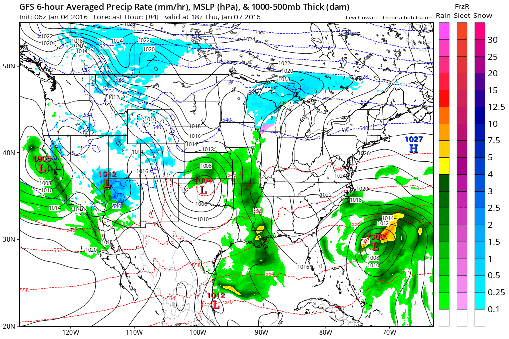
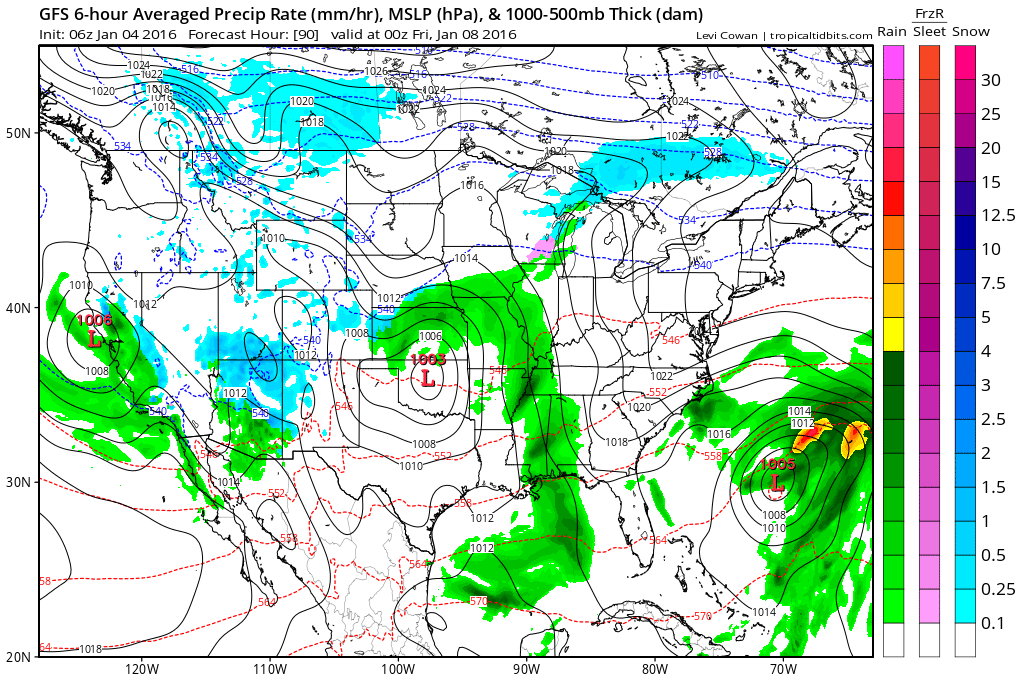
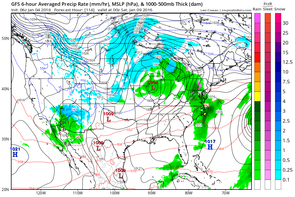
A couple of maps today
This is the GFS guidance. Green represents rain. You can see it is showing rain in our region by Thursday morning. Perhaps as early as late Wednesday night. Then, rain should come to an end by Friday evening and night.
This image is for Thursday around 11 am
This image is for Thursday evening
This last image is for Friday evening.

Here are the current river stage forecasts. You can click your state and then the dot for your location. It will bring up the full forecast and hydrograph.
Click Here For River Stage Forecasts…
Here are some current forecast hydrographs. These will be updated each day with new information.


Smithland Lock and Dam

Paducah, Kentucky Forecast Stage

Cairo, Illinois

Cape Girardeau, Missouri
Clickable map


Here are the current river stage forecasts. You can click your state and then the dot for your location. It will bring up the full forecast and hydrograph.
Click Here For River Stage Forecasts…

No snow anticipated.

Tuesday – No snow or ice anticipated.
Wednesday – No snow or ice anticipated.
Wednesday night – No snow or ice anticipated.
Thursday – No snow or ice anticipated.
Friday – No snow or ice anticipated.

No major changes in this update.

River flooding continues to be the main concern.
Monitor the latest crest forecast numbers.
Avoid flooded roadways.

Rivers have crested in most areas. But, they still remain high.
Avoid flooded roadways.

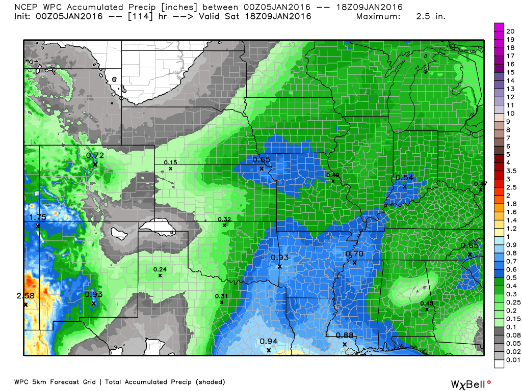
The wild card for this update will be rainfall totals on Thursday and Friday. This appears to be an event that would produce 0.40″-0.60″. Some data indicates amounts greater than 0.60″. So, the wild card will be whether rainfall totals will exceed that amount.

How much precipitation should we expect over the next few days?
Watching Thursday and Friday for some rain chances.
Here are the expected rainfall totals for the Thursday/Friday system. This is the WPC map. It is a little heavier than I went. But, still some time. Will keep an eye on it.

Can we expect severe thunderstorms over the next 24 to 48 hours? Remember that a severe thunderstorm is defined as a thunderstorm that produces 58 mph winds or higher, quarter size hail or larger, and/or a tornado.
The thunderstorm threat level will be a ZERO for the next seven day.
.
No risk of severe weather through the rest of this week.

We have regional radars and local city radars – if a radar does not seem to be updating then try another one. Occasional browsers need their cache cleared. You may also try restarting your browser. That usually fixes the problem. Occasionally we do have a radar go down. That is why I have duplicates. Thus, if one fails then try another one.
If you have any problems then please send me an email beaudodson@usawx.com
WEATHER RADAR PAGE – Click here —
We also have a new national interactive radar – you can view that radar by clicking here.
Local interactive city radars include St Louis, Mt Vernon, Evansville, Poplar Bluff, Cape Girardeau, Marion, Paducah, Hopkinsville, Memphis, Nashville, Dyersburg, and all of eastern Kentucky – these are interactive radars. Local city radars – click here
NOTE: Occasionally you will see ground clutter on the radar (these are false echoes). Normally they show up close to the radar sites – including Paducah.


Here is the official 6-10 day and 8-14 day temperature and precipitation outlook. Check the date stamp at the top of each image (so you understand the time frame).
The forecast maps below are issued by the Weather Prediction Center (NOAA).


The latest 8-14 day temperature and precipitation outlook. Note the dates are at the top of the image. These maps DO NOT tell you how high or low temperatures or precipitation will be. They simply give you the probability as to whether temperatures or precipitation will be above or below normal.


Here are the current river stage forecasts. You can click your state and then the dot for your location. It will bring up the full forecast and hydrograph.
Click Here For River Stage Forecasts…

Who do you trust for your weather information and who holds them accountable?
I have studied weather in our region since the late 1970’s. I have 37 years of experience in observing our regions weather patterns. My degree is in Broadcast Meteorology from Mississippi State University and an Associate of Science (AS). I am currently working on my Bachelor’s Degree in Geoscience.
My resume includes:
Member of the American Meteorological Society.
NOAA Weather-Ready Nation Ambassador.
Meteorologist for McCracken County Emergency Management. I served from 2005 through 2015.
I own and operate the Southern Illinois Weather Observatory.
Recipient of the Mark Trail Award, WPSD Six Who Make A Difference Award, Kentucky Colonel, and the Caesar J. Fiamma” Award from the American Red Cross.
In 2009 I was presented with the Kentucky Office of Highway Safety Award.
Recognized by the Kentucky House of Representatives for my service to the State of Kentucky leading up to several winter storms and severe weather outbreaks.
I am also President of the Shadow Angel Foundation which serves portions of western Kentucky and southern Illinois.
There is a lot of noise on the internet. A lot of weather maps are posted without explanation. Over time you should learn who to trust for your weather information.
My forecast philosophy is simple and straight forward.
- Communicate in simple terms
- To be as accurate as possible within a reasonable time frame before an event
- Interact with you on Twitter, Facebook, and the blog
- Minimize the “hype” that you might see on television or through other weather sources
- Push you towards utilizing wall-to-wall LOCAL TV coverage during severe weather events
I am a recipient of the Mark Trail Award, WPSD Six Who Make A Difference Award, Kentucky Colonel, and the Caesar J. Fiamma” Award from the American Red Cross. In 2009 I was presented with the Kentucky Office of Highway Safety Award. I was recognized by the Kentucky House of Representatives for my service to the State of Kentucky leading up to several winter storms and severe weather outbreaks.
If you click on the image below you can read the Kentucky House of Representatives Resolution.

Many of my graphics are from www.weatherbell.com – a great resource for weather data, model data, and more


You can sign up for my AWARE email by clicking here I typically send out AWARE emails before severe weather, winter storms, or other active weather situations. I do not email watches or warnings. The emails are a basic “heads up” concerning incoming weather conditions.