We have our first sponsor for the blog. Milner and Orr Funeral Home and Cremation Services located in Paducah, Kentucky and three other western Kentucky towns – at Milner and Orr they believe in families helping families.
![]()

This forecast update covers far southern Illinois, far southeast Missouri, and far western Kentucky. See the coverage map on the right side of the blog.
Sunday – Partly to mostly cloudy. Light rain and snow possible. Colder. Temperatures will hold steady or fall through the day. High temperatures will be in the 30’s. West/northwest winds at 10-15 mph with gusts to 30 mph. Winds chills will be in the teens.
Sunday night – Just a few clouds. Colder than recent nights. Low temperatures will be in the teens to lower 20’s. Northwest winds at 10 mph will make it feel even colder.
Monday – Partly sunny and cold. High temperatures only in the 20’s. Light and variable winds becoming northeast at 5-10 mph.
Monday night – Just a few clouds. Not quite as cold. Low temperatures will be in the 20’s. South winds at 5-10 mph.
Tuesday – Partly sunny and cold. High temperatures in the 30’s
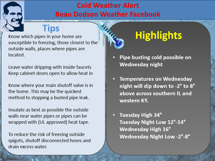
BITTERLY COLD AIR ARRIVES ON WEDNESDAY NIGHT …
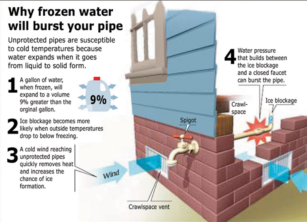
PIPE BUSTING COLD POSSIBLE…
LOW TEMPERATURES WILL BE IN THE SINGLE DIGITS ON THURSDAY MORNING…

Current Temperatures Around The Local Area


An explanation of what is happening in the atmosphere over the coming days.
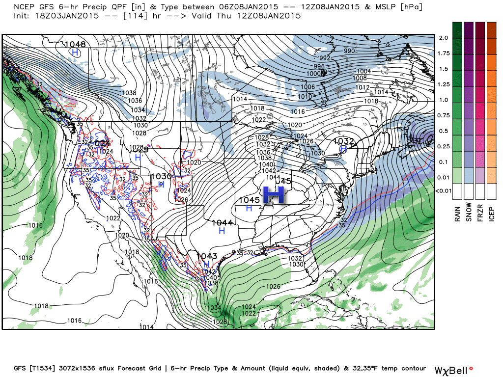
Our big rain maker has left the area. The heaviest totals fell over parts of southeast Missouri and southern Illinois. I had to shift the heaviest rain axis early yesterday morning. Oringinally it appeared that the heavier totals would be over KY/TN.
Many people reported thunderstorms on Saturday. A bit unusual for the first part of January.
Here comes the cold weather…
Temperatures today will fall through the afternoon hours. This cold weather will last into next weekend. The coldest air arrives on Wednesday night and Thursday morning. I am expecting single digits by Thursday morning.
Gusty winds today will make it feel even colder. Some light rain and snow will also be possible today.
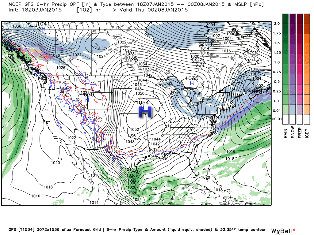
This is all in response to a MASSIVE high pressure center. Near record high pressure is possible later this week. The area of high pressure will likely be in the 1040 to 1050 mb range. Impressive to say the least.
This weather map is for Wednesday night and Thursday morning. You can see the huge high pressure center advancing east/southeast. Images from www.weatherbell.com
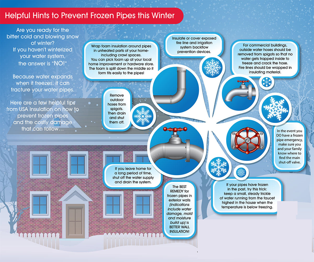
These low temperatures could cause problems with some water pipes. If you have pipes that need to be protected then keep the forecast in mind.
Right now I am not tracking any major precipitation events.
The main story will be the cold weather.
Click for large view

Increased rain and snow chances today

Bitterly cold air later this week

The wild card tells you where the most uncertainty is in the current forecast.
Wild card in this forecast – No wild card in today’s forecast.

Can we expect severe thunderstorms over the next 24 to 48 hours? Remember that a severe thunderstorm is defined as a thunderstorm that produces 58 mph winds or higher, quarter size hail or larger, and/or a tornado.
Thunderstorm threat level is ZERO

Will I need to take action?
Start thinking about protecting your water pips on Wednesday night. I know some of you have had problems the last few years.

How much rain should this system produce over our region?
No rain today into Thursday.

No significant snow is forecast for our local counties.

Cold weather through next weekend.
There could be some sort of precipitation late next week or weekend. Will monitor.
WEATHER RADAR PAGE – Click here —
NOTE: Occasionally you will see ground clutter on the radar (these are false echoes). Normally they show up close to the radar sites – including Paducah.

Regional Radar – Click on radar to take you our full radar page.


Regional Radar
![]()
Current WARNINGS (a warning means take action now). Click on your county to drill down to the latest warning information. Keep in mind that there can be a 2-3 minute delay in the updated warning information.
I strongly encourage you to use a NOAA Weather Radio or warning cell phone app for the most up to date warning information. Nothing is faster than a NOAA weather radio.


Color shaded counties are under some type of watch, warning, advisory, or special weather statement. Click your county to view the latest information.

Missouri Warnings

Illinois Warnings

Kentucky Warnings

Please visit your local National Weather Service Office by clicking here. The National Weather Service Office, for our region, is located in Paducah, Kentucky.

Here is the official 6-10 day and 8-14 day temperature and precipitation outlook. Check the date stamp at the top of each image (so you understand the time frame).
The forecast maps below are issued by the Weather Prediction Center (NOAA).


The latest 8-14 day temperature and precipitation outlook. Note the dates are at the top of the image. These maps DO NOT tell you how high or low temperatures or precipitation will be. They simply give you the probability as to whether temperatures or precipitation will be above or below normal.


Many of my graphics are from www.weatherbell.com – a great resource for weather data, model data, and more


This blog was inspired by ABC 33/40’s Alabama Weather Blog – view their blog
Current tower cam view from the Weather Observatory- Click here for all cameras.

Southern Illinois Weather Observatory

The Weather Observatory

Southern Illinois Weather Observatory
WSIL TV 3 has a number of tower cameras. Click here for their tower camera page & Illinois Road Conditions

Marion, Illinois
WPSD TV 6 has a number of tower cameras. Click here for their tower camera page & Kentucky Road Conditions & Kentucky Highway and Interstate Cameras

Downtown Paducah, Kentucky
Benton, Kentucky Tower Camera – Click here for full view

Benton, Kentucky

I24 Paducah, Kentucky

I24 Mile Point 9 – Paducah, KY

I24 – Mile Point 3 Paducah, Kentucky

You can sign up for my AWARE email by clicking here I typically send out AWARE emails before severe weather, winter storms, or other active weather situations. I do not email watches or warnings. The emails are a basic “heads up” concerning incoming weather conditions.