
We have our first sponsor for the blog. Milner and Orr Funeral Home and Cremation Services located in Paducah, Kentucky and three other western Kentucky towns – at Milner and Orr they believe in families helping families.
![]()

This forecast update covers far southern Illinois, far southeast Missouri, and far western Kentucky. See the coverage map on the right side of the blog.
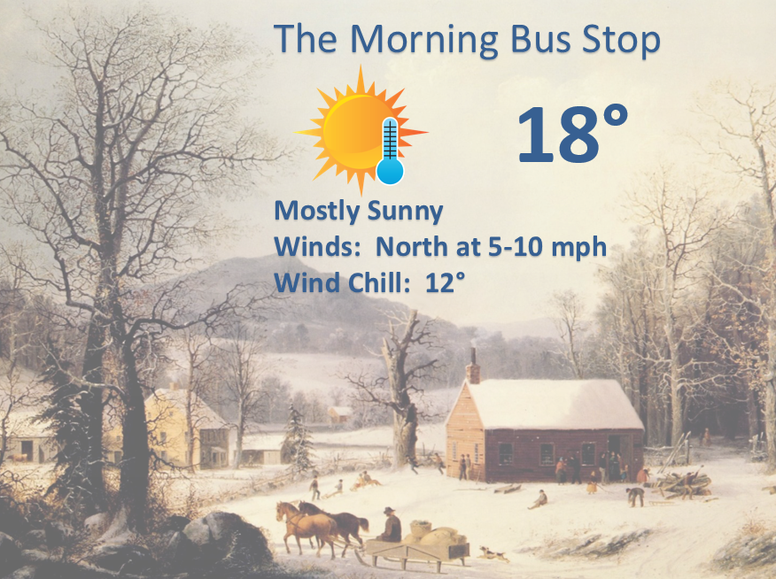
Monday – Mostly sunny. Cold. High temperatures only in the 20’s. Northwest winds at 5-10 mph.
Monday night – Partly cloudy. Seasonably cold temperatures. Low temperatures in the middle 20’s. Temperatures may rise a few degrees after 3 am. Southwest winds at 5 mph
Tuesday – Partly sunny and cold – windy at times. High temperatures only in the lower 30’s. Winds from the southwest early and becoming northwest in the afternoon at speeds of 10-25 mph
Tuesday night – Mostly cloudy – windy at times. A chance fora snow shower or snow squall. Low temperatures in the lower to middle teens. North/northwest winds at 5-10 mph.
Wednesday – Bitterly cold – well below normal temperatures. A chance for a morning snow shower. Highs only in the teens. North winds at 10-25 mph with gusts above 30 mph. Wind chills in the -5 to 10 above range.
Wednesday night – Bitterly cold. Dangerously cold. Low temperatures from -4 to 5 above. North-northwest winds at 5-15 mph. Wind chill values below zero.
BITTERLY COLD AIR ARRIVES ON Wednesday into Thursday …
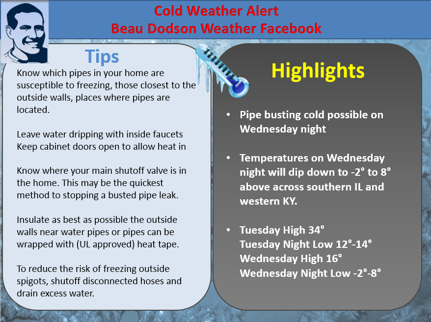
PIPE BUSTING COLD POSSIBLE…
LOW TEMPERATURES WILL BE IN THE SINGLE DIGITS ON THURSDAY MORNING…

Current Temperatures Around The Local Area


An explanation of what is happening in the atmosphere over the coming days.
Weather Headlines
- Dangerously cold temperatures and wind chills this week
- Snow showers or snow squall possible Tuesday night
- Watching a precipitation maker for later this weekend
Temperatures have fallen quite a bit over the region since Saturday. This is in response to a couple of cold fronts that have and will move through the region. The coldest temperatures will arrive on Tuesday night into Thursday morning.
I am expecting lower teens on Tuesday night/Wednesday morning and single digit readings by Thursday morning. These type of temperatures have historically caused some problems in our region.
A band of light snow or a snow squall is possible Tuesday night or Wednesday morning. This is along the cold front. Historically these type of snow bands tend to be a bit heavier than forecast. At least something to monitor.
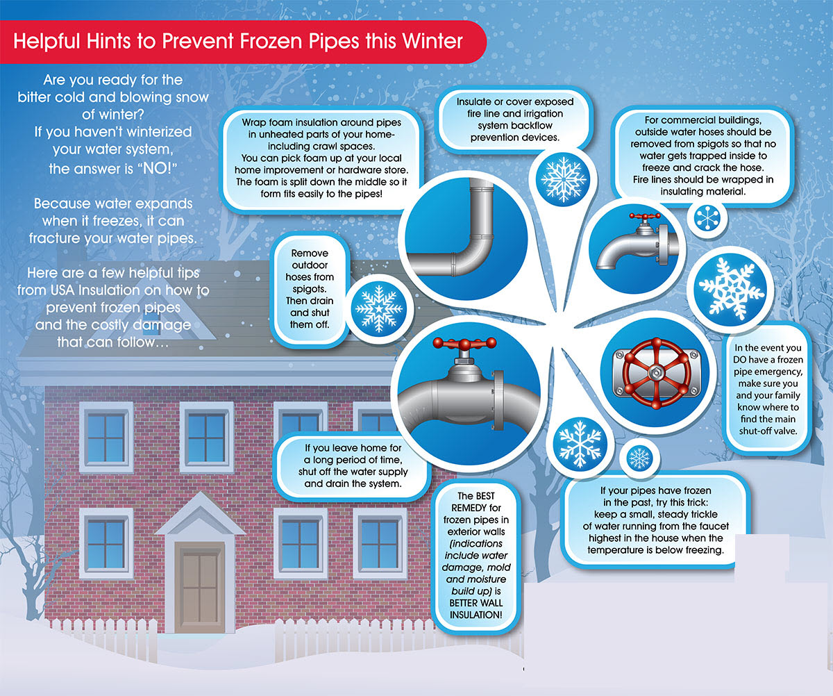
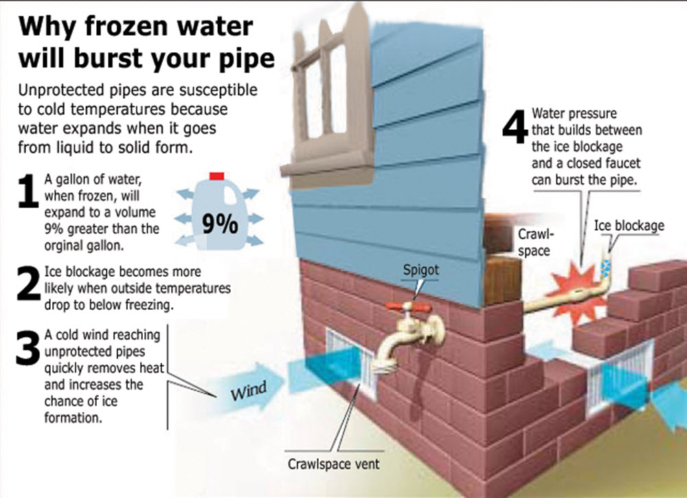
This message is most pertinent to those with poorly protected water pipes
Historically in our region an event like this causes…
1. Deaths
2. An increase in home and business fires
4. Risk of frostbite to children, elderly, and those working outdoors
5. Hundreds of thousands of dollars in damage to water pipes/water damage/fire damage
6. Those of you who had damage from the cold over the last couple of years will likely want to make sure you are prepared for this cold weather event.
Tips…
— Check on elderly residents during this upcoming cold weather event
— Make sure you have followed advice on protecting your home and businesses from busted pipe and water damage
— Bring in pets and protect outdoor animals
— Use common sense when it comes to utilizing heating sources for your home and businesses.
Pipe busting cold temperatures are forecast by Thursday morning. Area residents are encouraged to double check their precautionary measures to prevent damage to homes and businesses.
Let’s remember the elderly, as well during this time. Historically events like this claim lives and cause pipe damage.
Leading up to the coldest night we will experience temperatures in the teens on Tuesday night and high temperatures only in the teens on Wednesday. This will set the stage for the extreme cold on Wednesday night.
Assuming the current forecast numbers are correct, I am forecasting -2 to 6 above temperature readings over southern Illinois and western Kentucky. The below zero readings are most likely from Carbondale, Illinois to Shawneetown, Illinois northward.
The low single digits readings are likely from there southward and over western Kentucky.
Here is some advice to help protect your homes and businesses. I grabbed some of these tips from online sources.
Bring in those pets who are not used to extreme temperatures and check on people who are susceptible to the extreme cold.
Make sure smoke and carbon monoxide detectors are installed and working.
Don’t use stoves, ovens or grills as sources of heat. Use extreme caution with space heaters, and fireplaces.
Protect your pipes and let faucets drip, even at a trickle, in order to prevent them from freezing. You can also keep cabinet doors open near pipes to allow warm air to circulate around them.
The main story will be the cold weather.
Dangerous wind chill values are possible on Wednesday/Wednesday evening. These readings can cause frostbite to exposed skin in a very short time span.
These numbers are WIND CHILLS (not temperatures)
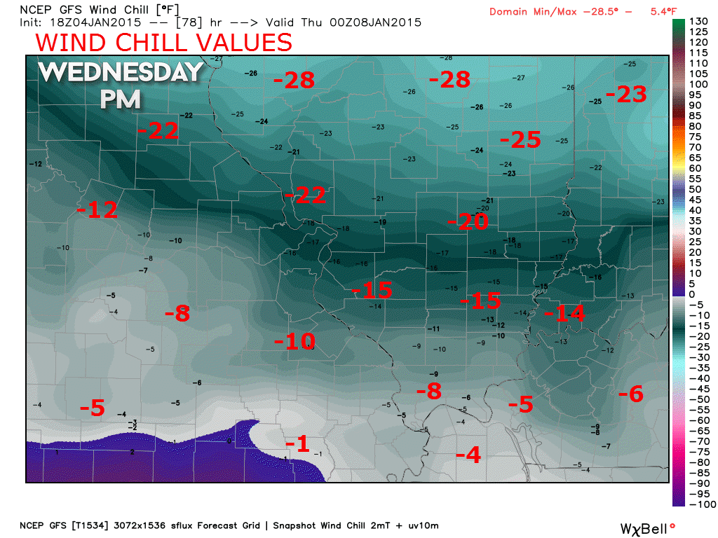
Click for large view

I added snow showers for Tuesday night

Bitterly cold air later this week. A snow shower on Tuesday night/Wednesday morning.

The wild card tells you where the most uncertainty is in the current forecast.
Wild card in this forecast – perhaps a snow shower on Tuesday night or Wednesday morning. Confidence is lower than normal as to whether this happen.

Will I need to take action?
Start thinking about protecting your water pips on Wednesday night. I know some of you have had problems the last few years.
Sensitive outdoor animals may have problems with this cold snap. This is especially true on Tuesday into Thursday morning.

How much rain should this system produce over our region?
A snow shower possible Tuesday night and Wednesday morning

Perhaps a snow shower or snow squall on Tuesday night along the front. Still a bit early to know if there will be enough of a band to accumulate. Historically snow showers along an arctic front can produce a bit of accumulation.
Cold weather through next weekend.
I am watching for a possible overrunning precipitation event for Saturday through Monday. Details are still vaugue. It appears a system moving out of the southwest United States will push into our region. The exact track of this system will determine what happens in our local counties.
This system is still 5-6 days away. I have little confidence in the eventual outcome. Keep checking back.
WEATHER RADAR PAGE – Click here —
NOTE: Occasionally you will see ground clutter on the radar (these are false echoes). Normally they show up close to the radar sites – including Paducah.

Regional Radar – Click on radar to take you our full radar page.


Regional Radar
![]()
Current WARNINGS (a warning means take action now). Click on your county to drill down to the latest warning information. Keep in mind that there can be a 2-3 minute delay in the updated warning information.
I strongly encourage you to use a NOAA Weather Radio or warning cell phone app for the most up to date warning information. Nothing is faster than a NOAA weather radio.


Color shaded counties are under some type of watch, warning, advisory, or special weather statement. Click your county to view the latest information.

Missouri Warnings

Illinois Warnings

Kentucky Warnings

Please visit your local National Weather Service Office by clicking here. The National Weather Service Office, for our region, is located in Paducah, Kentucky.

Here is the official 6-10 day and 8-14 day temperature and precipitation outlook. Check the date stamp at the top of each image (so you understand the time frame).
The forecast maps below are issued by the Weather Prediction Center (NOAA).


The latest 8-14 day temperature and precipitation outlook. Note the dates are at the top of the image. These maps DO NOT tell you how high or low temperatures or precipitation will be. They simply give you the probability as to whether temperatures or precipitation will be above or below normal.


Many of my graphics are from www.weatherbell.com – a great resource for weather data, model data, and more


This blog was inspired by ABC 33/40’s Alabama Weather Blog – view their blog
Current tower cam view from the Weather Observatory- Click here for all cameras.

Southern Illinois Weather Observatory

The Weather Observatory

Southern Illinois Weather Observatory
WSIL TV 3 has a number of tower cameras. Click here for their tower camera page & Illinois Road Conditions

Marion, Illinois
WPSD TV 6 has a number of tower cameras. Click here for their tower camera page & Kentucky Road Conditions & Kentucky Highway and Interstate Cameras

Downtown Paducah, Kentucky
Benton, Kentucky Tower Camera – Click here for full view

Benton, Kentucky

I24 Paducah, Kentucky

I24 Mile Point 9 – Paducah, KY

I24 – Mile Point 3 Paducah, Kentucky

You can sign up for my AWARE email by clicking here I typically send out AWARE emails before severe weather, winter storms, or other active weather situations. I do not email watches or warnings. The emails are a basic “heads up” concerning incoming weather conditions.