
We have our first sponsor for the blog. Milner and Orr Funeral Home and Cremation Services located in Paducah, Kentucky and three other western Kentucky towns – at Milner and Orr they believe in families helping families.
![]()

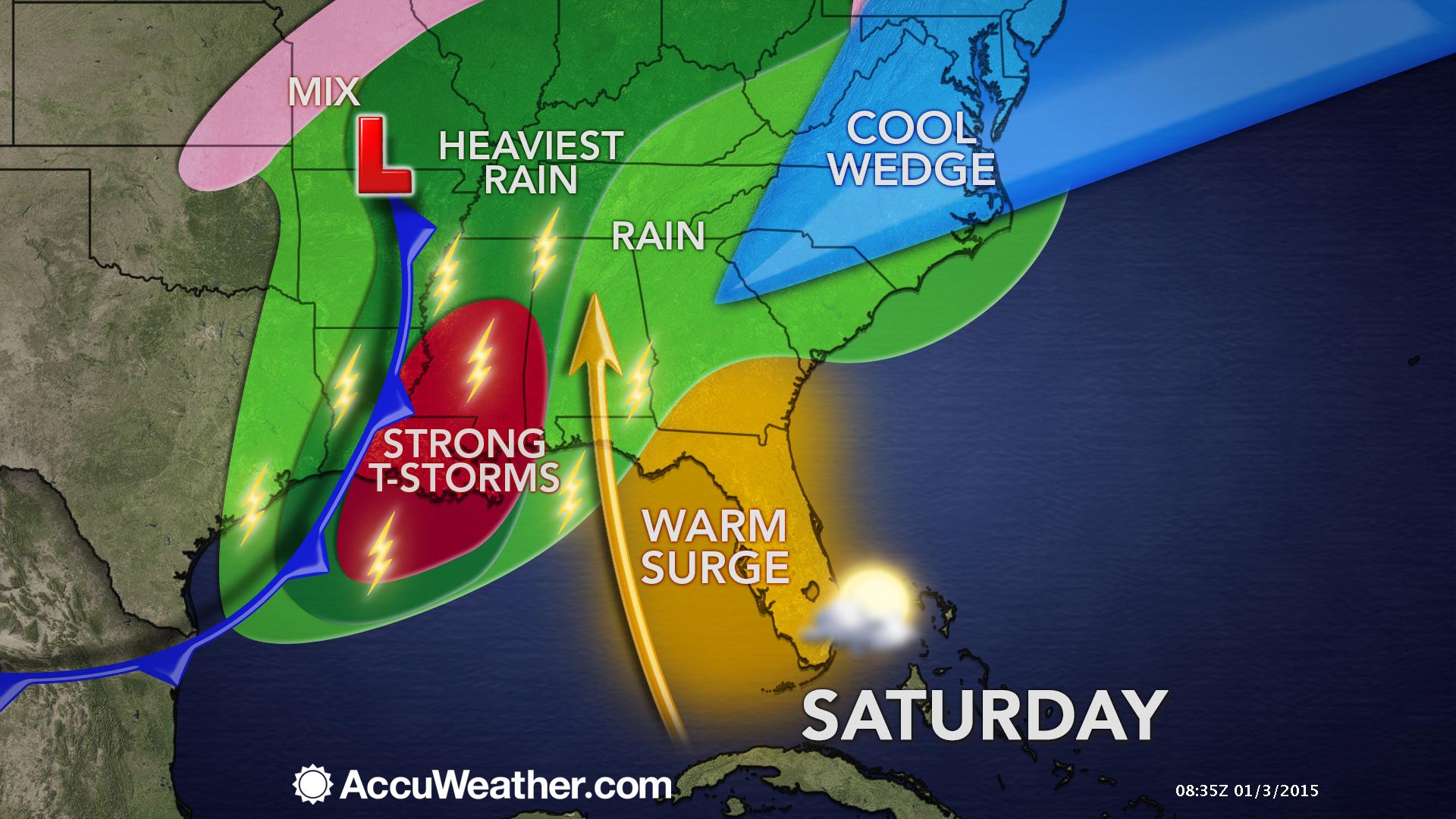
This forecast update covers far southern Illinois, far southeast Missouri, and far western Kentucky. See the coverage map on the right side of the blog.
Saturday – Cloudy with rain likely. Fog. Some thunderstorms likely. Temperatures will be colder over our western and northern counties. Warmer air towards western Kentucky. Highs will be in the 30’s and 40’s to the north and west. Highs will rise into the 50’s over parts of far southern Illinois and western Kentucky. Southeast winds will become southwest at 10-15 mph. A strong thunderstorm possible with gusty winds and lightning.
WEATHER RADAR PAGE – Click here —
Saturday night – Cloudy with some evening rain possible. A thunderstorm possible, as well. Temperatures will fall into the 30’s. Southwest winds will become westerly late at night. Wind speeds of 10-20 mph. Winds may be gusty at times in excess of 30 mph. Rain chances decrease after midnight.
Sunday – Partly to mostly cloudy. Maybe a flurry. Colder. Temperatures will hold steady. High temperatures will be in the 30’s. West/northwest winds at 10-15 mph with gusts to 20 mph.
Sunday night – Just a few clouds. Colder than recent nights. Low temperatures will be in the teens to lower 20’s. Northwest winds at 10 mph will make it feel even colder.
Monday – Partly sunny and cold. High temperatures only in the 20’s. Light and variable winds.

Current Temperatures Around The Local Area


An explanation of what is happening in the atmosphere over the coming days.
An active weather pattern for the next 24 hours and then bitterly cold air invades the region next week.
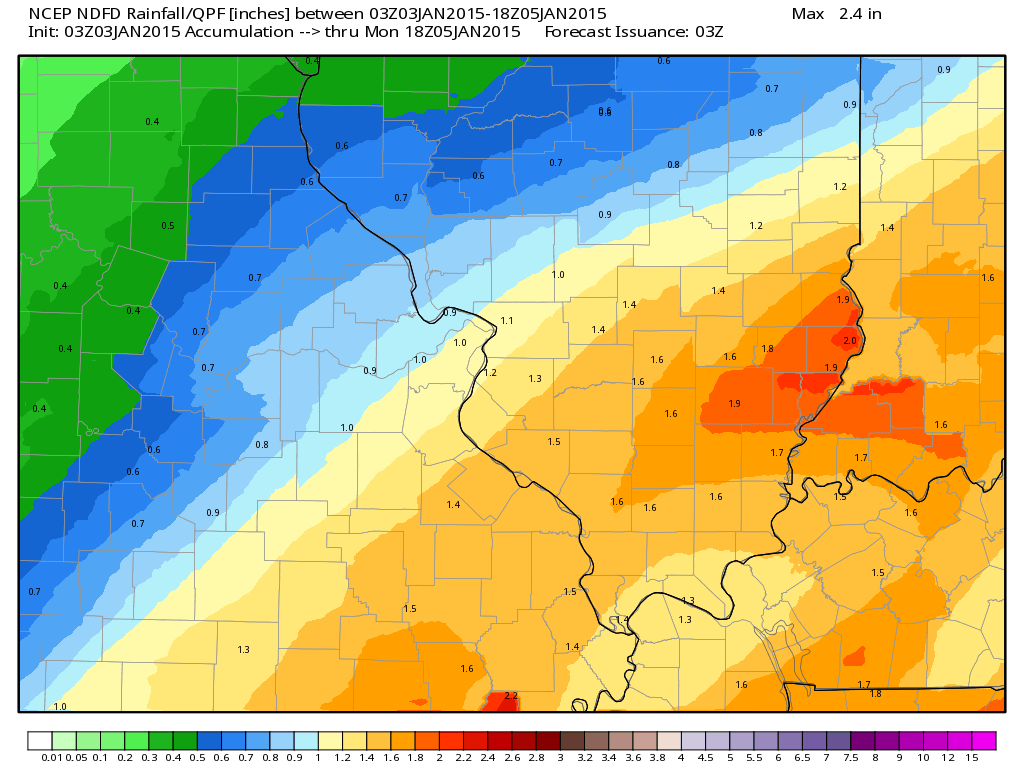
Note I shifted the heaviest rain band west and north a bit from earlier updates. That is start to finish totals.
Dense fog for some areas this morning.
Some small stream and ditches will flood today over parts of southeast Missouri and southern Illinois – smaller chances of that in western Kentucky.
Widespread showers and some thunderstorms will be the rule today into this evening. Some locally heavy downpours will also be possible. An unusual January weather set-up will push temperatures into the 50’s and perhaps lower 60’s for parts of southern Illinois and western Kentucky. These warmer temperatures will mean that thunderstorms will also be possible.
Rainfall totals from start to finish with this system will likely be in excess of 1″ for most counties. Isolated reports of 2″ will be possible, as well.
The heaviest totals have shifted a bit north vs earlier forecast data. It appears the heaviest totals will run across parts of southeast Missouri into southern Illinois. Earlier I was thinking that parts of west Kentucky would have the heaviest totals. But, overnight on Friday a band set up over parts of southeast MO into southern IL. Thus, the heaviest totals will likely end up in that band,
Here is the latest rainfall forecast grids from the National Weather Service – you can see the heavier band has shifted north just a bit.
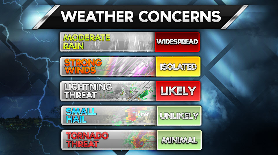
Severe weather concerns?
Widespread severe weather is not anticipated, but a few isolated severe storms can’t be ruled out. The main concern would be a few reports of damaging winds. The tornado risk is minimal, although there will be quite a bit of shear in the area. Monitor updates in case warnings are issued via your NOAA Weather Radio or local media.
A much colder air mass arrives on Sunday and Sunday night. As a matter of fact we may see temperatures dip into the teens by Monday morning.
Even colder air arrives for the middle of next week behind a strong cold front. This will be the coldest air of the season. Perhaps some single digit readings for some of our local counties. We shall see.
Today’s weather concerns
The concern for an isolated severe storm will mainly be over western Kentucky and Tennessee. The overall risk is minimal. Better chances for severe storms will exist further south along the Gulf of Mexico.

No major changes. I did mention an isolated severe thunderstorm for today into this evening. The overall risk is small for any given area and is centered mainly on Kentucky and Tennessee where the warmer temperatures will reside.

An isolated strong or severe thunderstorm today. The main concern would be a report or two of high winds. The tornado risk is very small.
Locally heavy rain may cause some small stream flooding in a few counties. No major flooding expected.

The wild card tells you where the most uncertainty is in the current forecast.
Wild card in this forecast – today’s wild card centers around the thunderstorm threat. Maybe an isolated severe storm? Overall risk is small. But, that is our wild card.
The second wild card is how low temperatures will dip by Monday morning. Right now I am thinking 16 to 22 degrees.

Can we expect severe thunderstorms over the next 24 to 48 hours? Remember that a severe thunderstorm is defined as a thunderstorm that produces 58 mph winds or higher, quarter size hail or larger, and/or a tornado.
Thunderstorm threat level is TWO
That means that an isolated severe thunderstorm will be possible. The main concern will be over western Kentucky.


Live Lightning Data – zoom and pan: Click here
Live Lightning Data with sound (click the sound button on the left side of the page): Click here

Will I need to take action?
Umbrellas! Otherwise, monitor any watches or warnings that might be issued later today. The main concern will be over Kentucky and Tennessee where an isolated severe thunderstorm will be possible. The main threat would be a report or two of damaging winds. Otherwise, lightning and heavy downpours will be possible.

How much rain should this system produce over our region?
Quite a bit of rain today into this evening. Expect most areas to pick up a total of 1″+ from this system (from start to finish – including what fell on Friday)

No significant snow is forecast for our local counties. Maybe some flurries on Sunday and again around Tuesday into Wednesday as another strong cold front pushes through the area. That front will not have much moisture to work with. Thus, the threat for snow or ice is not expected to be an issue.
I am watching a system for next weekend. Low confidence in that happening (at least at this point). Winter is slipping away from us! We are now about 7 weeks away from Meteorological Spring!

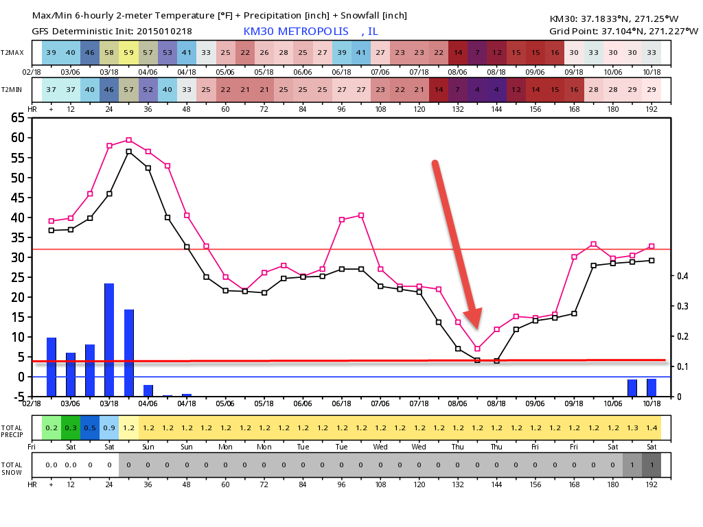
The big story in the extended forecast will be the bitterly cold temperatures. The lowest readings should arrive on Wednesday and Thursday morning. Right now I am thinking temperatures will dip down to 6 to 12 degrees for many of our local counties. That is pretty cold for not having snow on the ground.
Here is the temperature forecast graph for Metropolis, Illinois for the upcoming week. Notice how cold we are by Wednesday and Thursday. The GFS model is showing some single digit readings.
The pink line would be high temperatures
The black line would be low temperatures
You can also read the high and low temp numbers at the top of the graphic (different color shadings)
The next weather maker should arrive next weekend into the early part of the following week. That is a long way off and confidence is low concerning any details. Just something I am monitoring.

We have regional radars and local city radars – if a radar does not seem to be updating then try another one. Occasional browsers need their cache cleared. You may also try restarting your browser. That usually fixes the problem. Occasionally we do have a radar go down. That is why I have duplicates. Thus, if one fails then try another one.
If you have any problems then please send me an email beaudodson@usawx.com
WEATHER RADAR PAGE – Click here —
We also have a new national interactive radar – you can view that radar by clicking here.
Local interactive city radars include St Louis, Mt Vernon, Evansville, Poplar Bluff, Cape Girardeau, Marion, Paducah, Hopkinsville, Memphis, Nashville, Dyersburg, and all of eastern Kentucky – these are interactive radars. Local city radars – click here
NOTE: Occasionally you will see ground clutter on the radar (these are false echoes). Normally they show up close to the radar sites – including Paducah.

Regional Radar – Click on radar to take you our full radar page.


Regional Radar


Day 1 Severe Weather Outlook from the Storm Prediction Center – Storm Prediction Center
What does thunderstorms, marginal, slight, enhanced, medium, and high risk mean? Click here

Current Severe thunderstorm and tornado watches from the Storm Prediction Center. The Storm Prediction Center is in charge of issuing watches. Our local National Weather Service Office in Paducah, Kentucky is in charge of issuing warnings.
Remember that a watch means that conditions are favorable for severe weather. Severe weather MIGHT develop over the coming hours. Watches normally last 4 to 8 hours. Monitor updates for possible warnings. A watch is a step below a warning.
A warning means to take immediate action to protect you and your family. Warnings usually last from 15 to 45 minutes. A warning means that a storm is moving into your area.
For additional watch information click here

![]()
Current WARNINGS (a warning means take action now). Click on your county to drill down to the latest warning information. Keep in mind that there can be a 2-3 minute delay in the updated warning information.
I strongly encourage you to use a NOAA Weather Radio or warning cell phone app for the most up to date warning information. Nothing is faster than a NOAA weather radio.


Color shaded counties are under some type of watch, warning, advisory, or special weather statement. Click your county to view the latest information.

Missouri Warnings

Illinois Warnings

Kentucky Warnings

Please visit your local National Weather Service Office by clicking here. The National Weather Service Office, for our region, is located in Paducah, Kentucky.

Here is the official 6-10 day and 8-14 day temperature and precipitation outlook. Check the date stamp at the top of each image (so you understand the time frame).
The forecast maps below are issued by the Weather Prediction Center (NOAA).


The latest 8-14 day temperature and precipitation outlook. Note the dates are at the top of the image. These maps DO NOT tell you how high or low temperatures or precipitation will be. They simply give you the probability as to whether temperatures or precipitation will be above or below normal.


Many of my graphics are from www.weatherbell.com – a great resource for weather data, model data, and more


This blog was inspired by ABC 33/40’s Alabama Weather Blog – view their blog
Current tower cam view from the Weather Observatory- Click here for all cameras.

Southern Illinois Weather Observatory

The Weather Observatory

Southern Illinois Weather Observatory
WSIL TV 3 has a number of tower cameras. Click here for their tower camera page & Illinois Road Conditions

Marion, Illinois
WPSD TV 6 has a number of tower cameras. Click here for their tower camera page & Kentucky Road Conditions & Kentucky Highway and Interstate Cameras

Downtown Paducah, Kentucky
Benton, Kentucky Tower Camera – Click here for full view

Benton, Kentucky

I24 Paducah, Kentucky

I24 Mile Point 9 – Paducah, KY

I24 – Mile Point 3 Paducah, Kentucky

You can sign up for my AWARE email by clicking here I typically send out AWARE emails before severe weather, winter storms, or other active weather situations. I do not email watches or warnings. The emails are a basic “heads up” concerning incoming weather conditions.