We have our first sponsor for the blog. Milner and Orr Funeral Home and Cremation Services located in Paducah, Kentucky and three other western Kentucky towns – at Milner and Orr they believe in families helping families.
![]()

This forecast update covers far southern Illinois, far southeast Missouri, and far western Kentucky. See the coverage map on the right side of the blog.
Friday – Rain likely today. It will be a raw and chilly day with highs in the 30’s. Light winds.
Friday night – Cloudy with rain likely. Chilly with temperatures in the 30’s. Temperatures may rise near sunrise. East winds at 5-10 mph.
Saturday – Cloudy with rain likely. Some thunderstorms possible. Temperatures will be colder over our western and northern counties. Warmer air towards western Kentucky. Highs will be in the 30’s and 40’s to the north and west. Highs will rise into the 50’s over parts of far southern Illinois and western Kentucky. Southeast winds will become southwest at 10-15 mph.
Saturday night – Cloudy with some evening rain possible. A thunderstorm possible, as well. Temperatures will fall into the 30’s. Southwest winds will become westerly late at night. Wind speeds of 10-20 mph. Winds may be gusty at times in excess of 30 mph. Rain chances decrease after midnight.
Sunday – Partly to mostly cloudy. Colder. Temperatures will hold steady. High temperatures will be in the 30’s. West/northwest winds at 10-15 mph with gusts to 20 mph.

Current Temperatures Around The Local Area


An explanation of what is happening in the atmosphere over the coming days.
Some patchy precipitation this morning is mainly in the form of light rain and some sleet pellets. Temperatures will rise above freezing over the entire area early this morning.
It will remain chilly today. A warm front is, however, on the way! We will feel that by Saturday and Saturday afternoon. Don’t get used to the milder air. It won’t last long.
There will be a wide range of temperatures across our region over the next couple of days. This is because the low pressure center is forecast to track in or near our local counties. It will be milder on the east and southeast side of the area of low pressure. It will be colder on the west and north side of the low.
Here is an example of the kind of temperature spread that I am expecting as the warm front moves through our area.
Let’s walk through the temperatures on Friday into Sunday
Images are from www.weatherbell.com
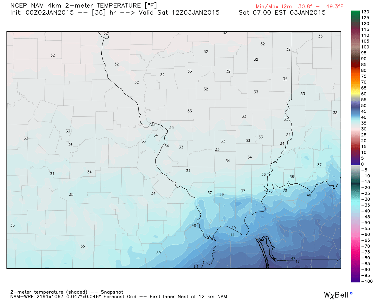
Here are the temperatures for 6 am on Saturday morning. You can see we are still quite chilly.
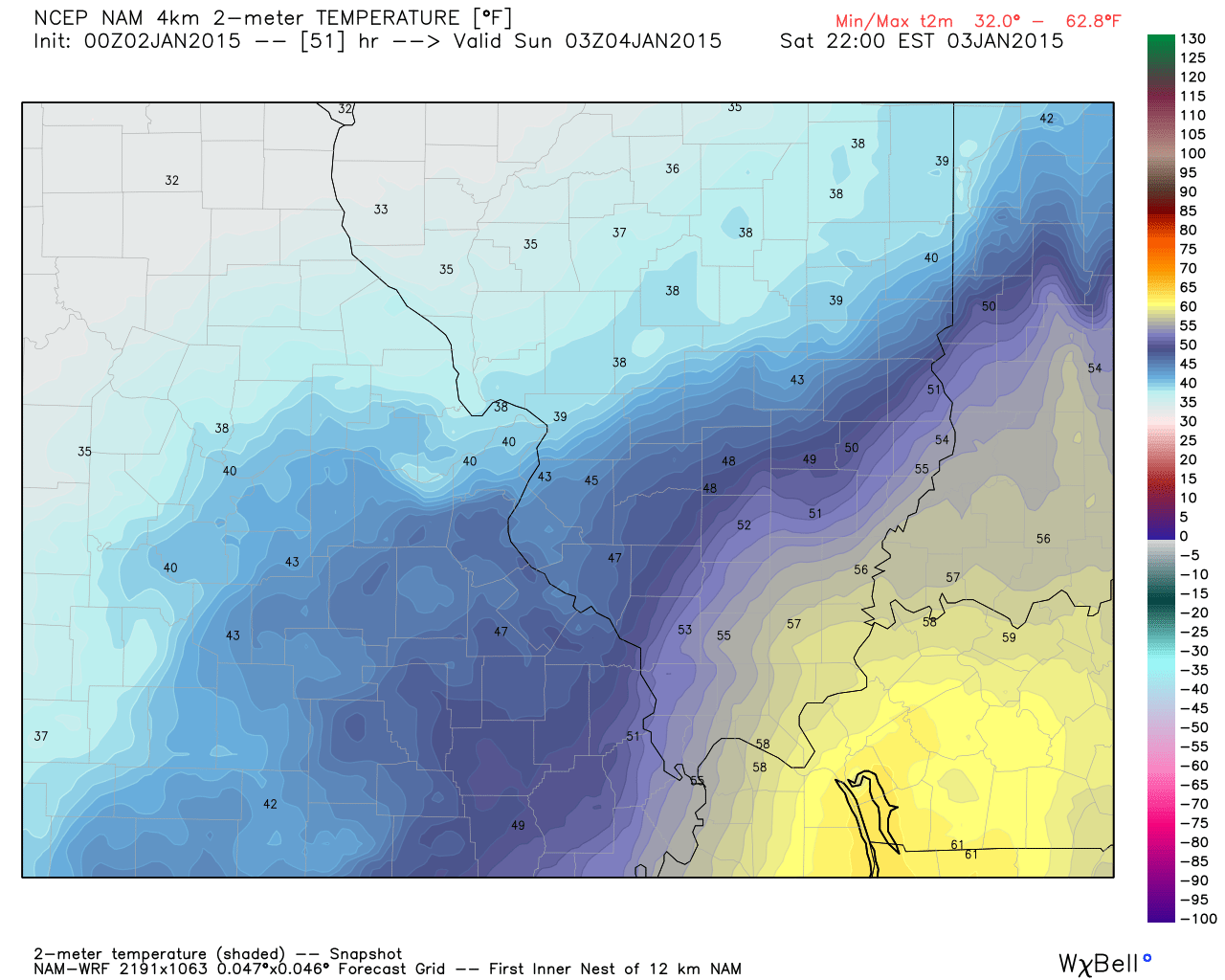
Here are the temperatures for around 2 or 3 pm on Saturday afternoon. You can see warmer air moving northward from Tennessee

Here are the temperatures for around 7 pm – 9 pm on Saturday night. Note how mild it is over parts of our region. This is in response to the low pulling through our region and passing off to the north. There are even some 60 degree readings on this chart (near Land Between the Lakes)
Temperatures will fall soon after the rise as the front moves through.
These temperatures will be dependent on the path of the area of low pressure and the speed of the cold front as it pushes eastward through our region.
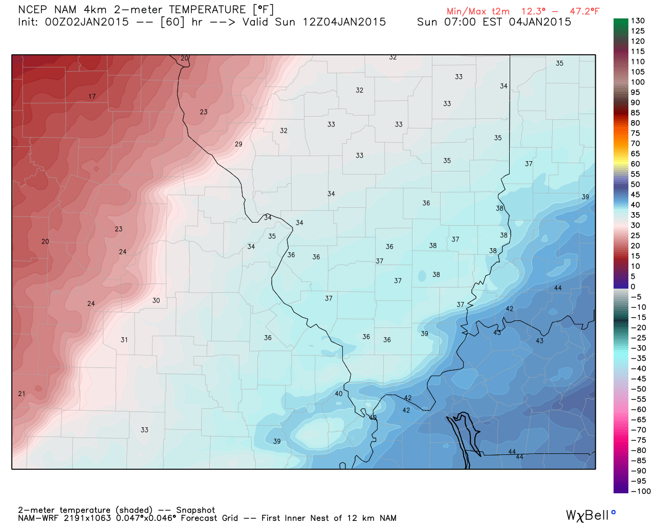
Now watch the colder air move in behind the cold front on Sunday.
An area of low pressure will push into our region over the next 48 hours. The low will move out of the Gulf of Mexico states and push northward. Rain and a few thunderstorms will accompany this area of low pressure. I am not expecting any severe thunderstorms. However, monitor the latest information on Saturday in case something changes. Perhaps a couple of heavier storms for western Kentucky.
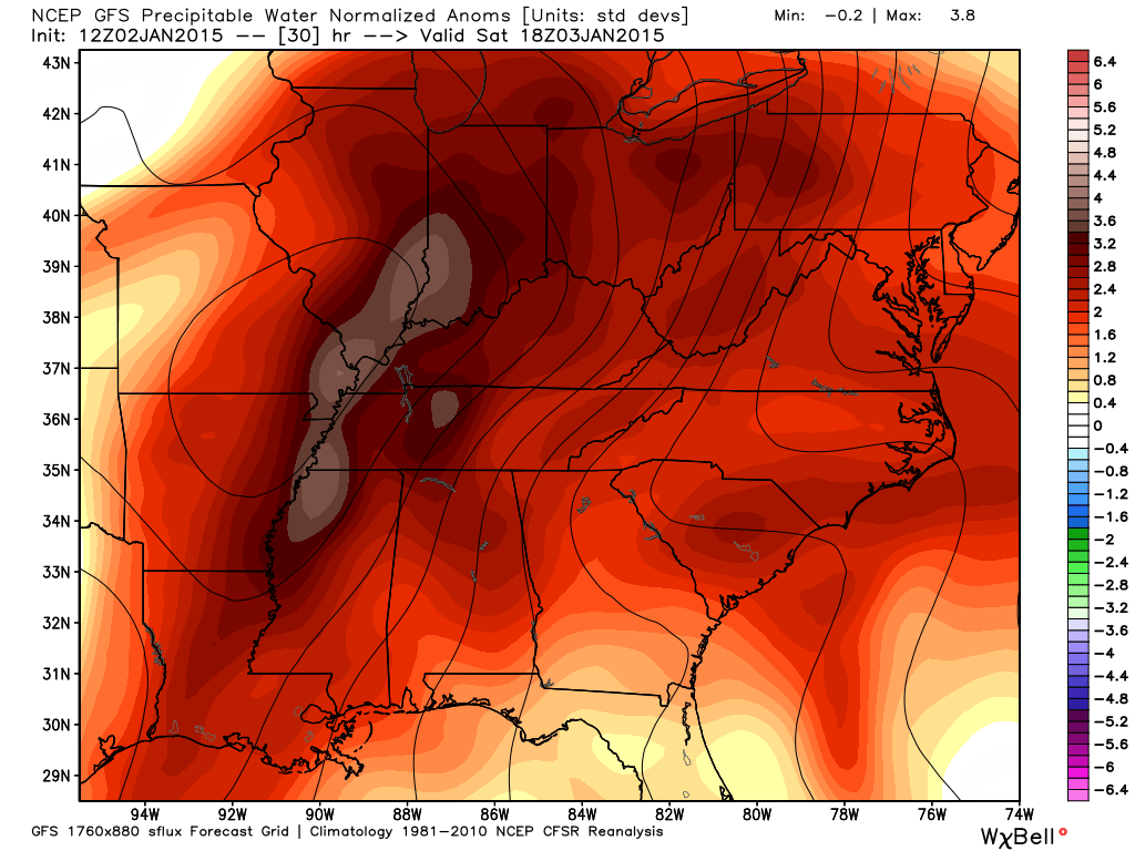
Check out these amazing PWAT anomalies for Saturday. PWAT indicates how much moisture is in the atmosphere. These numbers are near record levels. Thankfully this system is moving along, otherwise flooding would be an issue.
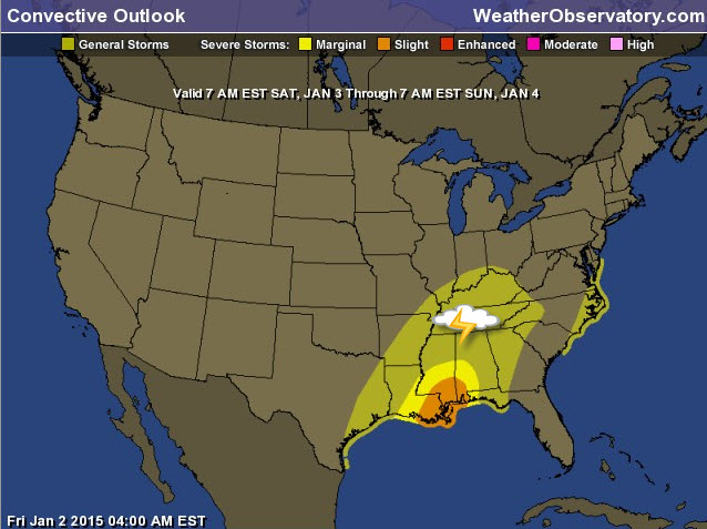
Here is the Storm Prediction Center’s severe weather outlook. Our region is in the general thunderstorm outline. That means that some storms are possible, but should remain below severe levels. The darker colors near the Gulf of Mexico means a few severe storms.
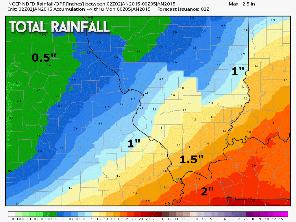
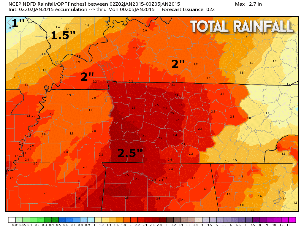
There could be some locally heavy rain with this system. Rainfall totals will likely exceed 1″ over many areas. Some pockets of 2″ can’t be ruled out over parts of western Kentucky and western Tennessee.
The rain will come to an end by later on Saturday night. Clouds and cold temperatures will be the rule on Sunday. Perhaps some partly cloudy sky conditions. Sometimes it is hard to scour out the clouds during the winter months (as you may have noticed over the past month or two).
We have regional radars and local city radars – if a radar does not seem to be updating then try another one. Occasional browsers need their cache cleared. You may also try restarting your browser. That usually fixes the problem. Occasionally we do have a radar go down. That is why I have duplicates. Thus, if one fails then try another one.
WEATHER RADAR PAGE – Click here —

No major changes. Complicated temperature forecast for the next couple of days. There will be a decent gradient from west to east across the region. Colder air to the west/northwest and warmer air over the central and eastern counties.

No major concerns. There could be a little wintry mix early this morning, but temperatures are going to rise above freezing around sunrise. Many areas have already risen above freezing.

The wild card tells you where the most uncertainty is in the current forecast.
Wild card in this forecast – the wild card in this forecast is how many of us will hear thunder over the next 48 hours. Welcome to January!

Can we expect severe thunderstorms over the next 24 to 48 hours? Remember that a severe thunderstorm is defined as a thunderstorm that produces 58 mph winds or higher, quarter size hail or larger, and/or a tornado.
Thunderstorm threat level is ONE


Live Lightning Data – zoom and pan: Click here
Live Lightning Data with sound (click the sound button on the left side of the page): Click here

Will I need to take action?
Umbrellas will be in order over the next couple of days.

How much rain should this system produce over our region?
Quite a bit of rain is in the forecast for today through Saturday night. The bulk of the rain will fall tonight into Saturday evening.
These are the official National Weather Service grids. That is why they have such detailed numbers. This gives you at least a general idea on what might fall. I doubt it will be exactly as shown. But, generally this should be how the precipitation is spread over the area. Heaviest over the southern and southeastern counties. Lesser amounts further north and west.

Should we just stop looking for winter weather? Maybe then it will snow.
Right now I do not see any significant snow in the 1-3 day winter forecast. There will be a cold front push into the region early next week. There could be some flurries with the front. Right now it does not appear to be a big deal.
Keep checking back.

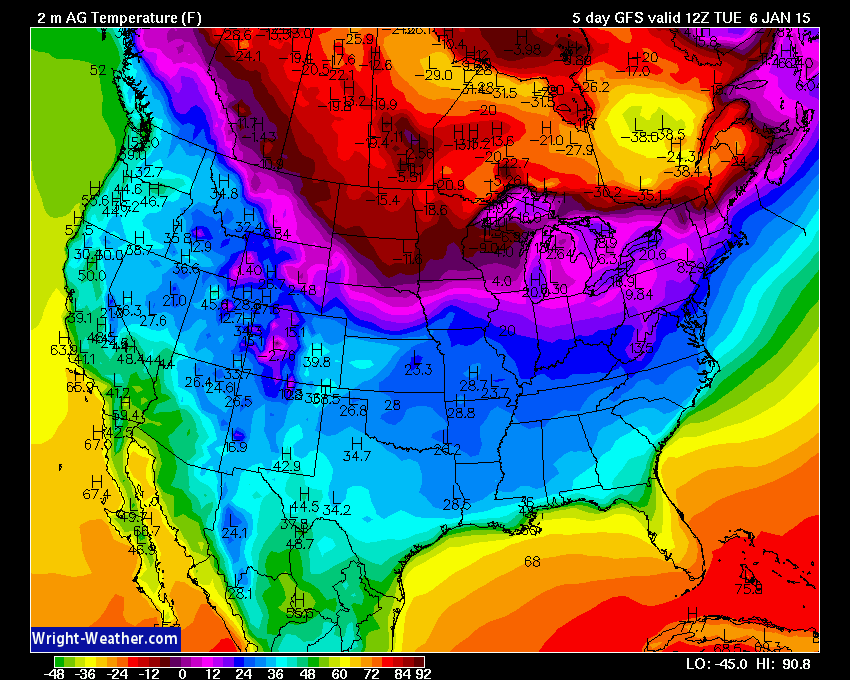
The long range forecast is full of cold temperatures. A strong cold front arrives on Tuesday afternoon and night. This front will push through the region and bring a reinforcing shot of cold air. This next air-mass will likely be the coldest air mass of the winter season, thus far. I would not be surprised to see temperatures dip into the 8 to 14 degree range over parts of our region. Most likely this would be over the northern parts of southern Illinois.
The coldest nights will likely be on Wednesday and Thursday mornings. This is when parts of the region might experience single digits or lower teens. Still several days away.
I am not tracking any snowstorms.
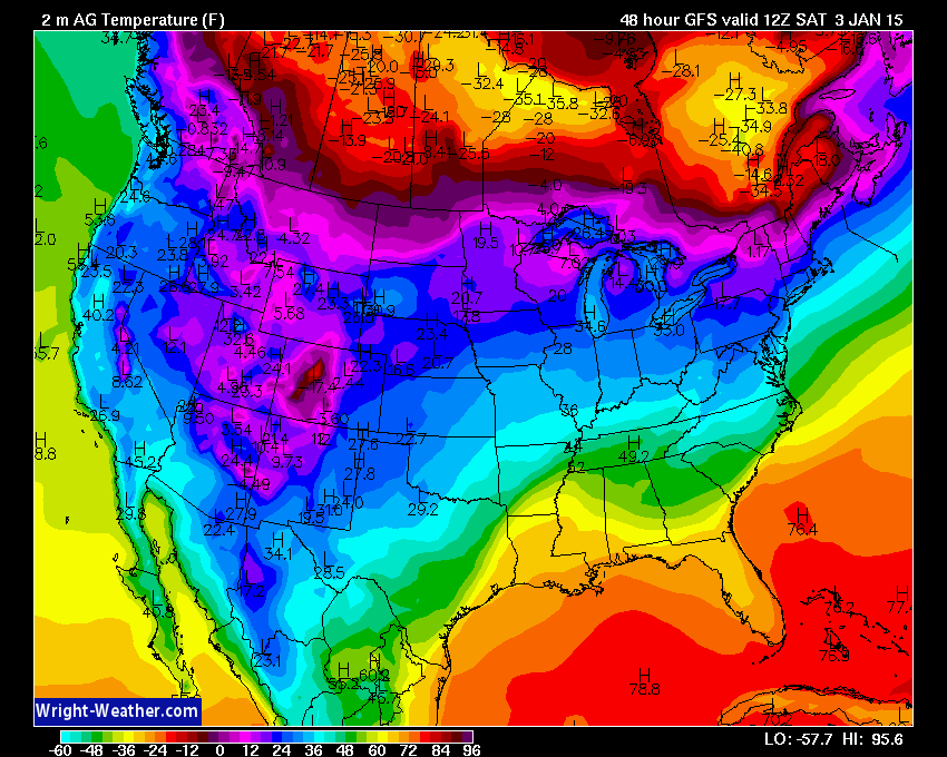
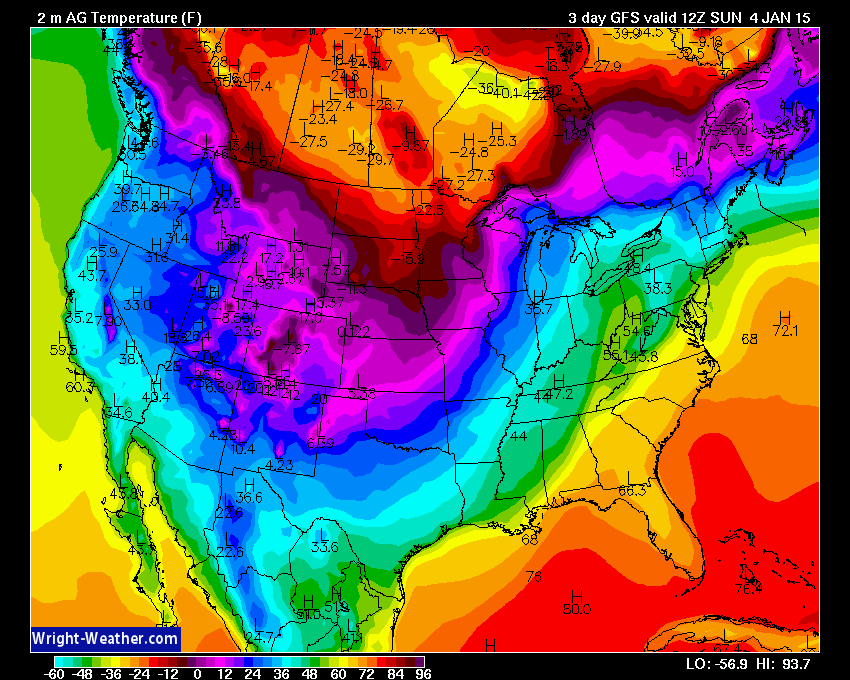
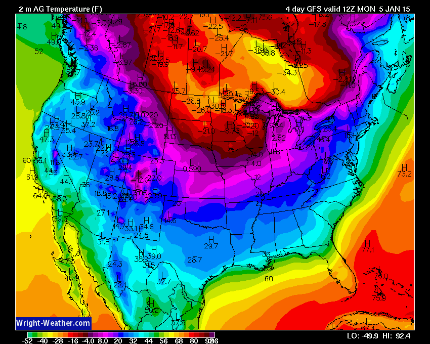
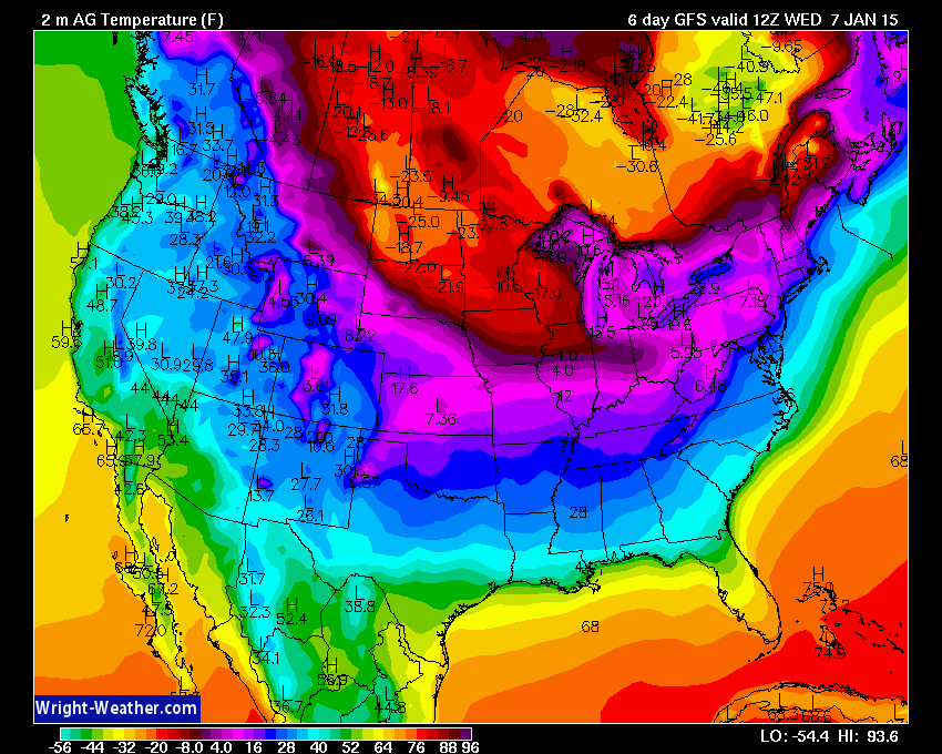
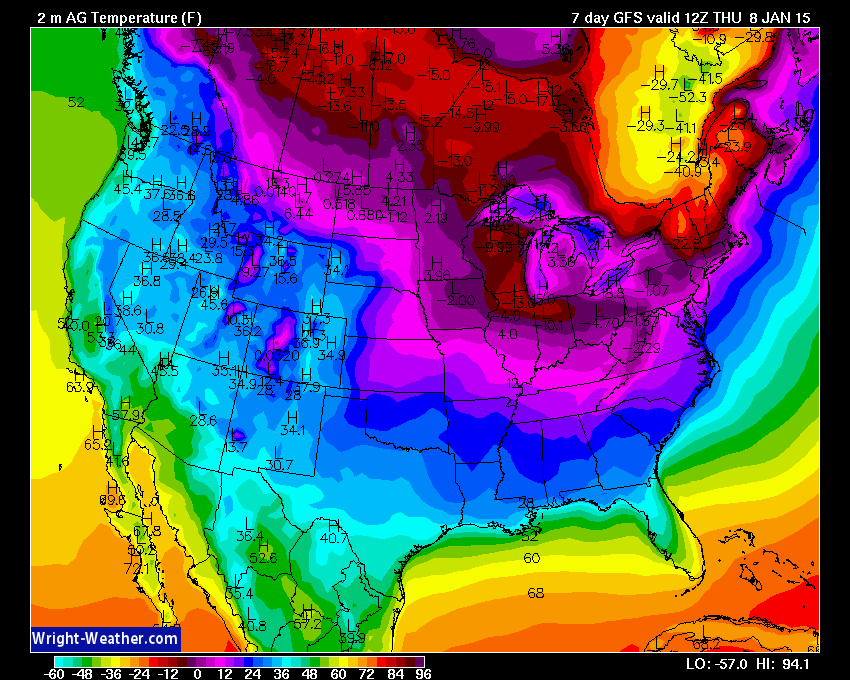
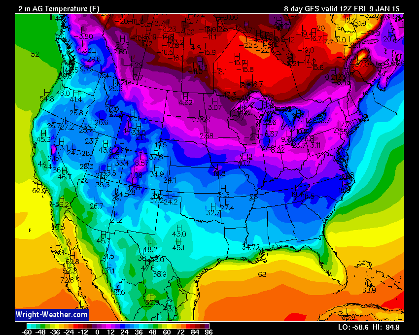
Let’s take a look at temperatures over the coming week – follow the cold blast!
You can click each image for a larger size. Images are from www.wright-weather.com
The scale is at the bottom of the image. Each image is for 6 am each morning.
Starting with Saturday morning lows
Sunday morning
Monday Morning
Tuesday Morning
Wednesday Morning
Thursday Morning
Friday Morning

We have regional radars and local city radars – if a radar does not seem to be updating then try another one. Occasional browsers need their cache cleared. You may also try restarting your browser. That usually fixes the problem. Occasionally we do have a radar go down. That is why I have duplicates. Thus, if one fails then try another one.
If you have any problems then please send me an email beaudodson@usawx.com
WEATHER RADAR PAGE – Click here —
We also have a new national interactive radar – you can view that radar by clicking here.
Local interactive city radars include St Louis, Mt Vernon, Evansville, Poplar Bluff, Cape Girardeau, Marion, Paducah, Hopkinsville, Memphis, Nashville, Dyersburg, and all of eastern Kentucky – these are interactive radars. Local city radars – click here
NOTE: Occasionally you will see ground clutter on the radar (these are false echoes). Normally they show up close to the radar sites – including Paducah.

Regional Radar – Click on radar to take you our full radar page.


Regional Radar

Day 1 Severe Weather Outlook from the Storm Prediction Center – Storm Prediction Center
What does thunderstorms, marginal, slight, enhanced, medium, and high risk mean? Click here

![]()
Current WARNINGS (a warning means take action now). Click on your county to drill down to the latest warning information. Keep in mind that there can be a 2-3 minute delay in the updated warning information.
I strongly encourage you to use a NOAA Weather Radio or warning cell phone app for the most up to date warning information. Nothing is faster than a NOAA weather radio.


Color shaded counties are under some type of watch, warning, advisory, or special weather statement. Click your county to view the latest information.

Missouri Warnings

Illinois Warnings

Kentucky Warnings

Please visit your local National Weather Service Office by clicking here. The National Weather Service Office, for our region, is located in Paducah, Kentucky.

Here is the official 6-10 day and 8-14 day temperature and precipitation outlook. Check the date stamp at the top of each image (so you understand the time frame).
The forecast maps below are issued by the Weather Prediction Center (NOAA).


The latest 8-14 day temperature and precipitation outlook. Note the dates are at the top of the image. These maps DO NOT tell you how high or low temperatures or precipitation will be. They simply give you the probability as to whether temperatures or precipitation will be above or below normal.


Many of my graphics are from www.weatherbell.com – a great resource for weather data, model data, and more


This blog was inspired by ABC 33/40’s Alabama Weather Blog – view their blog
Current tower cam view from the Weather Observatory- Click here for all cameras.

Southern Illinois Weather Observatory

The Weather Observatory

Southern Illinois Weather Observatory
WSIL TV 3 has a number of tower cameras. Click here for their tower camera page & Illinois Road Conditions

Marion, Illinois
WPSD TV 6 has a number of tower cameras. Click here for their tower camera page & Kentucky Road Conditions & Kentucky Highway and Interstate Cameras

Downtown Paducah, Kentucky
Benton, Kentucky Tower Camera – Click here for full view

Benton, Kentucky

I24 Paducah, Kentucky

I24 Mile Point 9 – Paducah, KY

I24 – Mile Point 3 Paducah, Kentucky

You can sign up for my AWARE email by clicking here I typically send out AWARE emails before severe weather, winter storms, or other active weather situations. I do not email watches or warnings. The emails are a basic “heads up” concerning incoming weather conditions.