2 PM
No real changes
Light rain possible on Friday – mainly afternoon and evening. Rain may end up as a rain/snow mix and end as light snow for parts of western KY. Light event with little accumulation of snow.
Better chances for snow accumulation will be over eastern portions of the region – east of Kentucky Lake most likely.
Storm is tracking pretty far south and east.
We have our first sponsor for the blog. Milner and Orr Funeral Home and Cremation Services located in Paducah, Kentucky and three other western Kentucky towns – at Milner and Orr they believe in families helping families.
![]()

This forecast update covers far southern Illinois, far southeast Missouri, and far western Kentucky. See the coverage map on the right side of the blog.
Remember that weather evolves. Check back frequently for updates, especially during active weather.
I will update the blog once or twice today – mainly to cover any changes on the Friday system.
Thursday – A mix of sun and clouds today. It will be a bit cooler. Highs will only be in the 40’s. North winds at 5-10 mph.
Morning School Bus Stop Weather – Quite a few clouds today. Morning temperatures in the 30’s. North winds at 5-10 mph.
Afternoon School Bus Stop Weather – Quite a few clouds today. Afternoon temperatures in the 40’s. North winds at 5-10 mph.
Thursday night – Partly to mostly cloudy. Cool. Low temperatures in the upper 20’s to lower 30’s. North winds at 5 mph.
Friday – Clouds. A chance for rain or rain/snow showers. This will mainly be over our eastern and southeastern counties. Further north and west will depend on the storm track. Iffy right now for most of us picking up anything of significance. Better chances as you travel east. Highs will mainly be in the 30’s to around 40. Northeast winds at 10 mph.
Friday night – Precipitation coming to an end. Otherwise, cloudy will low temperatures in the 20’s. North winds becoming northwest at 5-10 mph.
Saturday – Partly sunny sky conditions. High temperatures will be in the 40’s. Winds from the west at 5-10 mph.
Sunday will bring another chance for clouds and perhaps some showers. Above normal temperatures, once again. Gusty winds at times.

Current Temperatures Around The Local Area


An explanation of what is happening in the atmosphere over the coming days…
Weather Highlights
- Calm today
- Chance for rain or snow on Friday/Friday evening
- Some rain showers possible Sunday
- Colder on Monday, but nothing extreme
Another calm day for the region. One of many over the past few weeks. If you thought the weather has been boring or quiet then you would be right…for the most part. We even have a drought developing over parts of the area. Not a very nice way to enter spring. Let’s hope we pick up some moisture…soon.
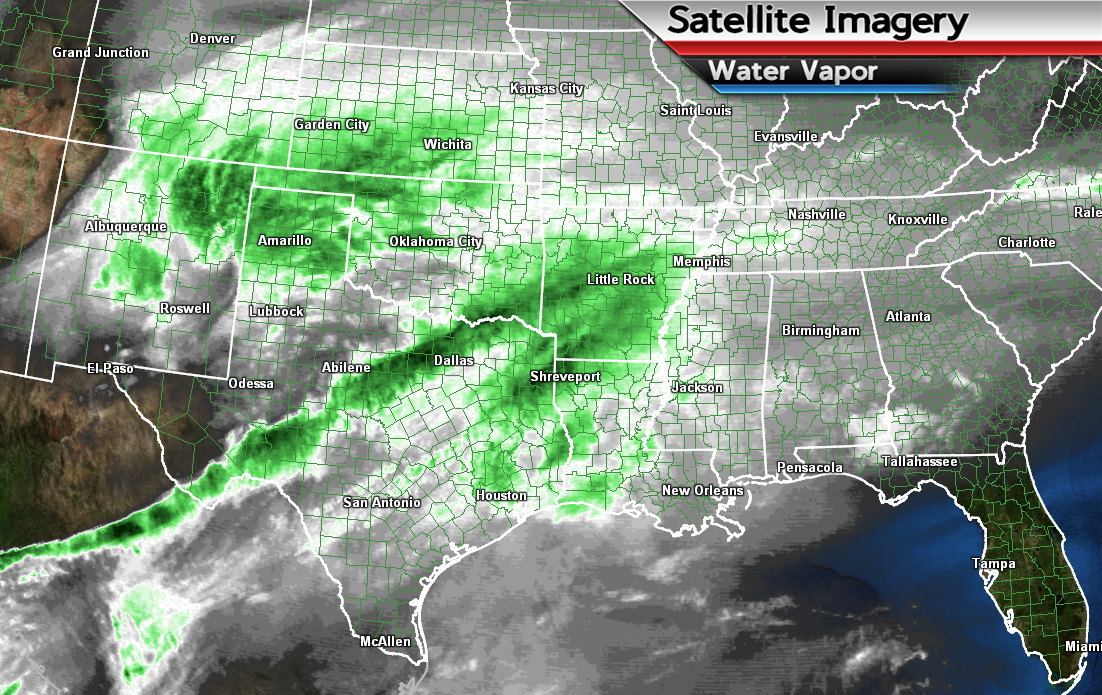
There will be quite a few clouds today as we watch a new storm system approach from the southwest. This system will track to the east over the coming 24 hours. You can clearly see the system on national radar and satellite
Here is the water vapor view form last evening. Just giving you an idea of the cloud mass and moisture to our southwest. That is all spreading eastward towards the Gulf of Mexico and southern United States. Cloud shield will clip us. That green on the satellite map is not rain. That is moisture – this is the water vapor image.

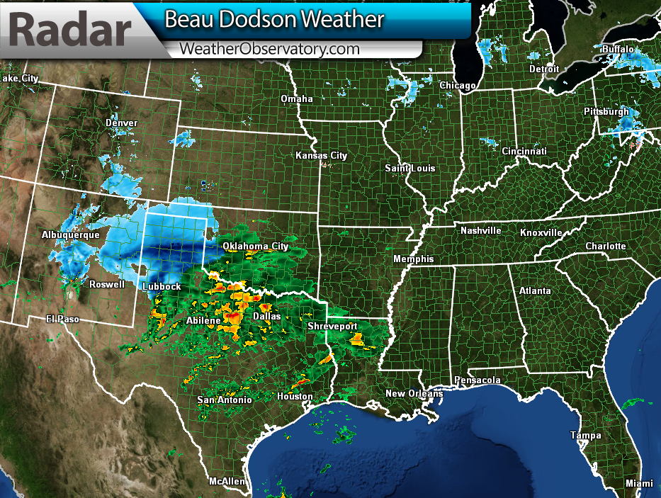
Here is the radar view from last evening – just to give you an idea of where this system is originating from.
On Friday precipitation should spread into parts of our region from the south. The best chance of precipitation will be over western Kentucky. Lesser chances over southeast Missouri and southern Illinois.
Right now the data is mixed as to how far north forecasters should place the rain rain/snow mix. Feel pretty good when I say that the further south and southeast you travel the better chances for precipitation on Friday.
With that said, the data does indicate at least some rain rain/snow over areas near Poplar Bluff towards far southern Illinois and then eastward. Not a lot of precipitation, but a little.
Temperatures on Friday should be warm enough for a rain/snow mix and perhaps even a change-over to snow for parts of our region – as the storm pulls away. The best chance for snow will be over parts of western Kentucky (mainly eastern parts). In order for the rain to change to snow it may have to come down at a decent pace. That would cause evaporational cooling and thus the rain would change to snow.
See the winter storm discussion for additional details on our winter weather event.
Saturday will be another calm day. A bit cooler with highs in the 40’s. Scattered showers possible again on Sunday.
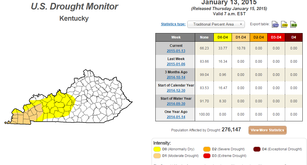
Is a drought developing?
Portions of our region are drier than normal. I know it might not feel like it, but the numbers are indicating abnormally dry weather for parts of western Kentucky. Moderate drought conditions are occurring over parts of western Kentucky and western Tennessee, as well.
Here is the latest drought monitor maps.
Click the image for a larger view
Here is the national drought monitor map
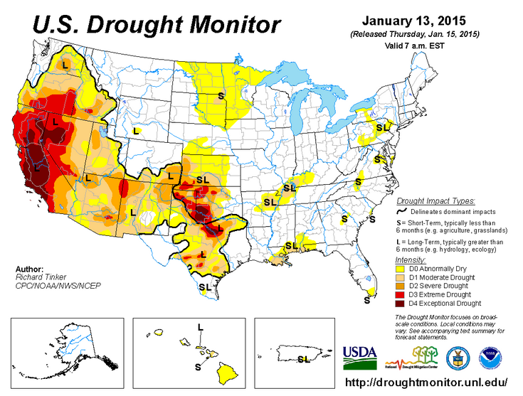
We will have to see what the coming 4-8 weeks bring to the region. My winter forecast was for colder than normal temperatures and drier than normal conditions.
Did you know that the Weather Observatory is funded by people like you? I rely on ad’s on this blog and individual donations. PayPal also allows you to set up a monthly recurring donation. I have had several people give $5, $10, and $20 a month. A recurring donation helps keep the weather information flowing. If you enjoy this blog, the Twitter account, the Facebook interaction, the weather radars, and all of the other information then consider making a donation or setting up a recurring donation (if you don’t use PayPal then contact me through email about how you can mail a donation) beaudodson@usawx.com
Thank you for your support!

Main changes to the forecast over the coming days will center around Friday’s rain rain/snow chances. Expect some changes as we move forward. Storm track will need to be pinned down in order to determine whether parts of our area might see some light snow accumulation.

No concerns today
Watching Friday’s precipitation maker. A chance for some snow over parts of our area by Friday into Friday evening. Mainly eastern counties and southeastern counties. Accumulation is not a sure bet with this system. I know there are snowfall forecast maps floating around showing several inches possible. But, I think it might be a bit premature to be forecasting those kind of amounts.
Check out our newest sponsors $5 meal! The DQ Grill and Chill (located across from Noble Park in Paducah, Kentucky) is the newest WeatherTalk Blog sponsor! A local business helping to sponsor the weather information that you have come to love so much.
They have a Facebook Page and I encourage you to check it out. DQ Grill and Chill on Facebook


The wild card tells you where the uncertainties are in the forecast
Wild card in this forecast – the wild on this forecast update will center around the chance for some precipitation on Friday into Friday evening as a low tracks well to our south. Some potential for snow in some of our counties. Most likely this will include the southeastern parts of our region.

Can we expect severe thunderstorms over the next 24 to 48 hours? Remember that a severe thunderstorm is defined as a thunderstorm that produces 58 mph winds or higher, quarter size hail or larger, and/or a tornado.
Thunderstorm threat level is ZERO


Will I need to take action?
No action today. A calm weather day

How much precipitation should we expect over the next few days?
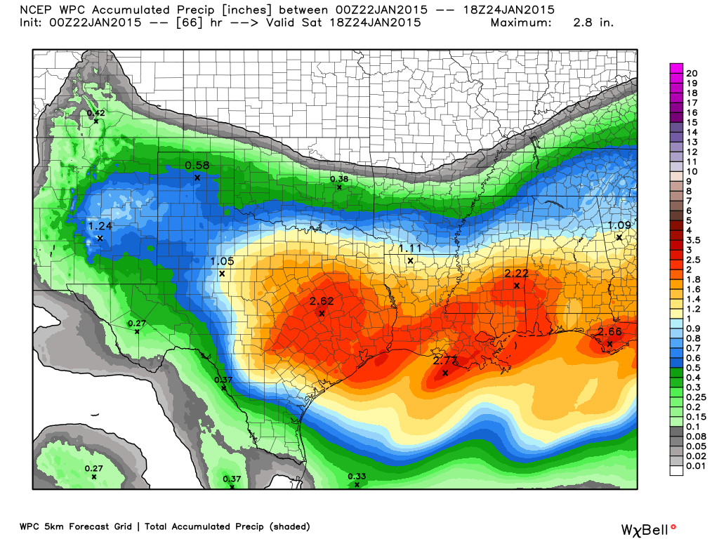
Here is the official precipitation forecast map through Saturday night.
You can see the bulk of this event will be to our east and south. But, it does clip parts of our region. Again, HIGHLY dependent on storm track. Image from www.weatherbell.com
We have a new sponsor! G&C Multi-Services out of Paducah, Kentucky. G & C Multi-Services is a service provider in Western Kentucky that provides industrial and commercial equipment fabrication, machine troubleshooting, repair and maintenance, and installation. They can custom fabricate steel, stainless, and aluminum products per customer specifications.
Visit their web-site here. Or click the ad below! They have a Facebook page and it can be viewed here.


I am currently watching a couple of precipitation makers. Our southern system (that I have been tracking for the last 10 days) is starting to shift slightly further north. This shift has meant that rain rain/snow has been added to the forecast for Friday. Still some questions as to whether there will be accumulating snow in our local counties. Check back frequently here or on the Beau Dodson Weather Facebook page for the latest information. These winter systems tend to evolve over time.
System One – Friday into Friday evening
- The area of low pressure will track well to our south
- The system may be far enough north to produce some rain rain/snow in our local counties. Still a lot of questions on whether there will be accumulating snow
- If there were to be accumulating snow then it would most likely be closer to the Land Between the Lakes than say Cape Girardeau, Missouri. Better chances as you travel east vs west.
Details:
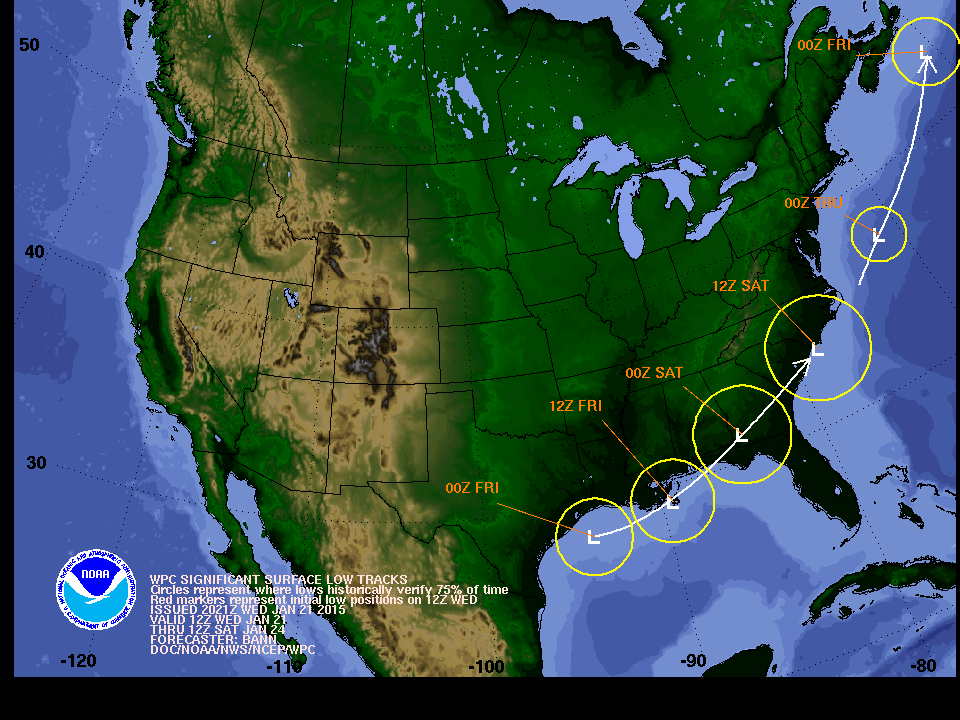
An area of low pressure will track along the Gulf of Mexico into the Florida Panhandle on Thursday night and Friday. This will spread precipitation across much of the southlands. The area of precipitation will spread slowly but surely northward into the Tennessee Valley on Thursday night and Friday.
Here is where the low pressure is forecast to track. You might remember that some of the data was tracking this system through central or northern Alabama. I said that was unlikely. My thoughts were that the system would track somewhere along the Gulf of Mexico into the Florida Panhandle. We will see if that shifts over the next 24 hours.
A track into central or northern Alabama would have given us a lot of snow or wintry precipitation to deal with.
Here is the current track forecast for the low pressure center
Since the low is so far south that is a good indication that the bulk of the precipitation will be well south of our region. Thus, you can see the rainfall forecast map that I posted above. It shows a LOT of precipitation to our south and east.
The precipitation shield should spread into Kentucky on Friday. The question is how far north into our region will the rain rain/snow spread.
Right now it appears that at least some precipitation will fall from the sky over far southeast Missouri, far southern Illinois and western Kentucky. This may be a rain rain/snow mix. It should be light.
IF there were to be accumulating snow then it would likely be over our eastern/southeastern counties. That would include areas like Murray, Kentucky/Land Between the Lakes/then eastward from there. Northeast, as well.
Again, BIG if on that happening. The best lift and moisture should be to our east.
The overnight high resolution NAM model shows no snow accumulation in our region. So, will it or won’t it? Let’s see how today’s data looks. I am not overly excited about the potential.
If there were to be snow accumulation then it would be our southeastern counties – that would include area near the Land Between the Lakes – just west of there and then east/northeast from there.
This is the NAM snowfall forecast map (again, this is the overnight run). I will update the blog and maps as new data arrives today. We will see if there is any shift.
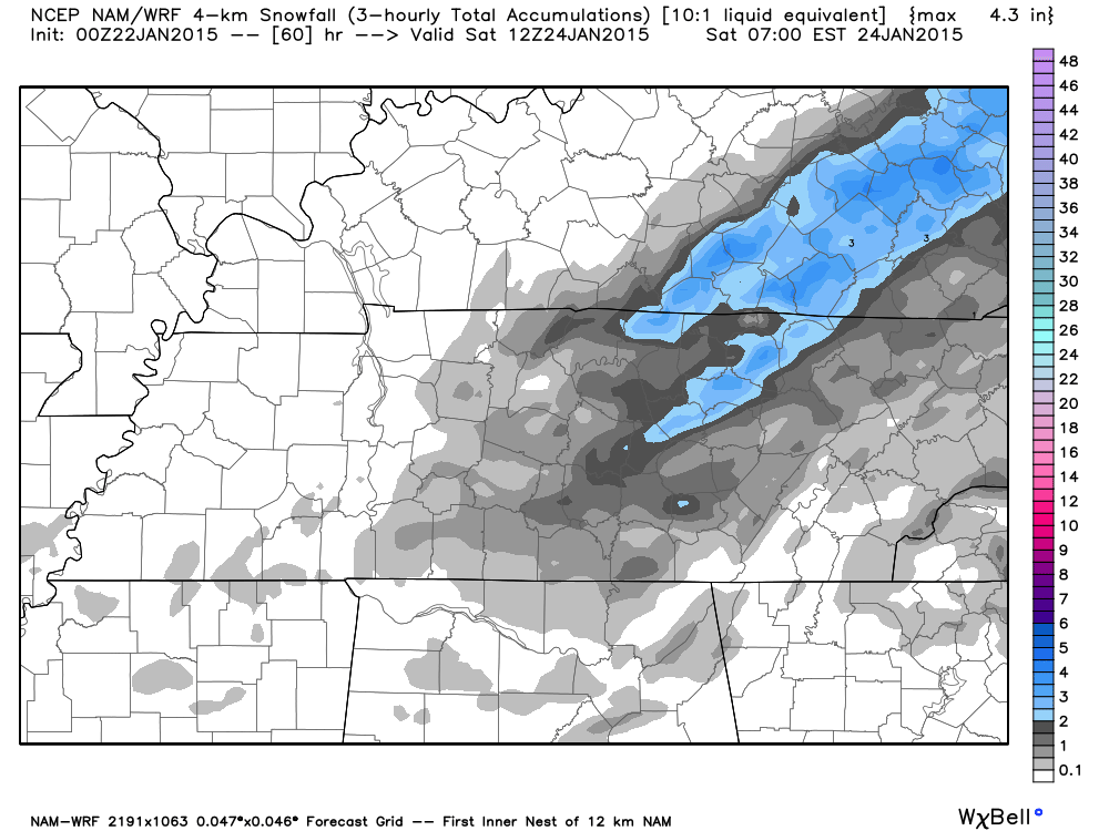
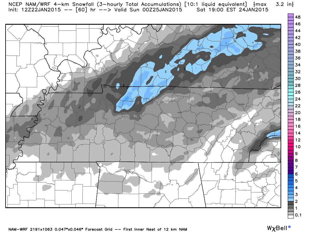
Here is the 7 am map from this morning – this is the high res NAM. It does paint some snow across west Kentucky. See how the data changes every few hours? That is what meteorologists have to figure out – which maps are correct.
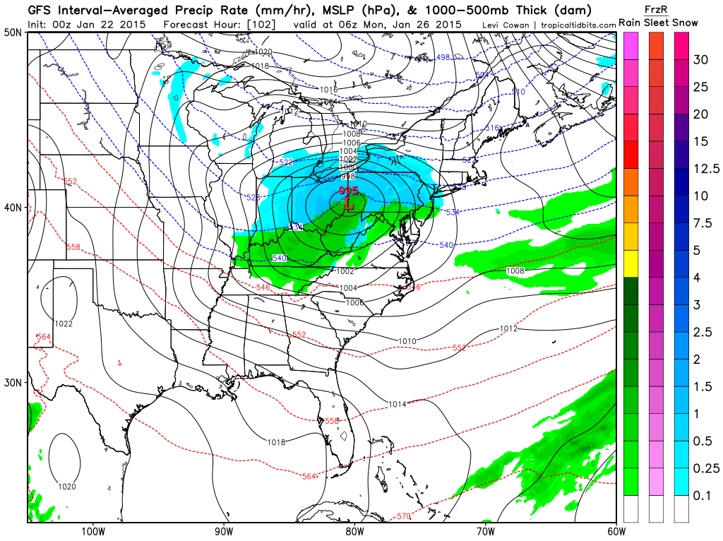
Here is the GFS model. You can see the bulk of the system misses our region.
Friday afternoon weather-map. You can see the low way to our south. Precipitation shield mainly to our south.
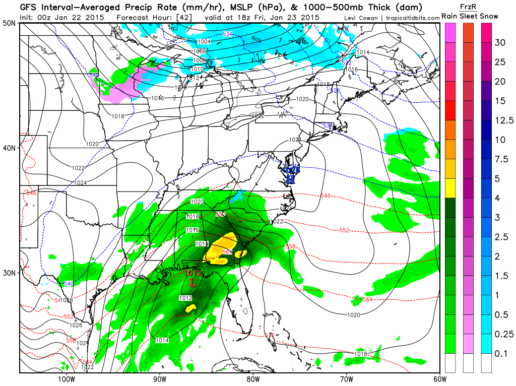
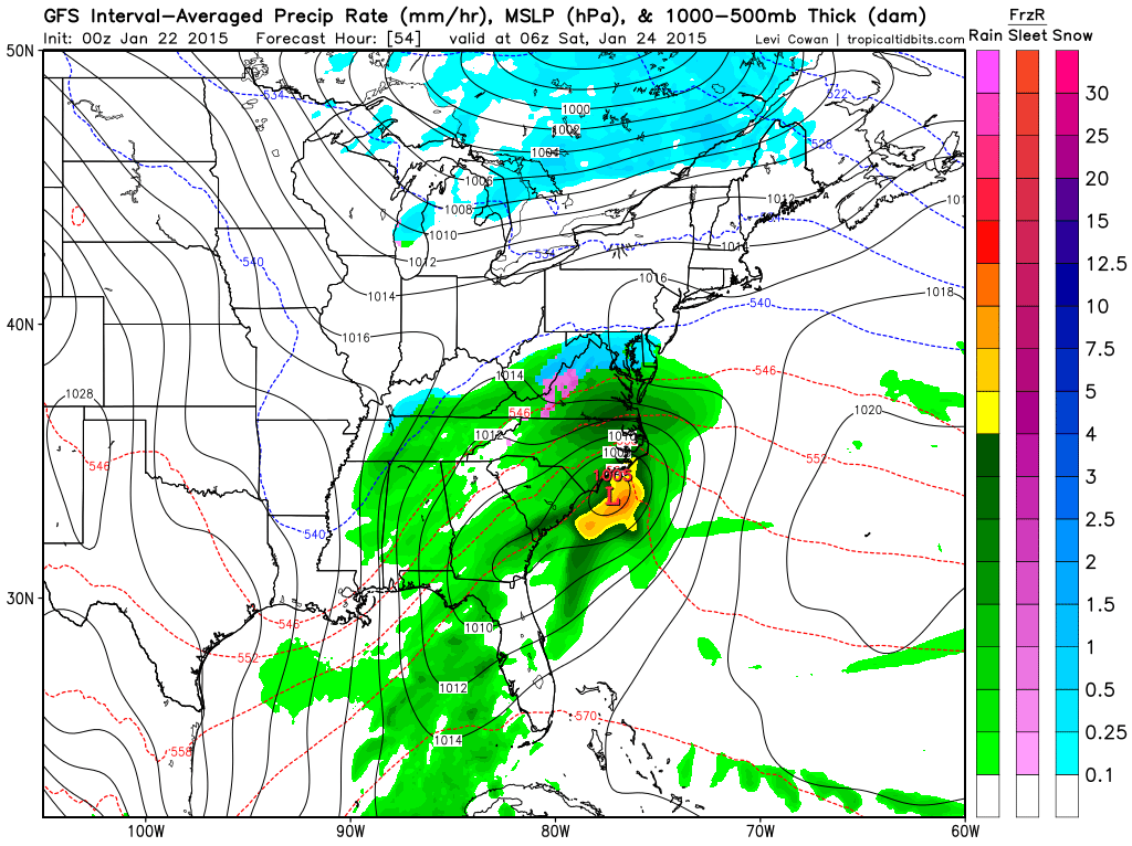
Friday evening’s weather map. You can see the storm chugging along and moving east/northeast. Some precipitation in our area. But, not a lot.
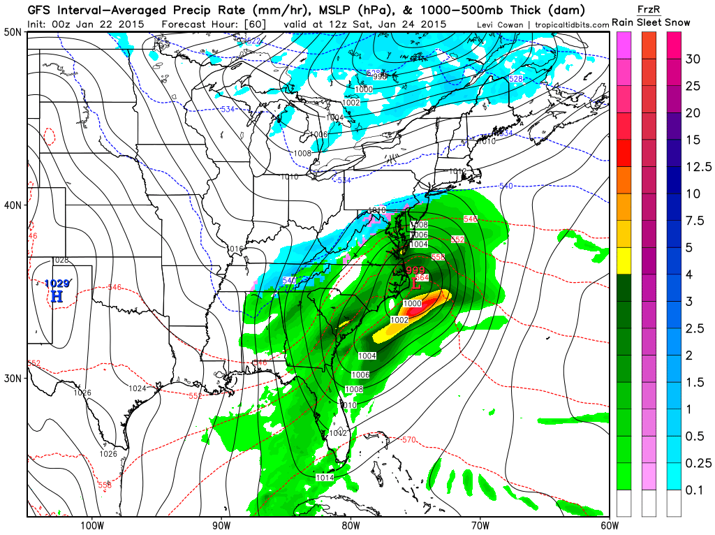
Then later on Friday night the system is pulling away. Areas along the East Coast might see quite a bit of snow.
How about the Sunday system?
The second system, that I have been tracking, will bring a chance for rain to the area on Sunday. The rain may end as light snow or flurries on Sunday night or Monday morning. Nothing significant.
Here is the forecast track for the system.
This is the Sunday afternoon weather map
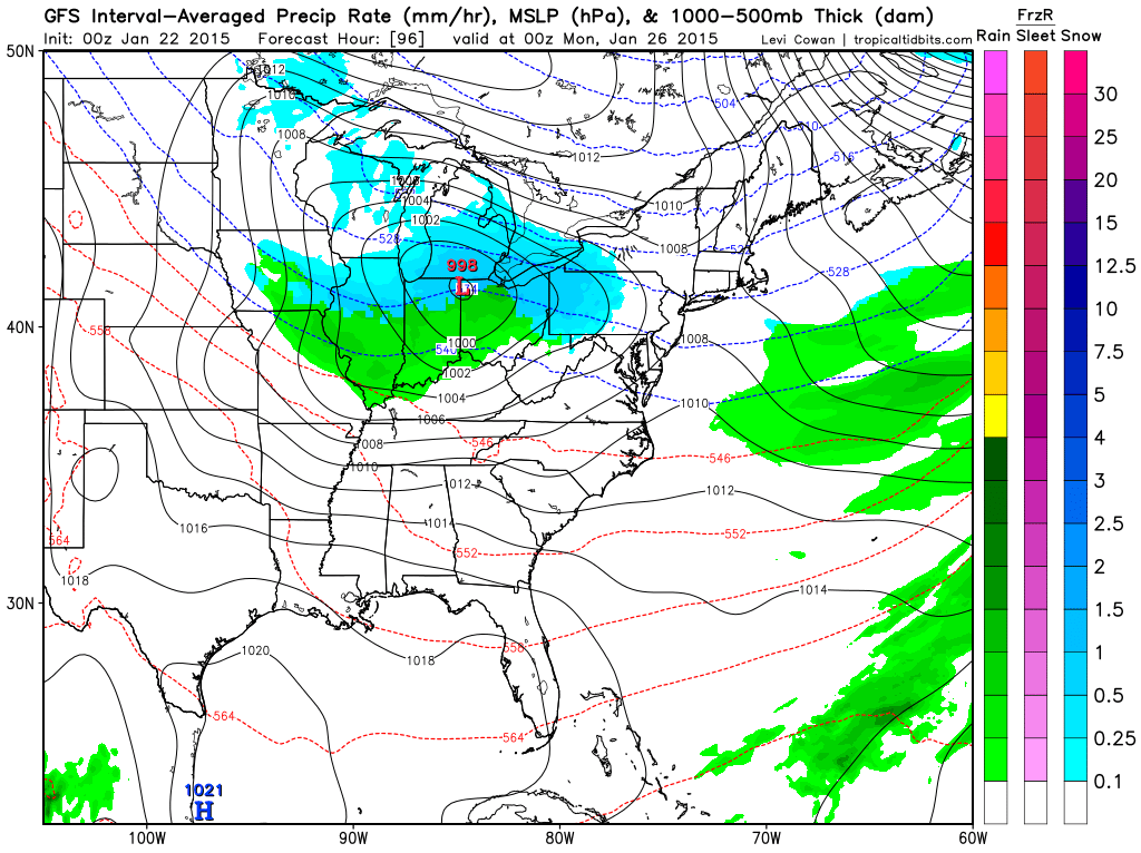
The Sunday system is going to track through Indiana. Remember the maps I have been posting from the GFS showed the low tracking more over our region. But, I told you the model was likely wrong based on the pattern. I suspected the low would track further east/northeast. That places our region in the warm sector of the system. That means rain.
Some chance for showers. Even the bulk of the rain on Sunday looks to be further east/northeast of our region.

This section of the blog is speculative forecast information. Because it is past the range of what meteorologists can forecast accurately, it should be considered speculation. Anything past day 5 is considered a long range forecast.
The long range has a colder appearance to it. I have been talking about this for awhile now. It appears that at least more seasonable temperatures will be the rule as we move into next week and the following. Some indications of a couple of sharp cold snaps mixed in, as well.
A lot of the data has backed off the big cold snap next week. Some of the data had that centered over our region. I have been centering that over the Great Lakes and New England. That appears to be where the data is now heading, as well.
There are some favorable signals for wintry precipitation as we push into late next week and the following week. If that is the case then even colder temperatures will prevail in the long range.
The ensembles indicate another southern system towards the end of next week into the first part of February.
For those of you who like to have something to watch in the long range. I guess this is what we will be watching.
They also indicate cold temperatures.

Who do you trust for your weather information and who holds them accountable?
I have studied weather in our region since the late 1970’s. I have 37 years of experience in observing our regions weather patterns. My degree is in Broadcast Meteorology from Mississippi State University and an Associate of Science (AS). I am currently working on my Bachelor’s Degree in Geoscience. Just need to finish two Spanish classes!
I am a member of the American Meteorological Society. I am a NOAA Weather-Ready Nation Ambassador. And, I am the Meteorologist for McCracken County Emergency Management.
I own and operate the Southern Illinois Weather Observatory.
There is a lot of noise on the internet. A lot of weather maps are posted without explanation. Over time you should learn who to trust for your weather information.
My forecast philosophy is simple and straight forward.
- Communicate in simple terms
- To be as accurate as possible within a reasonable time frame before an event
- Interact with you on Twitter, Facebook, and the blog
- Minimize the “hype” that you might see on television or through other weather sources
- Push you towards utilizing wall-to-wall LOCAL TV coverage during severe weather events
I am a recipient of the Mark Trail Award, WPSD Six Who Make A Difference Award, Kentucky Colonel, and the Caesar J. Fiamma” Award from the American Red Cross. In 2009 I was presented with the Kentucky Office of Highway Safety Award. I was recognized by the Kentucky House of Representatives for my service to the State of Kentucky leading up to several winter storms and severe weather outbreaks.
If you click on the image below you can read the Kentucky House of Representatives Resolution.

I am also President of the Shadow Angel Foundation which serves portions of western Kentucky and southern Illinois.

We have regional radars and local city radars – if a radar does not seem to be updating then try another one. Occasional browsers need their cache cleared. You may also try restarting your browser. That usually fixes the problem. Occasionally we do have a radar go down. That is why I have duplicates. Thus, if one fails then try another one.
If you have any problems then please send me an email beaudodson@usawx.com
WEATHER RADAR PAGE – Click here —
We also have a new national interactive radar – you can view that radar by clicking here.
Local interactive city radars include St Louis, Mt Vernon, Evansville, Poplar Bluff, Cape Girardeau, Marion, Paducah, Hopkinsville, Memphis, Nashville, Dyersburg, and all of eastern Kentucky – these are interactive radars. Local city radars – click here
NOTE: Occasionally you will see ground clutter on the radar (these are false echoes). Normally they show up close to the radar sites – including Paducah.

Regional Radar – Click on radar to take you our full radar page.


Regional Radar
![]()
Current WARNINGS (a warning means take action now). Click on your county to drill down to the latest warning information. Keep in mind that there can be a 2-3 minute delay in the updated warning information.
I strongly encourage you to use a NOAA Weather Radio or warning cell phone app for the most up to date warning information. Nothing is faster than a NOAA weather radio.


Color shaded counties are under some type of watch, warning, advisory, or special weather statement. Click your county to view the latest information.

Missouri Warnings

Illinois Warnings

Kentucky Warnings

Please visit your local National Weather Service Office by clicking here. The National Weather Service Office, for our region, is located in Paducah, Kentucky. They have a lot of maps and information on their site. Local people…local forecasters who care about our region.


Here is the official 6-10 day and 8-14 day temperature and precipitation outlook. Check the date stamp at the top of each image (so you understand the time frame).
The forecast maps below are issued by the Weather Prediction Center (NOAA).


The latest 8-14 day temperature and precipitation outlook. Note the dates are at the top of the image. These maps DO NOT tell you how high or low temperatures or precipitation will be. They simply give you the probability as to whether temperatures or precipitation will be above or below normal.


Many of my graphics are from www.weatherbell.com – a great resource for weather data, model data, and more


This blog was inspired by ABC 33/40’s Alabama Weather Blog – view their blog
Current tower cam view from the Weather Observatory- Click here for all cameras.

Southern Illinois Weather Observatory

The Weather Observatory

Southern Illinois Weather Observatory
WSIL TV 3 has a number of tower cameras. Click here for their tower camera page & Illinois Road Conditions

Marion, Illinois
WPSD TV 6 has a number of tower cameras. Click here for their tower camera page & Kentucky Road Conditions & Kentucky Highway and Interstate Cameras

Downtown Paducah, Kentucky
Benton, Kentucky Tower Camera – Click here for full view

Benton, Kentucky

I24 Paducah, Kentucky

I24 Mile Point 9 – Paducah, KY

I24 – Mile Point 3 Paducah, Kentucky

You can sign up for my AWARE email by clicking here I typically send out AWARE emails before severe weather, winter storms, or other active weather situations. I do not email watches or warnings. The emails are a basic “heads up” concerning incoming weather conditions.