
4 PM Update
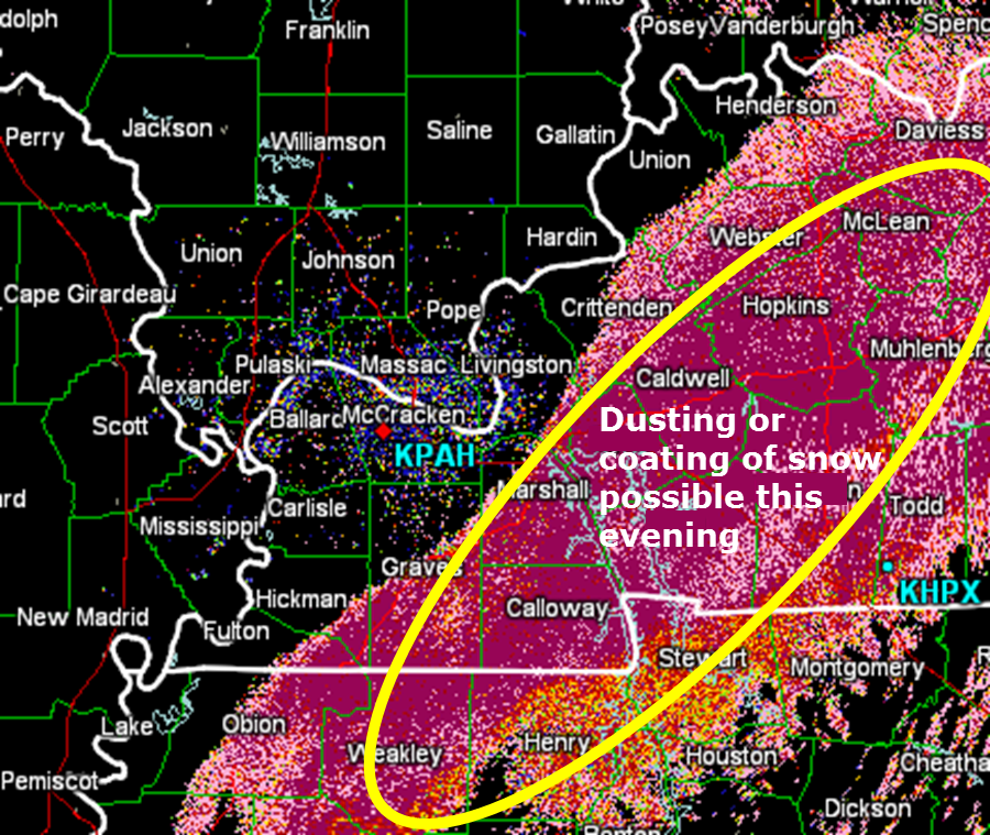
Rain and snow is coming to an end over far west KY and far southern IL.
Snow or rain/snow will continue over parts of west KY for a few more hours. There could be a quick coating of snow from the Murray, KY area – Land Between the Lakes – northeast and east from there. Temperatures will fall this evening. Thus, those areas may see some light accumulation.
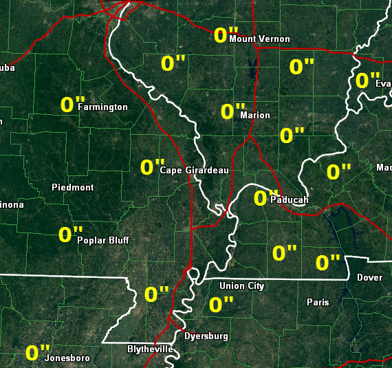
Snowfall totals as of 4 PM
We have our first sponsor for the blog. Milner and Orr Funeral Home and Cremation Services located in Paducah, Kentucky and three other western Kentucky towns – at Milner and Orr they believe in families helping families.
![]()

This forecast update covers far southern Illinois, far southeast Missouri, and far western Kentucky. See the coverage map on the right side of the blog.
Remember that weather evolves. Check back frequently for updates, especially during active weather.
Friday – Cloudy with a chance for light rain rain/snow mix. Sleet possible, as well. Flakes in the air, as I like to call them 🙂 Early during the morning we may see some light snow in areas where temperatures have not risen above freezing. High temperatures in the middle to upper 30’s – temperatures may even rise into the lower 40’s in areas outside of precipitation. North winds at 5-10 mph.
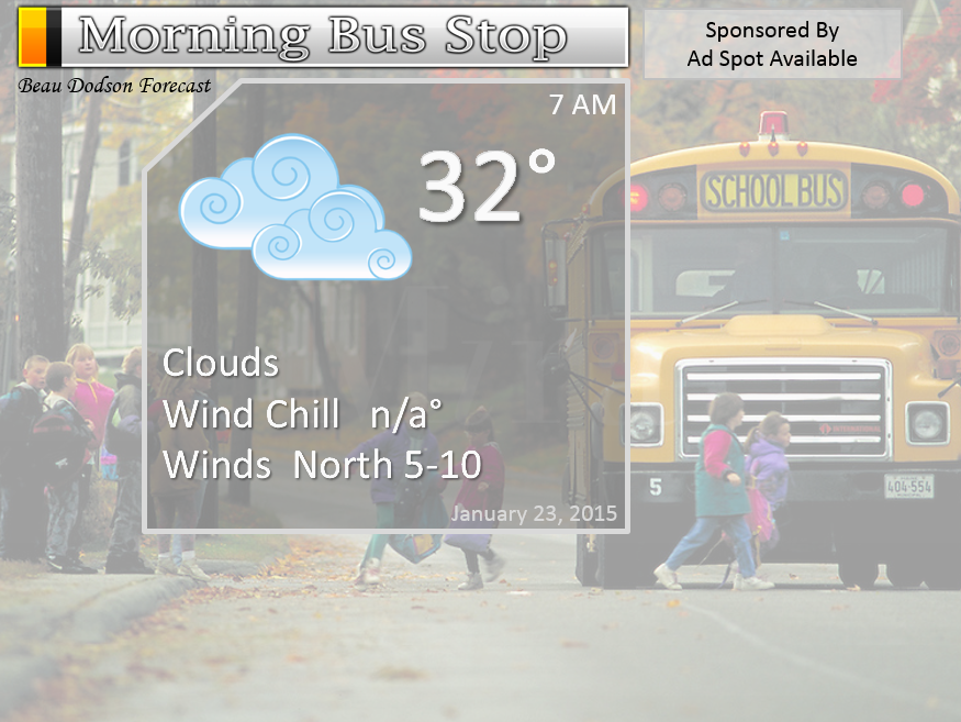
Morning School Bus Stop Weather – Cloudy with temperatures in the 30’s. A chance for some light rain or rain/snow mix. North winds at 5-10 mph
Afternoon School Bus Stop Weather – Cloudy with a chance for light rain or light rain/snow mix. Temperatures in the 30’s. North winds at 5-10 mph.
Friday night – Mostly cloudy with some light rain or snow coming to an end. Little in the way of accumulation. Low temperatures in the 20’s. North/northwest winds at 5-10 mph. Above normal temperatures.
Not expecting significant accumulation from any snow that falls. Some of the models are showing a dusting to an inch or so of snow for some of our counties. Mainly some of the western Kentucky counties. Right now temperatures should be above freezing over western Kentucky for most of Friday. Friday evening temperatures may fall a few degrees. Will monitor and update the blog today if things appear to be changing.
I call this “flakes in the air” snow
There continues to be some question on whether snow will stick around Murray over into the Land Between the Lakes and then east/northeast from there.
Saturday – Partly sunny with decent temperatures for January. Highs will be in the 40’s. West winds at 5-10 mph with gusts to 15 mph. Above normal temperatures.
Saturday night – Partly cloudy. Lows will be in the 30’s. West and southwest winds at 10 mph. Above normal temperatures.
Sunday – Mostly cloudy with a 30%-40% chance for a light shower – mainly late in the day. Windy at times. High temperatures will range from 48 to 54 degrees. Nice for January. Southwest becoming northwest winds at 10-20 mph. Above normal temperatures.

Current Temperatures Around The Local Area


An explanation of what is happening in the atmosphere over the coming days…
Well, our long awaited precipitation maker (been tracking this for 11 days now) is moving across the southern United States. Pouring rain and thunderstorms cover a large chunk of real estate to our south.
The shield of precipitation will spread northward a bit today as the area of low pressure moves along the Gulf of Mexico into the southeast United States.
WEATHER RADAR PAGE – Click here —
We also have a new national interactive radar – you can view that radar by clicking here.
Local city radars – click here
That means some light rain rain/snow mix into our region. The rain may mix with some snowflakes from time to time. Not a big deal. Not expecting any significant accumulation.
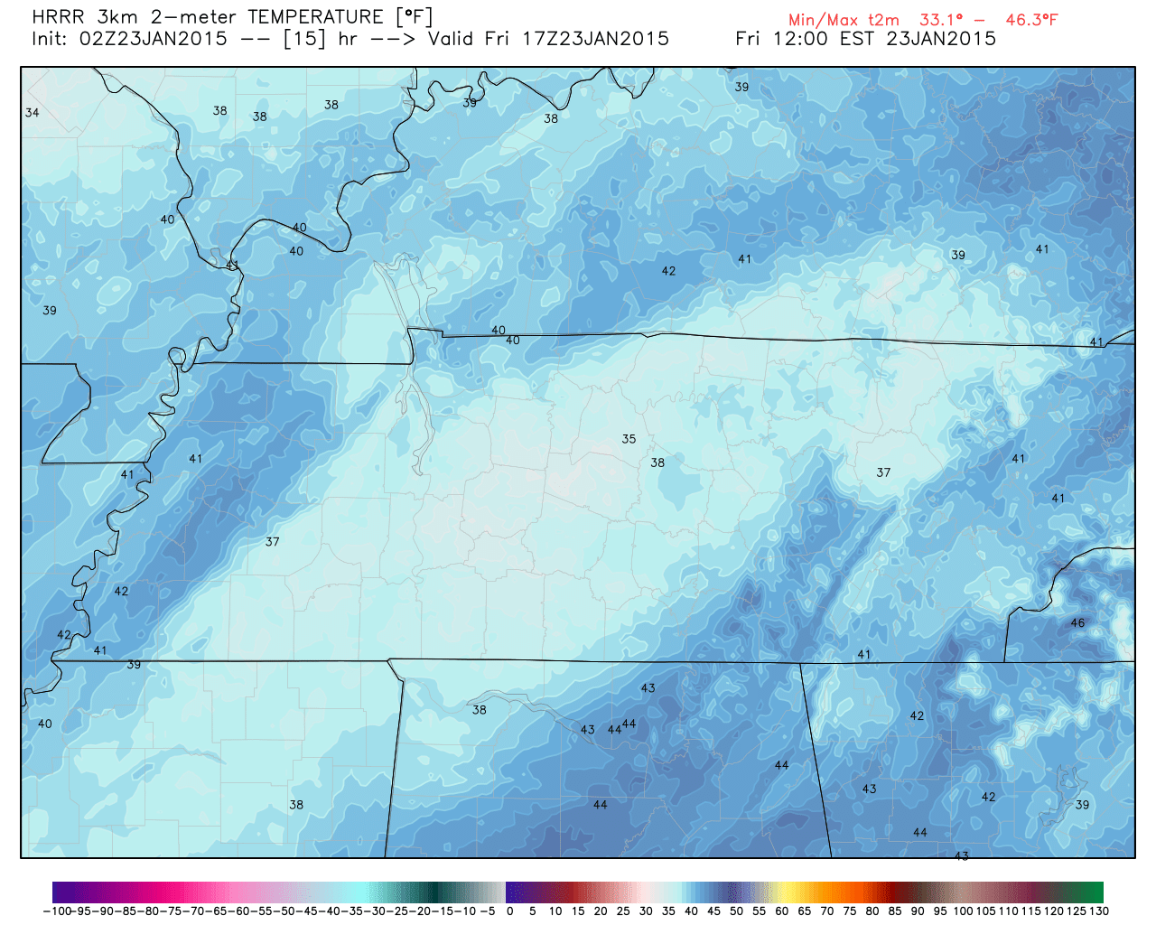
Temperatures today will be above freezing. Highs will top out around 40 degrees in most counties.
Here is the forecast temperatures for around 11 am – you can see some forties on the map
Rain will end tonight as some flurries or light snow. Perhaps the eastern counties will see a bit more light snow as the system pulls away.
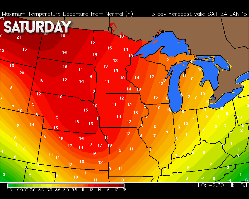
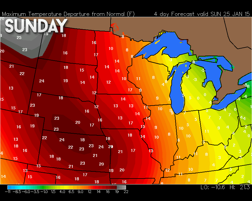
Saturday and Sunday will bring above normal temperatures.
Here are the temperature anomaly maps for Saturday and Sunday. In other words, how many degrees above normal will temperatures be? Images from wright-weather.com
And Sunday
Another weather system will dive in from Canada on Sunday. That low will track towards Indiana and Ohio. That places us on the warm side of the low. That means a few showers. The snow with that system will remain well to our northeast.
Colder air filters in on Sunday night. Maybe some flurries for parts of the area as the colder air arrives? Nothing significant. Most likely that would be our northeast counties. That would include southwest Indiana or northwest Kentucky – up towards Owensboro. Again, nothing of significance.
I knew the Sunday storm would trend northeast but yeeesh did it ever. The low is so far northeast that our region may only be clipped by rain showers. Best shower chances are closer to the low – northeast counties vs southwest counties. Any rain that falls would be light.
Here is the weatherbell.com NAM model showing that system – you can see the low well to our northeast. The blue represents light snow and the green would be rain showers.
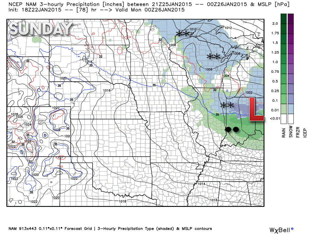
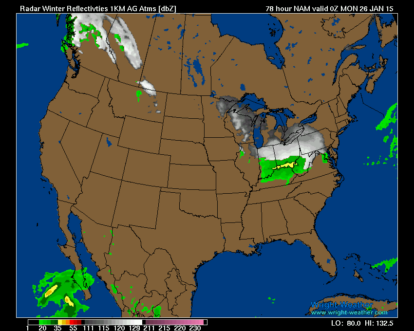
Future-cast radar for 6 pm on Sunday
You can see most of the precipitation to our northeast.
Did you know that the Weather Observatory is funded by people like you? I rely on ad’s on this blog and individual donations. PayPal also allows you to set up a monthly recurring donation. I have had several people give $5, $10, and $20 a month. A recurring donation helps keep the weather information flowing. If you enjoy this blog, the Twitter account, the Facebook interaction, the weather radars, and all of the other information then consider making a donation or setting up a recurring donation (if you don’t use PayPal then contact me through email about how you can mail a donation) beaudodson@usawx.com
Thank you for your support!

No big changes. Still mentioned the snow possibility for a few counties.

Main concern will be the chance for some light snow later today or tonight – mainly over our eastern counties. Temperatures today will rise above freezing. In order for some snow to develop we are going to have to see those temperatures fall a bit later this afternoon and tonight.
If the rain does change to snow then a dusting might occur in a few spots (eastern and southeastern counties – that would be areas such as the Land Between the Lakes and then northeast/eastward.
Use care if precipitation does develop and a brief period of snow occurs. Temperatures are starting out around freezing this morning.
Also if moisture remains on the roads tonight then that could also freeze in a few spots.
Check out our newest sponsors $5 meal! The DQ Grill and Chill (located across from Noble Park in Paducah, Kentucky) is the newest WeatherTalk Blog sponsor! A local business helping to sponsor the weather information that you have come to love so much.
They have a Facebook Page and I encourage you to check it out. DQ Grill and Chill on Facebook

 The wild card tells you where the uncertainties are in the forecast
Wild card in this forecast – The wild card today will be whether some of us will actually see some snowflakes.

Can we expect severe thunderstorms over the next 24 to 48 hours? Remember that a severe thunderstorm is defined as a thunderstorm that produces 58 mph winds or higher, quarter size hail or larger, and/or a tornado.
Thunderstorm threat level is ZERO
![]()
Current WATCHES/WARNINGS


Will I need to take action?
Some umbrellas today and then monitor and changes to the snow part of the forecast. Right now this appears to mainly be a rain event. Still a small chance that our eastern/southeastern counties might end up with some light snow at the end of the system.
If you are traveling east then monitor updates if you have concerns.

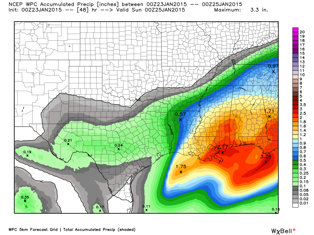
How much precipitation should we expect over the next few days?
Light rain today – rain may be a rain/snow mix at times.
Precipitation forecast through Friday night.
We have a new sponsor! G&C Multi-Services out of Paducah, Kentucky. G & C Multi-Services is a service provider in Western Kentucky that provides industrial and commercial equipment fabrication, machine troubleshooting, repair and maintenance, and installation. They can custom fabricate steel, stainless, and aluminum products per customer specifications.
Visit their web-site here. Or click the ad below! They have a Facebook page and it can be viewed here.


Other than today’s precipitation event, nothing of interest is showing up in the short-range charts.
I am watching a clipper towards the middle of the new work week. Clippers dive down from Canada and typically track through Illinois, Indiana, and Ohio. Sometimes they track far enough south to give us some precipitation, as well.
I am watching the very end of January into the first part of February for a system.

This section of the blog is speculative forecast information. Because it is past the range of what meteorologists can forecast accurately, it should be considered speculation. Anything past day 5 is considered a long range forecast.
Well, I was losing faith over the past week about the long advertised cold blast next week. A lot of national forecasters had this cold snap centered over our region. My thoughts were that it would be centered more to the northeast and east.
All of the data has now pushed towards my forecast thoughts. The center of the cold is going to be centered over the Great Lakes and the northeast (even east).
We will cool down some next week, but it isn’t anything extreme.
Let’s take a look at the GFS model anomalies for Paducah, Kentucky – the orange indicates above normal temps and the blue indicates below normal temperatures. You can see the dates at the bottom of the graph.
You can see the GFS likes my idea of below normal temperatures towards the very end of the month into early February.
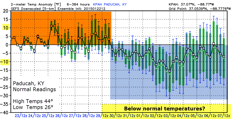
The better chances for colder air may wait until the first part of February. I am also still monitoring a storm system for the first part of February. Most of the ensembles and tele-connections are pointing towards some sort of event around that time for the United States. Event meaning a storm system to track.
The data points towards a southern storm track. But, how far south? As always in the long range there isn’t a real forecast. There are only items of interest to monitor as we move forward.
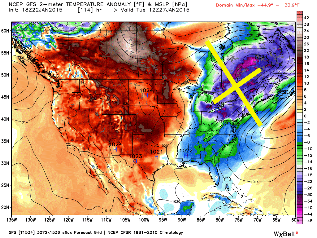
Let’s take a look at the temperature anomaly maps for next week.
This first map is for today through January 27th (see how the cold is centered over the Great Lakes and the northeast)
Perhaps we will see some colder shots of air at the beginning of February. All signs are pointing that way and I am more on-board for that idea.
I am watching another clipper system, as well. That one may be towards the middle of the new work week. We will have to see how far south that one tracks. Clippers dive down from Canada. Like the one showing up on the charts for Sunday afternoon.

Who do you trust for your weather information and who holds them accountable?
I have studied weather in our region since the late 1970’s. I have 37 years of experience in observing our regions weather patterns. My degree is in Broadcast Meteorology from Mississippi State University and an Associate of Science (AS). I am currently working on my Bachelor’s Degree in Geoscience. Just need to finish two Spanish classes!
I am a member of the American Meteorological Society. I am a NOAA Weather-Ready Nation Ambassador. And, I am the Meteorologist for McCracken County Emergency Management.
I own and operate the Southern Illinois Weather Observatory.
There is a lot of noise on the internet. A lot of weather maps are posted without explanation. Over time you should learn who to trust for your weather information.
My forecast philosophy is simple and straight forward.
- Communicate in simple terms
- To be as accurate as possible within a reasonable time frame before an event
- Interact with you on Twitter, Facebook, and the blog
- Minimize the “hype” that you might see on television or through other weather sources
- Push you towards utilizing wall-to-wall LOCAL TV coverage during severe weather events
I am a recipient of the Mark Trail Award, WPSD Six Who Make A Difference Award, Kentucky Colonel, and the Caesar J. Fiamma” Award from the American Red Cross. In 2009 I was presented with the Kentucky Office of Highway Safety Award. I was recognized by the Kentucky House of Representatives for my service to the State of Kentucky leading up to several winter storms and severe weather outbreaks.
If you click on the image below you can read the Kentucky House of Representatives Resolution.

I am also President of the Shadow Angel Foundation which serves portions of western Kentucky and southern Illinois.

We have regional radars and local city radars – if a radar does not seem to be updating then try another one. Occasional browsers need their cache cleared. You may also try restarting your browser. That usually fixes the problem. Occasionally we do have a radar go down. That is why I have duplicates. Thus, if one fails then try another one.
If you have any problems then please send me an email beaudodson@usawx.com
WEATHER RADAR PAGE – Click here —
We also have a new national interactive radar – you can view that radar by clicking here.
Local interactive city radars include St Louis, Mt Vernon, Evansville, Poplar Bluff, Cape Girardeau, Marion, Paducah, Hopkinsville, Memphis, Nashville, Dyersburg, and all of eastern Kentucky – these are interactive radars. Local city radars – click here
NOTE: Occasionally you will see ground clutter on the radar (these are false echoes). Normally they show up close to the radar sites – including Paducah.

Regional Radar – Click on radar to take you our full radar page.


Regional Radar

Please visit your local National Weather Service Office by clicking here. The National Weather Service Office, for our region, is located in Paducah, Kentucky. They have a lot of maps and information on their site. Local people…local forecasters who care about our region.


Here is the official 6-10 day and 8-14 day temperature and precipitation outlook. Check the date stamp at the top of each image (so you understand the time frame).
The forecast maps below are issued by the Weather Prediction Center (NOAA).


The latest 8-14 day temperature and precipitation outlook. Note the dates are at the top of the image. These maps DO NOT tell you how high or low temperatures or precipitation will be. They simply give you the probability as to whether temperatures or precipitation will be above or below normal.


Many of my graphics are from www.weatherbell.com – a great resource for weather data, model data, and more


This blog was inspired by ABC 33/40’s Alabama Weather Blog – view their blog
Current tower cam view from the Weather Observatory- Click here for all cameras.

Southern Illinois Weather Observatory

The Weather Observatory

Southern Illinois Weather Observatory
WSIL TV 3 has a number of tower cameras. Click here for their tower camera page & Illinois Road Conditions

Marion, Illinois
WPSD TV 6 has a number of tower cameras. Click here for their tower camera page & Kentucky Road Conditions & Kentucky Highway and Interstate Cameras

Downtown Paducah, Kentucky
Benton, Kentucky Tower Camera – Click here for full view

Benton, Kentucky

I24 Paducah, Kentucky

I24 Mile Point 9 – Paducah, KY

I24 – Mile Point 3 Paducah, Kentucky

You can sign up for my AWARE email by clicking here I typically send out AWARE emails before severe weather, winter storms, or other active weather situations. I do not email watches or warnings. The emails are a basic “heads up” concerning incoming weather conditions.