12 PM
Maps have been updated
8 AM UPDATE
All data overnight continues to push the Friday system further west and northwest. That means accumulating snow is possible over portions of our region. I will post updated maps once they arrive.
We have our first sponsor for the blog. Milner and Orr Funeral Home and Cremation Services located in Paducah, Kentucky and three other western Kentucky towns – at Milner and Orr they believe in families helping families.
![]()

This forecast update covers far southern Illinois, far southeast Missouri, and far western Kentucky. See the coverage map on the right side of the blog.
Remember that weather evolves. Check back frequently for updates, especially during active weather.
I will update the blog once or twice today – mainly to cover any changes on the Friday system.
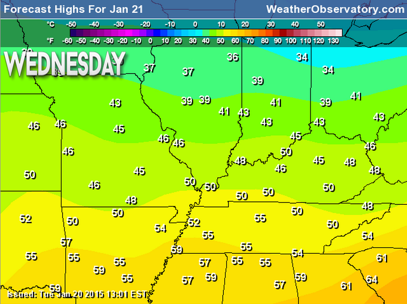
Wednesday – Partly sunny in the morning and mostly sunny in the afternoon. High temperatures will be in the upper 40’s to lower 50’s. West winds at 5-10 mph. Winds may be gusty during the late morning and afternoon hours. Gusts of 15-20 mph.
Morning School Bus Stop Weather – Partly sunny and cool. Temperatures will be in the lower to middle 30’s. West winds – light.
Afternoon School Bus Stop Weather – Mostly sunny with above normal temperatures. Temperatures will be in the upper 40’s to lower 50’s. Winds from the west/northwest at 10-15 mph.
Wednesday night – Partly to mostly cloudy. Cool. Low temperatures in the upper 20’s to lower 30’s. North winds at 5 mph.
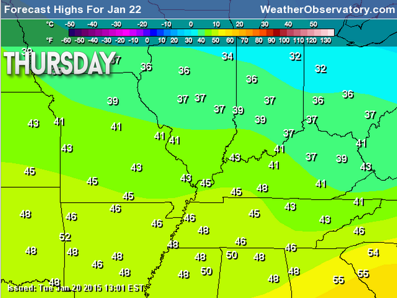
Thursday – Some clouds. High temperatures will be in the 40’s. North winds at 5-10 mph.
Thursday night – Mostly cloudy and cool. Low temperatures will be in the 20’s with north winds at 5-10 mph.
Friday – Mostly cloudy and cool. A chance for rain or snow. Some snow accumulation possible. High temperatures will be in the upper 30’s to lower 40’s. North winds at 5-10 mph.

Current Temperatures Around The Local Area


An explanation of what is happening in the atmosphere over the coming days…
Weather Highlights
- Calm today
- Perhaps a chance for precipitation on Friday (rain/snow)
- Watching Sunday’s clipper system for precipitation
- Colder next week, but nothing extreme
Another calm weather day is on tap for the region. Temperatures will again be above normal. Not too bad for January.
See the winter weather discussion (further down in the blog update) for details on a system tracking to our south on Friday. This storm may bring snow into our region. Accumulating snow.
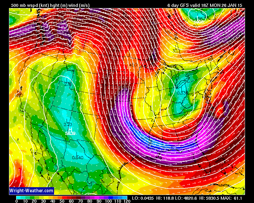
The upper air pattern will shift towards a trough over the coming weekend into early next week. That means colder temperatures and perhaps unsettled weather for Sunday. But, nothing too extreme.
Over the past week or two it appears we might see some very cold air next week. A lot of the data is pushing away from that idea and more towards colder than normal, but not extreme. I have been forecasting the center of the cold air to be more over the Great Lakes and the northeast United States. We will see how it goes (see extended discussion further down in today’s journal update)
Let’s take a look at the trough developing for the weekend into early next week…
A trough is when the jet stream dives south and east through our region. Typically that means colder weather in the winter. Let’s look at that on the 500 mb map (winds thousands of feet aloft)
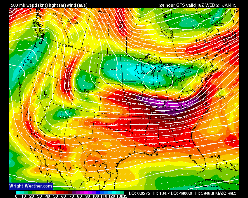
Today’s 500 mb shows a more west to east appearance to the wind field
The colors represent wind speed – see how the lines and colors appear to move from left to right (west to east)
Images are from www.wright-weather.com
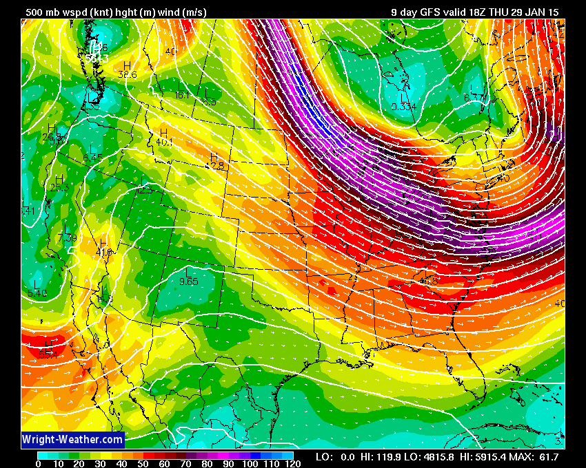
Now let’s take a look at the 500 mb wind speed map for Sunday. Notice how it is starting to change?
The jet stream is diving in from the northwest. That means colder air and unsettled.

Let’s look ahead to next week. Again, notice how the jet stream is diving in from the northwest? That means odd favors cooler temperatures than this past week. But, still nothing too extreme.
Let’s take a look at temperatures for the next few days. These temperatures will be above normal.
High temperature today through Friday
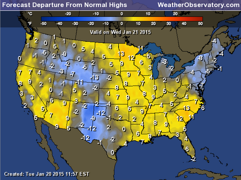
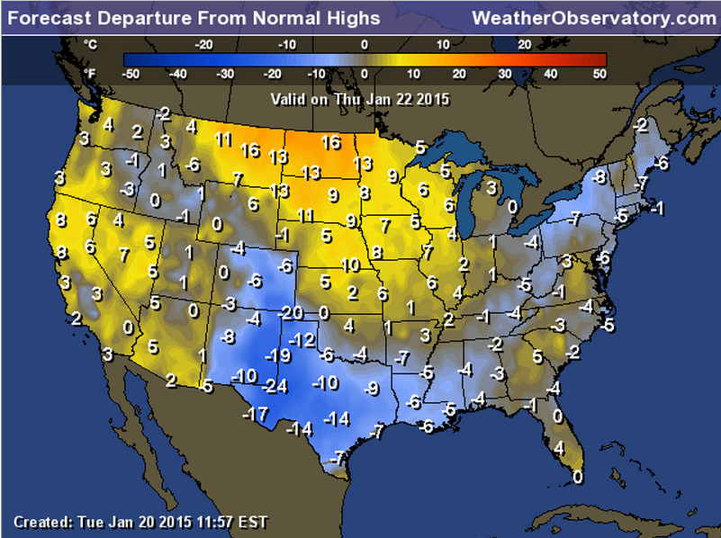
How about the anomalies? How many degrees above or below normal will temperatures be over the coming days?
Normal Temperatures
Normal High Temperature for this time of the year is 43 degrees
Normal Low Temperature for this time of the year is 26 degrees
Wednesday departures
Thursday departures
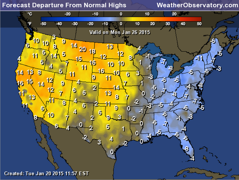
Next week we should see below normal temperatures. Here is the Monday departure map. Nothing extreme, but colder air than we have experienced over the last week or so.
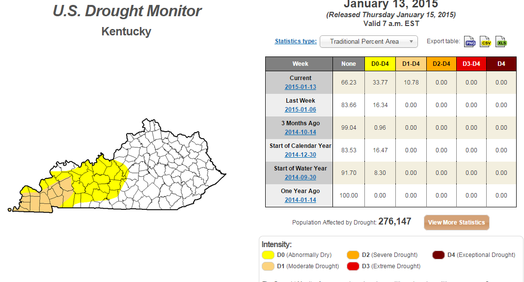
Is a drought developing?
Portions of our region are drier than normal. I know it might not feel like it, but the numbers are indicating abnormally dry weather for parts of western Kentucky. Moderate drought conditions are occurring over parts of western Kentucky and western Tennessee, as well.
Here is the latest drought monitor maps.
Click the image for a larger view
Here is the national drought monitor map
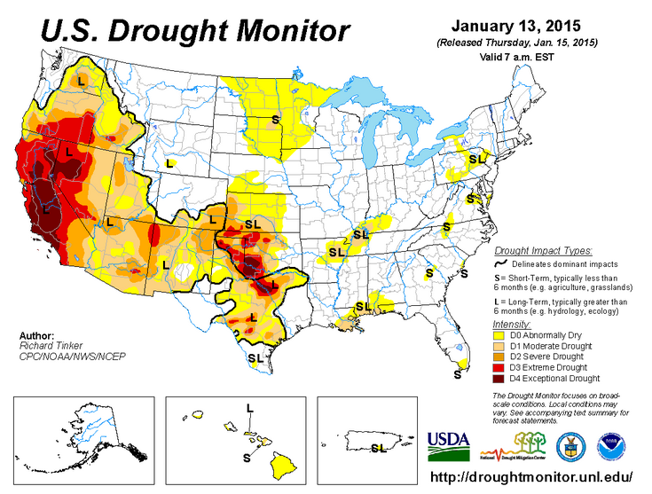
We will have to see what the coming 4-8 weeks bring to the region. My winter forecast was for colder than normal temperatures and drier than normal conditions.
Did you know that the Weather Observatory is funded by people like you? I rely on ad’s on this blog and individual donations. PayPal also allows you to set up a monthly recurring donation. I have had several people give $5, $10, and $20 a month. A recurring donation helps keep the weather information flowing. If you enjoy this blog, the Twitter account, the Facebook interaction, the weather radars, and all of the other information then consider making a donation or setting up a recurring donation (if you don’t use PayPal then contact me through email about how you can mail a donation) beaudodson@usawx.com
Thank you for your support!

Adding snow to Friday’s forecast. Some accumulation possible.

No concerns for today or Thursday. I am watching a system that should track to our south on Friday. However, data has shifted northward just a tad. See the winter forecast discussion below.
Check out our newest sponsors $5 meal! The DQ Grill and Chill (located across from Noble Park in Paducah, Kentucky) is the newest WeatherTalk Blog sponsor! A local business helping to sponsor the weather information that you have come to love so much.
They have a Facebook Page and I encourage you to check it out. DQ Grill and Chill on Facebook


The wild card tells you where the uncertainties are in the forecast
Wild card in this forecast – the wild on this forecast update will center around the chance for some precipitation on Friday into Friday evening as a low tracks well to our south. The data has shifted a bit further north. Snow may move into parts of our region late Thursday night into Friday night.

Can we expect severe thunderstorms over the next 24 to 48 hours? Remember that a severe thunderstorm is defined as a thunderstorm that produces 58 mph winds or higher, quarter size hail or larger, and/or a tornado.
Thunderstorm threat level is ZERO


Will I need to take action?
No action today. A calm weather day

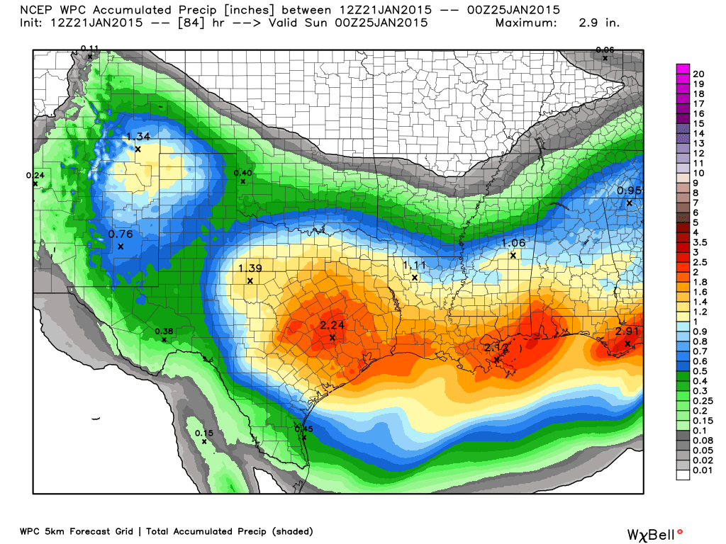
How much precipitation should we expect over the next few days?
Tracking a system for Friday and Friday night. Some precipitation could push into our region. Low confidence on this happening because the storm is so far south. The models have been trending further north.
Here is the official precipitation forecast map through Saturday night. See how the system clips our region?
Let’s see if this thing continues to shift north and west
We have a new sponsor! G&C Multi-Services out of Paducah, Kentucky. G & C Multi-Services is a service provider in Western Kentucky that provides industrial and commercial equipment fabrication, machine troubleshooting, repair and maintenance, and installation. They can custom fabricate steel, stainless, and aluminum products per customer specifications.
Visit their web-site here. Or click the ad below! They have a Facebook page and it can be viewed here.


I am currently watching a couple of precipitation makers. Our southern system (that I have been tracking for the last 10 days) is starting to shift slightly further north. If this does indeed occur then I will have to introduce some precipitation chances for Thursday night into Friday. Right now temperatures are borderline for rain vs snow.
System One – Thursday night into Friday evening
- System is forecast to track way south and may not impact our region at all
- The models have trended a bit further north with the area of low pressure and precipitation shield
- If the low tracks far enough north then there could be some rain/snow move into parts of our region. Some accumulating snow would be possible.
- Currently it appears there is at least a chance that this system brings precipitation into our region
- Monitor updates because if it trends further north then precip would likely occur in our region
Details:
Earlier in the week it appeared an area of low pressure would track so far south that all of the precipitation would remain out of our region. However, over the past day or two there has been a slow shift northward of both the area of low pressure and the precipitation shield. Still low confidence on the exact track of the low.
Right now it appears the low will hug the Gulf of Mexico – perhaps moving from Texas into the Florida Panhandle – maybe a little north of there. The EC model takes it into Alabama (further north). If that is the case then chances for precipitation in our region would increase quite a bit.
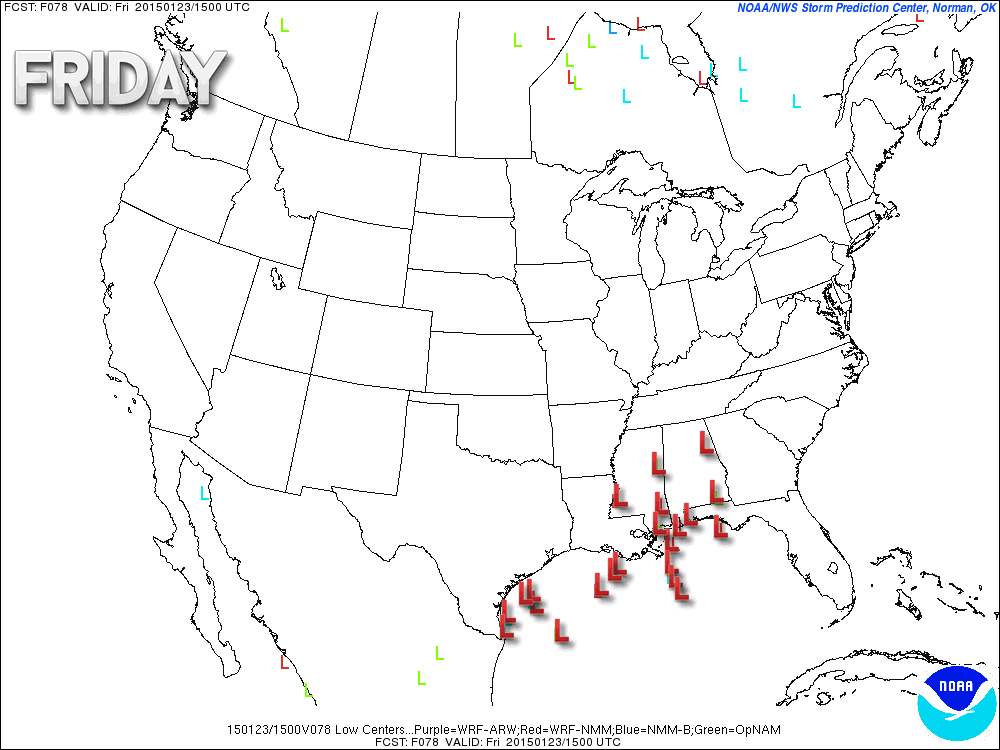
The SREF ensemble model is showing where the low might track. You see all the lows (L’s)? Those are different model runs showing where the low should track. The more tightly clustered the lows are…the higher confidence in the position of the area of low pressure. There is still quite a spread on the data.
The tightest cluster is around the Florida Panhandle. Again, this is the SREF model’s idea. The EC is further north with the track. This will need to be monitored.
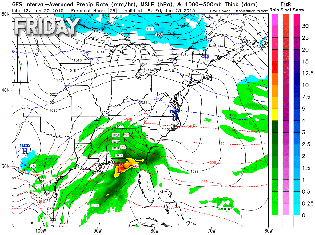
Let’s take a look at this system on the GFS model.
This is the weather map on Friday. You can see the large precipitation shield along the Gulf of Mexico. Lot of rain and thunderstorms. Heavy at times.
You can see hints of precipitation trying to develop further north in Arkansas into Tennessee. This is what we will need to monitor. Again, a wait and see approach on the exact track of the area of low pressure. Since it has been trending northward a bit.
Images are from www.weatherbell.com
The next map is for Friday evening. You can see the bulk of the precipitation well to our south and east. But, some precipitation near our region. Any further shift northward and our forecast will change considerably.
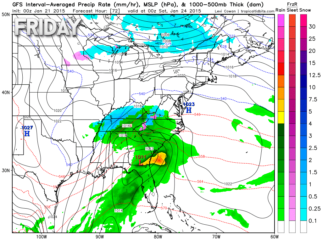
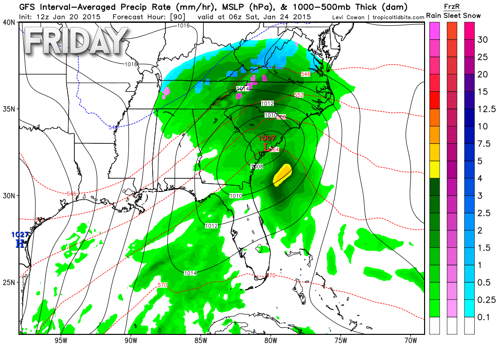
Let’s move ahead to late Friday night into Saturday morning. The area of low pressure is pulling away over the southeast United States. You can see rain/snow over central and eastern Kentucky. That area if more likely to see some impact from this system.
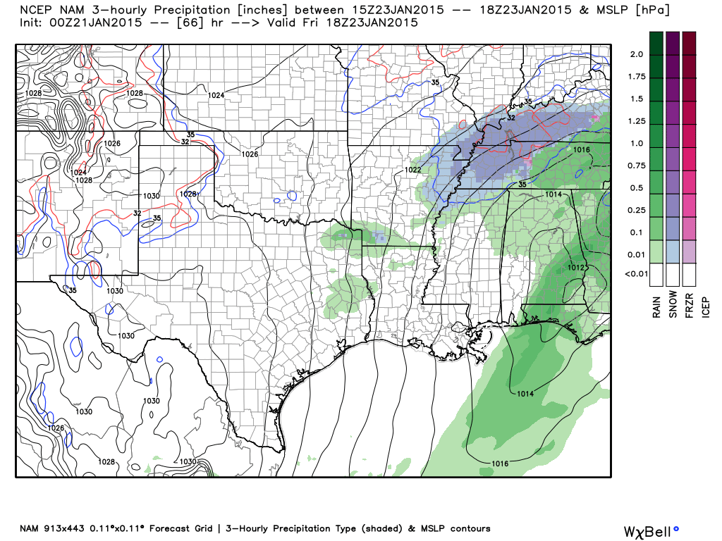
Here is the NAM model – it brings the precipitation into our region. So, keep this in mind – there are differing model opinions on where this storm tracks.
If precipitation were to develop then it would be on Friday/Friday evening. The highest probability of precipitation would be over our southern counties (since this is a southern track storm system).
This map will likely change a couple of times…but for now this is the favored area
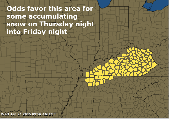
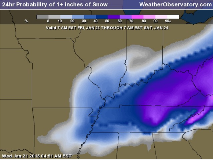
What you are viewing is the probability of 1″ of snow. This map will be updated several times between now and Friday. So, let’s keep an eye on it.
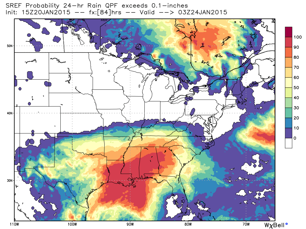
Let’s take a look at one more weather map. This is the SREF model (ensembles). What is the probability of 0.10″+ of precipitation falling with this system?
You can see the SREF does paint at least chances of that happening into our region.
System Two – Sunday
- A clipper system moves in from Canada and tracks southeast towards Illinois/Indiana
- Track of the system will be key to what happens in our region
- Rain or rain/snow appears likely on Sunday/Sunday night as the low moves through the region
Details…
The second system to monitor will be our little area of low pressure that is going to dive out of Canada and the Northern Plains on Sunday. This low will quickly track southeast into the Ohio Valley. Precipitation will develop along the path of the low.
Right now it appears the low will track to our northeast. If this is the case then the bulk of our precipitation will be rain. If the low were to track further southwest then that would open the door to snow for our local counties.
Remember that if you want snow then you want the low to track south of you.
As it stands right now it appears the best chance of snow will be to our northeast. Monitor updates in case the path of the area of low pressure shifts.
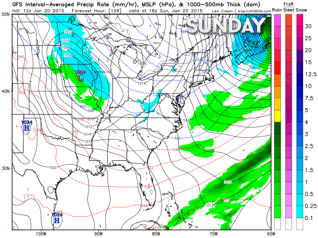
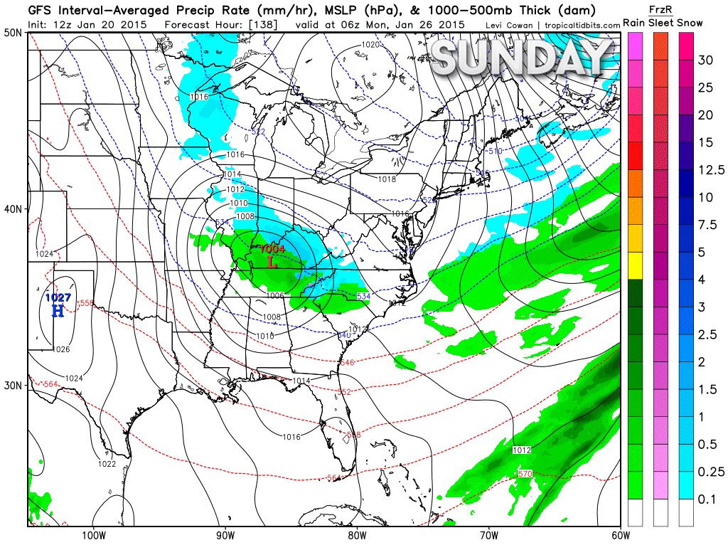
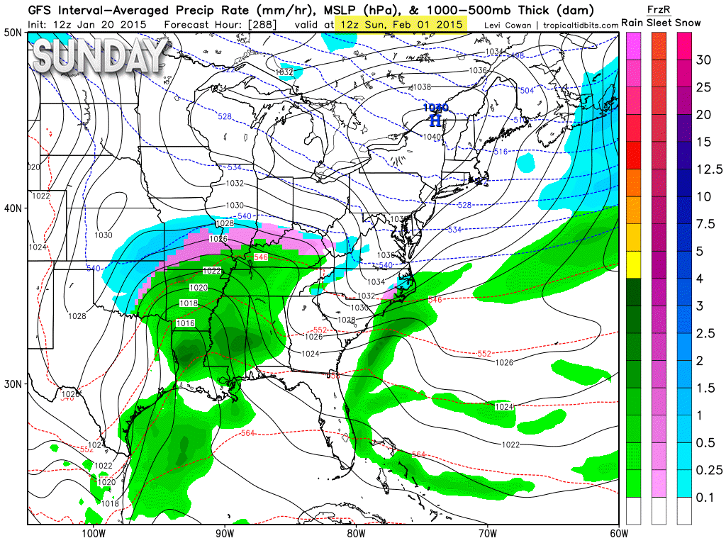
Let’s take a look at the weather maps for our clipper. This map is for Sunday afternoon. You can see the low over Iowa. The blue colors represent snow and the green would be rain. The low is moving southeast.
The speed of the low is still in question. The EC model is a bit faster with the low. Either way – some rain is forecast to develop on Sunday over our region. Light rain.
Images are from www.weatherbell.com
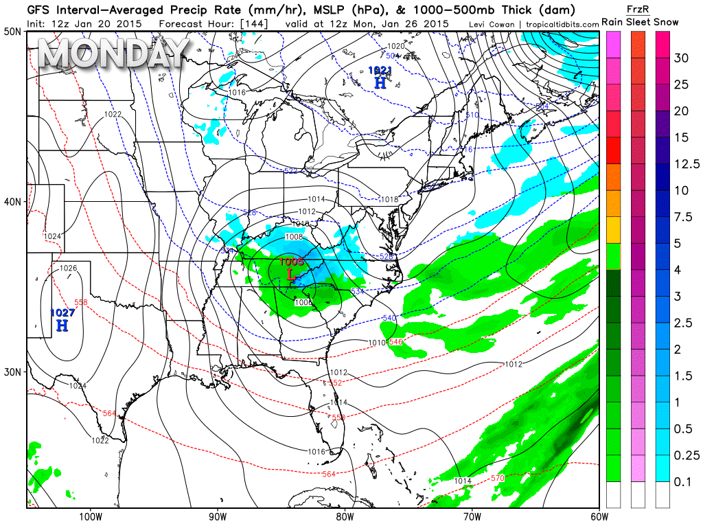
Here is the map for Sunday night around 11 pm to 1 am. You can see the area of low pressure has quickly moved southeast. The low is now centered over western/central Kentucky. This is the GFS model depiction of how the system unfolds. I believe the low will actually track a bit further northeast. The ensemble models (a bunch of models) indicate the track should be through Indiana and then central/eastern Kentucky.
You can see that precipitation continues on Sunday night in our region. Mostly rain, but perhaps a rain/snow mix for some of our counties. That would be more likely over the northeast portion of the region.
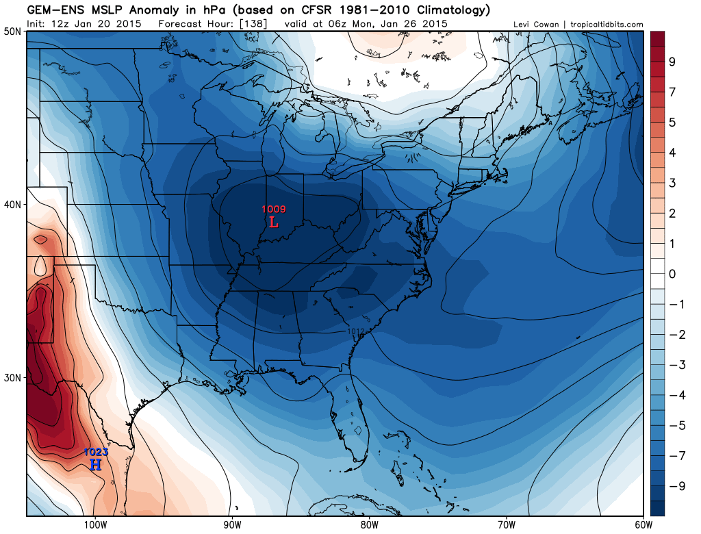
And finally – this is the weather map for early Monday morning. You can see the low is pulling away from our region. That will leave us with colder air. Maybe some flurries or light snow showers? We will see.
Here is the GEM/Canadian model. It takes the low into Indiana – which makes some sense based on the pattern.
GFS has been furthest south and west with the track of the low.

This section of the blog is speculative forecast information. Because it is past the range of what meteorologists can forecast accurately, it should be considered speculation. Anything past day 5 is considered a long range forecast.
The extended forecast continues to indicate a cold spell for next week into the first part of February. Still a lot of debate as to how cold it will be. I have been forecasting the core of the cold to be centered further north and east of our region vs over our region.
The Canadian model agrees with me on this subject. Here is what it showing for the next 2 weeks. You can see the blue to our northeast. That is where the temperature are mostly below normal. Above normal temperatures to our west. That leaves us in the normal to below normal range.
Other data shows much colder air over our region. This has been a topic of discussion here on the journal for the past week. At this point I will stick with colder than normal readings next week, but nothing extreme.
What about precipitation?
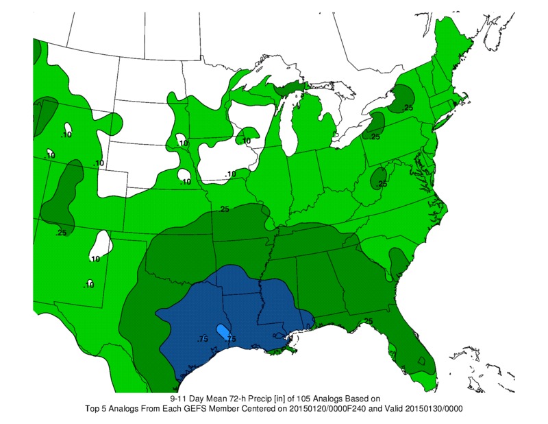
There are some indications that another southern track storm will develop next week. Here is what the GFS is showing
This is for February 1st/2nd/3rd (lala land for model data – that means it is simply something to watch as we move forward).
Will there be a system next weekend? The GFS model thinks so. Image is from www.weatherbell.com
The ensembles do favor a southern track storm next week.
Ensemble forecasts?
Instead of running just a single forecast, the computer model is run a number of times from slightly different starting conditions. The complete set of forecasts is referred to as the ensemble, and individual forecasts within it as ensemble members. We design the ensemble forecast system so that each member should be equally likely. The initial differences between the ensemble members are small, and consistent with uncertainties in the observations. But when we look several days ahead the forecasts can be quite different.
You can see a lot of green painted on this map for later next week. That basically means that the models are picking up on the potential for a precipitation event

Who do you trust for your weather information and who holds them accountable?
I have studied weather in our region since the late 1970’s. I have 37 years of experience in observing our regions weather patterns. My degree is in Broadcast Meteorology from Mississippi State University and an Associate of Science (AS). I am currently working on my Bachelor’s Degree in Geoscience. Just need to finish two Spanish classes!
I am a member of the American Meteorological Society. I am a NOAA Weather-Ready Nation Ambassador. And, I am the Meteorologist for McCracken County Emergency Management.
I own and operate the Southern Illinois Weather Observatory.
There is a lot of noise on the internet. A lot of weather maps are posted without explanation. Over time you should learn who to trust for your weather information.
My forecast philosophy is simple and straight forward.
- Communicate in simple terms
- To be as accurate as possible within a reasonable time frame before an event
- Interact with you on Twitter, Facebook, and the blog
- Minimize the “hype” that you might see on television or through other weather sources
- Push you towards utilizing wall-to-wall LOCAL TV coverage during severe weather events
I am a recipient of the Mark Trail Award, WPSD Six Who Make A Difference Award, Kentucky Colonel, and the Caesar J. Fiamma” Award from the American Red Cross. In 2009 I was presented with the Kentucky Office of Highway Safety Award. I was recognized by the Kentucky House of Representatives for my service to the State of Kentucky leading up to several winter storms and severe weather outbreaks.
If you click on the image below you can read the Kentucky House of Representatives Resolution.

I am also President of the Shadow Angel Foundation which serves portions of western Kentucky and southern Illinois.

We have regional radars and local city radars – if a radar does not seem to be updating then try another one. Occasional browsers need their cache cleared. You may also try restarting your browser. That usually fixes the problem. Occasionally we do have a radar go down. That is why I have duplicates. Thus, if one fails then try another one.
If you have any problems then please send me an email beaudodson@usawx.com
WEATHER RADAR PAGE – Click here —
We also have a new national interactive radar – you can view that radar by clicking here.
Local interactive city radars include St Louis, Mt Vernon, Evansville, Poplar Bluff, Cape Girardeau, Marion, Paducah, Hopkinsville, Memphis, Nashville, Dyersburg, and all of eastern Kentucky – these are interactive radars. Local city radars – click here
NOTE: Occasionally you will see ground clutter on the radar (these are false echoes). Normally they show up close to the radar sites – including Paducah.

Regional Radar – Click on radar to take you our full radar page.


Regional Radar
![]()
Current WARNINGS (a warning means take action now). Click on your county to drill down to the latest warning information. Keep in mind that there can be a 2-3 minute delay in the updated warning information.
I strongly encourage you to use a NOAA Weather Radio or warning cell phone app for the most up to date warning information. Nothing is faster than a NOAA weather radio.


Color shaded counties are under some type of watch, warning, advisory, or special weather statement. Click your county to view the latest information.

Missouri Warnings

Illinois Warnings

Kentucky Warnings

Please visit your local National Weather Service Office by clicking here. The National Weather Service Office, for our region, is located in Paducah, Kentucky. They have a lot of maps and information on their site. Local people…local forecasters who care about our region.


Here is the official 6-10 day and 8-14 day temperature and precipitation outlook. Check the date stamp at the top of each image (so you understand the time frame).
The forecast maps below are issued by the Weather Prediction Center (NOAA).


The latest 8-14 day temperature and precipitation outlook. Note the dates are at the top of the image. These maps DO NOT tell you how high or low temperatures or precipitation will be. They simply give you the probability as to whether temperatures or precipitation will be above or below normal.


Many of my graphics are from www.weatherbell.com – a great resource for weather data, model data, and more


This blog was inspired by ABC 33/40’s Alabama Weather Blog – view their blog
Current tower cam view from the Weather Observatory- Click here for all cameras.

Southern Illinois Weather Observatory

The Weather Observatory

Southern Illinois Weather Observatory
WSIL TV 3 has a number of tower cameras. Click here for their tower camera page & Illinois Road Conditions

Marion, Illinois
WPSD TV 6 has a number of tower cameras. Click here for their tower camera page & Kentucky Road Conditions & Kentucky Highway and Interstate Cameras

Downtown Paducah, Kentucky
Benton, Kentucky Tower Camera – Click here for full view

Benton, Kentucky

I24 Paducah, Kentucky

I24 Mile Point 9 – Paducah, KY

I24 – Mile Point 3 Paducah, Kentucky

You can sign up for my AWARE email by clicking here I typically send out AWARE emails before severe weather, winter storms, or other active weather situations. I do not email watches or warnings. The emails are a basic “heads up” concerning incoming weather conditions.