We have our first sponsor for the blog. Milner and Orr Funeral Home and Cremation Services located in Paducah, Kentucky and three other western Kentucky towns – at Milner and Orr they believe in families helping families.
![]()

This forecast update covers far southern Illinois, far southeast Missouri, and far western Kentucky. See the coverage map on the right side of the blog.
Remember that weather evolves. Check back frequently for updates, especially during active weather.
Tuesday – An increase in clouds as we move through today. The day will start out with temperatures in the 30’s and we will see temps rise into the 50’s this afternoon. A small chance for a light rain shower late this afternoon. Winds will be from the northwest at 5-10 mph.
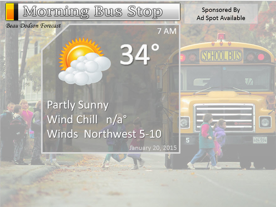
Morning School Bus Stop Weather – Partly sunny with temps in the lower to middle 30’s. NW winds at 5 mph.
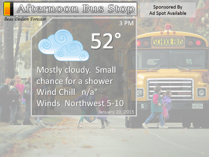
Afternoon School Bus Stop Weather – Mostly cloudy. A small chance for a light shower. Temps will be in the 50’s.
Tuesday night – Mostly cloudy early then partly cloudy late. A small chance for an evening shower. Temperatures will fall into the lower 30’s by sunrise Wednesday morning. Northwest winds at 5-10 mph.
Wednesday – A few cloudy. It won’t be quite as mild as recent days. Windy at times. Highs will be in the upper 40’s. West/northwest winds at 5-10 mph increasing to 15-20 mph during the late morning and afternoon hours. Winds over southern Illinois may gust above 25 mph at times.
Wednesday night – Mostly clear. Cool. A bit chillier than recent nights. Lows will be in the upper 20’s to lower 30’s. North/northwest winds at 5-10 mph.
Thursday – Some high clouds. Cooler than recent days. Highs will only be in the 40’s. North winds at 5-10 mph.

Current Temperatures Around The Local Area


An explanation of what is happening in the atmosphere over the coming days…
Weather Highlights
- Increasing clouds today
- Small chances for a shower late today
- Cooler temperatures over the coming week
- Colder air by the weekend into next week
- Monitoring a system for Sunday/Monday
I hope everyone has enjoyed the January thaw? We will experience temperatures in the 50’s once again today. This is quite amazing without thunderstorms. Normally when you experience temperatures in the 50’s and 60’s, during the Month of January, you can expect some thunderstorms. That is not the case with this current weather pattern.
The weatherman is trying to not to become too bored. This has got to be one of the quieter January’s that I can remember. The lack of winter storms is astonishing.
A weak weather system will approach our region this afternoon. This system will move in from the west. This will be accompanied by increasing clouds and a few light showers. Not everyone will experience rain.
Temperatures today will remain above normal.
Clouds will be on the decrease tonight as our disturbance pushes off to the east. Temperatures will remain above normal tonight, as well.
Calm weather will prevail on Wednesday and Thursday.
No significant winter storms on the weather map.
I do have some colder weather in the long range part of the forecast – see details below in the extended outlook. Remember, as I always say – cold does not always equal snow.
Did you know that the Weather Observatory is funded by people like you? I rely on ad’s on this blog and individual donations. PayPal also allows you to set up a monthly recurring donation. I have had several people give $5, $10, and $20 a month. A recurring donation helps keep the weather information flowing. If you enjoy this blog, the Twitter account, the Facebook interaction, the weather radars, and all of the other information then consider making a donation or setting up a recurring donation (if you don’t use PayPal then contact me through email about how you can mail a donation) beaudodson@usawx.com
Thank you for your support!

No changes in the forecast.

No concerns.
Check out our newest sponsors $5 meal! The DQ Grill and Chill (located across from Noble Park in Paducah, Kentucky) is the newest WeatherTalk Blog sponsor! A local business helping to sponsor the weather information that you have come to love so much.
They have a Facebook Page and I encourage you to check it out. DQ Grill and Chill on Facebook


The wild card tells you where the uncertainties are in the forecast
Wild card in this forecast – I suppose the wild card today will center around whether or not your house experiences a shower. A small chance later this afternoon.

Can we expect severe thunderstorms over the next 24 to 48 hours? Remember that a severe thunderstorm is defined as a thunderstorm that produces 58 mph winds or higher, quarter size hail or larger, and/or a tornado.
Thunderstorm threat level is ZERO


Will I need to take action?
No action required. Calm weather.

How much precipitation should we expect over the next few days?
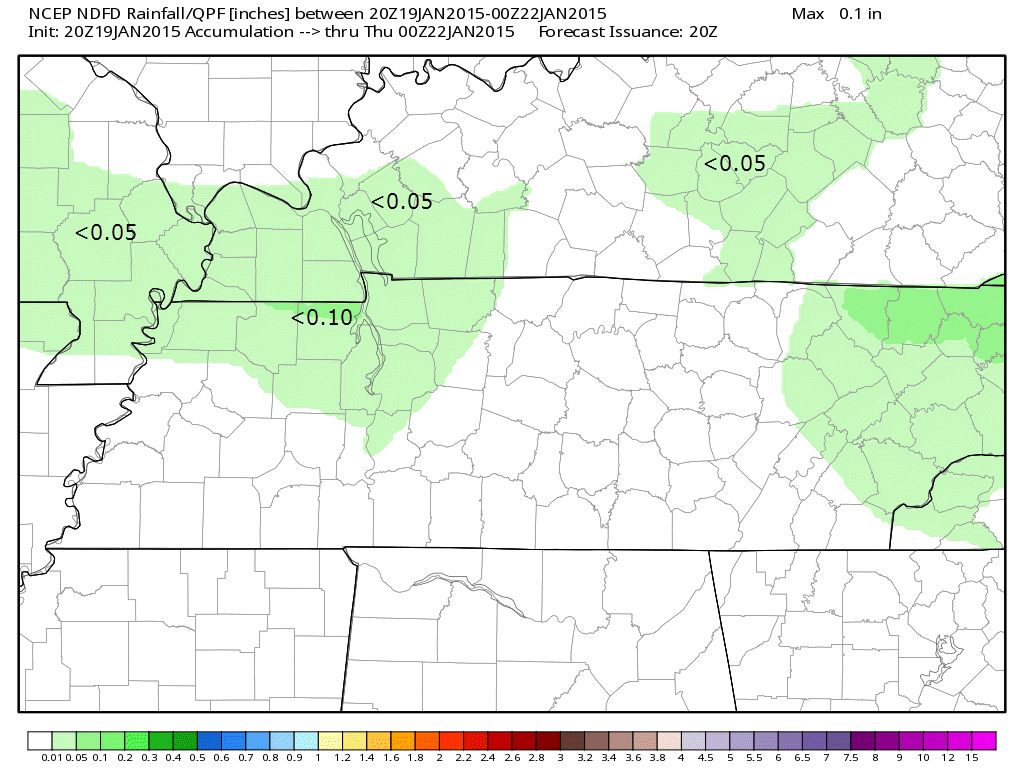
If it rains on Tuesday it will be light rain. Less than 0.05″. This is the official National Weather Service rainfall forecast. They have painted in tiny amounts of our area for Tuesday.
We have a new sponsor! G&C Multi-Services out of Paducah, Kentucky. G & C Multi-Services is a service provider in Western Kentucky that provides industrial and commercial equipment fabrication, machine troubleshooting, repair and maintenance, and installation. They can custom fabricate steel, stainless, and aluminum products per customer specifications.
Visit their web-site here. Or click the ad below! They have a Facebook page and it can be viewed here.


Do I even have to say it? No snow in the forecast today, tomorrow, or Thursday. I am watching a system for Sunday. See the extended part of the forecast for details.
Keep checking back!

This section of the blog is speculative forecast information. Because it is past the range of what meteorologists can forecast accurately, it should be considered speculation. Anything past day 5 is considered a long range forecast.
Winter isn’t over. Even though we had a nice January thaw…I am already tracking the next shot of cold air (shots of cold air).
But, let’s be honest. This winter has not produced a single significant winter storm system. Much of the nation has been experiencing non-eventful weather. Meteorological spring begins on March 1st. So, let’s not get overly excited because it might turn cold again.
I continue to lean towards the next big arctic outbreak being centered more towards our east and northeast vs being centered over our region (like the one a week or two ago). This will likely mean colder temperatures as we push into the weekend and next week. First few days of February, as well.
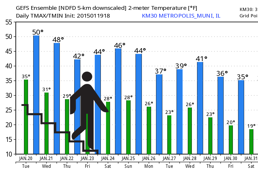
The EC model does show our region being a lot colder than the GFS. This will need to be monitored. Still plenty of time for forecast changes. The bottom line is that our January thaw is coming to an end.
We will slowly step down in temperatures.
Here are the GFS model numbers for temperatures over the coming 6-10 days. You can see we progressively become colder. Blue would be high temperatures. Green would be low temperatures. The date is at the bottom of the graphic.
Here are the high and low temperatures.

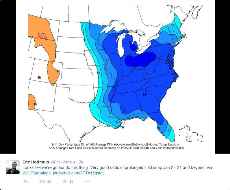
Of note – the CIPS Analogs are showing the last week of January turning cold again. But, it is more centered on the northeast U.S. vs right over our region. Yet another signal for at least colder weather the last week of January. CIPS looks at the forecasted weather set-up and compares it to historic analogs. Then it comes up with some forecast thoughts.
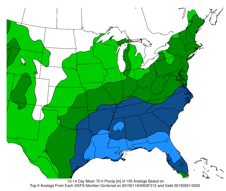
Let’s look at another interesting CIPS Map – this one is centered around the very end of January and first part of February. It does show that there is the potential for a precipitation event. A southern track storm?
You can see the data is weighted towards the heavier totals being to our south. This does lead me to believe a southern track winter storm might be possible, but the problem is that it is in the very furthest of the long range data. Thus, there can be no confidence whatsoever in making a forecast. Too far out. Something we can watch as we move forward.
Any other precipitation makers to monitor?
I am tracking one storm system for next Sunday/Monday. This is a clipper coming down from Canada. Typically these clippers tend to move a bit further south and southwest than the models show.
Right now the GFS is the furthest southwest – it is an outlier. Most of the models track the area of low pressure through Illinois/Indiana/Ohio. This would put our region in the rain zone (for the most part).
Now, if the system does move further south and west then that opens the door for snow in our region. Remember, if you want snow then you want the low to track south of your location. The cold air is located on the north side of the low.
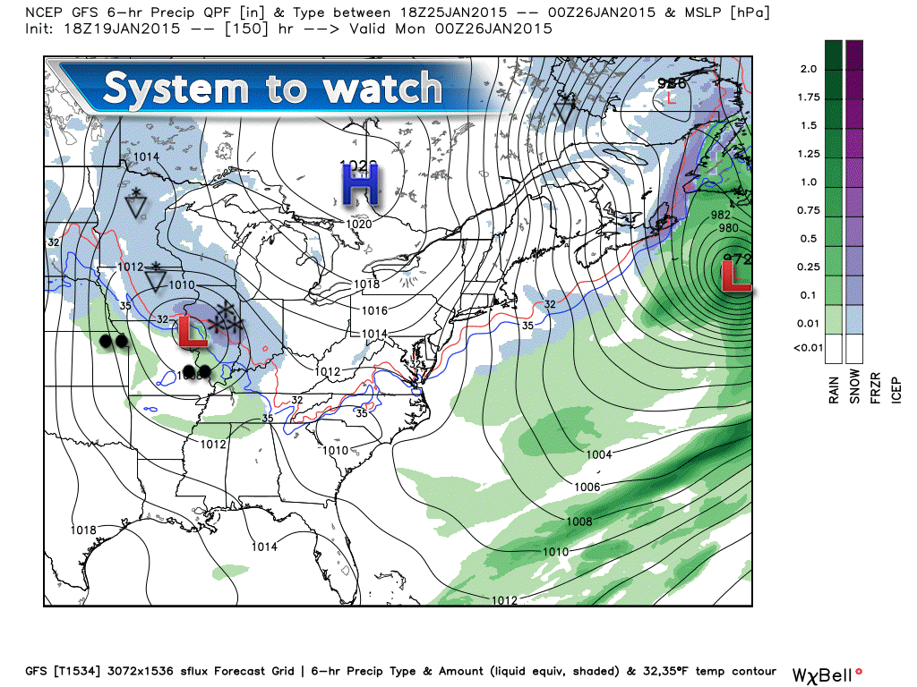
Here is what the GFS shows for late Sunday into Monday. This low is likely to track a bit further east than the GFS is showing – but, you get the general idea. Some precipitation may be on tap for later this weekend into early next week.
I will closely monitor the weekend system.
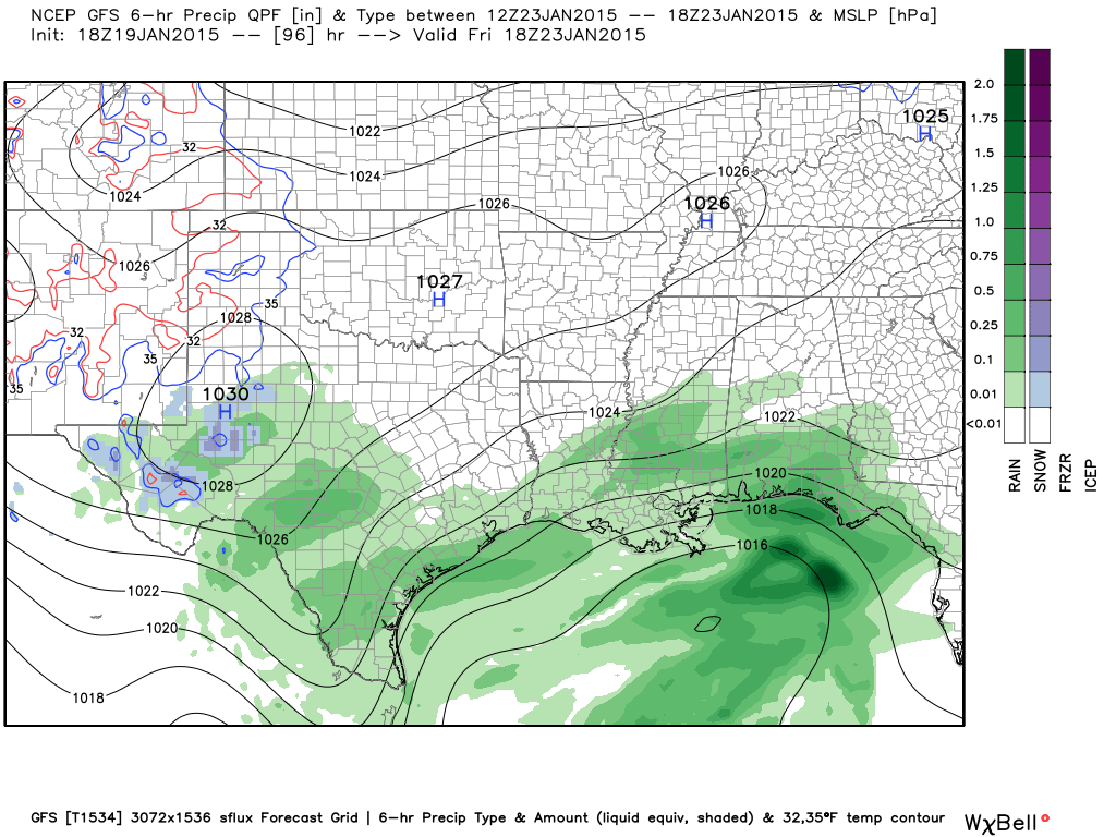
Remember that system I have been tracking for the past 10 days – the southern storm? It is going to go way south of our region. That has been the forecast for awhile now. No significant trends northward on the new data. This is a southern storm. Had that one tracked further north then we would have had a decent snowstorm in our region. But, it just wasn’t in the cards this time around. Image from www.weatherbell.com
This is the Friday forecast weather map. You can see all of the rain well to our south.

Who do you trust for your weather information and who holds them accountable?
I have studied weather in our region since the late 1970’s. I have 37 years of experience in observing our regions weather patterns. My degree is in Broadcast Meteorology from Mississippi State University and an Associate of Science (AS). I am currently working on my Bachelor’s Degree in Geoscience. Just need to finish two Spanish classes!
I am a member of the American Meteorological Society. I am a NOAA Weather-Ready Nation Ambassador. And, I am the Meteorologist for McCracken County Emergency Management.
I own and operate the Southern Illinois Weather Observatory.
There is a lot of noise on the internet. A lot of weather maps are posted without explanation. Over time you should learn who to trust for your weather information.
My forecast philosophy is simple and straight forward.
- Communicate in simple terms
- To be as accurate as possible within a reasonable time frame before an event
- Interact with you on Twitter, Facebook, and the blog
- Minimize the “hype” that you might see on television or through other weather sources
- Push you towards utilizing wall-to-wall LOCAL TV coverage during severe weather events
I am a recipient of the Mark Trail Award, WPSD Six Who Make A Difference Award, Kentucky Colonel, and the Caesar J. Fiamma” Award from the American Red Cross. In 2009 I was presented with the Kentucky Office of Highway Safety Award. I was recognized by the Kentucky House of Representatives for my service to the State of Kentucky leading up to several winter storms and severe weather outbreaks.
If you click on the image below you can read the Kentucky House of Representatives Resolution.

I am also President of the Shadow Angel Foundation which serves portions of western Kentucky and southern Illinois.

We have regional radars and local city radars – if a radar does not seem to be updating then try another one. Occasional browsers need their cache cleared. You may also try restarting your browser. That usually fixes the problem. Occasionally we do have a radar go down. That is why I have duplicates. Thus, if one fails then try another one.
If you have any problems then please send me an email beaudodson@usawx.com
WEATHER RADAR PAGE – Click here —
We also have a new national interactive radar – you can view that radar by clicking here.
Local interactive city radars include St Louis, Mt Vernon, Evansville, Poplar Bluff, Cape Girardeau, Marion, Paducah, Hopkinsville, Memphis, Nashville, Dyersburg, and all of eastern Kentucky – these are interactive radars. Local city radars – click here
NOTE: Occasionally you will see ground clutter on the radar (these are false echoes). Normally they show up close to the radar sites – including Paducah.

Regional Radar – Click on radar to take you our full radar page.


Regional Radar

Please visit your local National Weather Service Office by clicking here. The National Weather Service Office, for our region, is located in Paducah, Kentucky. They have a lot of maps and information on their site. Local people…local forecasters who care about our region.


Here is the official 6-10 day and 8-14 day temperature and precipitation outlook. Check the date stamp at the top of each image (so you understand the time frame).
The forecast maps below are issued by the Weather Prediction Center (NOAA).


The latest 8-14 day temperature and precipitation outlook. Note the dates are at the top of the image. These maps DO NOT tell you how high or low temperatures or precipitation will be. They simply give you the probability as to whether temperatures or precipitation will be above or below normal.


Many of my graphics are from www.weatherbell.com – a great resource for weather data, model data, and more


This blog was inspired by ABC 33/40’s Alabama Weather Blog – view their blog
Current tower cam view from the Weather Observatory- Click here for all cameras.

Southern Illinois Weather Observatory

The Weather Observatory

Southern Illinois Weather Observatory
WSIL TV 3 has a number of tower cameras. Click here for their tower camera page & Illinois Road Conditions

Marion, Illinois
WPSD TV 6 has a number of tower cameras. Click here for their tower camera page & Kentucky Road Conditions & Kentucky Highway and Interstate Cameras

Downtown Paducah, Kentucky
Benton, Kentucky Tower Camera – Click here for full view

Benton, Kentucky

I24 Paducah, Kentucky

I24 Mile Point 9 – Paducah, KY

I24 – Mile Point 3 Paducah, Kentucky

You can sign up for my AWARE email by clicking here I typically send out AWARE emails before severe weather, winter storms, or other active weather situations. I do not email watches or warnings. The emails are a basic “heads up” concerning incoming weather conditions.