We have some great sponsors for the Weather Talk Blog. Please let our sponsors know that you appreciate their support for the Weather Talk Blog.
Milner and Orr Funeral Home and Cremation Services located in Paducah, Kentucky and three other western Kentucky towns – at Milner and Orr they believe in families helping families. You can find Milner and Orr on Facebook, as well.
![]()
.

For all of your families eye care needs. Visit their web-site here. Or, you can also visit their Facebook page.
.

Endrizzi’s Storm Shelters – For more information click here. Endrizzi Contracting and Landscaping can be found on Facebook, as well – click here
.

Best at Enabling Body Shop Profitability since 1996. Located In Paducah Kentucky and Evansville Indiana; serving all customers in between. They provide Customer Service, along with all the tools necessary for body shops to remain educated and competitive. Click the logo above for their main web-site. You can find McClintock Preferred Finishes on Facebook, as well
.

Duck/goose decoys? Game calls? Optics? We have you covered! Click the logo above or visit Final Flight on Facebook, as well.
.
.
I have launched the new weather texting service! I could use your help. Be sure and sign up and fully support all of the weather data you see each day.
This is a monthly subscription service. Supporting this helps support everything else. The cost is $3 a month for one phone, $5 a month for three phones, and $10 a month for seven phones.
For more information visit BeauDodsonWeather.com
Or directly sign up at Weathertalk.com


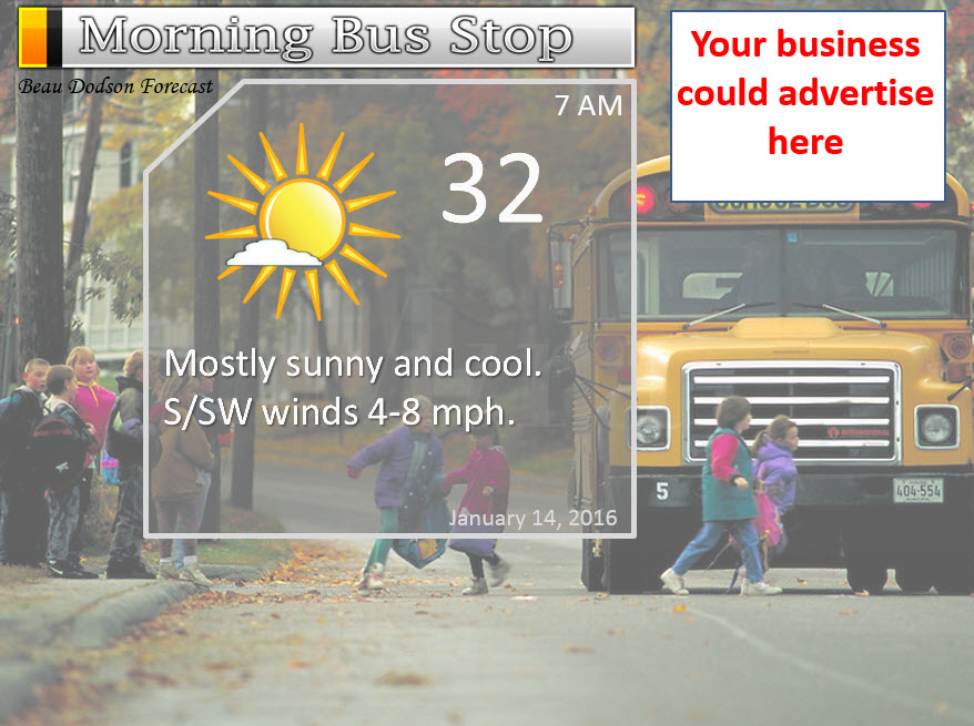
This forecast update covers far southern Illinois, far southeast Missouri, and far western Kentucky. See the coverage map on the right side of the blog.
Remember that weather evolves. Check back frequently for updates, especially during active weather.

Wednesday night – Mostly clear. Just a few passing clouds. Cold, but not as cold as recent nights.
Temperatures: Lows from 32 to 36 degrees.
Winds: Southwest winds at 4-8 mph
What is the chance for precipitation? 0%
Coverage of precipitation? None
My confidence in this part of the forecast verifying is High
Should I be concerned about snow or ice? No
Should I cancel my outdoor plans? No
Is severe weather expected? No
What impact is expected? None.
Thursday – A mix of sun and clouds. Not as cold.
Temperatures: Highs will range from 46-52 degrees. Can’t rule out a bit higher. Hopefully. 🙂
Winds: Southwest winds at 6-12 mph. Winds may be gustier during the afternoon hours with gusts up to 20 mph.
What is the chance for precipitation? 0%
Coverage of precipitation? None
My confidence in this part of the forecast verifying is High
Should I be concerned about snow or ice? No
Should I cancel my outdoor plans? No
Is severe weather expected? No
What impact is expected? None
Thursday night – Increasing clouds with a chance for a few showers after midnight. Gusty winds.
Temperatures: Lows from 42 to 46 degrees.
Winds: Southwest winds at 8-16 mph. Gusty at times.
What is the chance for precipitation? 20% before midnight and 40% after midnight
Coverage of precipitation? Scattered to widespread after midnight.
My confidence in this part of the forecast verifying is High
Should I be concerned about snow or ice? No
Should I cancel my outdoor plans? No
Is severe weather expected? No
What impact is expected? Wet roadways
Friday – Cloudy. A chance for a few morning showers. Rain showers diminishing during the late morning and early afternoon hours. Rainfall totals from this system should range from 0.10″-0.30″. There is some indication that parts of the region won’t pick up much from this fast moving system. Keep that in mind.
Temperatures: Highs will range from 46-52 degrees. Temperatures may fall during the afternoon hours behind the cold front.
Winds: Southwest winds at 8-16 mph and gusty. Winds will switch around to the west/northwest behind the cold front at 10-20 mph.
What is the chance for precipitation? 40%-50% before noon. 20% after 12 pm.
Coverage of precipitation? Scattered to widespread early in the day.
My confidence in this part of the forecast verifying is High
Should I be concerned about snow or ice? No
Should I cancel my outdoor plans? No
Is severe weather expected? No
What impact is expected? Wet roadways.
Friday night – Some clouds. Colder.
Temperatures: Lows from 28 to 34 degrees.
Winds: Northwest winds at 5-10 mph with gusts above 15 mph.
What is the chance for precipitation? 10% chance
Coverage of precipitation? None to isolated.
My confidence in this part of the forecast verifying is High
Should I be concerned about snow or ice? No
Should I cancel my outdoor plans? No
Is severe weather expected? No
What impact is expected? None
Saturday – Some clouds and colder.
Temperatures: Highs will range from 36 to 42 degrees.
Winds: Northwest winds at 8-16 mph and gusty.
What is the chance for precipitation? 10%
Coverage of precipitation? None
My confidence in this part of the forecast verifying is High
Should I be concerned about snow or ice? No
Should I cancel my outdoor plans? No
Is severe weather expected? No
What impact is expected? None
I am watching a disturbance on Saturday night and Sunday morning. These type of systems can occasionally produce light snow.
Bitterly cold air likely Sunday night and Monday morning. Lasting into Tuesday. Some data indicates single digits will be possible. Let’s keep an eye on the cold weather.
The School Bus Stop forecast needs a sponsor!


Don’t forget to check out the Southern Illinois Weather Observatory web-site for weather maps, tower cams, scanner feeds, radars, and much more! Click here

An explanation of what is happening in the atmosphere over the coming days…
Highlights
1. Rain chances ramp up Thursday night and Friday, but some may miss out
2. Colder for the weekend
3. Weak disturbance could deliver some light snow or precipitation Saturday night/Sunday.
The main weather story for the next 24-48 hours will be an area of low pressure that will move out of the Central United States and track into Missouri and Illinois. Since the low will be passing to our north, we will be on the south and west side of the system. That is the warm side. That means rain.
Rain chances ramp up after midnight on Thursday night. Rain chances continue into Friday. Rain should come to an end on Friday night. Rainfall totals have trended downward with this event. Perhaps 0.10″-0.30″. Some places will not pick up any rainfall.
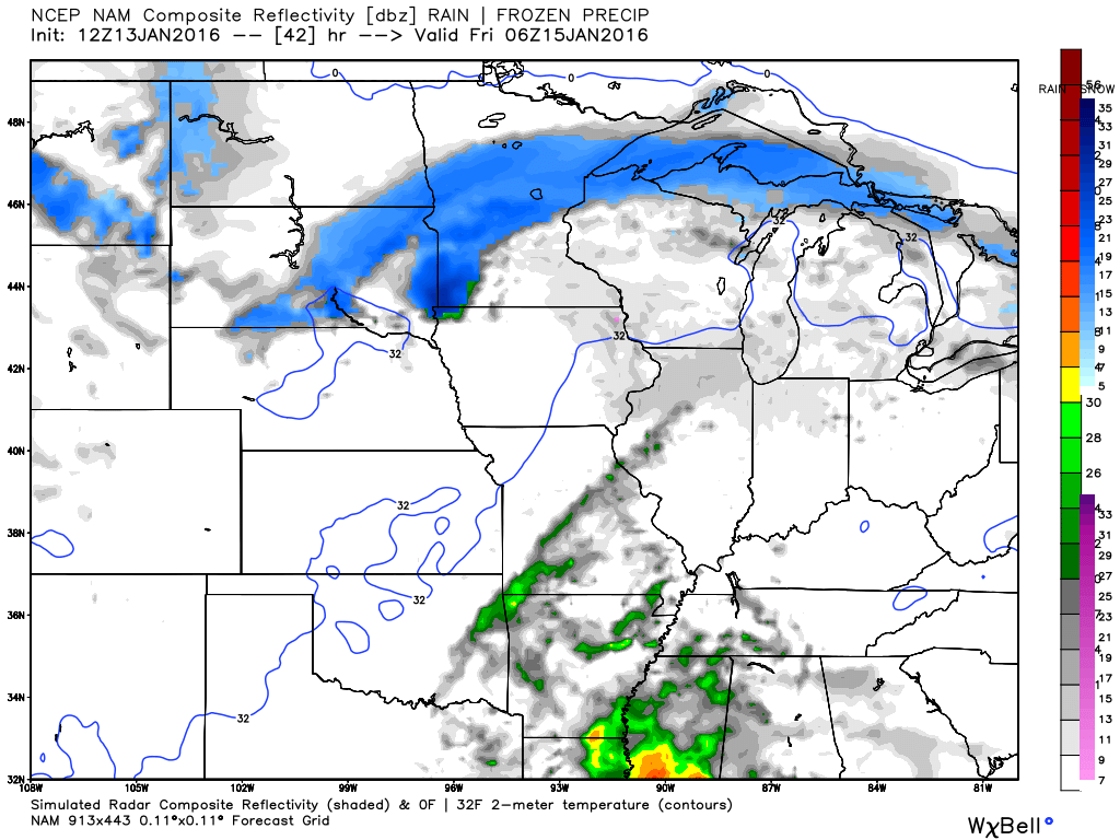
Here are some future-cast radar images. This is what radar might look like with this system. If the NAM is correct then some places might not pick up much rain at all.
This first image is for early Friday morning (around midnight). Green represents rain. Blue is snow.
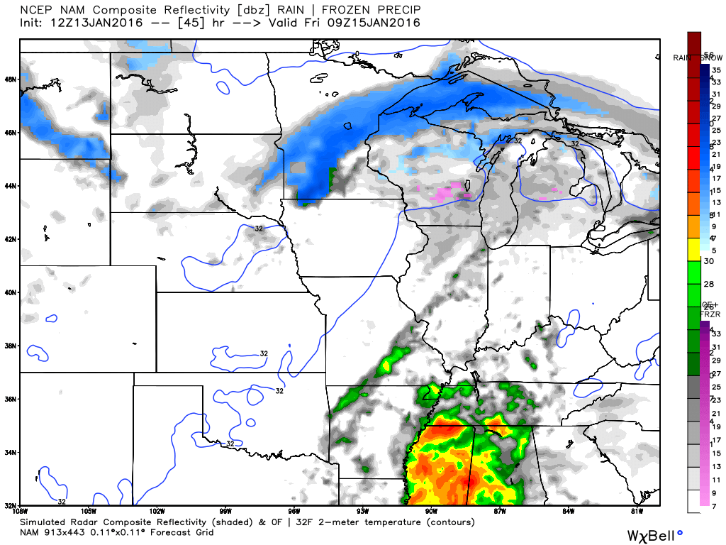
This next image is for Friday at 3 am. Heaviest rain is to our south.
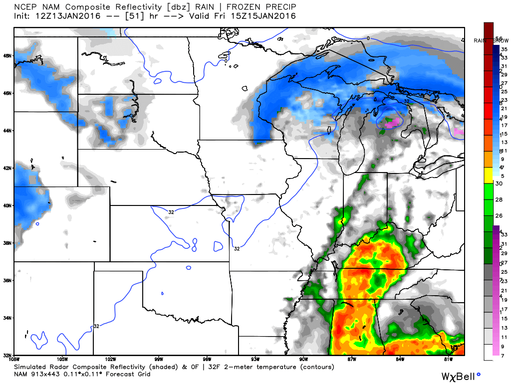
This next image is for Friday morning around 9 am. NAM sure does not show much in the way of rain.
We will warm up a bit ahead of the area of low pressure. We will then cool back down behind the front.
Let’s look at some weather maps from weatherbell.com
This first graphic shows you temperatures for Friday afternoon. See the tongue of warmer temperatures that pushes into our area? This is ahead of the cold front. Colder air behind the front. You can see the area of low pressure. Remember, the low rotates counter-clockwise. Thus, it pulls warm air northward ahead of it. And, it pulls in colder air behind it. Look at North Dakota. Zero degree weather. Expect some 50s in our area ahead of the cold front on Friday. Won’t last long.
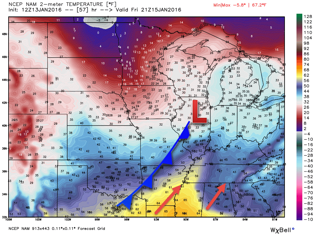
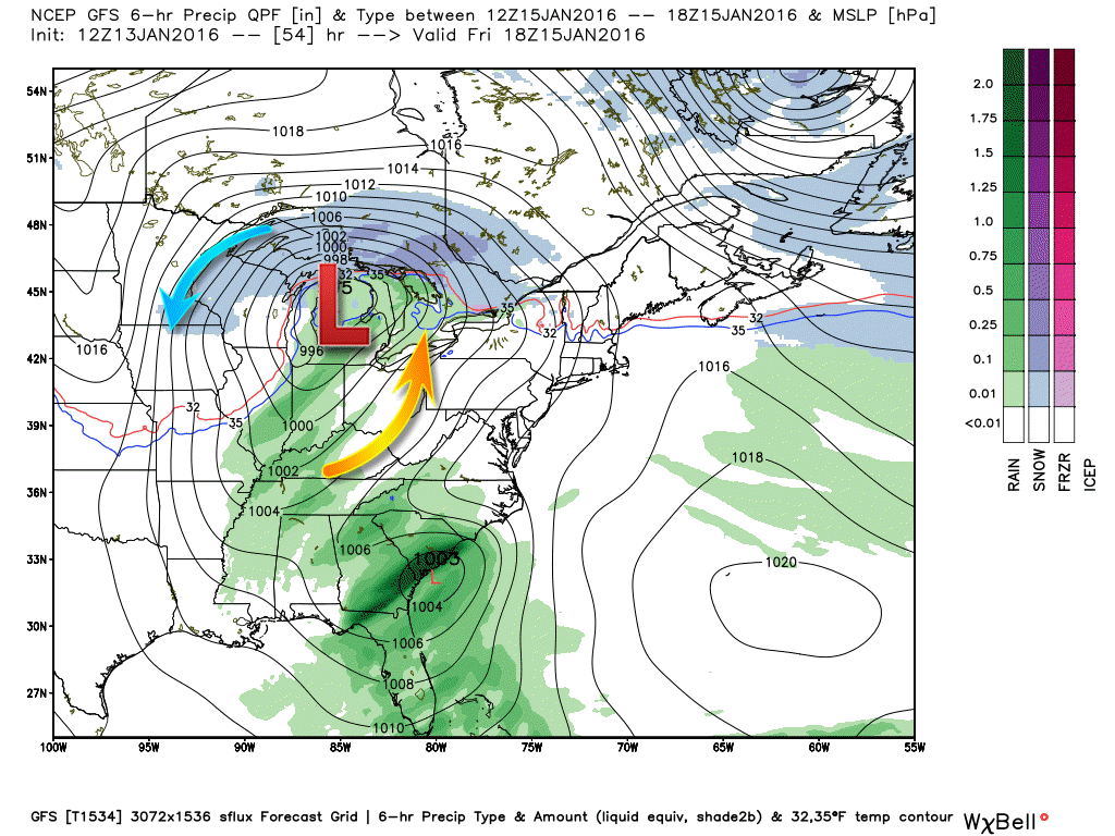
Here is the surface weather map. This is for Friday morning. You can see the low well to our north (the red L). Green represents some rain and rain showers. Can’t rule out thunder. This is a quick moving system. Rainfall totals won’t be all that great.
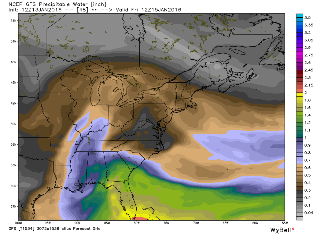
Here is the PWAT map. PWAT is a measure of moisture in the atmosphere. Not a lot of moisture ahead of this system, but enough for some rain and maybe a thunderstorm as the cold front advances eastward. You can see those colors pulling northward into our area.
The blue colors represent PWAT values of 0.70-0.80. Again, as the low passes our region the moisture is puller northward from the Gulf of Mexico.
You can read more about PWAT values here
We will have to deal with some clouds on Saturday and Sunday. Perhaps some clearing on Sunday afternoon. I am watching a clipper system that could produce light snow on Saturday night and Sunday morning.
Here is the future-cast satellite view for Saturday morning. White represents cloud.

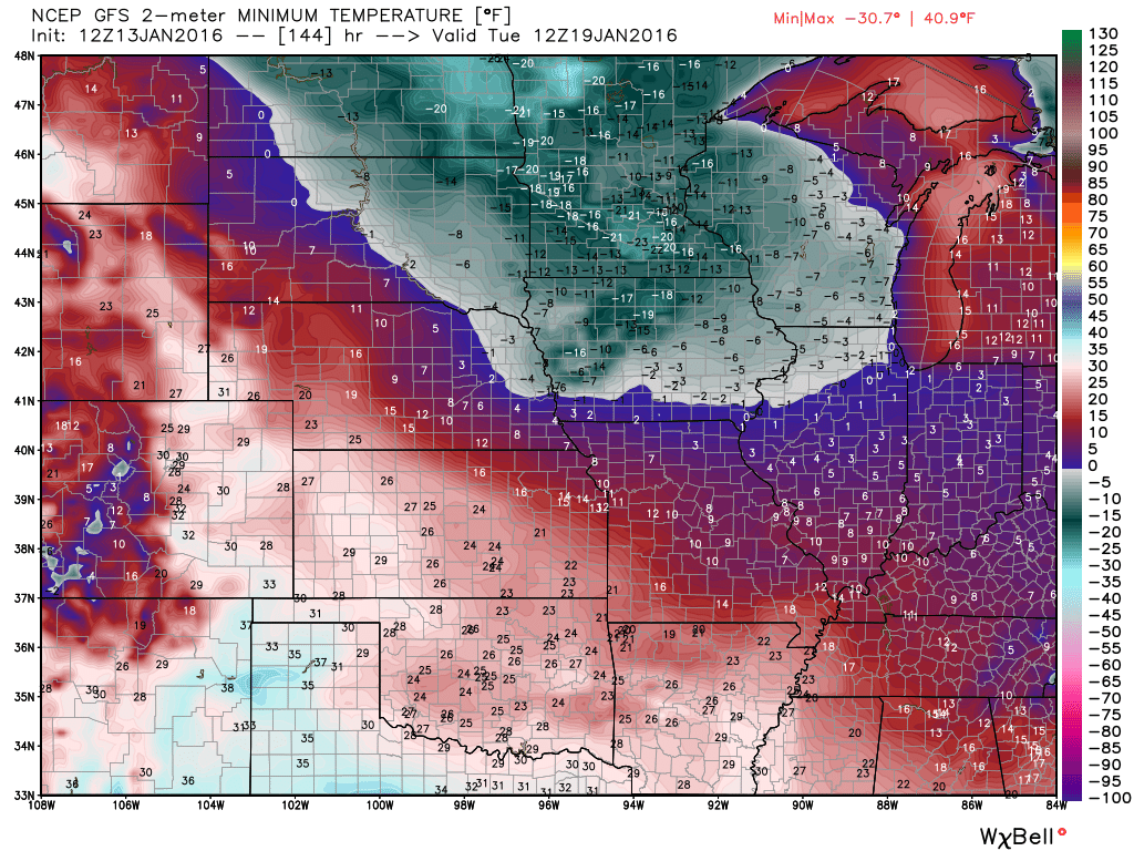
The GFS guidance is indicating some very cold air by Sunday night into the middle of next week. It is showing single digits for the area. Let’s keep an eye on the cold shot coming down the pike.
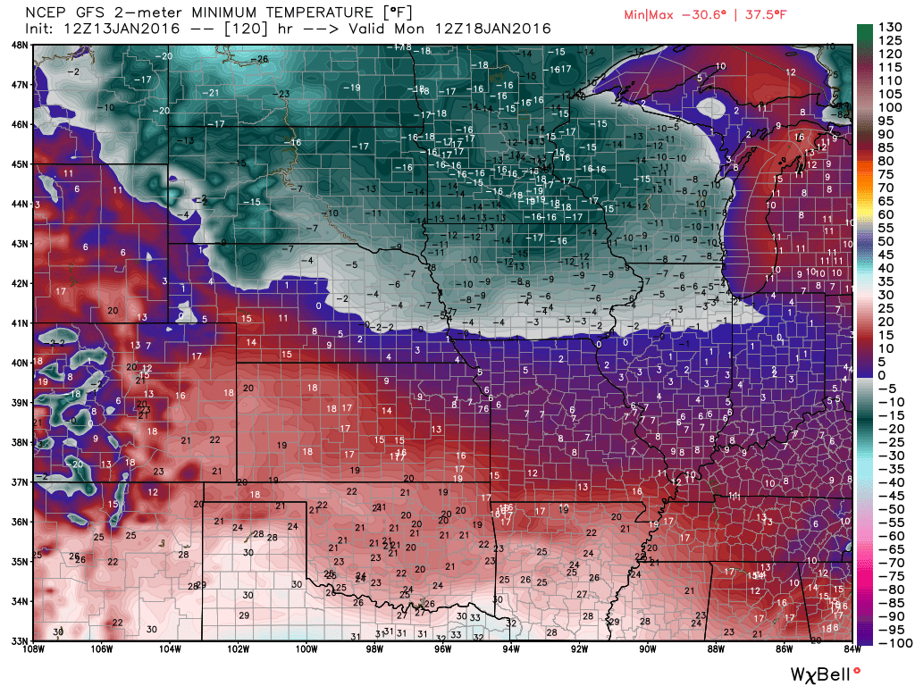
Here are the low temperature number, from the GFS guidance, for Monday and Tuesday morning. Click images for a larger view.
This first image is for Monday morning. Look at Minnesota. -15 degrees! Brrr
GFS shows 5 above to 12 above in our region. There is some disagreement in the model guidance as to just how cold it will become.
This map is for Tuesday morning.
I do see a lot of cold air in the charts. Whether we can pull a storm into this cold air is the question.

Here are the current river stage forecasts. You can click your state and then the dot for your location. It will bring up the full forecast and hydrograph.
Click Here For River Stage Forecasts…

Monitoring Saturday night/Sunday morning.

Thursday – No snow or ice
Friday – No snow or ice anticipated
Saturday – No snow or ice anticipated.
Saturday night – Monitoring for light snow. Low confidence.
Sunday – Monitoring for light snow. Low confidence.

Mentioned snow over the weekend. Low confidence on a light event moving in from the northwest.

No major concerns through Friday night. I am watching for a possible light snow event on Saturday night/Sunday. Low confidence.

No major concerns. Rivers do remain high, use care if you have to be out on the rivers.

The wild card in this forecast will be the possibility of a clipper system on Saturday night and Sunday. Clippers are fast moving systems that move down from Canada into the Central United States. Or, a disturbance moving down from Canada. Either way, they can produce some light snow. Depending on temperatures the snow could be fluffy. Not a sure bet, thus it is the wild card.

How much precipitation should we expect over the next few days?
Rain chances for Thursday night and Friday appear likely. Rainfall totals should be fairly light. 0.10″-0.30″. Some areas may miss out on the rainfall. Thus, no rain for some.
Light clipper system on Saturday night and Sunday could produce a little light snow. I will be monitoring it.


Can we expect severe thunderstorms over the next 24 to 48 hours? Remember that a severe thunderstorm is defined as a thunderstorm that produces 58 mph winds or higher, quarter size hail or larger, and/or a tornado.
The thunderstorm threat level will be a ZERO on Thursday. Small chance for thunder on Friday.

Here are the current river stage forecasts. You can click your state and then the dot for your location. It will bring up the full forecast and hydrograph.
Click Here For River Stage Forecasts…
Here are some current forecast hydrographs. These will be updated each day with new information.


Smithland Lock and Dam

Paducah, Kentucky Forecast Stage

Cairo, Illinois

Cape Girardeau, Missouri

We have regional radars and local city radars – if a radar does not seem to be updating then try another one. Occasional browsers need their cache cleared. You may also try restarting your browser. That usually fixes the problem. Occasionally we do have a radar go down. That is why I have duplicates. Thus, if one fails then try another one.
If you have any problems then please send me an email beaudodson@usawx.com
WEATHER RADAR PAGE – Click here —
We also have a new national interactive radar – you can view that radar by clicking here.
Local interactive city radars include St Louis, Mt Vernon, Evansville, Poplar Bluff, Cape Girardeau, Marion, Paducah, Hopkinsville, Memphis, Nashville, Dyersburg, and all of eastern Kentucky – these are interactive radars. Local city radars – click here
NOTE: Occasionally you will see ground clutter on the radar (these are false echoes). Normally they show up close to the radar sites – including Paducah.


Here is the official 6-10 day and 8-14 day temperature and precipitation outlook. Check the date stamp at the top of each image (so you understand the time frame).
The forecast maps below are issued by the Weather Prediction Center (NOAA).


The latest 8-14 day temperature and precipitation outlook. Note the dates are at the top of the image. These maps DO NOT tell you how high or low temperatures or precipitation will be. They simply give you the probability as to whether temperatures or precipitation will be above or below normal.


Here are the current river stage forecasts. You can click your state and then the dot for your location. It will bring up the full forecast and hydrograph.
Click Here For River Stage Forecasts…

Who do you trust for your weather information and who holds them accountable?
I have studied weather in our region since the late 1970’s. I have 37 years of experience in observing our regions weather patterns. My degree is in Broadcast Meteorology from Mississippi State University and an Associate of Science (AS). I am currently working on my Bachelor’s Degree in Geoscience.
My resume includes:
Member of the American Meteorological Society.
NOAA Weather-Ready Nation Ambassador.
Meteorologist for McCracken County Emergency Management. I served from 2005 through 2015.
I own and operate the Southern Illinois Weather Observatory.
Recipient of the Mark Trail Award, WPSD Six Who Make A Difference Award, Kentucky Colonel, and the Caesar J. Fiamma” Award from the American Red Cross.
In 2009 I was presented with the Kentucky Office of Highway Safety Award.
Recognized by the Kentucky House of Representatives for my service to the State of Kentucky leading up to several winter storms and severe weather outbreaks.
I am also President of the Shadow Angel Foundation which serves portions of western Kentucky and southern Illinois.
There is a lot of noise on the internet. A lot of weather maps are posted without explanation. Over time you should learn who to trust for your weather information.
My forecast philosophy is simple and straight forward.
- Communicate in simple terms
- To be as accurate as possible within a reasonable time frame before an event
- Interact with you on Twitter, Facebook, and the blog
- Minimize the “hype” that you might see on television or through other weather sources
- Push you towards utilizing wall-to-wall LOCAL TV coverage during severe weather events
I am a recipient of the Mark Trail Award, WPSD Six Who Make A Difference Award, Kentucky Colonel, and the Caesar J. Fiamma” Award from the American Red Cross. In 2009 I was presented with the Kentucky Office of Highway Safety Award. I was recognized by the Kentucky House of Representatives for my service to the State of Kentucky leading up to several winter storms and severe weather outbreaks.
If you click on the image below you can read the Kentucky House of Representatives Resolution.

Many of my graphics are from www.weatherbell.com – a great resource for weather data, model data, and more


You can sign up for my AWARE email by clicking here I typically send out AWARE emails before severe weather, winter storms, or other active weather situations. I do not email watches or warnings. The emails are a basic “heads up” concerning incoming weather conditions.