
We have our first sponsor for the blog. Milner and Orr Funeral Home and Cremation Services located in Paducah, Kentucky and three other western Kentucky towns – at Milner and Orr they believe in families helping families.
![]()

This forecast update covers far southern Illinois, far southeast Missouri, and far western Kentucky. See the coverage map on the right side of the blog.
Monday – Some morning rain. As temperatures fall there could be a few patches of light freezing drizzle. Also, remember that if water remains on roadways, as temperatures fall, that there could be some patchy slick spots. Cloudy. Temperatures holding steady or even falling in the afternoon. North winds at 10-15 mph. This will make it feel colder outside.
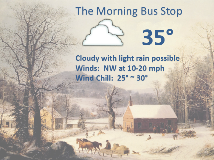
Morning School Bus Stop Weather – Scattered rain. Cold. Raw. Temperatures only in the 30’s with north winds at 10 mph.
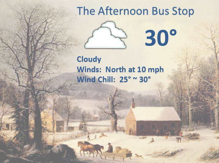
Afternoon School Bus Stop Weather – Cloudy, cold, raw. Patchy drizzle possible. Temperatures in the 30’s. North winds at 10 mph.
Monday night – Some clouds. Seasonably chilly. Low temperatures in the 22 to 26 degree range. North winds at 10-15 mph.
Tuesday – Partly sunny and chilly. High temperatures in the upper 20’s and lower 30’s. North winds at 10 mph.
Tuesday night – Just a few clouds. Cold. Low temperatures from 16 to 22 degrees. North winds at 5-10 mph.
Wednesday – Mostly cloudy and seasonably cold. High temperatures in the middle to upper 20’s.

Current Temperatures Around The Local Area


An explanation of what is happening in the atmosphere over the coming days.
Well, I for one am glad that our weekend system is winding down. It was certainly a pain to forecast what would happen over portions of the region. It wasn’t so bad forecasting for western Kentucky where temperatures were above freezing. It was tricky for southeast Missouri and southern Illinois. A lot of accidents were reported in areas that experienced freezing rain.
Probably my worst forecast in quite some time (for parts of southeast Missouri and parts of southern Illinois). I never dreamed the freezing line would push so far north. Hopefully the next system will be a bit easier to forecast. I knew all along this one would be a pain…and so it was.
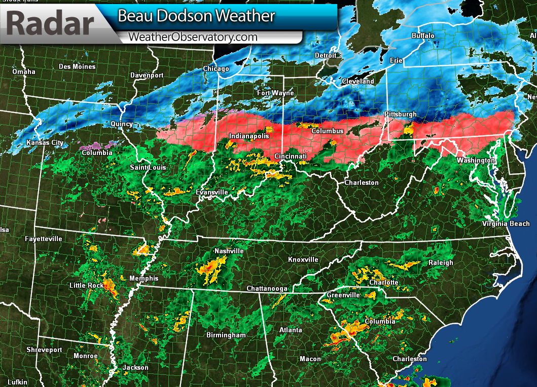
At 10 pm last night the system extended from Canada to the Gulf Of Mexico. Snow in blue – ice in pink – rain in green.
That is a significant ice storm in aerial coverage. Thousands of accidents because of this event. All of that pink is ice. Click for larger view.
But, this weather system is winding down and moving out. So, wave goodbye.
It will be turning colder today as the system pulls away. We won’t see temperatures rise much at all today. As a matter of fact, temperatures will actually start falling this afternoon on northerly winds. There will be some light precipitation left over and that should come to an end later today or this afternoon. As temperatures fall into the 20’s there could be some moisture left on roadways or even a little bit of drizzle here or there. If that were to happen then a few slick spots are possible. Remember that bridges will freeze before other surfaces.
Tonight will be chilly, but not as extreme as what happened last week.
I was watching a potential snow system for Wednesday into Thursday. Right now it appears this system is going to be too weak and too far south to cause too many problems locally. I will continue to monitor and if the system drifts a bit further north or is a bit more intense than anticipated then we can reevaluate that part of the forecast.
We are going to see low temperatures dip back into the teens on a few days this week. We won’t be going back to single digits, so that is good news.
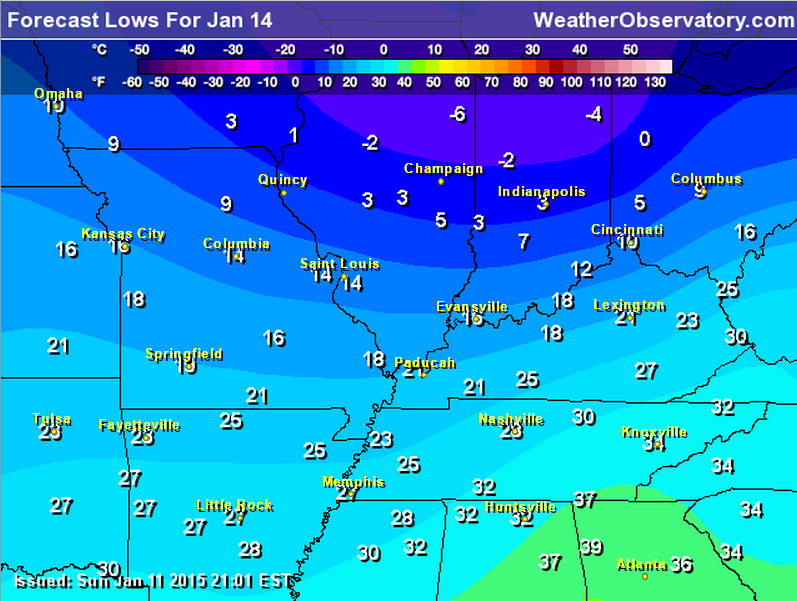
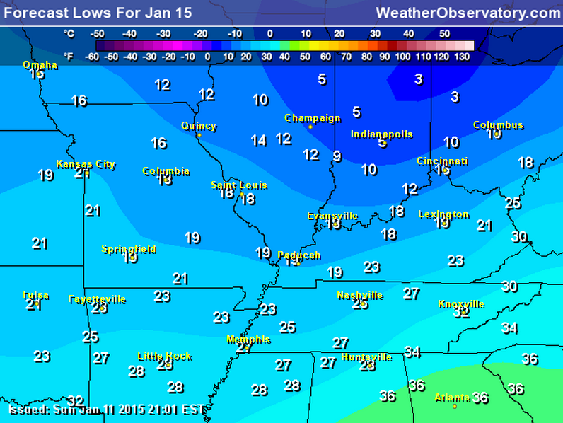
Wednesday and Thursday morning will likely bring some teens.
Here is the Wednesday morning low temperature forecast
Here is the Thursday morning low temperature forecast
Since we are not able to get any snow in our region. How about a beautiful photograph of snow elsewhere? This is from the www.wunderground.com website. Always some nice photographs there.

Now, the good news 🙂 – a January semi-thaw is showing up in the forecast cards for later this week into next week. See the extended discussion for that topic.

No major changes to the ongoing forecast.

Temperatures later today and tonight will fall into the 20’s. If there is any moisture left on roadways then it could freeze. Some patchy drizzle would make this more likely. Just keep that in mind.
Temperatures probably won’t go below freezing until late this afternoon or early evening.

The wild card tells you where the most uncertainty is in the current forecast.
Wild card in this forecast – I don’t have a wild card in today’s forecast.

Can we expect severe thunderstorms over the next 24 to 48 hours? Remember that a severe thunderstorm is defined as a thunderstorm that produces 58 mph winds or higher, quarter size hail or larger, and/or a tornado.
Thunderstorm threat level is ZERO


Will I need to take action?
An umbrella this morning might be in order for some of you.

How much rain should this system produce over our region?
Rain will end today with just small additional amounts (less than 0.05″)
Not expecting any additional precipitation through Friday. I am watching the southern system on Wednesday/Thursday. Thinking is that may remain too far south for much impact in our region. I will monitor for changes, as always.
We have a new sponsor for WeatherTalk! G&C Multi-Services out of Paducah, Kentucky. G & C Multi-Services is a service provider in Western Kentucky that provides industrial and commercial equipment fabrication, machine troubleshooting, repair and maintenance, and installation. They can custom fabricate steel, stainless, and aluminum products per customer specifications.
Visit their web-site here. Or click the ad below! They have a Facebook page and it can be viewed here.


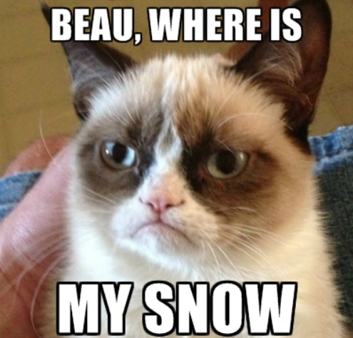
Snow fans, I feel your pain. I really do. We just can’t seem to get a winter storm to bring you some white gold. We had zero degree weather last week and then rain on Sunday. How much more of a jab can mother nature throw your way?
Now, for you anti-snow readers…this must be your winter. Lucky you. You must be sipping your hot coco and smiling.
Maybe February will bring some snow?
A January semi-thaw is about to move into the region. Some of the data shows thunderstorms next week. Check out the extended forecast for details on that long range event.


Well, a January semi-thaw is appearing in the charts. I guess we deserve a January thaw after all the cold air last week. Not that this winter has been severe, or anything like that. We have been a bit spoiled. December was mostly above normal in the temp department. We had a lot of clouds, but it was not that bad.
Now, we are looking at normal to above normal temperatures as we push towards the end of the week into the first part of next week.
We may have to deal with a warm system next week. Now, this is a long way off in the weather world. We call that lala land in forecasting. But, some of the data indicates a deep area of low pressure moving into the Missouri Valley on Monday/Tuesday. That would mean thunderstorms for our region. Since this is so far off we won’t make a forecast as to what happens. We will just watch and track the data as it comes in over the coming days.
Other data holds this system off until the middle or end of next week. Needless to say there is not enough confidence to make a forecast concerning that particular precipitation maker.
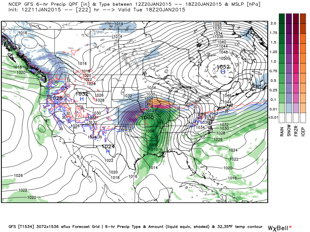
Here is what the GFS model is showing for early next week. Let’s watch this and see how it changes over the coming week. We can compare it to this image as we move forward.
Of course, that far out there may not even be a storm to track. It is a bit more interesting because the ensembles are showing it. That is a bunch of computer models which are each tweaked a little bit different to see what solution it spits out. About 40 out 50 of the ensembles are showing an event at some point next week. Perhaps the GFS model is a bit too fast in bringing this system into the region? We shall see.
Models don’t do well past day 5 – well models didn’t do well on yesterdays event until 12 hours before the event (and even then some of the models busted badly)
Back to your January thaw…
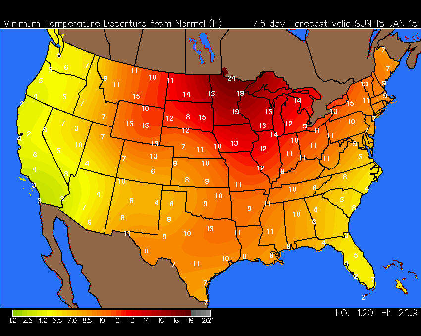
Here are some of the temperature forecasts for the coming thaw.
Keep in mind that sometimes models go too warm this far out then back down a bit as we get closer to the time frame in question. They have been doing that for the last 2 months. So, don’t expect to break out the shorts! A January thaw might mean highs in the 40’s.
Normal high temperature for this time of the year? 41 degrees
Normal low temperatures for this time of the year? 23 degrees
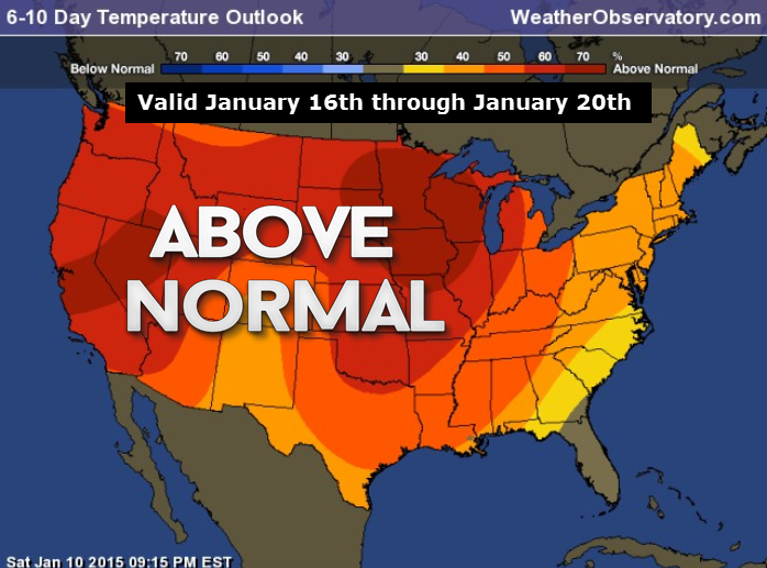
This is where odds favor above normal temperatures. The whole nation!


Let’s poke around the data a bit more
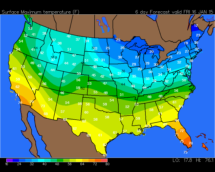
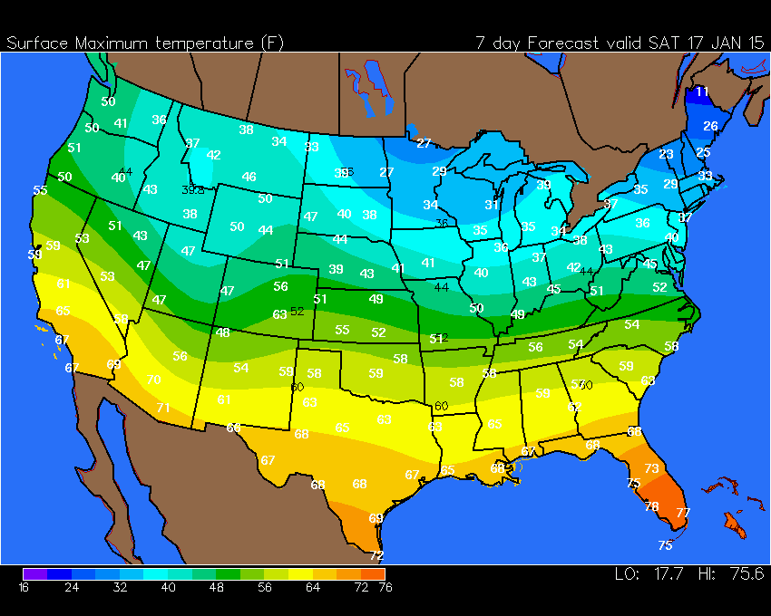
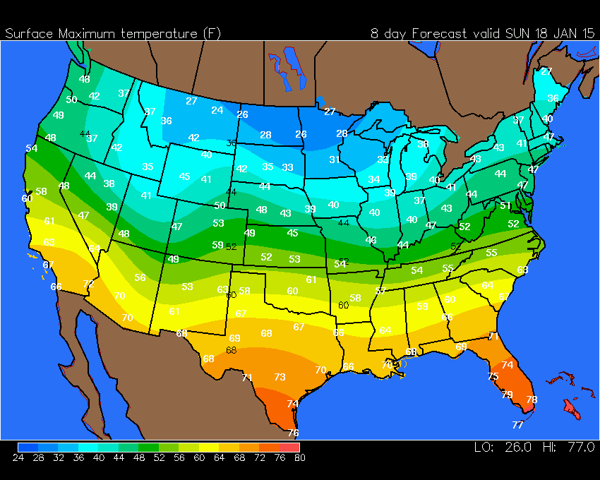
Here are some maps from www.wright-weather.com
Click images for a larger view
FRIDAY FORECAST HIGH TEMPERATURES
SATURDAY FORECAST HIGH TEMPERATURES
SUNDAY FORECAST HIGH TEMPERATURES
By next Sunday let’s see how much above normal those temperatures would be. Quite a few degrees (for the whole NATION)
These are the low temperature departures. In other words, how many degrees above normal will low temperatures be on Sunday.
Normal high temperature for this time of the year? 41 degrees
Normal low temperatures for this time of the year? 23 degrees
What about high temperature departures? Here you go 🙂
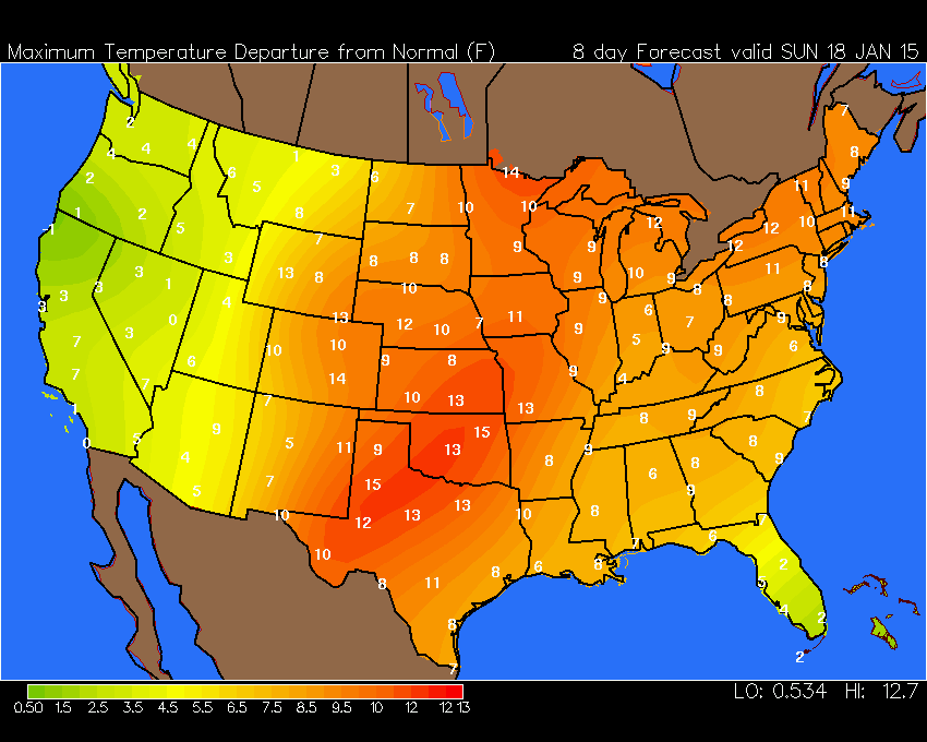
Again, not talking about beach weather here! But, at least it won’t be in the single digits. No complaints?

We have regional radars and local city radars – if a radar does not seem to be updating then try another one. Occasional browsers need their cache cleared. You may also try restarting your browser. That usually fixes the problem. Occasionally we do have a radar go down. That is why I have duplicates. Thus, if one fails then try another one.
If you have any problems then please send me an email beaudodson@usawx.com
WEATHER RADAR PAGE – Click here —
We also have a new national interactive radar – you can view that radar by clicking here.
Local interactive city radars include St Louis, Mt Vernon, Evansville, Poplar Bluff, Cape Girardeau, Marion, Paducah, Hopkinsville, Memphis, Nashville, Dyersburg, and all of eastern Kentucky – these are interactive radars. Local city radars – click here
NOTE: Occasionally you will see ground clutter on the radar (these are false echoes). Normally they show up close to the radar sites – including Paducah.

Regional Radar – Click on radar to take you our full radar page.


Regional Radar
![]()
Current WARNINGS (a warning means take action now). Click on your county to drill down to the latest warning information. Keep in mind that there can be a 2-3 minute delay in the updated warning information.
I strongly encourage you to use a NOAA Weather Radio or warning cell phone app for the most up to date warning information. Nothing is faster than a NOAA weather radio.


Color shaded counties are under some type of watch, warning, advisory, or special weather statement. Click your county to view the latest information.

Missouri Warnings

Illinois Warnings

Kentucky Warnings

Please visit your local National Weather Service Office by clicking here. The National Weather Service Office, for our region, is located in Paducah, Kentucky.

Here is the official 6-10 day and 8-14 day temperature and precipitation outlook. Check the date stamp at the top of each image (so you understand the time frame).
The forecast maps below are issued by the Weather Prediction Center (NOAA).
Many of my graphics are from www.weatherbell.com – a great resource for weather data, model data, and more


This blog was inspired by ABC 33/40’s Alabama Weather Blog – view their blog
Current tower cam view from the Weather Observatory- Click here for all cameras.

Southern Illinois Weather Observatory

The Weather Observatory

Southern Illinois Weather Observatory
WSIL TV 3 has a number of tower cameras. Click here for their tower camera page & Illinois Road Conditions

Marion, Illinois
WPSD TV 6 has a number of tower cameras. Click here for their tower camera page & Kentucky Road Conditions & Kentucky Highway and Interstate Cameras

Downtown Paducah, Kentucky
Benton, Kentucky Tower Camera – Click here for full view

Benton, Kentucky

I24 Paducah, Kentucky

I24 Mile Point 9 – Paducah, KY

I24 – Mile Point 3 Paducah, Kentucky

You can sign up for my AWARE email by clicking here I typically send out AWARE emails before severe weather, winter storms, or other active weather situations. I do not email watches or warnings. The emails are a basic “heads up” concerning incoming weather conditions.