3 PM Update
Sunday Evening Update – Rain rain rain for most areas.
Temperatures have been 3-6 degrees warmer than forecast today over much of southeast Missouri and southern Illinois. Thus, what should have been sleet and freezing rain has been plain old rain. This spared a large chunk of our region from problems.
Areas from Arkansas into southern Missouri and into central Illinois are dealing with a LOT of accidents as ice continues in some of those areas.
Some accidents in southeast Missouri were reported because of ice earlier this morning.
This was a tough forecast (as you know). I never could quite figure out where to put the 32 degree line. The closest I ever got to being close was the very first forecast map.
Rain will continue overnight. Temperatures may fall a couple of degrees, but should not fall too much.
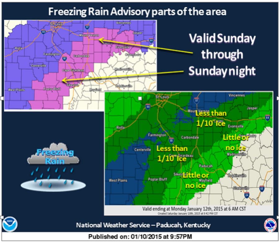
The National Weather Service is going to cancel the freezing rain advisory for some counties. They will leave it for others. I will post a map in a bit.
The counties being cancelled are Scott [MO] and Alexander, Edwards, Gallatin, Hamilton, Johnson, Pulaski, Saline, Wabash, Wayne, White [IL] and Gibson, Pike, Posey, Spencer, Vanderburgh, Warrick [IN]
Started talking about this system for than a week and a half ago. Nailed the precipitation event, but missed the precipitation type for most areas. Well, at least the forecast in western Kentucky and far southern Illinois went well.
Precipitation will end tomorrow as temperatures fall. Small chance for a brief period of frozen precipitation at the very end. But, the atmosphere should dry out pretty quick as the cold air moves in. Will monitor that in case some freezing drizzle forms.
A JANUARY THAW is showing up towards the end of the week into the following week. More on that in tomorrow’s blog update.
10 AM Update
Numerous accidents are being reported over southeast Missouri. Freezing rain is causing roadways to become covered in a thin layer of ice. Temperatures are hovering around freezing in the advisory area. Butler County, Carter County, Stoddard County, and some of the surrounding counties are reporting freezing rain and some sleet pellets.
Temperatures over southern Illinois and in the lower to middle 30’s. Temperatures may fall a few degrees as precipitation falls into the dry air mass. Evaporational cooling.
Temperatures are MUCH warmer this morning than anticipated over the region. This raises some questions as to how long the freezing rain will last in some of the advisory area. With that said…road conditions are very cold. Surfaces are cold. We had single digits over the past several days. Thus, ice may form even where temperatures have risen a bit above freezing.
No change in the forecast for western Kentucky. Mostly a rain event. Small chance of a wintry mix at the start. Then all rain for west KY and NW TN.
Freezing rain will change to rain over parts of southeast Missouri and southern Illinois, as well.
Best chance for prolonged periods of freezing rain will be from Poplar Bluff towards Randolph County, Illinois and over towards Mt Vernon and northward.
It only takes a SMALL amount of freezing rain to cause serious road problems.
– Beau
We have our first sponsor for the blog. Milner and Orr Funeral Home and Cremation Services located in Paducah, Kentucky and three other western Kentucky towns – at Milner and Orr they believe in families helping families.
![]()

This forecast update covers far southern Illinois, far southeast Missouri, and far western Kentucky. See the coverage map on the right side of the blog.
Sunday – Cloudy today. Raw and chilly. Periods of light rain, freezing rain, and sleet developing from the southwest and spreading northeast. Temperatures today will be in the lower to middle 30’s. South winds at 5-10 mph. Best chance of frozen precipitation will be over parts of southeast Missouri and southern Illinois. A brief window of opportunity for frozen precipitation in western Kentucky.
Areas that experience freezing rain or sleet may change to all rain over parts of southeast Missouri and southern Illinois as well. Road temperatures are cold. Even with temperatures slightly above freezing there may be issues for a few hours. This is especially true on side roads and untreated roadways.
All of the overnight data came in about 2-4 degrees warmer for today and tonight. That may be just enough to save many areas from a lot of problems.
Precipitation Radar With Precipitation Type Option – Click here —
Sunday night – Chilly and raw. Rain for much of the area – a chance that rain will change back to freezing rain across parts of southeast Missouri and southern Illinois (areas that are experiencing temperatures near the freezing mark and areas that changed over to rain). Low temperatures in the lower to middle 30’s. South winds at 5-10 mph. Winds may turn out of the north late at night.
Monday – Precipitation will come to an end on Monday morning. It will be cold with high temperatures only in the 30’s. Falling temperatures into the 20’s during the afternoon hours. North winds at 10-20 mph. These winds will make it feel colder. Wind chills during the morning hours will be in the upper teens and lower 20’s. Wind chills by evening will be in the single digits to lower teens.
MEDIUM CONFIDENCE in this forecast…

Current Temperatures Around The Local Area


An explanation of what is happening in the atmosphere over the coming days.
Click for larger view.
This has not been an easy forecast when it comes to details. I started telling you about this system over a week ago! But, the details have always been the hard part. That remains true this morning.
All of the overnight data came in a few degrees warmer for today and tonight. That may be just enough to save many areas from a lot of problems.
Precipitation will develop over the area this morning – first over southeast Missouri and northeast Arkansas. The precipitation will then spread northeast into Illinois and Kentucky. Early on the precipitation should be light and perhaps in a thin band or two on radar. Early on we may see a mixture of sleet and freezing rain changing to rain. The frozen precipitation would linger the longest over parts of SE MO and southern IL.
Precipitation coverage will increase dramatically this afternoon and into tonight. Intensity of the precipitation will also pick up just a bit.
Temperatures should rise above freezing over most of western Kentucky by this afternoon. That means mostly rain for western Kentucky. Perhaps a brief window of opportunity for a wintry mix. But, mainly rain.
Southeast Missouri and southern Illinois will not be quite as clear cut when it comes to the temperature part of the forecast. As I have been mentioning for a few days now…temperatures are likely going to hover near freezing through most of this event for the Missouri Ozarks – eastern Missouri and much of southern Illinois. That means temperatures might be in the 31 to 34 degree range. That makes for a tricky call on whether freezing rain will fall or just plain old rain.
The further south in Illinois you travel the more likely this will be mostly a rain event. Areas near the Ohio River should be mostly rain. Perhaps a brief window of opportunity for a wintry mix early on. Then it should change over to just plain rain.
Areas from around Poplar Bluff, Missouri up towards Cape Girardeau County, Missouri towards Carbondale, Illinois and up towards Shawneetown, Illinois should see temperatures around freezing – perhaps even a few degrees above freezing at times. Freezing rain will be possible in these areas northward…until temperatures rise a bit. Just south of there periods of freezing rain will also occur. Again, tricky on pinpointing the exact change-over area.
Areas further north – near St Louis and north of Mt Vernon will likely remain freezing rain.
Temperatures tonight (Sunday night) might fall a degree or two. Areas that are near freezing may drop below freezing once again.
The main impact from this event is going to be slick roadways. Small amounts of freezing rain can cause a lot of accidents. People get a little over confident when it comes to small amounts of precipitation. If that precipitation is freezing rain then you have a recipe for trouble. Untreated roadways can become a skating rink. Use caution if you must travel in areas where temperatures do not rise above freezing.
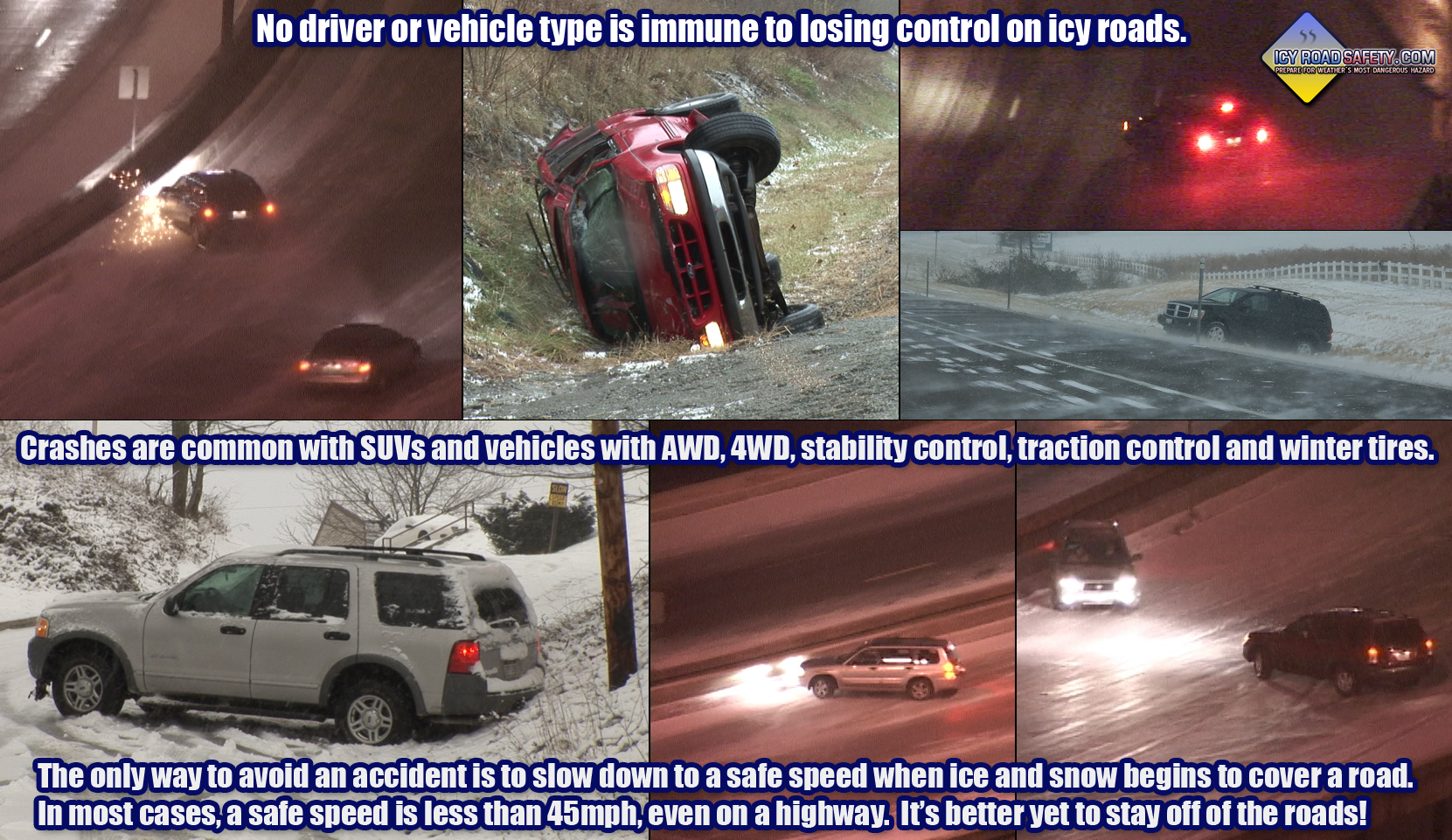
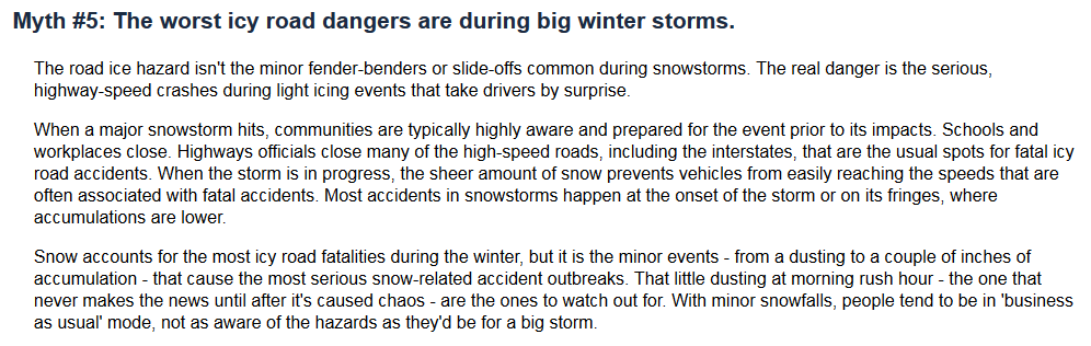
Myth about icy road dangers. Worth reading. Click for larger view.
The National Weather Service has issued an assortment of weather advisories warning travelers that roads may become icy across parts of our area. See those maps below and click on them for details.
Complicated forecast. Saw this system coming many many days ago. Just did not know how it would play out. Quite amazing how tricky it has been to forecast temperatures. Even at this late hour there remain questions on whether temperatures will rise above freezing across much of southeast Missouri and southern Illinois.
We have a new sponsor! G&C Multi-Services out of Paducah, Kentucky. G & C Multi-Services is a service provider in Western Kentucky that provides industrial and commercial equipment fabrication, machine troubleshooting, repair and maintenance, and installation. They can custom fabricate steel, stainless, and aluminum products per customer specifications.
Visit their web-site here. Or click the ad below! They have a Facebook page and it can be viewed here.

From the Paducah, KY National Weather Service Office

Here is how the NWS out of Paducah draws their lines
The snow system for the middle of the week seems to be too far south for much of an impact on our region. I will continue to monitor it over the coming days. A January thaw is appearing in the charts for later this week into the next week.
We may have another storm system early next week.

Concerns in today’s update are centered around freezing rain. Some areas will remain all rain (as mentioned above). Areas that do have a period of sleet and freezing rain will have slick roadways and sidewalks. Historically events like this can cause ER’s to fill up pretty fast with broken bones and sprains from people slipping on icy sidewalks.
If you are in the ice area then please use care.
Historically events like this cause a large number of car accidents. People tend to look out the window and think that it isn’t that bad because precipitation has been light. Light amounts of freezing rain can cause big problems on untreated roadways. Use care if you are in an area experiencing freezing rain.

The wild card tells you where the most uncertainty is in the current forecast.
Wild card in this forecast – this is an easy one! The wild card centers around the placement of the freezing rain (ice) line vs the rain line. Still, at this time, there are questions on this subject. Mainly over SE Missouri and southern Illinois. The data has been trending a few degrees warmer. A few degrees is all we need to avoid problems in some of our counties.

Will I need to take action?
Use care if are in one of the counties experiencing ice.
The rest of us will just need our umbrellas and a coat. Nothing worse than cold rain. Blah

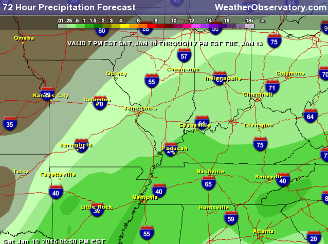
How much rain should this system produce over our region?
Precipitation totals should be in the 0.25″ to 0.50″ range. Some of the data paints higher totals. Here is the current rainfall forecast map.

We have regional radars and local city radars – if a radar does not seem to be updating then try another one. Occasional browsers need their cache cleared. You may also try restarting your browser. That usually fixes the problem. Occasionally we do have a radar go down. That is why I have duplicates. Thus, if one fails then try another one.
If you have any problems then please send me an email beaudodson@usawx.com
WEATHER RADAR PAGE – Click here —
We also have a new national interactive radar – you can view that radar by clicking here.
Local interactive city radars include St Louis, Mt Vernon, Evansville, Poplar Bluff, Cape Girardeau, Marion, Paducah, Hopkinsville, Memphis, Nashville, Dyersburg, and all of eastern Kentucky – these are interactive radars. Local city radars – click here
NOTE: Occasionally you will see ground clutter on the radar (these are false echoes). Normally they show up close to the radar sites – including Paducah.

Regional Radar – Click on radar to take you our full radar page.


Regional Radar
![]()
Current WARNINGS (a warning means take action now). Click on your county to drill down to the latest warning information. Keep in mind that there can be a 2-3 minute delay in the updated warning information.
I strongly encourage you to use a NOAA Weather Radio or warning cell phone app for the most up to date warning information. Nothing is faster than a NOAA weather radio.


Color shaded counties are under some type of watch, warning, advisory, or special weather statement. Click your county to view the latest information.

Missouri Warnings

Illinois Warnings

Kentucky Warnings

Please visit your local National Weather Service Office by clicking here. The National Weather Service Office, for our region, is located in Paducah, Kentucky.

Here is the official 6-10 day and 8-14 day temperature and precipitation outlook. Check the date stamp at the top of each image (so you understand the time frame).
The forecast maps below are issued by the Weather Prediction Center (NOAA).


The latest 8-14 day temperature and precipitation outlook. Note the dates are at the top of the image. These maps DO NOT tell you how high or low temperatures or precipitation will be. They simply give you the probability as to whether temperatures or precipitation will be above or below normal.


Many of my graphics are from www.weatherbell.com – a great resource for weather data, model data, and more


This blog was inspired by ABC 33/40’s Alabama Weather Blog – view their blog
Current tower cam view from the Weather Observatory- Click here for all cameras.

Southern Illinois Weather Observatory

The Weather Observatory

Southern Illinois Weather Observatory
WSIL TV 3 has a number of tower cameras. Click here for their tower camera page & Illinois Road Conditions

Marion, Illinois
WPSD TV 6 has a number of tower cameras. Click here for their tower camera page & Kentucky Road Conditions & Kentucky Highway and Interstate Cameras

Downtown Paducah, Kentucky
Benton, Kentucky Tower Camera – Click here for full view

Benton, Kentucky

I24 Paducah, Kentucky

I24 Mile Point 9 – Paducah, KY

I24 – Mile Point 3 Paducah, Kentucky

You can sign up for my AWARE email by clicking here I typically send out AWARE emails before severe weather, winter storms, or other active weather situations. I do not email watches or warnings. The emails are a basic “heads up” concerning incoming weather conditions.