
We have our first sponsor for the blog. Milner and Orr Funeral Home and Cremation Services located in Paducah, Kentucky and three other western Kentucky towns – at Milner and Orr they believe in families helping families.
![]()

This forecast update covers far southern Illinois, far southeast Missouri, and far western Kentucky. See the coverage map on the right side of the blog.
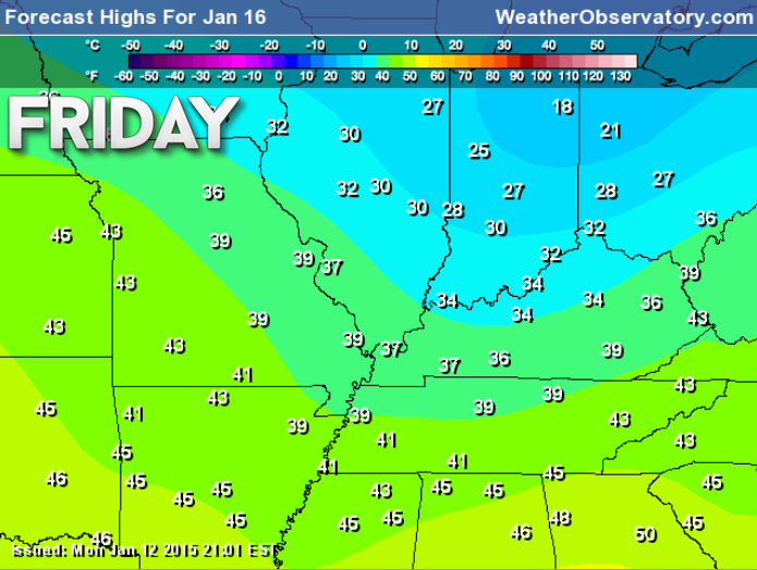
Tuesday – Quite a few clouds. A stray flurry. It will be on the chilly side. But, not bad compared to what happened last week. High temperatures will be in the upper 20’s and lower 30’s North winds at 5-10 mph.
Morning School Bus Stop Weather – Quite a few clouds and chilly. Temperatures will be in the lower 20’s. North winds at 5 mph.
Afternoon School Bus Stop Weather – Quite a few clouds and chilly. Temperatures will be in the upper 20’s. North winds at 5 mph.
Tuesday night – Clearing and cold. Low temperatures around 14-18 degrees. North winds at 5-10 mph.
Wednesday – An increase in clouds. Chilly. Small chance for a flurry. High temperatures in the upper 20’s and lower 30’s. North winds at 5-10 mph.
Wednesday night – Cloudy with a small chance for a flurry. Low temperatures around 18-22 degrees. North winds at 5 mph.
Thursday – A mix of sun and clouds. Not as cold. High temperatures in the upper 30’s. Winds will become west during the morning and then southwest by the afternoon. This is the signal that we may start to see moderating temperatures as we push later into the work week and weekend.

Current Temperatures Around The Local Area


An explanation of what is happening in the atmosphere over the coming days.
Chilly but calm. That about sums up the weather for the next few days. Nothing too dramatic to follow. A weak weather disturbance will quietly move through the region on Wednesday. It will bring some clouds and at the most a flurry. Chilly temperatures, as well.
Overall, high pressure is going to dominate our weather pattern through the end of the week. As this high pulls away to our east we will see winds turn out of the south. Once the southerly flow begins we can expect moderating temperatures. This is good news for those who are tired of the cold air.
By the weekend temperatures should be in the 40’s and maybe even 50’s.
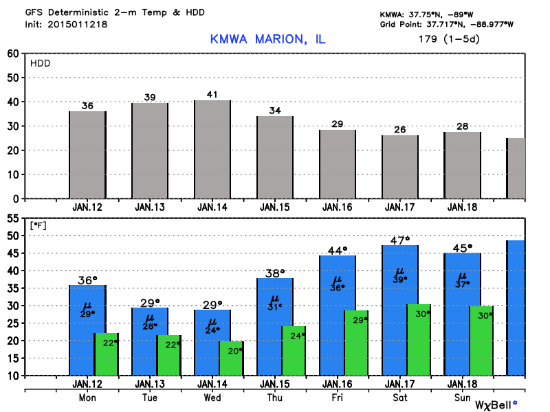
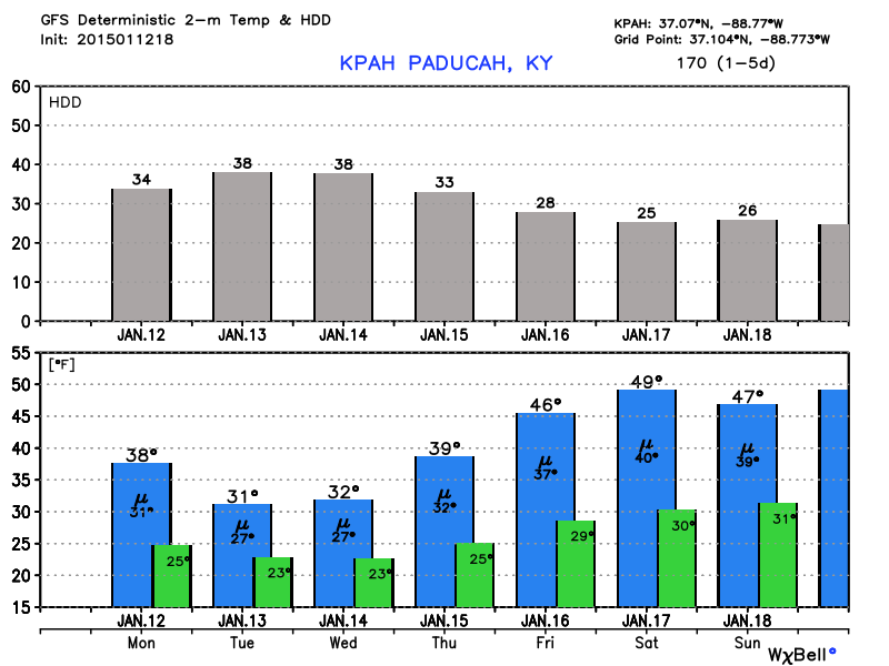
Here are the temperature graphs for the next 7 days. The first one is for Marion, Illinois and the second one is for Paducah, Kentucky. Can we reach 50 this weekend? Hmmm
Images are from www.weatherbell.com
The blue bar is the high temperature
The green bar is the low temperature
The gray bars at the top are the heating degree days
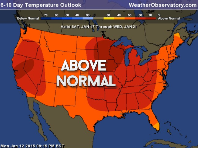
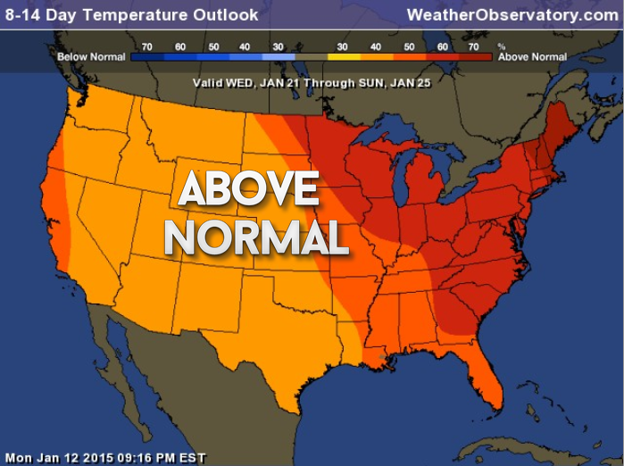
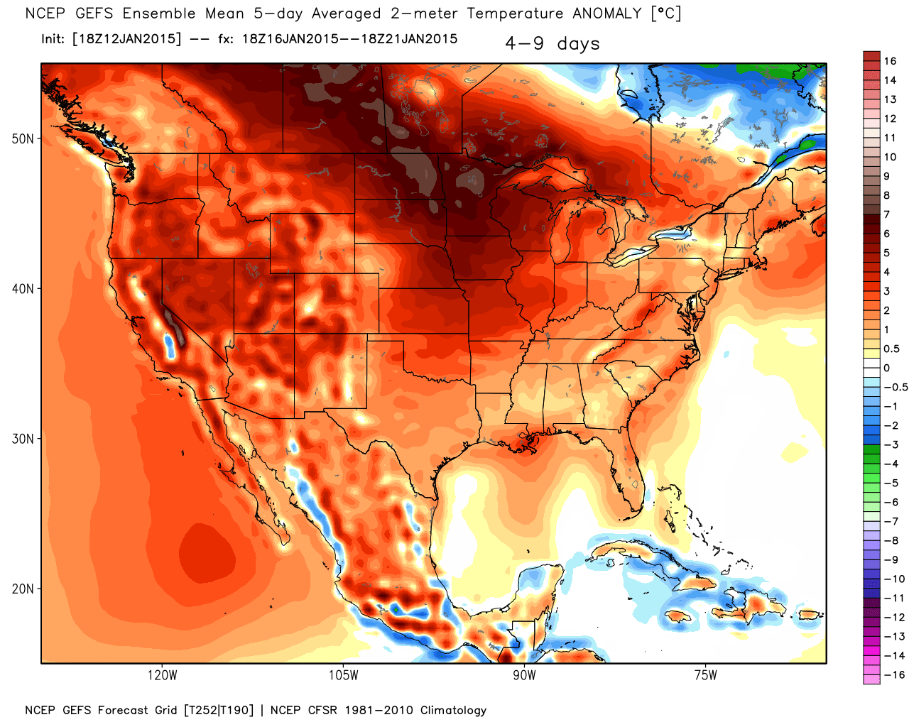
Let’s take a look at the latest temperature outlook for the coming 6-14 days. These maps tell you if odds favor temperatures being above or below normal.
Normal high temperature for this time of the year? 41 degrees
Normal low temperatures for this time of the year? 23 degrees
This is where odds favor above normal temperatures. The whole nation!
Let’s zero in on that just a bit more and break it down in 5 day chunks. These maps below show you how many degrees above normal temperatures might be. The above maps only showed you were odds favored temperatures being above normal. Now let’s look at how many degrees above normal.
Images are from www.weatherbell.com
Remember that I told you the average readings for this time of the year are
Normal high temperature for this time of the year? 41 degrees
Normal low temperatures for this time of the year? 23 degrees
January 16th-21st
Click image for larger view
January 23rd through the 28th
Click image for larger view
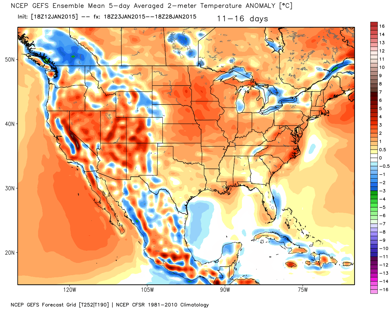
According to the ensembles the rest of the month will bring above normal temperatures.
Now, I am not totally sold on that happening. Certainly the end of this week into part of next week. But, there are some signals that a system towards the middle or end of next week may bring some colder temperatures back to the region. This is a wait and see…for now.

No major changes to the ongoing forecast.

I don’t have any major concerns!

The wild card tells you where the most uncertainty is in the current forecast.
Wild card in this forecast – I don’t have a wild card in today’s forecast. Fairly calm day ahead of us.

Can we expect severe thunderstorms over the next 24 to 48 hours? Remember that a severe thunderstorm is defined as a thunderstorm that produces 58 mph winds or higher, quarter size hail or larger, and/or a tornado.
Thunderstorm threat level is ZERO


Will I need to take action?
No significant weather today or tonight.

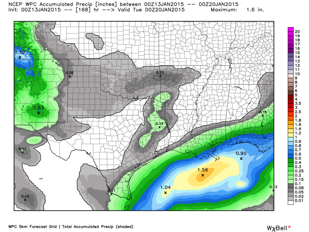
How much rain should this system produce over our region?
No rain or significant snow in the forecast through Friday. Fairly calm weather.
This is the official precipitation forecast through next Tuesday. YAWN!
Image from www.weatherbell.com
We have a new sponsor for WeatherTalk! G&C Multi-Services out of Paducah, Kentucky. G & C Multi-Services is a service provider in Western Kentucky that provides industrial and commercial equipment fabrication, machine troubleshooting, repair and maintenance, and installation. They can custom fabricate steel, stainless, and aluminum products per customer specifications.
Visit their web-site here. Or click the ad below! They have a Facebook page and it can be viewed here.


No significant winter weather. Sorry team snow! Just not happening for you. Patient? I know you are running out of patience and winter. Meteorological spring begins March 1st. The countdown has begun.
Maybe some flurries on Wednesday as a weak disturbance slides through our region. Not much moisture to work with. Does not look to be a big deal.

How about the weekend?
Well, how about some warmer temperatures! Okay, I am using the word “warmer” a bit loosely. BUT – at least moderating temperatures are a sure bet.
Is that applause and wild cheers that I am hearing?

Still chilly on Friday…but wait for it 🙂
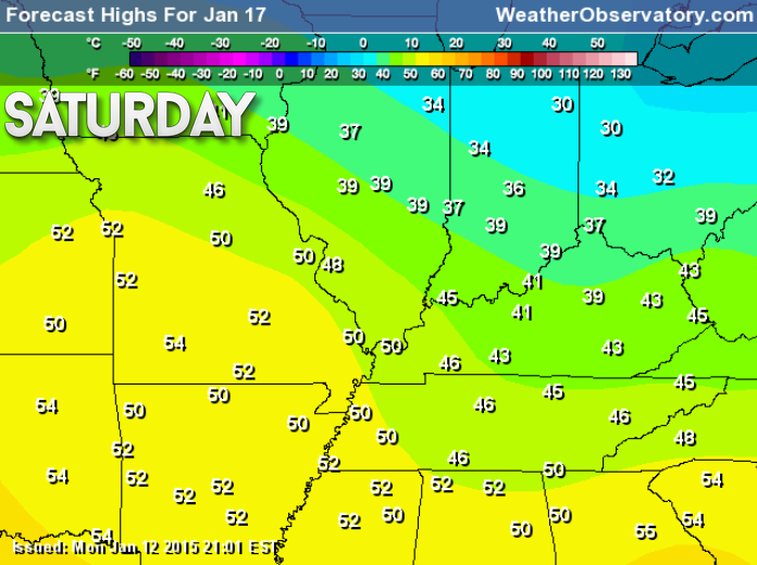
Saturday Temperatures
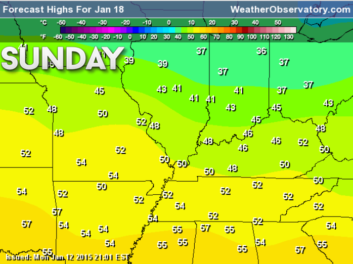
Sunday Temperatures
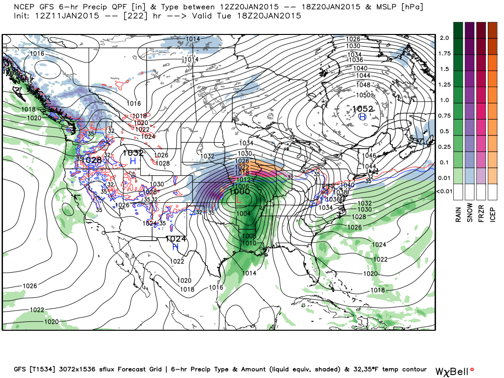
Remember that system we were watching on the GFS model yesterday? Let’s take a look at that same map today.
This is what the model showed yesterday – an intense storm system approaching our region with thunderstorms. All of that green would be heavy rain and thunderstorms. The blue back in Kansas would be heavy snow or even blizzard conditions. Strong low over southwest Missouri moving northeast.
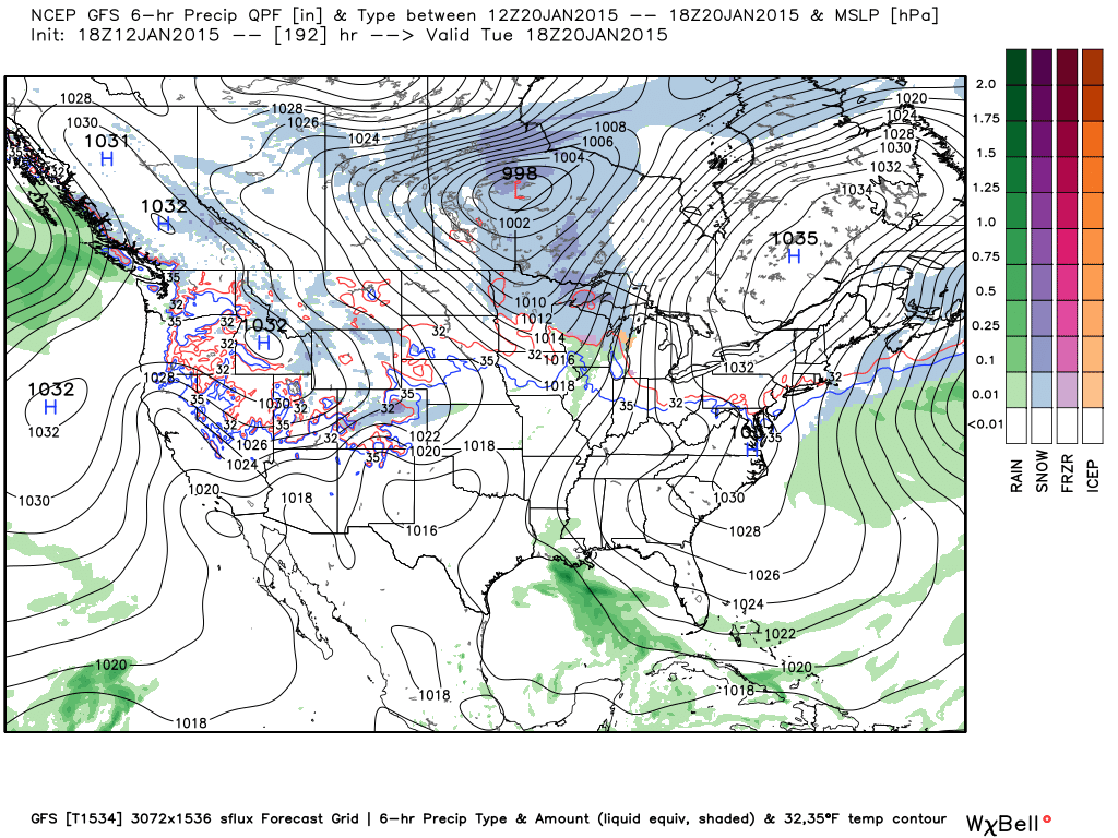
Now today – this is what that same model is showing. Poof it is gone 🙂 – this is why I tell you that the models in the long range can’t be trusted. Will it bring it back in future runs? We shall see. The idea of energy still being out west and moving east is certainly there.
The GFS is now showing that system coming in later next week. This is for Thursday. So, it still has a system. It has pushed it off a few days. Also a colder system. We will keep watching it and see what happens. Something to monitor, at least. Let’s check back tomorrow and see what the data shows!
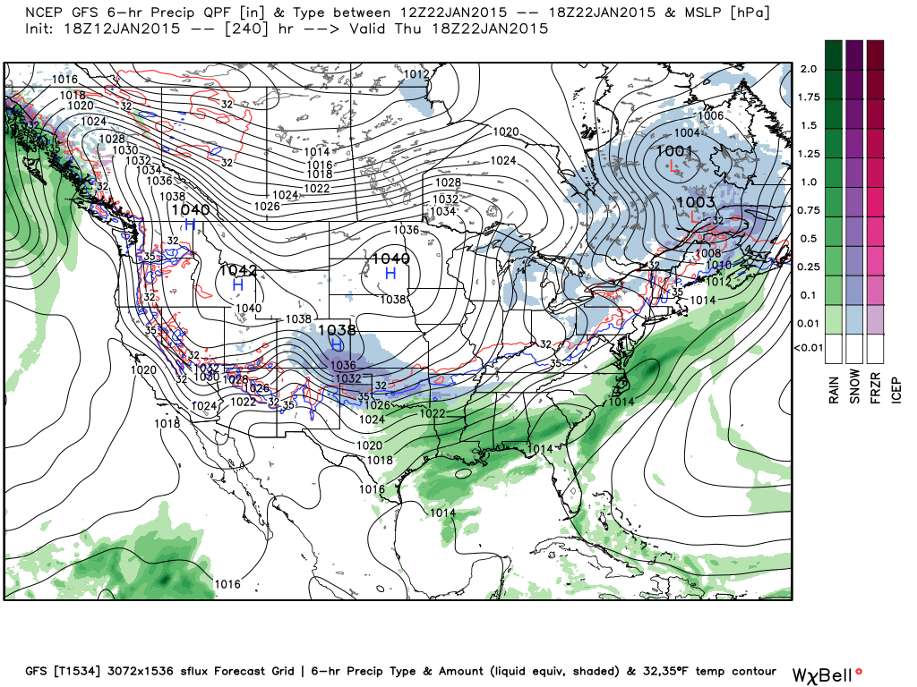
This system below for January 22nd looks colder than earlier model solutions. So, snow fans – don’t give up hope.

We have regional radars and local city radars – if a radar does not seem to be updating then try another one. Occasional browsers need their cache cleared. You may also try restarting your browser. That usually fixes the problem. Occasionally we do have a radar go down. That is why I have duplicates. Thus, if one fails then try another one.
If you have any problems then please send me an email beaudodson@usawx.com
WEATHER RADAR PAGE – Click here —
We also have a new national interactive radar – you can view that radar by clicking here.
Local interactive city radars include St Louis, Mt Vernon, Evansville, Poplar Bluff, Cape Girardeau, Marion, Paducah, Hopkinsville, Memphis, Nashville, Dyersburg, and all of eastern Kentucky – these are interactive radars. Local city radars – click here
NOTE: Occasionally you will see ground clutter on the radar (these are false echoes). Normally they show up close to the radar sites – including Paducah.

Regional Radar – Click on radar to take you our full radar page.


Regional Radar
![]()
Current WARNINGS (a warning means take action now). Click on your county to drill down to the latest warning information. Keep in mind that there can be a 2-3 minute delay in the updated warning information.
I strongly encourage you to use a NOAA Weather Radio or warning cell phone app for the most up to date warning information. Nothing is faster than a NOAA weather radio.


Color shaded counties are under some type of watch, warning, advisory, or special weather statement. Click your county to view the latest information.

Missouri Warnings

Illinois Warnings

Kentucky Warnings

Please visit your local National Weather Service Office by clicking here. The National Weather Service Office, for our region, is located in Paducah, Kentucky.
Many of my graphics are from www.weatherbell.com – a great resource for weather data, model data, and more


This blog was inspired by ABC 33/40’s Alabama Weather Blog – view their blog
Current tower cam view from the Weather Observatory- Click here for all cameras.

Southern Illinois Weather Observatory

The Weather Observatory

Southern Illinois Weather Observatory
WSIL TV 3 has a number of tower cameras. Click here for their tower camera page & Illinois Road Conditions

Marion, Illinois
WPSD TV 6 has a number of tower cameras. Click here for their tower camera page & Kentucky Road Conditions & Kentucky Highway and Interstate Cameras

Downtown Paducah, Kentucky
Benton, Kentucky Tower Camera – Click here for full view

Benton, Kentucky

I24 Paducah, Kentucky

I24 Mile Point 9 – Paducah, KY

I24 – Mile Point 3 Paducah, Kentucky

You can sign up for my AWARE email by clicking here I typically send out AWARE emails before severe weather, winter storms, or other active weather situations. I do not email watches or warnings. The emails are a basic “heads up” concerning incoming weather conditions.