We have some great sponsors for the Weather Talk Blog. Please let our sponsors know that you appreciate their support for the Weather Talk Blog.
Milner and Orr Funeral Home and Cremation Services located in Paducah, Kentucky and three other western Kentucky towns – at Milner and Orr they believe in families helping families. You can find Milner and Orr on Facebook, as well.
![]()
.

For all of your families eye care needs. Visit their web-site here. Or, you can also visit their Facebook page.
.

Best at Enabling Body Shop Profitability since 1996. Located In Paducah Kentucky and Evansville Indiana; serving all customers in between. They provide Customer Service, along with all the tools necessary for body shops to remain educated and competitive. Click the logo above for their main web-site. You can find McClintock Preferred Finishes on Facebook, as well
.

Duck/goose decoys? Game calls? Optics? We have you covered! Click the logo above or visit Final Flight on Facebook, as well.
.
I have launched the new weather texting service! I could use your help. Be sure and sign up and fully support all of the weather data you see each day.
This is a monthly subscription service. Supporting this helps support everything else. The cost is $3 a month for one phone, $5 a month for three phones, and $10 a month for seven phones.
For more information visit BeauDodsonWeather.com
Or directly sign up at Weathertalk.com


This forecast update covers far southern Illinois, far southeast Missouri, and far western Kentucky. See the coverage map on the right side of the blog.
Remember that weather evolves. Check back frequently for updates, especially during active weather.

Winter Weather Radars
WEATHER RADAR PAGE – Click here —
Monday Night – Cloudy and windy. Snow showers likely. Wind chills in the single digits to lower teens.
Temperatures: Lows from 18 to 24 degrees. Wind chills will dip into the single digits.
Winds: Northwest winds at 8-16 mph with gusts above 25 mph
What is the chance for precipitation? 70%
Coverage of precipitation? Scattered
My confidence in this part of the forecast verifying is High
Should I be concerned about snow or ice? Some snow showers possible. Light accumulation can’t be ruled out.
Should I cancel my outdoor plans? Have alternative plans. Bitterly cold air, low wind chills, and maybe some snow showers will not make for the best outdoor weather conditions.
Is severe weather expected? No
What impact is expected? Maybe some snow showers. Light accumulation possible. Low wind chill values.
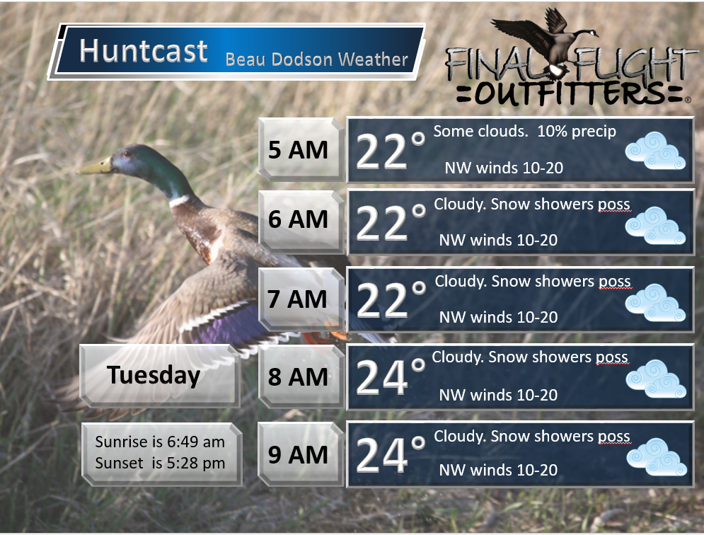
Tuesday – Cloudy and cold. Light snow showers possible. Wind chills in the single digits to lower teens.
Temperatures: Highs will range 24 to 28 degrees
Winds: Northwest winds at 10-20 mph. Gusty winds, at times.
What is the chance for precipitation? 40%
Coverage of precipitation? Scattered
My confidence in this part of the forecast verifying is Medium
Should I be concerned about snow or ice? Monitor updates
Should I cancel my outdoor plans? Not the best outdoor conditions.
Is severe weather expected? No
What impact is expected? Perhaps some snow showers. Light accumulation possible. Low wind chill values.
Tuesday Night – Some decrease in cloud cover. Cold. Wind chills in the single digits. Bitterly cold.
Temperatures: Lows from 10-16 degrees
Winds: Northwest winds at 4-8 mph with gusts to 20 mph.
What is the chance for precipitation? 10%
Coverage of precipitation? Isolated
My confidence in this part of the forecast verifying is High
Should I be concerned about snow or ice? Not likely
Should I cancel my outdoor plans? No
Is severe weather expected? No
What impact is expected? Suspect light snow showers will have ended by Tuesday night. Low wind chill values.
Wednesday – Partly to mostly sunny. Cold.
Temperatures: Highs will range 24-28 degrees
Winds: Northwest winds at 5-10 mph. Gusts of 15-20 mph possible.
What is the chance for precipitation? 0%
Coverage of precipitation? None
My confidence in this part of the forecast verifying is High
Should I be concerned about snow or ice? No
Should I cancel my outdoor plans? No
Is severe weather expected? No
What impact is expected? Low wind chill values.
Wednesday Night – Cloudy. Light snow possible.
Temperatures: Lows from 12-16 degrees
Winds: Northeast winds at 5-10 mph
What is the chance for precipitation? 40%-60%
Coverage of precipitation? Scattered. Perhaps a narrow band of light snow from northwest to southeast over the area.
My confidence in this part of the forecast verifying is Medium
Should I be concerned about snow or ice? Yes, some snow possible.
Should I cancel my outdoor plans? No
Is severe weather expected? No
What impact is expected? Bitterly cold air. Snow possible. Slick roads possible. Light accumulation possible.
Thursday – Some clouds. Morning light snow possible. Then, becoming partly cloudy. Cold.
Temperatures: Highs will range 26-32 degrees. Warmest temperatures over western parts of southeast Missouri. Poplar Bluff might reach 36-38 degrees.
Winds: North and northeast winds at 6-12 mph.
What is the chance for precipitation? 40% early.
Coverage of precipitation? Scattered
My confidence in this part of the forecast verifying is Medium
Should I be concerned about snow or ice? Some morning light snow possible. Narrow band over the area.
Should I cancel my outdoor plans? No
Is severe weather expected? No
What impact is expected? Some slick spots possible on roadways.
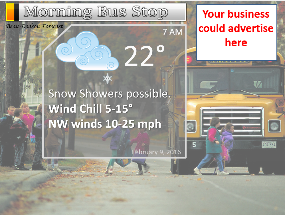
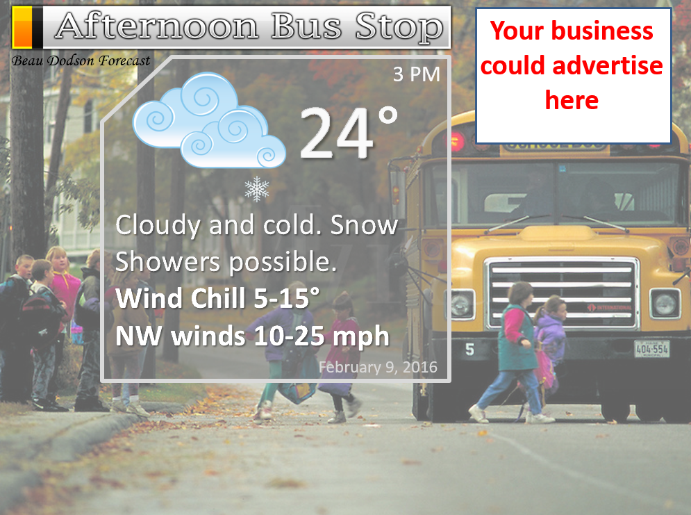
We still have the school bus stop forecast AD spot available 🙂

Don’t forget to check out the Southern Illinois Weather Observatory web-site for weather maps, tower cams, scanner feeds, radars, and much more! Click here

An explanation of what is happening in the atmosphere over the coming days…
Highlights
1. Cold to bitterly cold air over the coming days
2. Gusty winds and low wind chills
3. Scattered snow showers
4. Another shot of cold air this weekend?
Winter Weather Radars
WEATHER RADAR PAGE – Click here –
The main weather story will be the cold air and gusty winds. The combination of the two will produce very cold wind chill values. This will last into Wednesday morning. Wind chill values in the single digits will be common. Bundle up weather! Brrrr!
Snow showers will also be with us into Tuesday evening. Light accumulation can’t be ruled out in a few spots. But, overall, this is a light and disorganized event. Not a major winter storm.
Where a band or two of snow showers persist over one area you could have a quick burst of accumulating snow. And, if that happens, then a few slick spots would be possible. This is a dry snow. It will blow around quite a bit. Thus, problems should be mitigated.
Tuesday morning lows will be chilly (wind chills will be even colder)
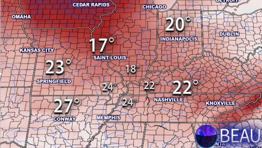
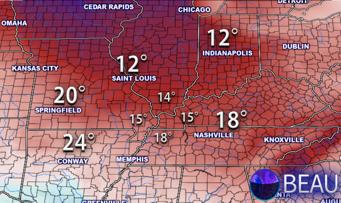
Both Wednesday and Thursday morning will see temperatures dipping into the upper single digits to middle teens. Brrrr
Here is the Wednesday morning low temperature map (some spots will be colder).
Not much of a warming trend in the charts. Another reinforcing shot of cold air is showing up for Saturday or Sunday. Cold weather may be with us for awhile.
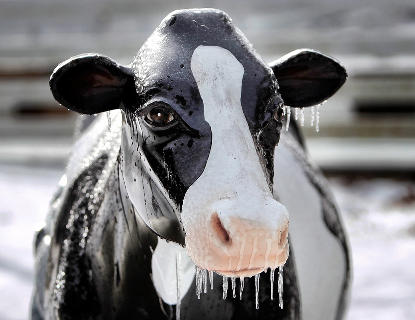
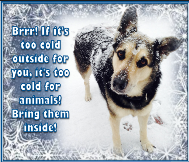
Don’t forget about our outdoor friends
I am watching a precipitation event around the 14th-16th and then around the 20th. Give or take. Guidance has been showing a stronger event for the 20th. But, that is a long way off for any confidence. I will keep monitoring the trends.
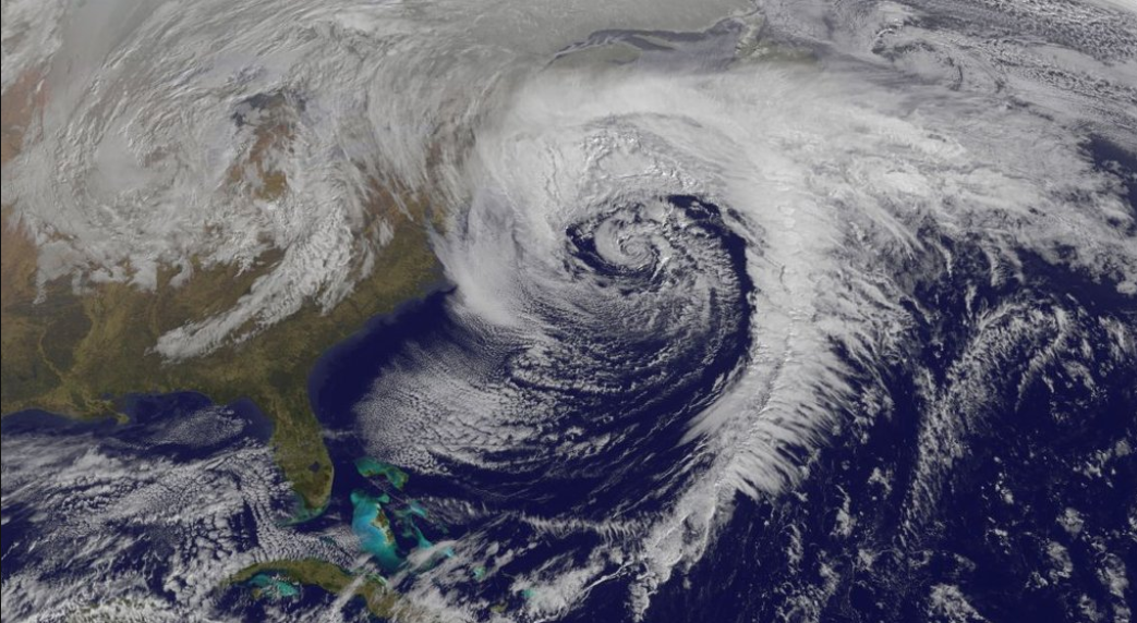
Check out the satellite view of the big system off the East Coast of the United States. You may have heard that Anthem of the Seas cruise ship was caught in this storm. They said it was unexpected. That is the farthest from the truth. This was a well forecast winter storm. If Royal Caribbean did not know about this system then they need to take a deep look at whoever they are following for weather information. NOAA/NWS/private meteorologists, everyone knew this system was going to happen. Well, everyone except for the cruise ship. Which, I find hard to believe.
Here are the snowfall probability numbers for our current snow shower event
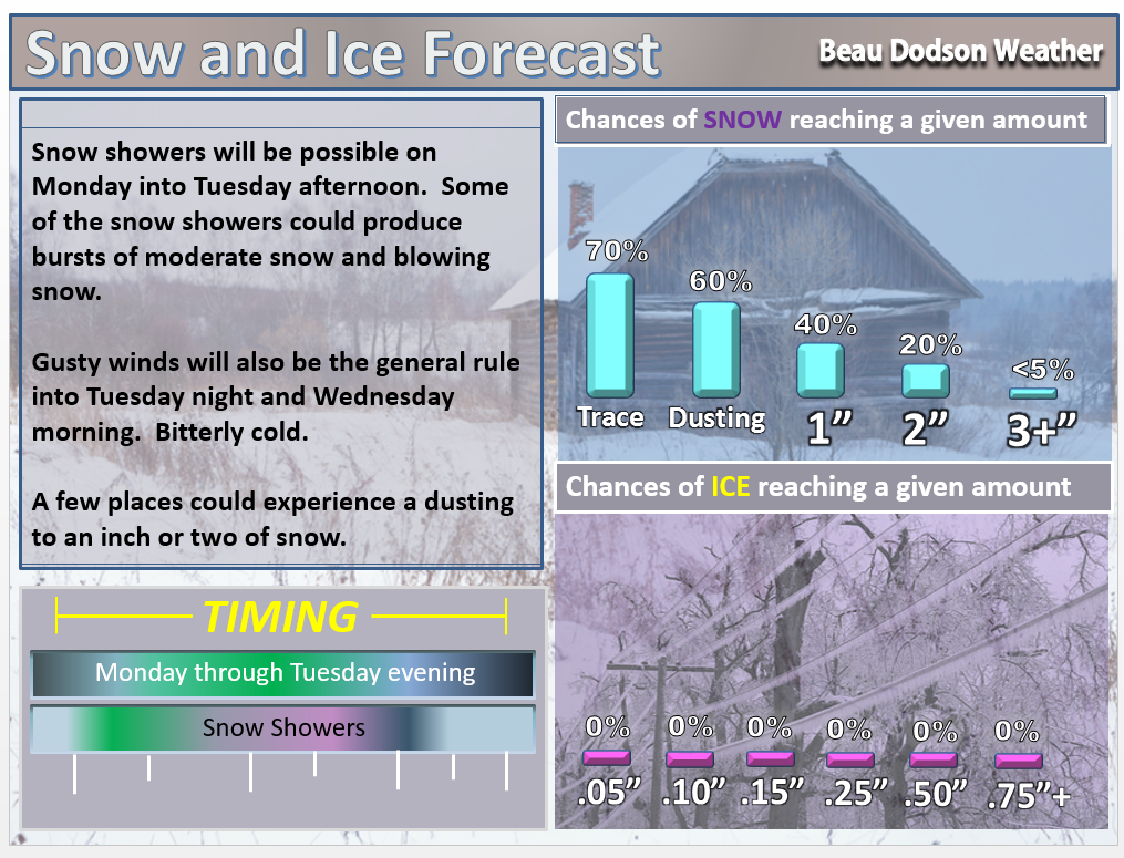

Snow showers possible into Tuesday evening. No accumulation to perhaps 1-2″ in spots.

Monday night – Snow showers possible
Tuesday – Snow showers possible
Wednesday – No snow or ice anticipated.
Thursday – No snow or ice anticipated.
Friday – No snow or ice anticipated.
Saturday – No snow or ice anticipated.

No major changes in this update.

Bitterly cold air combined with strong winds will cause wind chills to dip into the single digits on Monday night into Wednesday. Frost bite is always a concern with conditions such as the above.
Snow showers on Monday and Tuesday. A few spots could experience accumulating snow. Blowing snow, as well. Snow accumulations of none to perhaps 1-2″ over the area.
Odds favor less vs more. Keep that in mind!


The wild card in the forecast will be snow accumulations. Could someone pick up 1-2″ from this event? It is possible. But, odds favor most areas receiving very little in the way of accumulation. Don’t get your hopes up on this event.

How much precipitation should we expect over the next few days?
Light snow showers (from time to time moderate) will continue into Tuesday afternoon/evening.
There is a weak system showing up in the charts for Wednesday night and Thursday. I will need to monitor this for additional precipitation.

Can we expect severe thunderstorms over the next 24 to 48 hours? Remember that a severe thunderstorm is defined as a thunderstorm that produces 58 mph winds or higher, quarter size hail or larger, and/or a tornado.
The thunderstorm threat level will be a ZERO through Thursday.

Here is the official 6-10 day and 8-14 day temperature and precipitation outlook. Check the date stamp at the top of each image (so you understand the time frame).
The forecast maps below are issued by the Weather Prediction Center (NOAA).


The latest 8-14 day temperature and precipitation outlook. Note the dates are at the top of the image. These maps DO NOT tell you how high or low temperatures or precipitation will be. They simply give you the probability as to whether temperatures or precipitation will be above or below normal.


Here are the current river stage forecasts. You can click your state and then the dot for your location. It will bring up the full forecast and hydrograph.
Click Here For River Stage Forecasts…

Who do you trust for your weather information and who holds them accountable?
I have studied weather in our region since the late 1970’s. I have 37 years of experience in observing our regions weather patterns. My degree is in Broadcast Meteorology from Mississippi State University and an Associate of Science (AS). I am currently working on my Bachelor’s Degree in Geoscience.
My resume includes:
Member of the American Meteorological Society.
NOAA Weather-Ready Nation Ambassador.
Meteorologist for McCracken County Emergency Management. I served from 2005 through 2015.
I own and operate the Southern Illinois Weather Observatory.
Recipient of the Mark Trail Award, WPSD Six Who Make A Difference Award, Kentucky Colonel, and the Caesar J. Fiamma” Award from the American Red Cross.
In 2009 I was presented with the Kentucky Office of Highway Safety Award.
Recognized by the Kentucky House of Representatives for my service to the State of Kentucky leading up to several winter storms and severe weather outbreaks.
I am also President of the Shadow Angel Foundation which serves portions of western Kentucky and southern Illinois.
There is a lot of noise on the internet. A lot of weather maps are posted without explanation. Over time you should learn who to trust for your weather information.
My forecast philosophy is simple and straight forward.
- Communicate in simple terms
- To be as accurate as possible within a reasonable time frame before an event
- Interact with you on Twitter, Facebook, and the blog
- Minimize the “hype” that you might see on television or through other weather sources
- Push you towards utilizing wall-to-wall LOCAL TV coverage during severe weather events
I am a recipient of the Mark Trail Award, WPSD Six Who Make A Difference Award, Kentucky Colonel, and the Caesar J. Fiamma” Award from the American Red Cross. In 2009 I was presented with the Kentucky Office of Highway Safety Award. I was recognized by the Kentucky House of Representatives for my service to the State of Kentucky leading up to several winter storms and severe weather outbreaks.
If you click on the image below you can read the Kentucky House of Representatives Resolution.

Many of my graphics are from www.weatherbell.com – a great resource for weather data, model data, and more


You can sign up for my AWARE email by clicking here I typically send out AWARE emails before severe weather, winter storms, or other active weather situations. I do not email watches or warnings. The emails are a basic “heads up” concerning incoming weather conditions.